
Size of this preview:
666 × 599 pixels. Other resolutions:
267 × 240 pixels |
533 × 480 pixels |
681 × 613 pixels.
Original file (681 × 613 pixels, file size: 226 KB, MIME type: image/png)
| This is a file from the
Wikimedia Commons. Information from its
description page there is shown below. Commons is a freely licensed media file repository. You can help. |
Summary
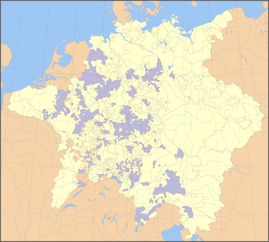
Ecclesiastical lands in the Holy Roman Empire, 1648. Derived from svg map
Licensing

|
Permission is granted to copy, distribute and/or modify this document under the terms of the GNU Free Documentation License, Version 1.2 or any later version published by the Free Software Foundation; with no Invariant Sections, no Front-Cover Texts, and no Back-Cover Texts. A copy of the license is included in the section entitled GNU Free Documentation License. |
| This file is licensed under the Creative Commons Attribution-Share Alike 3.0 Unported license. | ||
| ||
| This licensing tag was added to this file as part of the GFDL licensing update. |
File history
Click on a date/time to view the file as it appeared at that time.
| Date/Time | Thumbnail | Dimensions | User | Comment | |
|---|---|---|---|---|---|
| current | 13:09, 1 May 2007 |
| 681 × 613 (226 KB) | Roke~commonswiki | more subdued colour |
| 00:39, 17 March 2007 |
 | 681 × 595 (209 KB) | Roke~commonswiki | minor fix two areas wrong colour | |
| 11:32, 15 March 2007 |
 | 681 × 595 (267 KB) | Roke~commonswiki | Ecclesiastical lands in the Holy Roman Empire, 1648. Derived from svg map Category:Maps of the Holy Roman Empire |
File usage
The following pages on the English Wikipedia use this file (pages on other projects are not listed):
- Abbey of Saint Gall
- Baindt Abbey
- Buchau Abbey
- Burtscheid Abbey
- Buxheim Charterhouse
- Comburg
- Disentis Abbey
- Elchingen Abbey
- Essen Abbey
- Frauenchiemsee
- Fraumünster
- Gandersheim Abbey
- Gengenbach Abbey
- Gernrode Abbey
- Gutenzell Abbey
- Göss Abbey
- Heggbach Abbey
- Helmarshausen Abbey
- Herford Abbey
- Herrenalb Abbey
- Hersfeld Abbey
- Irsee Abbey
- Kaisheim Abbey
- Klingenmünster Abbey
- Kornelimünster Abbey
- Lindau Abbey
- Lorsch Abbey
- Marchtal Abbey
- Maulbronn Monastery
- Memleben Abbey
- Michaelsberg Abbey, Siegburg
- Mondsee Abbey
- Murbach Abbey
- Neresheim Abbey
- Niedermünster, Regensburg
- Nienburg Abbey
- Obermünster, Regensburg
- Ochsenhausen Abbey
- Ottobeuren Abbey
- Petershausen Abbey
- Prüfening Abbey
- Quedlinburg Abbey
- Reichenau Abbey
- Roggenburg Abbey
- Rot an der Rot Abbey
- Rottweil
- Saint Emmeram's Abbey
- Salem Abbey
- Schussenried Abbey
- Schuttern Abbey
- Schänis Abbey
- St. George's Abbey, Isny
- St. Ludger's Abbey
- St. Maximin's Abbey, Trier
- St. Ulrich's and St. Afra's Abbey
- Söflingen Abbey
- Thorn Abbey
- Ursberg Abbey
- Waldsassen Abbey
- Walkenried Abbey
- Weingarten Abbey
- Weissenau Abbey
- Werden Abbey
- Wettenhausen Abbey
- Wikipedia:WikiProject Former countries/Holy Roman Empire task force
- Template:Rhenish College
- Template:Swabian College
Global file usage
The following other wikis use this file:
- Usage on be.wikipedia.org
- Usage on br.wikipedia.org
- Usage on ca.wikipedia.org
- Usage on da.wikipedia.org
- Usage on de.wikipedia.org
- Usage on en.wiktionary.org
- Usage on eo.wikipedia.org
- Usage on es.wikipedia.org
- Usage on et.wikipedia.org
- Usage on eu.wikipedia.org
- Usage on fr.wikipedia.org
- Usage on it.wikipedia.org
- Regalia
- Abbazia di Weingarten
- Abbazia di Disentis
- Rottweil
- Abbazia di Lorsch
- Abbazia di San Gallo
- Abbazia di Roggenburg
- Abbazia di Murbach
- Abbazia imperiale
- Template:Abbazie Imperiali del Collegio Svevo
- Template:Abbazie Imperiali del Collegio Renano
- Abbazia di Baindt
- Abbazia di Marmoutier
- Abbazia di Buchau
- Abbazia di Burtscheid
- Priorato di Buxheim
- Comburg
- Fraumünster
- Abbazia di Reichenau
- Abbazia di San Massimino
- Abbazia di Gandersheim
- Abbazia di Nienburg
- Abbazia di Gernrode
- Abbazia di Hersfeld
- Abbazia di Memleben
- Usage on ka.wikipedia.org
- Usage on nn.wikipedia.org
- Usage on no.wikipedia.org
- Usage on pt.wikipedia.org
- Usage on ru.wikipedia.org
- Usage on sv.wikipedia.org
- Usage on uk.wikipedia.org
View more global usage of this file.
Size of this preview:
666 × 599 pixels. Other resolutions:
267 × 240 pixels |
533 × 480 pixels |
681 × 613 pixels.
Original file (681 × 613 pixels, file size: 226 KB, MIME type: image/png)
| This is a file from the
Wikimedia Commons. Information from its
description page there is shown below. Commons is a freely licensed media file repository. You can help. |
Summary
Ecclesiastical lands in the Holy Roman Empire, 1648. Derived from svg map
Licensing
|
|
Permission is granted to copy, distribute and/or modify this document under the terms of the GNU Free Documentation License, Version 1.2 or any later version published by the Free Software Foundation; with no Invariant Sections, no Front-Cover Texts, and no Back-Cover Texts. A copy of the license is included in the section entitled GNU Free Documentation License. |
| This file is licensed under the Creative Commons Attribution-Share Alike 3.0 Unported license. | ||
| ||
| This licensing tag was added to this file as part of the GFDL licensing update. |
File history
Click on a date/time to view the file as it appeared at that time.
| Date/Time | Thumbnail | Dimensions | User | Comment | |
|---|---|---|---|---|---|
| current | 13:09, 1 May 2007 |
| 681 × 613 (226 KB) | Roke~commonswiki | more subdued colour |
| 00:39, 17 March 2007 |
| 681 × 595 (209 KB) | Roke~commonswiki | minor fix two areas wrong colour | |
| 11:32, 15 March 2007 |
| 681 × 595 (267 KB) | Roke~commonswiki | Ecclesiastical lands in the Holy Roman Empire, 1648. Derived from svg map Category:Maps of the Holy Roman Empire |
File usage
The following pages on the English Wikipedia use this file (pages on other projects are not listed):
- Abbey of Saint Gall
- Baindt Abbey
- Buchau Abbey
- Burtscheid Abbey
- Buxheim Charterhouse
- Comburg
- Disentis Abbey
- Elchingen Abbey
- Essen Abbey
- Frauenchiemsee
- Fraumünster
- Gandersheim Abbey
- Gengenbach Abbey
- Gernrode Abbey
- Gutenzell Abbey
- Göss Abbey
- Heggbach Abbey
- Helmarshausen Abbey
- Herford Abbey
- Herrenalb Abbey
- Hersfeld Abbey
- Irsee Abbey
- Kaisheim Abbey
- Klingenmünster Abbey
- Kornelimünster Abbey
- Lindau Abbey
- Lorsch Abbey
- Marchtal Abbey
- Maulbronn Monastery
- Memleben Abbey
- Michaelsberg Abbey, Siegburg
- Mondsee Abbey
- Murbach Abbey
- Neresheim Abbey
- Niedermünster, Regensburg
- Nienburg Abbey
- Obermünster, Regensburg
- Ochsenhausen Abbey
- Ottobeuren Abbey
- Petershausen Abbey
- Prüfening Abbey
- Quedlinburg Abbey
- Reichenau Abbey
- Roggenburg Abbey
- Rot an der Rot Abbey
- Rottweil
- Saint Emmeram's Abbey
- Salem Abbey
- Schussenried Abbey
- Schuttern Abbey
- Schänis Abbey
- St. George's Abbey, Isny
- St. Ludger's Abbey
- St. Maximin's Abbey, Trier
- St. Ulrich's and St. Afra's Abbey
- Söflingen Abbey
- Thorn Abbey
- Ursberg Abbey
- Waldsassen Abbey
- Walkenried Abbey
- Weingarten Abbey
- Weissenau Abbey
- Werden Abbey
- Wettenhausen Abbey
- Wikipedia:WikiProject Former countries/Holy Roman Empire task force
- Template:Rhenish College
- Template:Swabian College
Global file usage
The following other wikis use this file:
- Usage on be.wikipedia.org
- Usage on br.wikipedia.org
- Usage on ca.wikipedia.org
- Usage on da.wikipedia.org
- Usage on de.wikipedia.org
- Usage on en.wiktionary.org
- Usage on eo.wikipedia.org
- Usage on es.wikipedia.org
- Usage on et.wikipedia.org
- Usage on eu.wikipedia.org
- Usage on fr.wikipedia.org
- Usage on it.wikipedia.org
- Regalia
- Abbazia di Weingarten
- Abbazia di Disentis
- Rottweil
- Abbazia di Lorsch
- Abbazia di San Gallo
- Abbazia di Roggenburg
- Abbazia di Murbach
- Abbazia imperiale
- Template:Abbazie Imperiali del Collegio Svevo
- Template:Abbazie Imperiali del Collegio Renano
- Abbazia di Baindt
- Abbazia di Marmoutier
- Abbazia di Buchau
- Abbazia di Burtscheid
- Priorato di Buxheim
- Comburg
- Fraumünster
- Abbazia di Reichenau
- Abbazia di San Massimino
- Abbazia di Gandersheim
- Abbazia di Nienburg
- Abbazia di Gernrode
- Abbazia di Hersfeld
- Abbazia di Memleben
- Usage on ka.wikipedia.org
- Usage on nn.wikipedia.org
- Usage on no.wikipedia.org
- Usage on pt.wikipedia.org
- Usage on ru.wikipedia.org
- Usage on sv.wikipedia.org
- Usage on uk.wikipedia.org
View more global usage of this file.