 | |
|
| |
| Location |
Ponta Temerosa Praia Santiago Cape Verde |
|---|---|
| Coordinates | 14°54′1.5″N 23°30′32.6″W / 14.900417°N 23.509056°W |
| Tower | |
| Constructed | 1881 |
| Foundation | concrete base |
| Construction | masonry tower |
| Height | 21 metres (69 ft) [1] |
| Shape | octagonal tower with balcony and lantern attached to 1-storey keeper’s house [2] |
| Markings | white tower, grey lantern roof |
| Heritage | Heritage of Portuguese Influence
|
| Light | |
| Focal height | 25 metres (82 ft) [1] |
| Range | 5 nautical miles (9.3 km; 5.8 mi) [1] |
| Characteristic | Fl (2) W 6s. [1] |
| Cape Verde no. | PT-2136 [2] |
Farol de Dona Maria Pia (also known as Farol da Ponta Temerosa or Farol da Praia) is a lighthouse at the southernmost point of the island of Santiago, Cape Verde. It stands on the headland Ponta Temerosa, at the entrance of Praia Harbour, 2 km south of the city centre of Praia. The lighthouse was built in 1881 and was named after Maria Pia of Savoy, queen of Portugal at the time. The octagonal tower is 21 m high and its focal plane is 25 m above mean sea level. It is painted white. [2] The lighthouse is used for navigational purposes.
Gallery
-
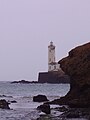 The lighthouse
 -
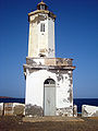 The front door of the lighthouse with the lantern on top
 -
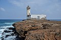
 The lighthouse in Praia Harbour with a tiny view of the city
 -
 The lighthouse on the Ponta Temerosa


See also
References
- ^ a b c d List of Lights, Pub. 113: The West Coasts of Europe and Africa, the Mediterranean Sea, Black Sea and Azovskoye More (Sea of Azov) (PDF). List of Lights. United States National Geospatial-Intelligence Agency. 2018. p. 427.
- ^ a b c Rowlett, Russ. "Lighthouses of Cape Verde". The Lighthouse Directory. University of North Carolina at Chapel Hill.
External links
-
 Media related to
Dona Maria Pia Lighthouse at Wikimedia Commons
Media related to
Dona Maria Pia Lighthouse at Wikimedia Commons - Rowlett, Russ. "Lighthouses of Cape Verde". The Lighthouse Directory. University of North Carolina at Chapel Hill.
- Farol de D. Maria Pia on the World List of Lights
| Neighbourhoods |   | |
|---|---|---|
| Geographical features | ||
| Education | ||
| Landmarks | ||
| Culture | ||
| Sports | ||
| Transportation | ||
| Media | ||
| History | ||
| |
| Authority control databases: Geographic |
|---|
|
| |
|
| |
| Location |
Ponta Temerosa Praia Santiago Cape Verde |
|---|---|
| Coordinates | 14°54′1.5″N 23°30′32.6″W / 14.900417°N 23.509056°W |
| Tower | |
| Constructed | 1881 |
| Foundation | concrete base |
| Construction | masonry tower |
| Height | 21 metres (69 ft) [1] |
| Shape | octagonal tower with balcony and lantern attached to 1-storey keeper’s house [2] |
| Markings | white tower, grey lantern roof |
| Heritage | Heritage of Portuguese Influence
|
| Light | |
| Focal height | 25 metres (82 ft) [1] |
| Range | 5 nautical miles (9.3 km; 5.8 mi) [1] |
| Characteristic | Fl (2) W 6s. [1] |
| Cape Verde no. | PT-2136 [2] |
Farol de Dona Maria Pia (also known as Farol da Ponta Temerosa or Farol da Praia) is a lighthouse at the southernmost point of the island of Santiago, Cape Verde. It stands on the headland Ponta Temerosa, at the entrance of Praia Harbour, 2 km south of the city centre of Praia. The lighthouse was built in 1881 and was named after Maria Pia of Savoy, queen of Portugal at the time. The octagonal tower is 21 m high and its focal plane is 25 m above mean sea level. It is painted white. [2] The lighthouse is used for navigational purposes.
Gallery
-
The lighthouse
-
The front door of the lighthouse with the lantern on top
-
The lighthouse in Praia Harbour with a tiny view of the city
-
The lighthouse on the Ponta Temerosa
See also
References
- ^ a b c d List of Lights, Pub. 113: The West Coasts of Europe and Africa, the Mediterranean Sea, Black Sea and Azovskoye More (Sea of Azov) (PDF). List of Lights. United States National Geospatial-Intelligence Agency. 2018. p. 427.
- ^ a b c Rowlett, Russ. "Lighthouses of Cape Verde". The Lighthouse Directory. University of North Carolina at Chapel Hill.
External links
-
Media related to
Dona Maria Pia Lighthouse at Wikimedia Commons
- Rowlett, Russ. "Lighthouses of Cape Verde". The Lighthouse Directory. University of North Carolina at Chapel Hill.
- Farol de D. Maria Pia on the World List of Lights
| Neighbourhoods | | |
|---|---|---|
| Geographical features | ||
| Education | ||
| Landmarks | ||
| Culture | ||
| Sports | ||
| Transportation | ||
| Media | ||
| History | ||
| |
| Authority control databases: Geographic |
|---|