Ingwierrum | |
|---|---|
Village | |
 Ingwierrum church | |
 Flag  Coat of arms | |
 Location in the former Dongeradeel municipality | |
 Ingwierrum Location in the Netherlands  Ingwierrum Ingwierrum (Netherlands) | |
| Coordinates: 53°19′11″N 6°8′12″E / 53.31972°N 6.13667°E | |
| Country |
|
| Province |
|
| Municipality | Noardeast-Fryslân |
| Area | |
| • Total | 12.32 km2 (4.76 sq mi) |
| Elevation | 1.1 m (3.6 ft) |
| Population (2021)
[1] | |
| • Total | 540 |
| • Density | 44/km2 (110/sq mi) |
| Postal code | 9132
[1] |
| Dialing code | 0519 |
Ingwierrum ( Dutch: Engwierum) is a village in Noardeast-Fryslân in the province of Friesland, the Netherlands. It had a population of approximately 565 in January 2017. [3] Before 2019, the village was part of the Dongeradeel municipality. [4]
History
The village was first mentioned in 1447 as Edygwerum, and means "settlement on the terp of the people of Ede (person)." [5] Ingwierrum is a terp (artificial living mound) village from the early middle ages. The Dutch Reformed church has a possibly 13th century tower which was enlarged in the 14th century. The church building dates from 1746. [6]
In 1719, Ingwierrum was hit by a flood, and the decision was made to dam the Dokkumer Grootdiep. [6] In 1729, an obelisk was placed in Ingwierrum as a monument to the closure of the dike. [7] The locks were restored in 1834. [6] In 1840, Ingwierrum was home to 681 people. [4]
The village's official name was changed from Engwierum to Ingwierrum in 2023. [8] [9]
Gallery
-
 Hotel restaurant in Ingwierrum
 -
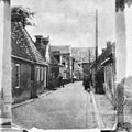 Street view (1920)
 -
 Farm Dodinga State
 -
 Obelisk of Ingwierrum
_-_panoramio_(1).jpg)


References
- ^
a
b
c
"Kerncijfers wijken en buurten 2021". Central Bureau of Statistics. Retrieved 31 March 2022.
two entries
- ^ "Postcodetool for 9132EA". Actueel Hoogtebestand Nederland (in Dutch). Het Waterschapshuis. Retrieved 31 March 2022.
- ^ Aantal inwoners per woonplaats in Dongeradeel op 1 januari 2017 Archived 2017-10-21 at the Wayback Machine - Dongeradeel
- ^ a b "Engwierum". Plaatsengids (in Dutch). Retrieved 31 March 2022.
- ^ "Engwierum - (geografische naam)". Etymologiebank (in Dutch). Retrieved 31 March 2022.
- ^ a b c Ronald Stenvert & Sabine Broekhoven (2000). "Engwierum" (in Dutch). Zwolle: Waanders. ISBN 90 400 9476 4. Retrieved 31 March 2022.
- ^ "Monumentnummer: 23753". Dutch Monuments Register (in Dutch). Retrieved 31 March 2022.
- ^ "22 dorpen in Noardeast-Fryslân krijgen op 1 januari 2023 een nieuwe Friese naam" [22 villages in Noardeast-Fryslân will receive a new Frisian name on 1 January 2023]. RTV NOF (in Dutch). 10 December 2022. Retrieved 7 April 2023.
- ^ "Friese namen" [Frisian names]. Taalunie (in Dutch). Retrieved 7 April 2023.
External links
![]() Media related to
Ingwierrum at Wikimedia Commons
Media related to
Ingwierrum at Wikimedia Commons
|
| This Friesland location article is a stub. You can help Wikipedia by expanding it. |
Ingwierrum | |
|---|---|
Village | |
|
Ingwierrum church | |
|
Flag Coat of arms | |
|
Location in the former Dongeradeel municipality | |
Ingwierrum Location in the Netherlands Ingwierrum Ingwierrum (Netherlands) | |
| Coordinates: 53°19′11″N 6°8′12″E / 53.31972°N 6.13667°E | |
| Country |
|
| Province |
|
| Municipality | Noardeast-Fryslân |
| Area | |
| • Total | 12.32 km2 (4.76 sq mi) |
| Elevation | 1.1 m (3.6 ft) |
| Population (2021)
[1] | |
| • Total | 540 |
| • Density | 44/km2 (110/sq mi) |
| Postal code | 9132
[1] |
| Dialing code | 0519 |
Ingwierrum ( Dutch: Engwierum) is a village in Noardeast-Fryslân in the province of Friesland, the Netherlands. It had a population of approximately 565 in January 2017. [3] Before 2019, the village was part of the Dongeradeel municipality. [4]
History
The village was first mentioned in 1447 as Edygwerum, and means "settlement on the terp of the people of Ede (person)." [5] Ingwierrum is a terp (artificial living mound) village from the early middle ages. The Dutch Reformed church has a possibly 13th century tower which was enlarged in the 14th century. The church building dates from 1746. [6]
In 1719, Ingwierrum was hit by a flood, and the decision was made to dam the Dokkumer Grootdiep. [6] In 1729, an obelisk was placed in Ingwierrum as a monument to the closure of the dike. [7] The locks were restored in 1834. [6] In 1840, Ingwierrum was home to 681 people. [4]
The village's official name was changed from Engwierum to Ingwierrum in 2023. [8] [9]
Gallery
-
Hotel restaurant in Ingwierrum
-
Street view (1920)
-
Farm Dodinga State
-
Obelisk of Ingwierrum
References
- ^
a
b
c
"Kerncijfers wijken en buurten 2021". Central Bureau of Statistics. Retrieved 31 March 2022.
two entries
- ^ "Postcodetool for 9132EA". Actueel Hoogtebestand Nederland (in Dutch). Het Waterschapshuis. Retrieved 31 March 2022.
- ^ Aantal inwoners per woonplaats in Dongeradeel op 1 januari 2017 Archived 2017-10-21 at the Wayback Machine - Dongeradeel
- ^ a b "Engwierum". Plaatsengids (in Dutch). Retrieved 31 March 2022.
- ^ "Engwierum - (geografische naam)". Etymologiebank (in Dutch). Retrieved 31 March 2022.
- ^ a b c Ronald Stenvert & Sabine Broekhoven (2000). "Engwierum" (in Dutch). Zwolle: Waanders. ISBN 90 400 9476 4. Retrieved 31 March 2022.
- ^ "Monumentnummer: 23753". Dutch Monuments Register (in Dutch). Retrieved 31 March 2022.
- ^ "22 dorpen in Noardeast-Fryslân krijgen op 1 januari 2023 een nieuwe Friese naam" [22 villages in Noardeast-Fryslân will receive a new Frisian name on 1 January 2023]. RTV NOF (in Dutch). 10 December 2022. Retrieved 7 April 2023.
- ^ "Friese namen" [Frisian names]. Taalunie (in Dutch). Retrieved 7 April 2023.
External links
![]() Media related to
Ingwierrum at Wikimedia Commons
Media related to
Ingwierrum at Wikimedia Commons
|
| This Friesland location article is a stub. You can help Wikipedia by expanding it. |