Dun-sur-Auron | |
|---|---|
 The church in Dun-sur-Auron | |
.svg) Coat of arms | |
 Dun-sur-Auron  Dun-sur-Auron | |
| Coordinates: 46°53′08″N 2°34′21″E / 46.8856°N 2.5725°E | |
| Country | France |
| Region | Centre-Val de Loire |
| Department | Cher |
| Arrondissement | Saint-Amand-Montrond |
| Canton | Dun-sur-Auron |
| Intercommunality | CC Le Dunois |
| Government | |
| • Mayor (2020–2026) | Louis Cosyns [1] |
| Area 1 | 50.09 km2 (19.34 sq mi) |
| Population (2021)
[2] | 3,572 |
| • Density | 71/km2 (180/sq mi) |
| Time zone | UTC+01:00 ( CET) |
| • Summer ( DST) | UTC+02:00 ( CEST) |
| INSEE/Postal code |
18087 /18130 |
| Elevation | 151–188 m (495–617 ft) (avg. 174 m or 571 ft) |
| 1 French Land Register data, which excludes lakes, ponds, glaciers > 1 km2 (0.386 sq mi or 247 acres) and river estuaries. | |
Dun-sur-Auron (French pronunciation: [dœ̃ syʁ oʁɔ̃], literally Dun on Auron) is a commune in the Cher department in the Centre-Val de Loire region of France.
Geography
A farming area comprising a small town and a couple of hamlets situated by the banks of both the Auron and the canal de Berry some 26 miles (42 km) east of Bourges at the junction of the D10, D14, D28, D34 and the D943 roads. Another small river, the Airain flows northwest through the northern part of the commune.
Population
| Year | Pop. | ±% p.a. |
|---|---|---|
| 1968 | 3,995 | — |
| 1975 | 4,154 | +0.56% |
| 1982 | 4,238 | +0.29% |
| 1990 | 4,261 | +0.07% |
| 1999 | 4,013 | −0.66% |
| 2007 | 3,881 | −0.42% |
| 2012 | 4,293 | +2.04% |
| 2017 | 3,844 | −2.19% |
| Source: INSEE [3] | ||
History
Dun-sur-Auron dates back from Dunum, a Gaul fortified place. In the Middle Ages it depended from the Viscount of Bourges. In 1101, the last viscount, Eudes Arpin, lord of Dun, sold his estates to King Philip I of France and the city was renamed Dun-le-Roi.
Sights
- The sixteenth-century town walls
- The twelfth-century church of St. Etienne.
- Fifteenth-century houses.
- A feudal motte castle.
- The chateau of La Périsse.
- The belltower.
- A museum.
- "Le Prieuré", built late 1400, Place Bourbon.
-
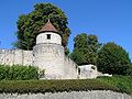 Walls and towers
 -
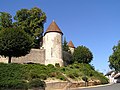 Fortifications
 -
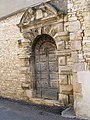 A gateway in the walls


-
 The church entrance
 -
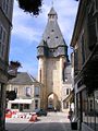 The bell tower


Personalities
- Maurice Bardèche (1907–1998), journalist and writer.
- Érick Jacquin (1964–Present), chef and TV personality.
See also
References
- ^ "Répertoire national des élus: les maires". data.gouv.fr, Plateforme ouverte des données publiques françaises (in French). 2 December 2020.
- ^ "Populations légales 2021" (in French). The National Institute of Statistics and Economic Studies. 28 December 2023.
- ^ Population en historique depuis 1968, INSEE
External links
- Official town website (in French)
| National | |
|---|---|
| Geographic | |
| Other | |
Dun-sur-Auron | |
|---|---|
|
The church in Dun-sur-Auron | |
|
Coat of arms | |
Dun-sur-Auron Dun-sur-Auron | |
| Coordinates: 46°53′08″N 2°34′21″E / 46.8856°N 2.5725°E | |
| Country | France |
| Region | Centre-Val de Loire |
| Department | Cher |
| Arrondissement | Saint-Amand-Montrond |
| Canton | Dun-sur-Auron |
| Intercommunality | CC Le Dunois |
| Government | |
| • Mayor (2020–2026) | Louis Cosyns [1] |
| Area 1 | 50.09 km2 (19.34 sq mi) |
| Population (2021)
[2] | 3,572 |
| • Density | 71/km2 (180/sq mi) |
| Time zone | UTC+01:00 ( CET) |
| • Summer ( DST) | UTC+02:00 ( CEST) |
| INSEE/Postal code |
18087 /18130 |
| Elevation | 151–188 m (495–617 ft) (avg. 174 m or 571 ft) |
| 1 French Land Register data, which excludes lakes, ponds, glaciers > 1 km2 (0.386 sq mi or 247 acres) and river estuaries. | |
Dun-sur-Auron (French pronunciation: [dœ̃ syʁ oʁɔ̃], literally Dun on Auron) is a commune in the Cher department in the Centre-Val de Loire region of France.
Geography
A farming area comprising a small town and a couple of hamlets situated by the banks of both the Auron and the canal de Berry some 26 miles (42 km) east of Bourges at the junction of the D10, D14, D28, D34 and the D943 roads. Another small river, the Airain flows northwest through the northern part of the commune.
Population
| Year | Pop. | ±% p.a. |
|---|---|---|
| 1968 | 3,995 | — |
| 1975 | 4,154 | +0.56% |
| 1982 | 4,238 | +0.29% |
| 1990 | 4,261 | +0.07% |
| 1999 | 4,013 | −0.66% |
| 2007 | 3,881 | −0.42% |
| 2012 | 4,293 | +2.04% |
| 2017 | 3,844 | −2.19% |
| Source: INSEE [3] | ||
History
Dun-sur-Auron dates back from Dunum, a Gaul fortified place. In the Middle Ages it depended from the Viscount of Bourges. In 1101, the last viscount, Eudes Arpin, lord of Dun, sold his estates to King Philip I of France and the city was renamed Dun-le-Roi.
Sights
- The sixteenth-century town walls
- The twelfth-century church of St. Etienne.
- Fifteenth-century houses.
- A feudal motte castle.
- The chateau of La Périsse.
- The belltower.
- A museum.
- "Le Prieuré", built late 1400, Place Bourbon.
-
Walls and towers
-
Fortifications
-
A gateway in the walls
-
The church entrance
-
The bell tower
Personalities
- Maurice Bardèche (1907–1998), journalist and writer.
- Érick Jacquin (1964–Present), chef and TV personality.
See also
References
- ^ "Répertoire national des élus: les maires". data.gouv.fr, Plateforme ouverte des données publiques françaises (in French). 2 December 2020.
- ^ "Populations légales 2021" (in French). The National Institute of Statistics and Economic Studies. 28 December 2023.
- ^ Population en historique depuis 1968, INSEE
External links
- Official town website (in French)
| National | |
|---|---|
| Geographic | |
| Other | |