This article needs additional citations for
verification. (February 2020) |
Coolgreany
Cúil Ghréine | |
|---|---|
Village | |
 Coolgreany village | |
| Coordinates: 52°45′54″N 6°14′02″W / 52.765°N 6.234°W | |
| Country | Ireland |
| Province | Leinster |
| County | County Wexford |
| Elevation | 48 m (157 ft) |
| Population | 376 |
| Time zone | UTC+0 ( WET) |
| • Summer ( DST) | UTC-1 ( IST ( WEST)) |
| Irish Grid Reference | T181683 |
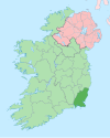
Coolgreany ( Irish: Cúil Ghréine, meaning "nook of the sun") [2] [3] is a village located in north County Wexford in Ireland, in the shadow of Croghan Mountain, overlooking Tara Hill in the extreme north of County Wexford.
The village is located about 3 km from the N11 Dublin-Wexford road at Inch. Amenities include a Gaelic Athletic Association pitch, handball alley, a grocery store, two pubs (public houses) and national (primary) school. The primary school opened in the early 1980s.
Nearby major towns are Arklow and Gorey.
Historically the village is known for the evictions of 1887. [4]
See also
References
- ^ "Sapmap Area - Settlements - Coolgreany". Census 2016. Central Statistics Office. April 2016. Retrieved 22 March 2020.
- ^ A. D. Mills (2003). A Dictionary of British Place-Names. Oxford University Press.
- ^ "Cúil Ghréine / Coolgreany". logainm.ie. Irish Placenames Commission. Retrieved 22 March 2020.
- ^ "Coolgreany". North Wexford.com. Archived from the original on 21 April 2008. Retrieved 16 May 2008.
External links
This article needs additional citations for
verification. (February 2020) |
Coolgreany
Cúil Ghréine | |
|---|---|
Village | |
 Coolgreany village | |
| Coordinates: 52°45′54″N 6°14′02″W / 52.765°N 6.234°W | |
| Country | Ireland |
| Province | Leinster |
| County | County Wexford |
| Elevation | 48 m (157 ft) |
| Population | 376 |
| Time zone | UTC+0 ( WET) |
| • Summer ( DST) | UTC-1 ( IST ( WEST)) |
| Irish Grid Reference | T181683 |
Coolgreany ( Irish: Cúil Ghréine, meaning "nook of the sun") [2] [3] is a village located in north County Wexford in Ireland, in the shadow of Croghan Mountain, overlooking Tara Hill in the extreme north of County Wexford.
The village is located about 3 km from the N11 Dublin-Wexford road at Inch. Amenities include a Gaelic Athletic Association pitch, handball alley, a grocery store, two pubs (public houses) and national (primary) school. The primary school opened in the early 1980s.
Nearby major towns are Arklow and Gorey.
Historically the village is known for the evictions of 1887. [4]
See also
References
- ^ "Sapmap Area - Settlements - Coolgreany". Census 2016. Central Statistics Office. April 2016. Retrieved 22 March 2020.
- ^ A. D. Mills (2003). A Dictionary of British Place-Names. Oxford University Press.
- ^ "Cúil Ghréine / Coolgreany". logainm.ie. Irish Placenames Commission. Retrieved 22 March 2020.
- ^ "Coolgreany". North Wexford.com. Archived from the original on 21 April 2008. Retrieved 16 May 2008.

