| Cleveland Peak | |
|---|---|
 West aspect | |
| Highest point | |
| Elevation | 13,414 ft (4,089 m) [1] [2] |
| Prominence | 450 ft (137 m) [3] |
| Parent peak | Tijeras Peak (13,610 ft) [3] |
| Isolation | 1.40 mi (2.25 km) [3] |
| Coordinates | 37°54′16″N 105°32′36″W / 37.9044132°N 105.5432036°W [4] |
| Geography | |
 Cleveland Peak Location in Colorado  Cleveland Peak Cleveland Peak (the United States) | |
| Country | United States |
| State | Colorado |
| County | Saguache |
| Protected area |
Sangre de Cristo Wilderness Great Sand Dunes Preserve |
| Parent range |
Rocky Mountains Sangre de Cristo Range [2] |
| Topo map | USGS Crestone Peak |
| Geology | |
| Age of rock | Precambrian [5] |
| Mountain type | Fault block |
| Climbing | |
| Easiest route | class 2+ [3] |
Cleveland Peak is a 13,414-foot (4,089 m) mountain summit in Saguache County, Colorado, United States.
Cleveland Peak is set in the Sangre de Cristo Range which is a subrange of the Rocky Mountains. [2] The mountain is located on the boundary shared by Sangre de Cristo Wilderness and Great Sand Dunes National Park and Preserve. [3] Precipitation runoff from the mountain's eastern slopes drains to Sand Creek, the west slope drains into Pole and Deadman creeks, and all three flow into the San Luis Valley. Topographic relief is significant as the summit rises 1,700 feet (518 m) above Deadman Lakes in one-half mile (0.8 km) and nearly 4,600 feet (1,402 m) above Sand Creek in 2.5 miles (4.0 km). The mountain's toponym has been officially adopted by the United States Board on Geographic Names. [4]
According to the Köppen climate classification system, Cleveland Peak has an alpine climate with cold, snowy winters, and cool to warm summers. [6] Due to its altitude, it receives precipitation all year, as snow in winter and as thunderstorms in summer, with a dry period in late spring. Climbers can expect afternoon rain, hail, and lightning from the seasonal monsoon in late July and August.
-
 Cleveland Peak and Great Sand Dunes
 -
 Cleveland Peak and Great Sand Dunes
 -
 Great Sand Dunes and Cleveland Peak
 -
 Cleveland Peak at sunset
 -
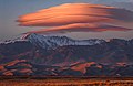 Lenticular cloud over Cleveland Peak at sunset
 -
 Cleveland Peak centered and the Crestones to the left
 -
 Great Sand Dunes and Cleveland Peak
 -
 Cleveland Peak to right and the Crestones to the left
.jpg)
.jpg)
.jpg)

.jpg)

.jpg)
.jpg)
- ^ Robert M. Ormes (2000), Guide to the Colorado Mountains, Colorado Mountain Club Press, ISBN 9780967146607, p. 115.
- ^ a b c "Cleveland Peak, Colorado". Peakbagger.com. Retrieved May 28, 2023.
- ^ a b c d e "Cleveland Peak – 13,404' CO". listsofjohn.com. Retrieved May 28, 2023.
- ^ a b "Cleveland Peak". Geographic Names Information System. United States Geological Survey, United States Department of the Interior. Retrieved May 28, 2023.
- ^ Nicholas Lancaster (2020), Inland Dunes of North America, Springer International Publishing, ISBN 9783030404987, p. 245.
- ^ Peel, M. C.; Finlayson, B. L.; McMahon, T. A. (2007). "Updated world map of the Köppen−Geiger climate classification". Hydrol. Earth Syst. Sci. 11. ISSN 1027-5606.
- Cleveland Peak: weather forecast
Places adjacent to Cleveland Peak | ||||||||||||||||
|---|---|---|---|---|---|---|---|---|---|---|---|---|---|---|---|---|
| ||||||||||||||||
| Cleveland Peak | |
|---|---|
|
West aspect | |
| Highest point | |
| Elevation | 13,414 ft (4,089 m) [1] [2] |
| Prominence | 450 ft (137 m) [3] |
| Parent peak | Tijeras Peak (13,610 ft) [3] |
| Isolation | 1.40 mi (2.25 km) [3] |
| Coordinates | 37°54′16″N 105°32′36″W / 37.9044132°N 105.5432036°W [4] |
| Geography | |
Cleveland Peak Location in Colorado Cleveland Peak Cleveland Peak (the United States) | |
| Country | United States |
| State | Colorado |
| County | Saguache |
| Protected area |
Sangre de Cristo Wilderness Great Sand Dunes Preserve |
| Parent range |
Rocky Mountains Sangre de Cristo Range [2] |
| Topo map | USGS Crestone Peak |
| Geology | |
| Age of rock | Precambrian [5] |
| Mountain type | Fault block |
| Climbing | |
| Easiest route | class 2+ [3] |
Cleveland Peak is a 13,414-foot (4,089 m) mountain summit in Saguache County, Colorado, United States.
Cleveland Peak is set in the Sangre de Cristo Range which is a subrange of the Rocky Mountains. [2] The mountain is located on the boundary shared by Sangre de Cristo Wilderness and Great Sand Dunes National Park and Preserve. [3] Precipitation runoff from the mountain's eastern slopes drains to Sand Creek, the west slope drains into Pole and Deadman creeks, and all three flow into the San Luis Valley. Topographic relief is significant as the summit rises 1,700 feet (518 m) above Deadman Lakes in one-half mile (0.8 km) and nearly 4,600 feet (1,402 m) above Sand Creek in 2.5 miles (4.0 km). The mountain's toponym has been officially adopted by the United States Board on Geographic Names. [4]
According to the Köppen climate classification system, Cleveland Peak has an alpine climate with cold, snowy winters, and cool to warm summers. [6] Due to its altitude, it receives precipitation all year, as snow in winter and as thunderstorms in summer, with a dry period in late spring. Climbers can expect afternoon rain, hail, and lightning from the seasonal monsoon in late July and August.
-
Cleveland Peak and Great Sand Dunes
-
Cleveland Peak and Great Sand Dunes
-
Great Sand Dunes and Cleveland Peak
-
Cleveland Peak at sunset
-
Lenticular cloud over Cleveland Peak at sunset
-
Cleveland Peak centered and the Crestones to the left
-
Great Sand Dunes and Cleveland Peak
-
Cleveland Peak to right and the Crestones to the left
- ^ Robert M. Ormes (2000), Guide to the Colorado Mountains, Colorado Mountain Club Press, ISBN 9780967146607, p. 115.
- ^ a b c "Cleveland Peak, Colorado". Peakbagger.com. Retrieved May 28, 2023.
- ^ a b c d e "Cleveland Peak – 13,404' CO". listsofjohn.com. Retrieved May 28, 2023.
- ^ a b "Cleveland Peak". Geographic Names Information System. United States Geological Survey, United States Department of the Interior. Retrieved May 28, 2023.
- ^ Nicholas Lancaster (2020), Inland Dunes of North America, Springer International Publishing, ISBN 9783030404987, p. 245.
- ^ Peel, M. C.; Finlayson, B. L.; McMahon, T. A. (2007). "Updated world map of the Köppen−Geiger climate classification". Hydrol. Earth Syst. Sci. 11. ISSN 1027-5606.
- Cleveland Peak: weather forecast
Places adjacent to Cleveland Peak | ||||||||||||||||
|---|---|---|---|---|---|---|---|---|---|---|---|---|---|---|---|---|
| ||||||||||||||||
| Book Cliffs | |||||||||||
|---|---|---|---|---|---|---|---|---|---|---|---|
| Elk Mountains | |||||||||||
| Elkhead Mountains | |||||||||||
| Flat Tops | |||||||||||
| Front Range |
| ||||||||||
| Gore Range | |||||||||||
| Grand Mesa | |||||||||||
| Laramie Mountains | |||||||||||
| Medicine Bow Mountains | |||||||||||
| Mosquito Range | |||||||||||
| Park Range | |||||||||||
| Rabbit Ears Range | |||||||||||
| Raton Mesa | |||||||||||
| San Juan Mountains |
| ||||||||||
| Sangre de Cristo Mountains |
| ||||||||||
| Sawatch Range |
| ||||||||||
| Spanish Peaks | |||||||||||
| Tenmile Range | |||||||||||
| Uinta Mountains | |||||||||||
| West Elk Mountains | |||||||||||
| Others | |||||||||||