| Peak One | |
|---|---|
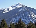
 North aspect of Peak One | |
| Highest point | |
| Elevation | 12,805 ft (3,903 m) [1] [2] |
| Prominence | 225 ft (69 m) [3] |
| Parent peak | Tenmile Peak (12,938 ft) [3] |
| Isolation | 0.49 mi (0.79 km) [3] |
| Coordinates | 39°32′35″N 106°07′12″W / 39.5430027°N 106.1199036°W [4] |
| Geography | |
 Peak One Location in Colorado  Peak One Peak One (the United States) | |
| Country | United States |
| State | Colorado |
| County | Summit County |
| Parent range |
Rocky Mountains Tenmile Range [5] |
| Topo map | USGS Frisco |
| Geology | |
| Age of rock | Precambrian [6] |
| Type of rock | Metamorphic rock [6] |
| Climbing | |
| Easiest route | class 2+ [3] |
Peak One is a 12,805-foot (3,903 m) mountain summit in Summit County, Colorado, United States.
Description
Peak One is set 15 miles (24 km) west of the Continental Divide at the northern end of the Tenmile Range which is a subrange of the Rocky Mountains. [5] The mountain is located 2.5 miles (4.0 km) south of the community of Frisco, [4] and is set on land managed by Arapaho National Forest. [2] Interstate 70 runs along the western base of the peak. Precipitation runoff from the mountain's west slope drains into Tenmile Creek and the east slope drains to Miners Creek, which both empty into Dillon Reservoir. Topographic relief is significant as the summit rises 3,400 feet (1,036 m) above Tenmile Creek in one mile (1.6 km). The mountain's toponym has been officially adopted by the United States Board on Geographic Names in favor of rejected variant names such as "Peak 1", "Peak Number One", "Tenmile Range Peak 1", and "Melzer Peak." [4]
Climate
According to the Köppen climate classification system, Peak 1 is located in an alpine subarctic climate zone with cold, snowy winters, and cool to warm summers. [7] Due to its altitude, it receives precipitation all year, as snow in winter and as thunderstorms in summer, with a dry period in late spring. The months of June through September offer the most favorable conditions for climbing Peak One. [2]
Gallery
-
 Peak One (centered) with Tenmile Peak to left
 -
 Tenmile Peak (left of center) and Peak 1
 -
 Peak One viewed from the scenic lookout near Frisco, CO.
 -
 Tenmile Peak (center) and Peak 1 (right of center) beyond Dillon Reservoir
.jpg)


See also
References
- ^ Randy Jacobs, Robert Ormes (2000), Guide to the Colorado Mountains, Colorado Mountain Club Press, ISBN 9780967146607, p. 162.
- ^ a b c James Dziezynski (2016), Best Summit Hikes Denver to Vail, Wilderness Press, ISBN 9780899978123, p. 121–123.
- ^ a b c d "Peak 1 - 12,805' CO". listsofjohn.com. Retrieved April 17, 2023.
- ^ a b c "Peak One". Geographic Names Information System. United States Geological Survey, United States Department of the Interior. Retrieved April 17, 2023.
- ^ a b "Peak 1, Colorado". Peakbagger.com. Retrieved April 17, 2023.
- ^ a b Max H. Bergendahl (1963), Geology of the Northern Part of the Tenmile Range, Summit County Colorado, Geological Survey Bulletin 1162-D, US Government Printing Office.
- ^ Peel, M. C.; Finlayson, B. L.; McMahon, T. A. (2007). "Updated world map of the Köppen−Geiger climate classification". Hydrol. Earth Syst. Sci. 11. ISSN 1027-5606.
External links
- Peak One: weather forecast
Places adjacent to Peak One | ||||||||||||||||
|---|---|---|---|---|---|---|---|---|---|---|---|---|---|---|---|---|
| ||||||||||||||||
| Peak One | |
|---|---|
|
North aspect of Peak One | |
| Highest point | |
| Elevation | 12,805 ft (3,903 m) [1] [2] |
| Prominence | 225 ft (69 m) [3] |
| Parent peak | Tenmile Peak (12,938 ft) [3] |
| Isolation | 0.49 mi (0.79 km) [3] |
| Coordinates | 39°32′35″N 106°07′12″W / 39.5430027°N 106.1199036°W [4] |
| Geography | |
Peak One Location in Colorado Peak One Peak One (the United States) | |
| Country | United States |
| State | Colorado |
| County | Summit County |
| Parent range |
Rocky Mountains Tenmile Range [5] |
| Topo map | USGS Frisco |
| Geology | |
| Age of rock | Precambrian [6] |
| Type of rock | Metamorphic rock [6] |
| Climbing | |
| Easiest route | class 2+ [3] |
Peak One is a 12,805-foot (3,903 m) mountain summit in Summit County, Colorado, United States.
Description
Peak One is set 15 miles (24 km) west of the Continental Divide at the northern end of the Tenmile Range which is a subrange of the Rocky Mountains. [5] The mountain is located 2.5 miles (4.0 km) south of the community of Frisco, [4] and is set on land managed by Arapaho National Forest. [2] Interstate 70 runs along the western base of the peak. Precipitation runoff from the mountain's west slope drains into Tenmile Creek and the east slope drains to Miners Creek, which both empty into Dillon Reservoir. Topographic relief is significant as the summit rises 3,400 feet (1,036 m) above Tenmile Creek in one mile (1.6 km). The mountain's toponym has been officially adopted by the United States Board on Geographic Names in favor of rejected variant names such as "Peak 1", "Peak Number One", "Tenmile Range Peak 1", and "Melzer Peak." [4]
Climate
According to the Köppen climate classification system, Peak 1 is located in an alpine subarctic climate zone with cold, snowy winters, and cool to warm summers. [7] Due to its altitude, it receives precipitation all year, as snow in winter and as thunderstorms in summer, with a dry period in late spring. The months of June through September offer the most favorable conditions for climbing Peak One. [2]
Gallery
-
Peak One (centered) with Tenmile Peak to left
-
Tenmile Peak (left of center) and Peak 1
-
Peak One viewed from the scenic lookout near Frisco, CO.
-
Tenmile Peak (center) and Peak 1 (right of center) beyond Dillon Reservoir
See also
References
- ^ Randy Jacobs, Robert Ormes (2000), Guide to the Colorado Mountains, Colorado Mountain Club Press, ISBN 9780967146607, p. 162.
- ^ a b c James Dziezynski (2016), Best Summit Hikes Denver to Vail, Wilderness Press, ISBN 9780899978123, p. 121–123.
- ^ a b c d "Peak 1 - 12,805' CO". listsofjohn.com. Retrieved April 17, 2023.
- ^ a b c "Peak One". Geographic Names Information System. United States Geological Survey, United States Department of the Interior. Retrieved April 17, 2023.
- ^ a b "Peak 1, Colorado". Peakbagger.com. Retrieved April 17, 2023.
- ^ a b Max H. Bergendahl (1963), Geology of the Northern Part of the Tenmile Range, Summit County Colorado, Geological Survey Bulletin 1162-D, US Government Printing Office.
- ^ Peel, M. C.; Finlayson, B. L.; McMahon, T. A. (2007). "Updated world map of the Köppen−Geiger climate classification". Hydrol. Earth Syst. Sci. 11. ISSN 1027-5606.
External links
- Peak One: weather forecast
Places adjacent to Peak One | ||||||||||||||||
|---|---|---|---|---|---|---|---|---|---|---|---|---|---|---|---|---|
| ||||||||||||||||
| Book Cliffs | |||||||||||
|---|---|---|---|---|---|---|---|---|---|---|---|
| Elk Mountains | |||||||||||
| Elkhead Mountains | |||||||||||
| Flat Tops | |||||||||||
| Front Range |
| ||||||||||
| Gore Range | |||||||||||
| Grand Mesa | |||||||||||
| Laramie Mountains | |||||||||||
| Medicine Bow Mountains | |||||||||||
| Mosquito Range | |||||||||||
| Park Range | |||||||||||
| Rabbit Ears Range | |||||||||||
| Raton Mesa | |||||||||||
| San Juan Mountains |
| ||||||||||
| Sangre de Cristo Mountains |
| ||||||||||
| Sawatch Range |
| ||||||||||
| Spanish Peaks | |||||||||||
| Tenmile Range | |||||||||||
| Uinta Mountains | |||||||||||
| West Elk Mountains | |||||||||||
| Others | |||||||||||