| Barkston Ash | |
|---|---|
 Boundary stone on junction of Main Street with the A162 road | |
.svg) Barkston Ash Location within
North Yorkshire | |
| Population | 370 ( 2011 census) [1] |
| OS grid reference | SE491361 |
| Civil parish |
|
| Unitary authority | |
| Ceremonial county | |
| Region | |
| Country | England |
| Sovereign state | United Kingdom |
| Post town | TADCASTER |
| Postcode district | LS24 |
| Police | North Yorkshire |
| Fire | North Yorkshire |
| Ambulance | Yorkshire |
Barkston Ash is a small village and civil parish close to Selby in North Yorkshire, England. It was formerly known as Barkston, in the West Riding of Yorkshire. [2] [3] In 2011 the parish had a population of 370.
History
The village dates back to at least 1090, when it was spelled Barcestone. [3] It was part of the Selby District from 1974 until 2023, the village previously gave its name to the former wapentake of Barkston Ash. [4] The Ash part of the name comes from a large ash tree said to be at the approximate centre of the ancient county of Yorkshire, where meetings for the wapentake would be held. [2] [5]
What is now the A162 London Road was a turnpike constructed in 1769: the Main Street and the major part of the village goes East from the junction with this. [5]
On 14 October 1976 the parish was renamed from "Barkston" to "Barkston Ash". [6]
Barkston Ash was also the name of the local parliamentary constituency of Barkston Ash until 1983, when its boundaries were redrawn to divide the area into Elmet and Selby. [3]
Features
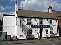
The village contains a small Church of England church, Holy Trinity originally a chapel of ease constructed in 1880, but given its current name and status in 1974. [5] There are two pubs, the Ash Tree (on the site of a former coaching inn) and the Boot and Shoe, a village hall and a primary school (dating from 1856). [7] There were formerly two shops and a post office on Main Street, now private residences. [3]
There are three 17th to 19th century stone Grade II listed building houses near the junction of Main Street and Church Street: Laurel Farm, [8] Barkston House, [9] and Turpin Hall Farm. [10]
See also
-
 Ash Tree pub
 -
 Boot and Shoe pub
 -
 Former post office
 -
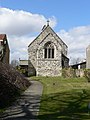 Holy Trinity Church


References
- ^ UK Census (2011). "Local Area Report – Barkston Ash Parish (1170217377)". Nomis. Office for National Statistics. Retrieved 10 March 2018.
- ^
a
b Lewis, Samuel.
"Barkston". ukga.org. UK Genealogy Archives. Retrieved 12 July 2018.
Transcribed from A Topographical Dictionary of England, by Samuel Lewis, 7th edition, published in 1848.
- ^ a b c d "About Barkston Ash". barkstonash.co.uk. Barkston Ash Parish Council. Retrieved 12 July 2018.
- ^ Langdale, Thomas (1822). A topographical dictionary of Yorkshire; containing the names of all the towns, villages, hamlets, gentlemen's seats, &c. in the county of York. Northallerton: Langdale J. p. 149. OCLC 5211910.
- ^ a b c North Yorkshire Federation of Women's Institutes (1991). North Yorkshire Village Book. Countryside Books. p. 26. ISBN 978-1853061370.
- ^ "Selby Registration District". UKBMD. Retrieved 8 May 2024.
- ^ "Barkston Ash Catholic Primary School". barkstonash.n-yorks.sch.uk. Retrieved 26 April 2019.
- ^ Historic England. "Laurel Farm (1148434)". National Heritage List for England. Retrieved 12 July 2018.
- ^ Historic England. "Barkston House (1316334)". National Heritage List for England. Retrieved 12 July 2018.
- ^ Historic England. "Turpin Hall Farm (1148433)". National Heritage List for England. Retrieved 12 July 2018.
External links
- Barston Ash village website
- The Ancient Parish of Sherburn in Elmet at GENUKI: Barkston Ash was in this parish
| Barkston Ash | |
|---|---|
|
Boundary stone on junction of Main Street with the A162 road | |
Barkston Ash Location within
North Yorkshire | |
| Population | 370 ( 2011 census) [1] |
| OS grid reference | SE491361 |
| Civil parish |
|
| Unitary authority | |
| Ceremonial county | |
| Region | |
| Country | England |
| Sovereign state | United Kingdom |
| Post town | TADCASTER |
| Postcode district | LS24 |
| Police | North Yorkshire |
| Fire | North Yorkshire |
| Ambulance | Yorkshire |
Barkston Ash is a small village and civil parish close to Selby in North Yorkshire, England. It was formerly known as Barkston, in the West Riding of Yorkshire. [2] [3] In 2011 the parish had a population of 370.
History
The village dates back to at least 1090, when it was spelled Barcestone. [3] It was part of the Selby District from 1974 until 2023, the village previously gave its name to the former wapentake of Barkston Ash. [4] The Ash part of the name comes from a large ash tree said to be at the approximate centre of the ancient county of Yorkshire, where meetings for the wapentake would be held. [2] [5]
What is now the A162 London Road was a turnpike constructed in 1769: the Main Street and the major part of the village goes East from the junction with this. [5]
On 14 October 1976 the parish was renamed from "Barkston" to "Barkston Ash". [6]
Barkston Ash was also the name of the local parliamentary constituency of Barkston Ash until 1983, when its boundaries were redrawn to divide the area into Elmet and Selby. [3]
Features
The village contains a small Church of England church, Holy Trinity originally a chapel of ease constructed in 1880, but given its current name and status in 1974. [5] There are two pubs, the Ash Tree (on the site of a former coaching inn) and the Boot and Shoe, a village hall and a primary school (dating from 1856). [7] There were formerly two shops and a post office on Main Street, now private residences. [3]
There are three 17th to 19th century stone Grade II listed building houses near the junction of Main Street and Church Street: Laurel Farm, [8] Barkston House, [9] and Turpin Hall Farm. [10]
See also
-
Ash Tree pub
-
Boot and Shoe pub
-
Former post office
-
Holy Trinity Church
References
- ^ UK Census (2011). "Local Area Report – Barkston Ash Parish (1170217377)". Nomis. Office for National Statistics. Retrieved 10 March 2018.
- ^
a
b Lewis, Samuel.
"Barkston". ukga.org. UK Genealogy Archives. Retrieved 12 July 2018.
Transcribed from A Topographical Dictionary of England, by Samuel Lewis, 7th edition, published in 1848.
- ^ a b c d "About Barkston Ash". barkstonash.co.uk. Barkston Ash Parish Council. Retrieved 12 July 2018.
- ^ Langdale, Thomas (1822). A topographical dictionary of Yorkshire; containing the names of all the towns, villages, hamlets, gentlemen's seats, &c. in the county of York. Northallerton: Langdale J. p. 149. OCLC 5211910.
- ^ a b c North Yorkshire Federation of Women's Institutes (1991). North Yorkshire Village Book. Countryside Books. p. 26. ISBN 978-1853061370.
- ^ "Selby Registration District". UKBMD. Retrieved 8 May 2024.
- ^ "Barkston Ash Catholic Primary School". barkstonash.n-yorks.sch.uk. Retrieved 26 April 2019.
- ^ Historic England. "Laurel Farm (1148434)". National Heritage List for England. Retrieved 12 July 2018.
- ^ Historic England. "Barkston House (1316334)". National Heritage List for England. Retrieved 12 July 2018.
- ^ Historic England. "Turpin Hall Farm (1148433)". National Heritage List for England. Retrieved 12 July 2018.
External links
- Barston Ash village website
- The Ancient Parish of Sherburn in Elmet at GENUKI: Barkston Ash was in this parish