The county is the largest in England by land area, at 8,654 km2 (3,480 sq mi), and had a population of 1,158,816 in 2021. The largest settlements are Middlesbrough (148,215) in the north-east and the city of
York (141,685) in the south. Middlesbrough is part of the
Teesside built-up area, which extends into County Durham and has a total population of 376,663 in 2011. The remainder of the county is rural, and the largest towns are
Harrogate (75,515) and
Scarborough (59,505). For
local government purposes the county comprises four
unitary authority areas —
Middlesbrough,
North Yorkshire,
Redcar and Cleveland, and
York — and part of a fifth,
Stockton-on-Tees. The local authorities of
York and North Yorkshire are part of a
combined authority of the same name, and the local authorities of the other three areas are part of the
Tees Valley combined authority. The county was historically part of
Yorkshire.
The centre of the county contains a wide plain, called the
Vale of Mowbray in the north and
Vale of York in the south. The
North York Moors uplands lie to the east, and south of them the
Vale of Pickering is separated from the main plain by the
Howardian Hills. The west of the county contains the
Yorkshire Dales, an extensive upland area which contains the source of the
River Ouse/
Ure and many of its tributaries, which together drain most of the county before reaching the
Humber estuary in the south. The Dales also contain the county's highest point,
Whernside, at 2,415 feet (736 m).[3]
Some areas which were part of the former
North Riding were in the county of
Cleveland for twenty-two years (from 1974 to 1996) and were placed in the North East region from 1993. On 1 April 1996, these areas (
Middlesbrough,
Redcar and Cleveland and
Stockton borough south of the
River Tees) became part of the ceremonial county as separate unitary authorities. These areas remain within the North East England region.
Also on 1 April 1996, the City of York non-metropolitan district and parts of the non-metropolitan county (
Haxby and nearby rural areas) became the
City of Yorkunitary authority.[5]
On 1 April 2023, the non-metropolitan county became a unitary authority. This abolished eight councils and extended the powers of the county council to act as a district council.[6]
North Yorkshire contains several major rivers. The
River Tees is the most northerly, forming part of the border between North Yorkshire and County Durham in its lower reaches and flowing east through
Teesdale before reaching the North Sea near Redcar. The Yorkshire Dales are the source of many of the county's major rivers, including the
Aire,
Lune,
Ribble,
Swale,
Ure, and
Wharfe.[11] The Aire, Swale, and Wharfe are tributaries of the Ure/Ouse, which at 208 km (129 mi) long is the sixth-longest river in the United Kingdom. The river is called the Ure until it meets Ouse Gill beck just below the village of Great Ouseburn, where it becomes the Ouse and flows south before exiting the county near Goole and entering the
Humber estuary.[12][13] The North York Moors are the catchment for a number of rivers: the
Leven which flows north into the Tees between Yarm and Ingleby Barwick; the
Esk flows east directly into the North Sea at Whitby as well as the
Rye (which later becomes the
Derwent at Malton) flows south into the River Ouse at Goole.[14]
North Yorkshire contains a small section of
green belt in the south of the county, which surrounds the neighbouring metropolitan area of Leeds along the North and West Yorkshire borders. It extends to the east to cover small communities such as
Huby,
Kirkby Overblow, and
Follifoot before covering the gap between the towns of Harrogate and Knaresborough, helping to keep those towns separate.
The belt adjoins the southernmost part of the
Yorkshire Dales National Park, and the
Nidderdale AONB. It extends into the western area of Selby district, reaching as far as Tadcaster and
Balne. The belt was first drawn up from the 1950s.
The city of York has an independent surrounding belt area affording protections to several outlying settlements such as Haxby and Dunnington, and it too extends into the surrounding districts.
Climate
North Yorkshire has a
temperateoceanic climate, like most of the UK. There are large climate variations within the county. The upper
Pennines border on a
Subarctic climate. The
Vale of Mowbray has an almost
Semi-arid climate. Overall, with the county being situated in the east, it receives below-average rainfall for the UK. Inside North Yorkshire, the upper Dales of the Pennines are one of the wettest parts of England, where in contrast the driest parts of the Vale of Mowbray are some of the driest areas in the UK.[15]
Summer temperatures are above average, at 22 °C. Highs can regularly reach up to 28 °C, with over 30 °C reached in
heat waves. Winter temperatures are below average, with average lows of 1 °C. Snow and Fog can be expected depending on location. The
North York Moors and
Pennines have snow lying for an average of between 45 and 75 days per year.[16] Sunshine is most plentiful on the coast, receiving an average of 1,650 hours a year. It reduces further west in the county, with the
Pennines receiving 1,250 hours a year.
In large areas of North Yorkshire, agriculture is the primary source of employment. Approximately 85% of the county is considered to be "rural or super sparse".[29]
Other sectors in 2019 included some manufacturing, the provision of accommodation and meals (primarily for tourists) which accounted for 19 per cent of all jobs. Food manufacturing employed 11 per cent of workers. A few people are involved in forestry and fishing in 2019. The average weekly earnings in 2018 were £531. Some 15% of workers declared themselves as self-employed. One report in late 2020 stated that "North Yorkshire has a relatively healthy and diverse economy which largely mirrors the national picture in terms of productivity and jobs.[30][31]
The
Teesport sea port handled over 53 million tonnes of cargo in 2013Drax Power Station has the highest generating capacity of any power station in the UK
Mineral extraction and power generation are also sectors of the economy, as is high technology.[32]
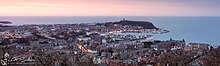
Tourism is a significant contributor to the economy. A study of visitors between 2013 and 2015 indicated that the Borough of Scarborough, including Filey, Whitby and parts of the North York Moors National Park, received 1.4m trips per year on average.[33] A 2016 report by the National Park, states the park area gets 7.93 million visitors annually, generating £647 million and supporting 10,900 full-time equivalent jobs.[34]
The Yorkshire Dales have also attracted many visitors. In 2016, there were 3.8 million visits to the National Park including 0.48 million who stayed at least one night. The parks service estimates that this contributed
£252 million to the economy and provided 3,583 full-time equivalent jobs. The wider Yorkshire Dales area received 9.7 million visitors who contributed £644 million to the economy.[35] The North York Moors and Yorkshire Dales are among England's best known destinations.[36]
The Shambles, a popular tourist area in York
York is a popular tourist destination. A 2014 report, based on 2012 data, stated that York alone receives 6.9 million visitors annually; they contribute £564 million to the economy and support over 19,000 jobs.[37] In the 2017
Condé Nast Traveller survey of readers, York rated 12th among The 15 Best Cities in the UK for visitors.[38] In a 2020 Condé Nast Traveller report, York rated as the sixth best among ten "urban destinations [in the UK] that scored the highest marks when it comes to ... nightlife, restaurants and friendliness".[39]
During February 2020 to January 2021, the average property in North Yorkshire county sold for £240,000, up by £8100 over the previous 12 months. By comparison, the average for England and Wales was £314,000.[40] In certain communities of North Yorkshire, however, house prices were higher than average for the county, as of early 2021: Harrogate (average value: £376,195), Knaresborough (£375,625), Tadcaster (£314,278), Leyburn (£309,165) and Ripon (£299,998), for example.[41]
This is a chart of trend of regional gross value added for North Yorkshire at current basic prices with figures in millions of British pounds sterling.[42]
This section needs to be updated. Please help update this article to reflect recent events or newly available information.(January 2023)
Unemployment in the county was traditionally low in recent years, but the lockdowns and travel restrictions necessitated by the
COVID-19 pandemic had a negative effect on the economy during much of 2020 and into 2021.[43] The UK government said in early February 2021 that it was planning "unprecedented levels of support to help businesses [in the UK] survive the crisis".[44] A report published on 1 March 2021 stated that the unemployment rate in North Yorkshire had "risen to the highest level in nearly 5 years – with under 25s often bearing the worst of job losses".[45]
York experienced high unemployment during lockdown periods. One analysis (by the York and North Yorkshire Local Enterprise Partnership) predicted in August 2020 that "as many as 13,835 jobs in York will be lost in the scenario considered most likely, taking the city's unemployment rate to 14.5%". Some critics claimed that part of the problem was caused by "over-reliance on the booming tourism industry at the expense of a long-term economic plan".[46] A report in mid June 2020 stated that unemployment had risen 114 per cent over the previous year because of restrictions imposed as a result of the pandemic.[47]
Tourism in the county was expected to increase after the restrictions imposed due the pandemic are relaxed. One reason for the expected increase is the airing of All Creatures Great and Small, a TV series about the vet
James Herriot, based on a successful series of books; it was largely filmed within the Yorkshire Dales National Park.[48] The show aired in the UK in September 2020 and in the US in early 2021. One source stated that visits to Yorkshire websites had increased significantly by late September 2020.[49]
North Yorkshire has a number of bridge with clusters such as
bridges of York or in the Tees Lowlands, over the
River Tees. Many are road bridges, railway viaducts or footbridges; such Lendal Bridge in York,
Saltburn Viaduct and the
Infinity Bridge respectively.
Larpool Viaduct near Whitby is a repurposed railway viaduct (footbridge), the viaduct was affected by the
Beeching cuts in 1965 with the rail-line connecting
Whitby to
Scarborough axed. It was opened in 1885, closed in 1965 then repurposed and re-opened in 2000.[52]
LNER and Grand Central operate services to the capital on the ECML, Leeds Branch Line and the
Northallerton–Eaglescliffe Line. LNER stop at York, Northallerton and on to County Durham or spur over to the
Tees Valley Line for
Thornaby and
Middlesbrough. The operator also branch before the county for Leeds and run to
Harrogate and
Skipton. Grand Central stop at York,
Thirsk Northallerton and Eaglescliffe then over to the
Durham Coast Line in County Durham.
York railway station is the largest station in the county, with 11 platforms and is a major tourist attraction in its own right. The station is immediately adjacent to the
National Railway Museum.
The main road through the county is the north–south
A1(M), which has gradually been upgraded in sections to motorway status since the early 1990s. The only other motorways within the county are the short
A66(M) near
Darlington and a small stretch of the
M62 motorway close to
Eggborough.[53] The other nationally maintained trunk routes are the
A168/
A19,
A64,
A66 and
A174.
Harrogate is also a popular tourist destination, famous for its
Turkish Baths,
gastronomy and high-end shops. The picture is of Victoria Gardens Shopping Centre.
^"Regional Gross Value Added"(PDF). Office for National Statistics. 21 December 2005. pp. 240–253. Archived from
the original(PDF) on 1 December 2007. Retrieved 6 October 2008.
The county is the largest in England by land area, at 8,654 km2 (3,480 sq mi), and had a population of 1,158,816 in 2021. The largest settlements are Middlesbrough (148,215) in the north-east and the city of
York (141,685) in the south. Middlesbrough is part of the
Teesside built-up area, which extends into County Durham and has a total population of 376,663 in 2011. The remainder of the county is rural, and the largest towns are
Harrogate (75,515) and
Scarborough (59,505). For
local government purposes the county comprises four
unitary authority areas —
Middlesbrough,
North Yorkshire,
Redcar and Cleveland, and
York — and part of a fifth,
Stockton-on-Tees. The local authorities of
York and North Yorkshire are part of a
combined authority of the same name, and the local authorities of the other three areas are part of the
Tees Valley combined authority. The county was historically part of
Yorkshire.
The centre of the county contains a wide plain, called the
Vale of Mowbray in the north and
Vale of York in the south. The
North York Moors uplands lie to the east, and south of them the
Vale of Pickering is separated from the main plain by the
Howardian Hills. The west of the county contains the
Yorkshire Dales, an extensive upland area which contains the source of the
River Ouse/
Ure and many of its tributaries, which together drain most of the county before reaching the
Humber estuary in the south. The Dales also contain the county's highest point,
Whernside, at 2,415 feet (736 m).[3]
Some areas which were part of the former
North Riding were in the county of
Cleveland for twenty-two years (from 1974 to 1996) and were placed in the North East region from 1993. On 1 April 1996, these areas (
Middlesbrough,
Redcar and Cleveland and
Stockton borough south of the
River Tees) became part of the ceremonial county as separate unitary authorities. These areas remain within the North East England region.
Also on 1 April 1996, the City of York non-metropolitan district and parts of the non-metropolitan county (
Haxby and nearby rural areas) became the
City of Yorkunitary authority.[5]
On 1 April 2023, the non-metropolitan county became a unitary authority. This abolished eight councils and extended the powers of the county council to act as a district council.[6]
North Yorkshire contains several major rivers. The
River Tees is the most northerly, forming part of the border between North Yorkshire and County Durham in its lower reaches and flowing east through
Teesdale before reaching the North Sea near Redcar. The Yorkshire Dales are the source of many of the county's major rivers, including the
Aire,
Lune,
Ribble,
Swale,
Ure, and
Wharfe.[11] The Aire, Swale, and Wharfe are tributaries of the Ure/Ouse, which at 208 km (129 mi) long is the sixth-longest river in the United Kingdom. The river is called the Ure until it meets Ouse Gill beck just below the village of Great Ouseburn, where it becomes the Ouse and flows south before exiting the county near Goole and entering the
Humber estuary.[12][13] The North York Moors are the catchment for a number of rivers: the
Leven which flows north into the Tees between Yarm and Ingleby Barwick; the
Esk flows east directly into the North Sea at Whitby as well as the
Rye (which later becomes the
Derwent at Malton) flows south into the River Ouse at Goole.[14]
North Yorkshire contains a small section of
green belt in the south of the county, which surrounds the neighbouring metropolitan area of Leeds along the North and West Yorkshire borders. It extends to the east to cover small communities such as
Huby,
Kirkby Overblow, and
Follifoot before covering the gap between the towns of Harrogate and Knaresborough, helping to keep those towns separate.
The belt adjoins the southernmost part of the
Yorkshire Dales National Park, and the
Nidderdale AONB. It extends into the western area of Selby district, reaching as far as Tadcaster and
Balne. The belt was first drawn up from the 1950s.
The city of York has an independent surrounding belt area affording protections to several outlying settlements such as Haxby and Dunnington, and it too extends into the surrounding districts.
Climate
North Yorkshire has a
temperateoceanic climate, like most of the UK. There are large climate variations within the county. The upper
Pennines border on a
Subarctic climate. The
Vale of Mowbray has an almost
Semi-arid climate. Overall, with the county being situated in the east, it receives below-average rainfall for the UK. Inside North Yorkshire, the upper Dales of the Pennines are one of the wettest parts of England, where in contrast the driest parts of the Vale of Mowbray are some of the driest areas in the UK.[15]
Summer temperatures are above average, at 22 °C. Highs can regularly reach up to 28 °C, with over 30 °C reached in
heat waves. Winter temperatures are below average, with average lows of 1 °C. Snow and Fog can be expected depending on location. The
North York Moors and
Pennines have snow lying for an average of between 45 and 75 days per year.[16] Sunshine is most plentiful on the coast, receiving an average of 1,650 hours a year. It reduces further west in the county, with the
Pennines receiving 1,250 hours a year.
In large areas of North Yorkshire, agriculture is the primary source of employment. Approximately 85% of the county is considered to be "rural or super sparse".[29]
Other sectors in 2019 included some manufacturing, the provision of accommodation and meals (primarily for tourists) which accounted for 19 per cent of all jobs. Food manufacturing employed 11 per cent of workers. A few people are involved in forestry and fishing in 2019. The average weekly earnings in 2018 were £531. Some 15% of workers declared themselves as self-employed. One report in late 2020 stated that "North Yorkshire has a relatively healthy and diverse economy which largely mirrors the national picture in terms of productivity and jobs.[30][31]
The
Teesport sea port handled over 53 million tonnes of cargo in 2013Drax Power Station has the highest generating capacity of any power station in the UK
Mineral extraction and power generation are also sectors of the economy, as is high technology.[32]
Tourism is a significant contributor to the economy. A study of visitors between 2013 and 2015 indicated that the Borough of Scarborough, including Filey, Whitby and parts of the North York Moors National Park, received 1.4m trips per year on average.[33] A 2016 report by the National Park, states the park area gets 7.93 million visitors annually, generating £647 million and supporting 10,900 full-time equivalent jobs.[34]
The Yorkshire Dales have also attracted many visitors. In 2016, there were 3.8 million visits to the National Park including 0.48 million who stayed at least one night. The parks service estimates that this contributed
£252 million to the economy and provided 3,583 full-time equivalent jobs. The wider Yorkshire Dales area received 9.7 million visitors who contributed £644 million to the economy.[35] The North York Moors and Yorkshire Dales are among England's best known destinations.[36]
The Shambles, a popular tourist area in York
York is a popular tourist destination. A 2014 report, based on 2012 data, stated that York alone receives 6.9 million visitors annually; they contribute £564 million to the economy and support over 19,000 jobs.[37] In the 2017
Condé Nast Traveller survey of readers, York rated 12th among The 15 Best Cities in the UK for visitors.[38] In a 2020 Condé Nast Traveller report, York rated as the sixth best among ten "urban destinations [in the UK] that scored the highest marks when it comes to ... nightlife, restaurants and friendliness".[39]
During February 2020 to January 2021, the average property in North Yorkshire county sold for £240,000, up by £8100 over the previous 12 months. By comparison, the average for England and Wales was £314,000.[40] In certain communities of North Yorkshire, however, house prices were higher than average for the county, as of early 2021: Harrogate (average value: £376,195), Knaresborough (£375,625), Tadcaster (£314,278), Leyburn (£309,165) and Ripon (£299,998), for example.[41]
This is a chart of trend of regional gross value added for North Yorkshire at current basic prices with figures in millions of British pounds sterling.[42]
This section needs to be updated. Please help update this article to reflect recent events or newly available information.(January 2023)
Unemployment in the county was traditionally low in recent years, but the lockdowns and travel restrictions necessitated by the
COVID-19 pandemic had a negative effect on the economy during much of 2020 and into 2021.[43] The UK government said in early February 2021 that it was planning "unprecedented levels of support to help businesses [in the UK] survive the crisis".[44] A report published on 1 March 2021 stated that the unemployment rate in North Yorkshire had "risen to the highest level in nearly 5 years – with under 25s often bearing the worst of job losses".[45]
York experienced high unemployment during lockdown periods. One analysis (by the York and North Yorkshire Local Enterprise Partnership) predicted in August 2020 that "as many as 13,835 jobs in York will be lost in the scenario considered most likely, taking the city's unemployment rate to 14.5%". Some critics claimed that part of the problem was caused by "over-reliance on the booming tourism industry at the expense of a long-term economic plan".[46] A report in mid June 2020 stated that unemployment had risen 114 per cent over the previous year because of restrictions imposed as a result of the pandemic.[47]
Tourism in the county was expected to increase after the restrictions imposed due the pandemic are relaxed. One reason for the expected increase is the airing of All Creatures Great and Small, a TV series about the vet
James Herriot, based on a successful series of books; it was largely filmed within the Yorkshire Dales National Park.[48] The show aired in the UK in September 2020 and in the US in early 2021. One source stated that visits to Yorkshire websites had increased significantly by late September 2020.[49]
North Yorkshire has a number of bridge with clusters such as
bridges of York or in the Tees Lowlands, over the
River Tees. Many are road bridges, railway viaducts or footbridges; such Lendal Bridge in York,
Saltburn Viaduct and the
Infinity Bridge respectively.
Larpool Viaduct near Whitby is a repurposed railway viaduct (footbridge), the viaduct was affected by the
Beeching cuts in 1965 with the rail-line connecting
Whitby to
Scarborough axed. It was opened in 1885, closed in 1965 then repurposed and re-opened in 2000.[52]
LNER and Grand Central operate services to the capital on the ECML, Leeds Branch Line and the
Northallerton–Eaglescliffe Line. LNER stop at York, Northallerton and on to County Durham or spur over to the
Tees Valley Line for
Thornaby and
Middlesbrough. The operator also branch before the county for Leeds and run to
Harrogate and
Skipton. Grand Central stop at York,
Thirsk Northallerton and Eaglescliffe then over to the
Durham Coast Line in County Durham.
York railway station is the largest station in the county, with 11 platforms and is a major tourist attraction in its own right. The station is immediately adjacent to the
National Railway Museum.
The main road through the county is the north–south
A1(M), which has gradually been upgraded in sections to motorway status since the early 1990s. The only other motorways within the county are the short
A66(M) near
Darlington and a small stretch of the
M62 motorway close to
Eggborough.[53] The other nationally maintained trunk routes are the
A168/
A19,
A64,
A66 and
A174.
Harrogate is also a popular tourist destination, famous for its
Turkish Baths,
gastronomy and high-end shops. The picture is of Victoria Gardens Shopping Centre.
^"Regional Gross Value Added"(PDF). Office for National Statistics. 21 December 2005. pp. 240–253. Archived from
the original(PDF) on 1 December 2007. Retrieved 6 October 2008.


.jpg)
.jpg)


.jpg)


 White Scar Cave is a popular show cave in Chapel-le-Dale.
 Aysgarth Falls, a popular destination in the Yorkshire Dales National Park for hikers, can also be reached by a short walk from the main road.
 Harrogate is also a popular tourist destination, famous for its Turkish Baths, gastronomy and high-end shops. The picture is of Victoria Gardens Shopping Centre.
 Roseberry Topping in the North York Moors


_at_Dishforth.jpg)

.jpg)


 In terms of interior floor area, York Minster is the 3rd Largest Cathedral in the United Kingdom.
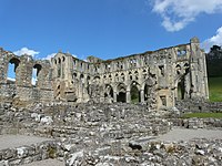
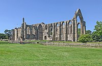
 With the first monastery built in the 7th century, the ruins of the medieval Whitby Abbey still stand today, now famous for its role in Dracula.


