Photos • Location
This article needs additional citations for
verification. (June 2019) |
Badhaadhe
Joore | |
|---|---|
 | |
| Coordinates: 1°02′00″S 41°29′47″E / 1.0332°S 41.4965°E | |
| Country | |
| Regional State | |
| Region | Lower Juba |
| Population | |
| • Total | 210,000 |
| Time zone | UTC+3 ( EAT) |
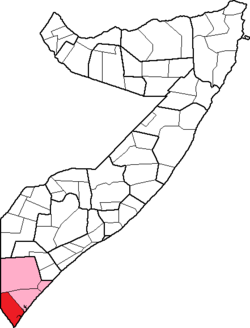
The Badhadhe District ( Somali: Degmada Badhaadhe) is a district in the southern Lower Jubba Region of Somalia. Badhaadhe consists of Ras Kamboni, Kolbiyow, Hosingo, Waldena, Bulla Haji and Kudhaa.
This article needs additional citations for
verification. (June 2019) |
Badhaadhe
Joore | |
|---|---|
 | |
| Coordinates: 1°02′00″S 41°29′47″E / 1.0332°S 41.4965°E | |
| Country | |
| Regional State | |
| Region | Lower Juba |
| Population | |
| • Total | 210,000 |
| Time zone | UTC+3 ( EAT) |
The Badhadhe District ( Somali: Degmada Badhaadhe) is a district in the southern Lower Jubba Region of Somalia. Badhaadhe consists of Ras Kamboni, Kolbiyow, Hosingo, Waldena, Bulla Haji and Kudhaa.