This article relies largely or entirely on a
single source. Relevant discussion may be found on the
talk page. Please help
improve this article by
introducing citations to additional sources. Find sources: "Araponga" – news · newspapers · books · scholar · JSTOR (January 2021) |

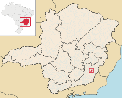
Araponga is a Brazilian municipality located in the state of Minas Gerais. Its population as of 2020 [update] is estimated to be 8,453 people living in an elevation of 1,040 meters. [1] The area of the municipality is 304.421 km². The city belongs to the mesoregion of Zona da Mata and to the microregion of Viçosa.
20°40′01″S 42°31′15″W / 20.66694°S 42.52083°W / -20.66694; -42.52083
|
| This geographical article relating to Minas Gerais is a stub. You can help Wikipedia by expanding it. |
- Pages using gadget WikiMiniAtlas
- Articles with short description
- Short description matches Wikidata
- Articles needing additional references from January 2021
- All articles needing additional references
- Articles containing potentially dated statements from 2020
- All articles containing potentially dated statements
- Coordinates on Wikidata
- All stub articles
This article relies largely or entirely on a
single source. Relevant discussion may be found on the
talk page. Please help
improve this article by
introducing citations to additional sources. Find sources: "Araponga" – news · newspapers · books · scholar · JSTOR (January 2021) |

Araponga is a Brazilian municipality located in the state of Minas Gerais. Its population as of 2020 [update] is estimated to be 8,453 people living in an elevation of 1,040 meters. [1] The area of the municipality is 304.421 km². The city belongs to the mesoregion of Zona da Mata and to the microregion of Viçosa.
20°40′01″S 42°31′15″W / 20.66694°S 42.52083°W / -20.66694; -42.52083
Capital:
Belo Horizonte | |||||||||||||||||||||||||
| |||||||||||||||||||||||||
| |||||||||||||||||||||||||
| |||||||||||||||||||||||||
| |||||||||||||||||||||||||
| |||||||||||||||||||||||||
| |||||||||||||||||||||||||
| |||||||||||||||||||||||||
| |||||||||||||||||||||||||
| |||||||||||||||||||||||||
| |||||||||||||||||||||||||
| |||||||||||||||||||||||||
| |||||||||||||||||||||||||
| |||||||||||||||||||||||||
|
| This geographical article relating to Minas Gerais is a stub. You can help Wikipedia by expanding it. |
- Pages using gadget WikiMiniAtlas
- Articles with short description
- Short description matches Wikidata
- Articles needing additional references from January 2021
- All articles needing additional references
- Articles containing potentially dated statements from 2020
- All articles containing potentially dated statements
- Coordinates on Wikidata
- All stub articles
