Photos • Location
Almamellék
Mamelik (in Croatian) Homeli (in German) | |
|---|---|
Village | |
 | |
| Coordinates: 46°09′42″N 17°52′45″E / 46.16157°N 17.87913°E | |
| Country | Hungary |
| Region | Southern Transdanubia |
| County | Baranya |
| District | Szigetvár |
| Area | |
| • Total | 44.33 km2 (17.12 sq mi) |
| Population (1 January 2023)
[1] | |
| • Total | 413 |
| • Density | 9.3/km2 (24/sq mi) |
| Time zone | UTC+1 ( CET) |
| • Summer ( DST) | UTC+2 ( CEST) |
| Postal code | 7934 |
| Area code | (+36) 73 |
| Website |
www |
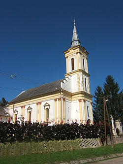
Almamellék ( German: Homeli) is a village in Baranya County, Hungary.
References
- ^ Error: Unable to display the reference properly. See the documentation for details.
External links
- Local statistics[ permanent dead link] (in Hungarian)
Almamellék
Mamelik (in Croatian) Homeli (in German) | |
|---|---|
Village | |
 | |
| Coordinates: 46°09′42″N 17°52′45″E / 46.16157°N 17.87913°E | |
| Country | Hungary |
| Region | Southern Transdanubia |
| County | Baranya |
| District | Szigetvár |
| Area | |
| • Total | 44.33 km2 (17.12 sq mi) |
| Population (1 January 2023)
[1] | |
| • Total | 413 |
| • Density | 9.3/km2 (24/sq mi) |
| Time zone | UTC+1 ( CET) |
| • Summer ( DST) | UTC+2 ( CEST) |
| Postal code | 7934 |
| Area code | (+36) 73 |
| Website |
www |
Almamellék ( German: Homeli) is a village in Baranya County, Hungary.
References
- ^ Error: Unable to display the reference properly. See the documentation for details.
External links
- Local statistics[ permanent dead link] (in Hungarian)


