33°53′32″N 35°29′54″E / 33.89222°N 35.49833°E

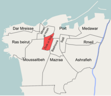
Zuqaq al-Blat ( Arabic: زقاق البلاط) is one of the twelve quarters of Beirut. [1]
Etymology
Zoqaq al-Blat literally means "the cobbled alley", this was a colloquial name given to the street extending from the old city to the Qantari hill and which was covered with cobblestones in the 19th century. [2]
Zuqaq al-Blat is also commonly called "al-Batrakieh" ( Arabic: البطركية, the Patriarchate) due to the presence of the seat of the Greek Catholic Patriarchate of Beirut within its borders. [3]
History
Once a medieval walled port town, Beirut experienced rapid growth during the second half of the 19th century; the overcrowded city developed beyond its walls and the affluent citizens started to build their villas on the slopes of the surrounding hills, namely Ashrafieh, Qnatari and Musaytbeh. [4] [5]
In 1832 Beirut came under the occupation of Ibrahim Pasha's troops. The new Egyptian authorities undertook grand works of urban planning and sanitation. The appointed Egyptian- Circassian governor of Beirut, Mahmoud Naami Bey commissioned street cobbling works which stretched beyond the city's walls, the street extending from the south-western side of the city wall into the new extramural neighborhoods on the Qantari hill came to be known as Zoqaq al-Blat and gave its name to the quarter. [2]
Notable residents
Some of the notable people resided in Zuqaq al-Blat included:
- Abd el-Qader Qabbani [6]
- Butrus Bustani [6]
- Fairuz
- Hussein Beyhum [6]
- Khalil Sarkis [6]
References
- ^ Hanssen, Jens (2005). Fin de Siècle Beirut: The Making of an Ottoman Provincial Capital. Oxford University Press. ISBN 0199281637. Archived from the original on 2023-08-17. Retrieved 2020-10-04.
- ^ a b Kassir, Samir (2006). تاريخ بيروت (in Arabic). Beirut: Dar An-Nahar. ISBN 9953741018.
- ^ زقاق البلاط (in Arabic). yabeyrouth.com. Archived from the original on October 22, 2012. Retrieved February 14, 2013.
- ^ Kihtir Öztürk, Pelin (September 2006). Urban transformation of Ottoman port cities in the nineteenth century: Change from Ottoman Beirut to French mandatory Beirut (PDF) (MA thesis). Middle East Technical University. Archived (PDF) from the original on 2014-02-02. Retrieved 2013-02-14.
- ^ Kassir, Samir; M. B. DeBevoise (2010). Beirut. University of California Press. ISBN 978-0520256682.
- ^ a b c d Speidl, Bianka (2011). "Distance in vicinity: Beirut's Zuqaq el-Blat, a place of transformation, conflict and co-existence". Études sur la Région Méditerranéenne. 20: 37. Archived from the original on 2023-04-29. Retrieved 2023-04-29.
33°53′32″N 35°29′54″E / 33.89222°N 35.49833°E

Zuqaq al-Blat ( Arabic: زقاق البلاط) is one of the twelve quarters of Beirut. [1]
Etymology
Zoqaq al-Blat literally means "the cobbled alley", this was a colloquial name given to the street extending from the old city to the Qantari hill and which was covered with cobblestones in the 19th century. [2]
Zuqaq al-Blat is also commonly called "al-Batrakieh" ( Arabic: البطركية, the Patriarchate) due to the presence of the seat of the Greek Catholic Patriarchate of Beirut within its borders. [3]
History
Once a medieval walled port town, Beirut experienced rapid growth during the second half of the 19th century; the overcrowded city developed beyond its walls and the affluent citizens started to build their villas on the slopes of the surrounding hills, namely Ashrafieh, Qnatari and Musaytbeh. [4] [5]
In 1832 Beirut came under the occupation of Ibrahim Pasha's troops. The new Egyptian authorities undertook grand works of urban planning and sanitation. The appointed Egyptian- Circassian governor of Beirut, Mahmoud Naami Bey commissioned street cobbling works which stretched beyond the city's walls, the street extending from the south-western side of the city wall into the new extramural neighborhoods on the Qantari hill came to be known as Zoqaq al-Blat and gave its name to the quarter. [2]
Notable residents
Some of the notable people resided in Zuqaq al-Blat included:
- Abd el-Qader Qabbani [6]
- Butrus Bustani [6]
- Fairuz
- Hussein Beyhum [6]
- Khalil Sarkis [6]
References
- ^ Hanssen, Jens (2005). Fin de Siècle Beirut: The Making of an Ottoman Provincial Capital. Oxford University Press. ISBN 0199281637. Archived from the original on 2023-08-17. Retrieved 2020-10-04.
- ^ a b Kassir, Samir (2006). تاريخ بيروت (in Arabic). Beirut: Dar An-Nahar. ISBN 9953741018.
- ^ زقاق البلاط (in Arabic). yabeyrouth.com. Archived from the original on October 22, 2012. Retrieved February 14, 2013.
- ^ Kihtir Öztürk, Pelin (September 2006). Urban transformation of Ottoman port cities in the nineteenth century: Change from Ottoman Beirut to French mandatory Beirut (PDF) (MA thesis). Middle East Technical University. Archived (PDF) from the original on 2014-02-02. Retrieved 2013-02-14.
- ^ Kassir, Samir; M. B. DeBevoise (2010). Beirut. University of California Press. ISBN 978-0520256682.
- ^ a b c d Speidl, Bianka (2011). "Distance in vicinity: Beirut's Zuqaq el-Blat, a place of transformation, conflict and co-existence". Études sur la Région Méditerranéenne. 20: 37. Archived from the original on 2023-04-29. Retrieved 2023-04-29.