Zuidwolde | |
|---|---|
 Windmill
De Vlijt, Zuidwolde | |
 Flag  Coat of arms | |
 Zuidwolde Location in province of
Drenthe in the
Netherlands  Zuidwolde Zuidwolde (Netherlands) | |
| Coordinates: 52°40′17″N 6°25′40″E / 52.67139°N 6.42778°E | |
| Country | Netherlands |
| Province | Drenthe |
| Municipality | De Wolden |
| Area | |
| • Total | 23.05 km2 (8.90 sq mi) |
| Elevation | 11 m (36 ft) |
| Population (2021)
[1] | |
| • Total | 6,385 |
| • Density | 280/km2 (720/sq mi) |
| Time zone | UTC+1 ( CET) |
| • Summer ( DST) | UTC+2 ( CEST) |
| Postal code | 7920, 7921
[1] |
| Dialing code | 0528 |
Zuidwolde is a village in the Dutch province of Drenthe. It is located in the municipality of De Wolden, about 7 km southwest of Hoogeveen. The village was integrated with Ruinen in 2008. [3]
Zuidwolde was a separate municipality until 1998, when it became part of De Wolden. [4]
Zuidwolde is the site of the De Vlijt, a windmill from the 1800s.
- Bart de Groot (born 1990), footballer [5]
- Henk Hulzebos (born 1950), equestrian [6]
- Wouter Marinus (born 1995), footballer [7]
- Jan Vayne (born 1966), pianist [8]
-
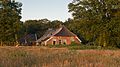 Farm in Zuidwolde
 -
 Sunset
 -
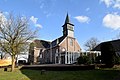 Protestant church
 -
 Two storks
.jpg)
.jpg)

.jpg)
- ^ a b c "Kerncijfers wijken en buurten 2021". Central Bureau of Statistics. Retrieved 12 March 2022.
- ^ "Postcodetool for 7921AA". Actueel Hoogtebestand Nederland (in Dutch). Het Waterschapshuis. Retrieved 12 March 2022.
- ^ Wolden/Ruinen, Drenthe – The New Integrated Municipality
- ^ Meer, Ad van der and Boonstra, Onno (2006). Repertorium van Nederlandse gemeenten. KNAW. "KNAW > Publicaties > Detailpagina". Archived from the original on 20 February 2007. Retrieved 3 December 2009.
- ^ "FC Emmen-speler Bart de Groot naar Vietnam". RTV Drenthe (in Dutch). 18 November 2013. Retrieved 12 March 2022.
- ^ "Henk Hulzebos". Sports Reference. Archived from the original on 18 April 2020. Retrieved 12 March 2022.
- ^ "Wouter Marinus". World Football (in Dutch). Retrieved 12 March 2022.
- ^ "Jan Vayne". Muziekencyclopedie (in Dutch). Retrieved 12 March 2022.
|
| This Drenthe location article is a stub. You can help Wikipedia by expanding it. |
Zuidwolde | |
|---|---|
|
Windmill
De Vlijt, Zuidwolde | |
|
Flag Coat of arms | |
Zuidwolde Location in province of
Drenthe in the
Netherlands Zuidwolde Zuidwolde (Netherlands) | |
| Coordinates: 52°40′17″N 6°25′40″E / 52.67139°N 6.42778°E | |
| Country | Netherlands |
| Province | Drenthe |
| Municipality | De Wolden |
| Area | |
| • Total | 23.05 km2 (8.90 sq mi) |
| Elevation | 11 m (36 ft) |
| Population (2021)
[1] | |
| • Total | 6,385 |
| • Density | 280/km2 (720/sq mi) |
| Time zone | UTC+1 ( CET) |
| • Summer ( DST) | UTC+2 ( CEST) |
| Postal code | 7920, 7921
[1] |
| Dialing code | 0528 |
Zuidwolde is a village in the Dutch province of Drenthe. It is located in the municipality of De Wolden, about 7 km southwest of Hoogeveen. The village was integrated with Ruinen in 2008. [3]
Zuidwolde was a separate municipality until 1998, when it became part of De Wolden. [4]
Zuidwolde is the site of the De Vlijt, a windmill from the 1800s.
- Bart de Groot (born 1990), footballer [5]
- Henk Hulzebos (born 1950), equestrian [6]
- Wouter Marinus (born 1995), footballer [7]
- Jan Vayne (born 1966), pianist [8]
-
Farm in Zuidwolde
-
Sunset
-
Protestant church
-
Two storks
- ^ a b c "Kerncijfers wijken en buurten 2021". Central Bureau of Statistics. Retrieved 12 March 2022.
- ^ "Postcodetool for 7921AA". Actueel Hoogtebestand Nederland (in Dutch). Het Waterschapshuis. Retrieved 12 March 2022.
- ^ Wolden/Ruinen, Drenthe – The New Integrated Municipality
- ^ Meer, Ad van der and Boonstra, Onno (2006). Repertorium van Nederlandse gemeenten. KNAW. "KNAW > Publicaties > Detailpagina". Archived from the original on 20 February 2007. Retrieved 3 December 2009.
- ^ "FC Emmen-speler Bart de Groot naar Vietnam". RTV Drenthe (in Dutch). 18 November 2013. Retrieved 12 March 2022.
- ^ "Henk Hulzebos". Sports Reference. Archived from the original on 18 April 2020. Retrieved 12 March 2022.
- ^ "Wouter Marinus". World Football (in Dutch). Retrieved 12 March 2022.
- ^ "Jan Vayne". Muziekencyclopedie (in Dutch). Retrieved 12 March 2022.
|
| This Drenthe location article is a stub. You can help Wikipedia by expanding it. |