| Zombor District | |||||||||
|---|---|---|---|---|---|---|---|---|---|
| District of the Voivodeship of Serbia and Temes Banat | |||||||||
| 1850–1860 | |||||||||
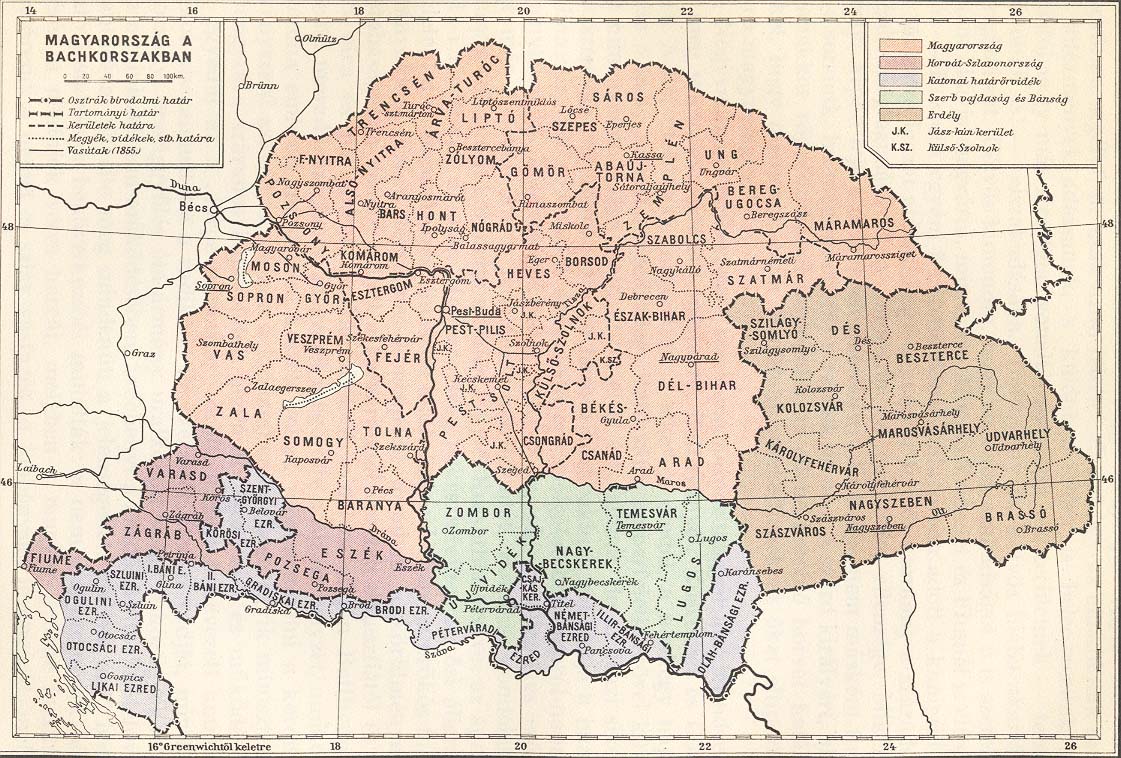
 Districts of the Voivodeship of Serbia and Banat of Temeschwar; Zombor District is shown in red | |||||||||
| Capital | Zombor (Serbian: Sombor) | ||||||||
| History | |||||||||
• Established | 1850 | ||||||||
• Disestablished | 1860 | ||||||||
| |||||||||
| Today part of | Serbia, Hungary | ||||||||
Zombor District ( Serbian: Сомборски округ, Somborski okrug; German: Zambórer Distrikt, [1] Kreis Zombor [2] from 1853; Hungarian: Zombori körzet; Bunjevac: Somborski okrug) was one of five administrative districts (originally Districte, modern spelling Distrikte; Kreise, lit. ' circles', from 1853) of the Voivodeship of Serbia and Temes Banat (a crown land within Austrian Empire) from 1850 to 1860. Its administrative center was Zombor (Serbian: Sombor).
History
The crown land Voivodeship of Serbia and Temes Banat was formed in 1849 and was initially divided into two districts: Batschka-Torontal and Temeschwar-Karasch. In 1850, crown land was divided into five districts and the territory of Batschka-Torontal District was divided among Neusatz District, Zombor District and Großbetschkerek District.
In German the original term used for these subdivisions was Districte [1] (modern spelling Distrikte). In 1851 they were divided into subdivisions called (politische) Bezirke, [1] usually translated as '(political) districts'.
In Bach's reforms from 1853 the Districte became Kreise, [3] a form of administrative division already in use across much of the non-Hungarian part of the Empire since the 18th century. The term Kreis, literally ' circle', is also often translated as 'district'. The subdivisions of the Kreise were also called Bezirke in German, or Amtsbezirke ('office districts', in reference to the Bezirks ämter or 'district offices' which ran them) to distinguish them from other types of Bezirk. The change of name was not superficial – different political, administrative and judicial structures were used in each subdivision type. (See also Districts of Austria § Habsburg Monarchy and Austrian Empire.)
In 1860, the Voivodeship of Serbia and Temes Banat and its five districts were abolished and the territory of the Zombor District was administratively included into the Batsch-Bodrog County (part of the Austrian Kingdom of Hungary).
Geography
The Zombor District included northern parts of Bačka. It shared borders with the Neusatz District in the south, Großbetschkerek District in the east, Austrian Kingdom of Slavonia in the south-west, and Austrian Kingdom of Hungary in the north-west.
Demographics
According to 1850 census, the population of the Zombor district numbered 376,366 residents, including: [4]
- Hungarians = 160,016 (42.52%)
- Germans = 103,886 (27.6%)
- Bunjevci = 53,908 (14.32%)
- Serbs = 40,054 (10.64%)
- Jews = 7,830 (2.08%)
Subdivisions
In 1851 Zombor District was subdivided into 4 political districts (politische Bezirke), which were structurally akin to the modern districts of Austria: [1]
The cities of Zombór (Sombor) and Theresiopel (Subotica) were separate from the political districts; the districts which carried their names covered the areas around the cities, which acted as their seats/capitals [1] (i.e. they were statutory cities).
In 1854 Zombor District (now a Kreis) was subdivided into 6 'office districts' ( Amtsbezirke): [2]
Cities and towns
Main cities and towns in the district were:
- Abthausen (Apatin)
- Ada an der Theiß (Ada)
- Almasch (Almás)
- Alt-Kanischa (Stara Kanjiža)
- Batschka Topola (Bačka Topola)
- Frankenstadt (Baja)
- Jankovatz (Jankovácz)
- Josephsfeld (Kula)
- Maria-Theresiopel (Subotica)
- Zenta (Senta)
- Zombor (Sombor)
Most of the mentioned cities and towns are today in Serbia, while towns of Frankenstadt (Baja), Almasch (Almás) and Jankovatz (Jankovácz) are today in Hungary.
References
- ^ a b c d e Gesetz vom 17. August 1851, 192/1851: "Verordnung des Ministeriums des Innern, womit die durch Allerhöchste Entschließung sanctionirte Organisation der politischen Verwaltung der Woiwodschaft Serbien und des Temeser Banates kundgemacht wird". Reichs-Gesetz-Blatt für das Kaiserthum Österreich (in German). 1851-08-17. Retrieved 2023-07-13 – via ÖNB-ALEX - Historische Rechts- und Gesetztexte Online.
- ^ a b Gesetz vom 1. Februar 1854, RGBl. 28/1854: "Verordnung der Minister des Inneren, der Justiz und der Finanzen vom 1. Februar 1854, betreffend die politische und gerichtliche Organisirung der serbischen Woiwodschaft und des Temeser Banates". Reichs-Gesetz-Blatt für das Kaiserthum Österreich (in German). 1854-02-01. Retrieved 2023-07-04 – via ÖNB-ALEX - Historische Rechts- und Gesetztexte Online.
- ^ Gesetz vom 19. Jänner 1853, RGBl. 10/1853: "Verordnung der Minister des Inneren, der Justiz und der Finanzen vom 19. Jänner 1853, womit die Allerhöchsten Entschließungen über die Einrichtung und Amtswirksamkeit der Bezirksämter, Kreisbehörden und Statthaltereien, über die Einrichtung der Gerichtsstellen und das Schema der systemisirten Gehalte und Diätenclassen, sowie über die Ausführung der Organisirung für die Kronländer Oesterreich ob und unter der Enns, Böhmen, Mähren, Schlesien, Galizien und Lodomerien mit Krakau, Bukowina, Salzburg, Tirol mit Vorarlberg, Steiermark, Kärnthen, Krain, Görz, Gradiska und Istrien mit Triest, Dalmatien, Kroatien und Slawonien, Siebenbürgen, die serbische Wojwodschaft mit dem Banate, kundgemacht werden". ÖNB-ALEX - Historische Rechts- und Gesetztexte Online (in German). 1853-01-19. Retrieved 2023-07-13.
- ^ Dr Saša Kicošev - Dr Drago Njegovan, Razvoj etničke i verske strukture Vojvodine, Novi Sad, 2010, page 19.
Further reading
- Dr Saša Kicošev - Dr Drago Njegovan, Razvoj etničke i verske strukture Vojvodine, Novi Sad, 2010.
- Dr Drago Njegovan, Prisajedinjenje Vojvodine Srbiji, Novi Sad, 2004.
See also
External links
| 1849-1850 | |
|---|---|
| 1850-1860 | |
| Zombor District | |||||||||
|---|---|---|---|---|---|---|---|---|---|
| District of the Voivodeship of Serbia and Temes Banat | |||||||||
| 1850–1860 | |||||||||
|
Districts of the Voivodeship of Serbia and Banat of Temeschwar; Zombor District is shown in red | |||||||||
| Capital | Zombor (Serbian: Sombor) | ||||||||
| History | |||||||||
• Established | 1850 | ||||||||
• Disestablished | 1860 | ||||||||
| |||||||||
| Today part of | Serbia, Hungary | ||||||||
Zombor District ( Serbian: Сомборски округ, Somborski okrug; German: Zambórer Distrikt, [1] Kreis Zombor [2] from 1853; Hungarian: Zombori körzet; Bunjevac: Somborski okrug) was one of five administrative districts (originally Districte, modern spelling Distrikte; Kreise, lit. ' circles', from 1853) of the Voivodeship of Serbia and Temes Banat (a crown land within Austrian Empire) from 1850 to 1860. Its administrative center was Zombor (Serbian: Sombor).
History
The crown land Voivodeship of Serbia and Temes Banat was formed in 1849 and was initially divided into two districts: Batschka-Torontal and Temeschwar-Karasch. In 1850, crown land was divided into five districts and the territory of Batschka-Torontal District was divided among Neusatz District, Zombor District and Großbetschkerek District.
In German the original term used for these subdivisions was Districte [1] (modern spelling Distrikte). In 1851 they were divided into subdivisions called (politische) Bezirke, [1] usually translated as '(political) districts'.
In Bach's reforms from 1853 the Districte became Kreise, [3] a form of administrative division already in use across much of the non-Hungarian part of the Empire since the 18th century. The term Kreis, literally ' circle', is also often translated as 'district'. The subdivisions of the Kreise were also called Bezirke in German, or Amtsbezirke ('office districts', in reference to the Bezirks ämter or 'district offices' which ran them) to distinguish them from other types of Bezirk. The change of name was not superficial – different political, administrative and judicial structures were used in each subdivision type. (See also Districts of Austria § Habsburg Monarchy and Austrian Empire.)
In 1860, the Voivodeship of Serbia and Temes Banat and its five districts were abolished and the territory of the Zombor District was administratively included into the Batsch-Bodrog County (part of the Austrian Kingdom of Hungary).
Geography
The Zombor District included northern parts of Bačka. It shared borders with the Neusatz District in the south, Großbetschkerek District in the east, Austrian Kingdom of Slavonia in the south-west, and Austrian Kingdom of Hungary in the north-west.
Demographics
According to 1850 census, the population of the Zombor district numbered 376,366 residents, including: [4]
- Hungarians = 160,016 (42.52%)
- Germans = 103,886 (27.6%)
- Bunjevci = 53,908 (14.32%)
- Serbs = 40,054 (10.64%)
- Jews = 7,830 (2.08%)
Subdivisions
In 1851 Zombor District was subdivided into 4 political districts (politische Bezirke), which were structurally akin to the modern districts of Austria: [1]
The cities of Zombór (Sombor) and Theresiopel (Subotica) were separate from the political districts; the districts which carried their names covered the areas around the cities, which acted as their seats/capitals [1] (i.e. they were statutory cities).
In 1854 Zombor District (now a Kreis) was subdivided into 6 'office districts' ( Amtsbezirke): [2]
Cities and towns
Main cities and towns in the district were:
- Abthausen (Apatin)
- Ada an der Theiß (Ada)
- Almasch (Almás)
- Alt-Kanischa (Stara Kanjiža)
- Batschka Topola (Bačka Topola)
- Frankenstadt (Baja)
- Jankovatz (Jankovácz)
- Josephsfeld (Kula)
- Maria-Theresiopel (Subotica)
- Zenta (Senta)
- Zombor (Sombor)
Most of the mentioned cities and towns are today in Serbia, while towns of Frankenstadt (Baja), Almasch (Almás) and Jankovatz (Jankovácz) are today in Hungary.
References
- ^ a b c d e Gesetz vom 17. August 1851, 192/1851: "Verordnung des Ministeriums des Innern, womit die durch Allerhöchste Entschließung sanctionirte Organisation der politischen Verwaltung der Woiwodschaft Serbien und des Temeser Banates kundgemacht wird". Reichs-Gesetz-Blatt für das Kaiserthum Österreich (in German). 1851-08-17. Retrieved 2023-07-13 – via ÖNB-ALEX - Historische Rechts- und Gesetztexte Online.
- ^ a b Gesetz vom 1. Februar 1854, RGBl. 28/1854: "Verordnung der Minister des Inneren, der Justiz und der Finanzen vom 1. Februar 1854, betreffend die politische und gerichtliche Organisirung der serbischen Woiwodschaft und des Temeser Banates". Reichs-Gesetz-Blatt für das Kaiserthum Österreich (in German). 1854-02-01. Retrieved 2023-07-04 – via ÖNB-ALEX - Historische Rechts- und Gesetztexte Online.
- ^ Gesetz vom 19. Jänner 1853, RGBl. 10/1853: "Verordnung der Minister des Inneren, der Justiz und der Finanzen vom 19. Jänner 1853, womit die Allerhöchsten Entschließungen über die Einrichtung und Amtswirksamkeit der Bezirksämter, Kreisbehörden und Statthaltereien, über die Einrichtung der Gerichtsstellen und das Schema der systemisirten Gehalte und Diätenclassen, sowie über die Ausführung der Organisirung für die Kronländer Oesterreich ob und unter der Enns, Böhmen, Mähren, Schlesien, Galizien und Lodomerien mit Krakau, Bukowina, Salzburg, Tirol mit Vorarlberg, Steiermark, Kärnthen, Krain, Görz, Gradiska und Istrien mit Triest, Dalmatien, Kroatien und Slawonien, Siebenbürgen, die serbische Wojwodschaft mit dem Banate, kundgemacht werden". ÖNB-ALEX - Historische Rechts- und Gesetztexte Online (in German). 1853-01-19. Retrieved 2023-07-13.
- ^ Dr Saša Kicošev - Dr Drago Njegovan, Razvoj etničke i verske strukture Vojvodine, Novi Sad, 2010, page 19.
Further reading
- Dr Saša Kicošev - Dr Drago Njegovan, Razvoj etničke i verske strukture Vojvodine, Novi Sad, 2010.
- Dr Drago Njegovan, Prisajedinjenje Vojvodine Srbiji, Novi Sad, 2004.
See also
External links
| 1849-1850 | |
|---|---|
| 1850-1860 | |