From Wikipedia, the free encyclopedia
Sub-prefectures in Central African Republic
Zangba is a
sub-prefecture of
Basse-Kotto in the
Central African Republic.
[1]
[2]
Geography
The locality is located on the right bank of the Ubangi River which is the border with Congo DRC.
History
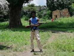 UPC fighter in Zangba, September 2019
As of May 2021 Zangba remains under control of
Union for Peace in the Central African Republic rebel group.
[3]
Administration
The sub-prefecture of Zangba is made up of the two communes of Ouambé and Yabongo.
References
|
|---|
| Equateur Region | | |
|---|
| Fertit Region | |
|---|
| Haut-Oubangui Region | |
|---|
| Kagas Region | |
|---|
| Plateaux Region | |
|---|
| Yade Region | |
|---|
4°27′N 20°59′E / 4.450°N 20.983°E / 4.450; 20.983


