Photos • Location
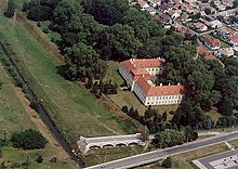
Aerial view of Zalaszentgrót


Zalaszentgrót | |
|---|---|
 Flag  Coat of arms | |
 Zalaszentgrót Location of Zalaszentgrót | |
| Coordinates: 46°56′25″N 17°04′53″E / 46.94040°N 17.08138°E | |
| Country | |
| County | Zala County |
| Area | |
| • Total | 81.62 km2 (31.51 sq mi) |
| Population (2019) | |
| • Total | 6,172 |
| • Density | 76/km2 (200/sq mi) |
| Time zone | UTC+1 ( CET) |
| • Summer ( DST) | UTC+2 ( CEST) |
| Postal code | 8790 |
| Area code | 83 |
Zalaszentgrót is a town in Zala County, Hungary. The settlement incorporates the suburbs Kisszentgrót, Tüskeszentpéter, Csáford, Zalakoppány, Zalaudvarnok and Aranyod.
Twin towns – sister cities

Zalaszentgrót is twinned with:
-
 Germersheim, Germany
External links
Wikimedia Commons has media related to
Zalaszentgrót.
Wikivoyage has a travel guide for
Zalaszentgrót.
- Street map (in Hungarian)
- [1]
- [2]

.svg)
| International | |
|---|---|
| National | |
|
| This Zala location article is a stub. You can help Wikipedia by expanding it. |
Zalaszentgrót | |
|---|---|
|
Flag Coat of arms | |
Zalaszentgrót Location of Zalaszentgrót | |
| Coordinates: 46°56′25″N 17°04′53″E / 46.94040°N 17.08138°E | |
| Country | |
| County | Zala County |
| Area | |
| • Total | 81.62 km2 (31.51 sq mi) |
| Population (2019) | |
| • Total | 6,172 |
| • Density | 76/km2 (200/sq mi) |
| Time zone | UTC+1 ( CET) |
| • Summer ( DST) | UTC+2 ( CEST) |
| Postal code | 8790 |
| Area code | 83 |
Zalaszentgrót is a town in Zala County, Hungary. The settlement incorporates the suburbs Kisszentgrót, Tüskeszentpéter, Csáford, Zalakoppány, Zalaudvarnok and Aranyod.
Twin towns – sister cities
Zalaszentgrót is twinned with:
-
Germersheim, Germany
External links
Wikimedia Commons has media related to
Zalaszentgrót.
Wikivoyage has a travel guide for
Zalaszentgrót.
- Street map (in Hungarian)
- [1]
- [2]
| International | |
|---|---|
| National | |
|
| This Zala location article is a stub. You can help Wikipedia by expanding it. |