Záchlumí | |
|---|---|
 Centre of Záchlumí | |
_vlajka.jpg) Flag _znak.jpg) Coat of arms | |
 Záchlumí Location in the Czech Republic | |
| Coordinates: 49°48′0″N 12°57′54″E / 49.80000°N 12.96500°E | |
| Country | |
| Region | Plzeň |
| District | Tachov |
| First mentioned | 1359 |
| Area | |
| • Total | 4.42 km2 (1.71 sq mi) |
| Elevation | 497 m (1,631 ft) |
| Population (2023-01-01)
[1] | |
| • Total | 450 |
| • Density | 100/km2 (260/sq mi) |
| Time zone | UTC+1 ( CET) |
| • Summer ( DST) | UTC+2 ( CEST) |
| Postal code | 349 01 |
| Website |
www |
Záchlumí ( German: Eisenhuttel) is a municipality and village in Tachov District in the Plzeň Region of the Czech Republic. It has about 500 inhabitants.
Záchlumí lies approximately 25 kilometres (16 mi) east of Tachov, 31 km (19 mi) west of Plzeň, and 110 km (68 mi) west of Prague.
Demographics
| Year | Pop. | ±% |
|---|---|---|
| 1869 | 201 | — |
| 1880 | 177 | −11.9% |
| 1890 | 190 | +7.3% |
| 1900 | 205 | +7.9% |
| 1910 | 191 | −6.8% |
| 1921 | 190 | −0.5% |
| 1930 | 214 | +12.6% |
| 1950 | 111 | −48.1% |
| 1961 | 203 | +82.9% |
| 1970 | 207 | +2.0% |
| 1980 | 322 | +55.6% |
| 1991 | 403 | +25.2% |
| 2001 | 421 | +4.5% |
| 2011 | 360 | −14.5% |
| 2021 | 398 | +10.6% |
| Source: Censuses [2] [3] | ||
Gallery
-
 Middle part
 -
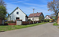
 Tenement houses
 -
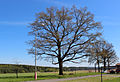 Old oak – protected tree


References
- ^ "Population of Municipalities – 1 January 2023". Czech Statistical Office. 2023-05-23.
- ^ "Historický lexikon obcí České republiky 1869–2011 – Okres Tachov" (in Czech). Czech Statistical Office. 2015-12-21. pp. 19–20.
- ^ "Population Census 2021: Population by sex". Public Database. Czech Statistical Office. 2021-03-27.
External links
| Authority control databases: National |
|---|
|
| This Plzeň Region location article is a stub. You can help Wikipedia by expanding it. |
Záchlumí | |
|---|---|
|
Centre of Záchlumí | |
|
Flag Coat of arms | |
Záchlumí Location in the Czech Republic | |
| Coordinates: 49°48′0″N 12°57′54″E / 49.80000°N 12.96500°E | |
| Country | |
| Region | Plzeň |
| District | Tachov |
| First mentioned | 1359 |
| Area | |
| • Total | 4.42 km2 (1.71 sq mi) |
| Elevation | 497 m (1,631 ft) |
| Population (2023-01-01)
[1] | |
| • Total | 450 |
| • Density | 100/km2 (260/sq mi) |
| Time zone | UTC+1 ( CET) |
| • Summer ( DST) | UTC+2 ( CEST) |
| Postal code | 349 01 |
| Website |
www |
Záchlumí ( German: Eisenhuttel) is a municipality and village in Tachov District in the Plzeň Region of the Czech Republic. It has about 500 inhabitants.
Záchlumí lies approximately 25 kilometres (16 mi) east of Tachov, 31 km (19 mi) west of Plzeň, and 110 km (68 mi) west of Prague.
Demographics
| Year | Pop. | ±% |
|---|---|---|
| 1869 | 201 | — |
| 1880 | 177 | −11.9% |
| 1890 | 190 | +7.3% |
| 1900 | 205 | +7.9% |
| 1910 | 191 | −6.8% |
| 1921 | 190 | −0.5% |
| 1930 | 214 | +12.6% |
| 1950 | 111 | −48.1% |
| 1961 | 203 | +82.9% |
| 1970 | 207 | +2.0% |
| 1980 | 322 | +55.6% |
| 1991 | 403 | +25.2% |
| 2001 | 421 | +4.5% |
| 2011 | 360 | −14.5% |
| 2021 | 398 | +10.6% |
| Source: Censuses [2] [3] | ||
Gallery
-
Middle part
-
Tenement houses
-
Old oak – protected tree
References
- ^ "Population of Municipalities – 1 January 2023". Czech Statistical Office. 2023-05-23.
- ^ "Historický lexikon obcí České republiky 1869–2011 – Okres Tachov" (in Czech). Czech Statistical Office. 2015-12-21. pp. 19–20.
- ^ "Population Census 2021: Population by sex". Public Database. Czech Statistical Office. 2021-03-27.
External links
| Authority control databases: National |
|---|
|
| This Plzeň Region location article is a stub. You can help Wikipedia by expanding it. |