You can help expand this article with text translated from
the corresponding article in French. (December 2011) Click [show] for important translation instructions.
|
| Ytre Hvaler National Park | |
|---|---|
IUCN category II (
national park) | |
|
| |
| Location | Hvaler, Norway |
| Nearest city | Fredrikstad |
| Coordinates | 59°N 11°E / 59°N 11°E |
| Area | 354 km2 (137 sq mi), of which 14 km2 (5.4 sq mi) is land 340 km2 (130 sq mi) is water |
| Established | 26 June 2009 |
| Governing body | Norwegian Directorate for Nature Management |
|
| |
Ytre Hvaler National Park (
Norwegian: Ytre Hvaler nasjonalpark, literally Outer Hvaler National Park) is a
national park located within the municipalities of
Hvaler and
Fredrikstad in
Østfold,
Norway. The park was established on 26 June 2009 and was the first national marine park in the country of Norway.
[1] The park manager is located in
Skjærhalden.
[2]
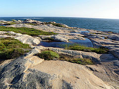
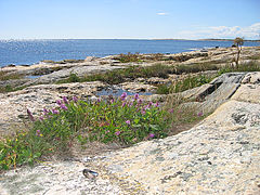
Ytre Hvaler is mostly a marine park, covering the outer parts of the skerries of the east shore of Oslofjord. To the south, the national park's boundaries lie on the Norway–Sweden border next to Kosterhavet National Park. Ytre Hvaler covers an area of 354 km2 (137 sq mi), of which 340 km2 (130 sq mi) is sea and 14 km2 (5 sq mi) is land. [3]
Settlements in the area may have been as old as the Bronze Age. The park is dominated by the coastal culture which has used the area for centuries, resulting in it including boathouses for fishing. Akerøya was settled between 1682 and 1807. There are more than 50 shipwrecks in the park, the most prominent being the Danish frigate HDMS Lossen which was lost during the Christmas Flood of 1717. [4]
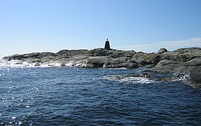
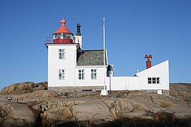
Within the park are two lighthouses: Torbjørnskjær and Homlungen, both of which are operated by the Norwegian Coastal Administration. The islands remain in use for grazing. [5] The park includes the Tisler Reef, a cold water coral reef, consisting mostly of Lophelia. [6] The Tisler Reef is the largest known coral reef in sheltered waters in Europe, and is located near the island of Tisler. [5]
Gallery
-
 Rødshue
 -
 Søsterøyene
 -
![Tisler[7]](https://upload.wikimedia.org/wikipedia/commons/thumb/2/26/Ytre_Hvaler%2C_Tisler_coast.jpg/270px-Ytre_Hvaler%2C_Tisler_coast.jpg)
-
![Herføl[8]](https://upload.wikimedia.org/wikipedia/commons/thumb/c/c0/Ytre_Hvaler%2C_Herf%C3%B8l_wave.jpg/240px-Ytre_Hvaler%2C_Herf%C3%B8l_wave.jpg)
-
 Guttormstangen
 -
![Akerøya[9]](https://upload.wikimedia.org/wikipedia/commons/thumb/7/79/Ytre_Hvaler%2C_Aker%C3%B8ya_Cottongrass.jpg/240px-Ytre_Hvaler%2C_Aker%C3%B8ya_Cottongrass.jpg)
-
 Heia
Heia -
 Landfasten
 -
 Torbjørnskjær lighthouse,
 -
 Holmlungen lighthouse


![Tisler[7]](/info/en/?search=File:Ytre_Hvaler,_Tisler_coast.jpg)
![Herføl[8]](/info/en/?search=File:Ytre_Hvaler,_Herf%C3%B8l_wave.jpg)

![Akerøya[9]](/info/en/?search=File:Ytre_Hvaler,_Aker%C3%B8ya_Cottongrass.jpg)


References
- ^ Leif Ryvarden. "Ytre Hvaler nasjonalpark". Store norske leksikon. Retrieved 1 December 2016.
- ^ Stokke & Haukeland 2018, p. 2155.
- ^ "FOR 2009-06-26 nr 883: Forskrift om vern av Ytre Hvaler nasjonalpark, Hvaler og Fredrikstad kommuner, Østfold" (in Norwegian). Lovdata. 2009. Retrieved 22 August 2011.
- ^ "Claiming the Past: History, Memory, and Innovation Following the Christmas Flood of 1717". Environmental History. 12 April 2015. Retrieved 1 December 2016.
- ^ a b "Ytre Hvaler nasjonalpark" (in Norwegian). Norwegian Directorate for Nature Management. 22 November 2010. Archived from the original on 29 March 2012. Retrieved 22 August 2011.
- ^ A Lophelia coral is depicted in white in the right side of the National Park logo.
- ^ Geir Thorsnæs. "Tisler". Store norske leksikon. Retrieved 1 December 2016.
- ^ Geir Thorsnæs. "Herføl". Store norske leksikon. Retrieved 1 December 2016.
- ^ Geir Thorsnæs. "Akerøya". Store norske leksikon. Retrieved 1 December 2016.
Sources
- Stokke, Knut Bjørn; Haukeland, Jan Vidar (15 October 2018). "Balancing tourism development and nature protection across national park borders – a case study of a coastal protected area in Norway" (PDF). Journal of Environmental Planning and Management. 61 (12): 2151–2165. doi: 10.1080/09640568.2017.1388772. ISSN 0964-0568.
External links

|
| This Østfold location article is a stub. You can help Wikipedia by expanding it. |
|
| This article related to a protected area in Europe is a stub. You can help Wikipedia by expanding it. |
You can help expand this article with text translated from
the corresponding article in French. (December 2011) Click [show] for important translation instructions.
|
| Ytre Hvaler National Park | |
|---|---|
IUCN category II (
national park) | |
|
| |
| Location | Hvaler, Norway |
| Nearest city | Fredrikstad |
| Coordinates | 59°N 11°E / 59°N 11°E |
| Area | 354 km2 (137 sq mi), of which 14 km2 (5.4 sq mi) is land 340 km2 (130 sq mi) is water |
| Established | 26 June 2009 |
| Governing body | Norwegian Directorate for Nature Management |
|
| |
Ytre Hvaler National Park (
Norwegian: Ytre Hvaler nasjonalpark, literally Outer Hvaler National Park) is a
national park located within the municipalities of
Hvaler and
Fredrikstad in
Østfold,
Norway. The park was established on 26 June 2009 and was the first national marine park in the country of Norway.
[1] The park manager is located in
Skjærhalden.
[2]
Ytre Hvaler is mostly a marine park, covering the outer parts of the skerries of the east shore of Oslofjord. To the south, the national park's boundaries lie on the Norway–Sweden border next to Kosterhavet National Park. Ytre Hvaler covers an area of 354 km2 (137 sq mi), of which 340 km2 (130 sq mi) is sea and 14 km2 (5 sq mi) is land. [3]
Settlements in the area may have been as old as the Bronze Age. The park is dominated by the coastal culture which has used the area for centuries, resulting in it including boathouses for fishing. Akerøya was settled between 1682 and 1807. There are more than 50 shipwrecks in the park, the most prominent being the Danish frigate HDMS Lossen which was lost during the Christmas Flood of 1717. [4]
Within the park are two lighthouses: Torbjørnskjær and Homlungen, both of which are operated by the Norwegian Coastal Administration. The islands remain in use for grazing. [5] The park includes the Tisler Reef, a cold water coral reef, consisting mostly of Lophelia. [6] The Tisler Reef is the largest known coral reef in sheltered waters in Europe, and is located near the island of Tisler. [5]
Gallery
-
Rødshue
-
Søsterøyene
-
-
-
Guttormstangen
-
-
Heia
-
Landfasten
-
Torbjørnskjær lighthouse,
-
Holmlungen lighthouse
References
- ^ Leif Ryvarden. "Ytre Hvaler nasjonalpark". Store norske leksikon. Retrieved 1 December 2016.
- ^ Stokke & Haukeland 2018, p. 2155.
- ^ "FOR 2009-06-26 nr 883: Forskrift om vern av Ytre Hvaler nasjonalpark, Hvaler og Fredrikstad kommuner, Østfold" (in Norwegian). Lovdata. 2009. Retrieved 22 August 2011.
- ^ "Claiming the Past: History, Memory, and Innovation Following the Christmas Flood of 1717". Environmental History. 12 April 2015. Retrieved 1 December 2016.
- ^ a b "Ytre Hvaler nasjonalpark" (in Norwegian). Norwegian Directorate for Nature Management. 22 November 2010. Archived from the original on 29 March 2012. Retrieved 22 August 2011.
- ^ A Lophelia coral is depicted in white in the right side of the National Park logo.
- ^ Geir Thorsnæs. "Tisler". Store norske leksikon. Retrieved 1 December 2016.
- ^ Geir Thorsnæs. "Herføl". Store norske leksikon. Retrieved 1 December 2016.
- ^ Geir Thorsnæs. "Akerøya". Store norske leksikon. Retrieved 1 December 2016.
Sources
- Stokke, Knut Bjørn; Haukeland, Jan Vidar (15 October 2018). "Balancing tourism development and nature protection across national park borders – a case study of a coastal protected area in Norway" (PDF). Journal of Environmental Planning and Management. 61 (12): 2151–2165. doi: 10.1080/09640568.2017.1388772. ISSN 0964-0568.
External links
|
| This Østfold location article is a stub. You can help Wikipedia by expanding it. |
|
| This article related to a protected area in Europe is a stub. You can help Wikipedia by expanding it. |