This article needs additional citations for
verification. (October 2014) |
 | |
| Native name | 怡和街 ( Yue Chinese) |
|---|---|
| Former name(s) | Kasuga-dori (1942–1945, during Japanese occupation) |
| Length | 300 metres (980 ft) |
| Width | 2 lanes of traffic eastbound, 1 lane westbound |
| Location | Causeway Bay, Hong Kong |
| Coordinates | 22°16′47″N 114°11′10″E / 22.2798°N 114.1860°E |
| Construction | |
| Inauguration | 1902 |
| Yee Wo Street | |||||||||||
|---|---|---|---|---|---|---|---|---|---|---|---|
| Chinese | 怡和街 | ||||||||||
| |||||||||||

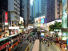
Yee Wo Street ( Chinese: 怡和街; Cantonese Yale: yi4 wo2 gaai1) is a street in East Point and Causeway Bay, Hong Kong Island, Hong Kong. Its junction with Hennessy Road is one of the busiest junctions in Hong Kong.
Name
Yeewo was the Cantonese name of a Qing dynasty hong established by Wǔ Guóyíng ( simplified Chinese: 五国莹; traditional Chinese: 伍國瑩) in Canton in 1783, which later became the leader of the cohong of the Thirteen Factories under the stewardship of Howqua, who took over in 1803. The name was later used by trading company Jardine, Matheson & Co., owners of much land in East Point in the early days of Hong Kong.
The road was renamed "Kasuga-dori" (春日通) during the Japanese occupation of Hong Kong. [1] After the surrender and evacuation of the Japanese army, the name was reverted.
Features
The street begins west at Hennessy Road and ends east in Causeway Road. It hosts a section of Hong Kong Tramways and its Causeway Bay terminus. During the 2014 Hong Kong protests (aka "Umbrella Revolution"), substantial tracts of the area were occupied by suffragists.
See also
References
-
^ Chan, Chan, Ka-leung (2011).
Witness of history: a case study of street signs at Pei Ho Street as an important urban heritage in Hong Kong (Master of Science in Conservation thesis).
University of Hong Kong. p. 31.
{{
cite thesis}}
: CS1 maint: multiple names: authors list ( link)
This article needs additional citations for
verification. (October 2014) |
 | |
| Native name | 怡和街 ( Yue Chinese) |
|---|---|
| Former name(s) | Kasuga-dori (1942–1945, during Japanese occupation) |
| Length | 300 metres (980 ft) |
| Width | 2 lanes of traffic eastbound, 1 lane westbound |
| Location | Causeway Bay, Hong Kong |
| Coordinates | 22°16′47″N 114°11′10″E / 22.2798°N 114.1860°E |
| Construction | |
| Inauguration | 1902 |
| Yee Wo Street | |||||||||||
|---|---|---|---|---|---|---|---|---|---|---|---|
| Chinese | 怡和街 | ||||||||||
| |||||||||||

Yee Wo Street ( Chinese: 怡和街; Cantonese Yale: yi4 wo2 gaai1) is a street in East Point and Causeway Bay, Hong Kong Island, Hong Kong. Its junction with Hennessy Road is one of the busiest junctions in Hong Kong.
Name
Yeewo was the Cantonese name of a Qing dynasty hong established by Wǔ Guóyíng ( simplified Chinese: 五国莹; traditional Chinese: 伍國瑩) in Canton in 1783, which later became the leader of the cohong of the Thirteen Factories under the stewardship of Howqua, who took over in 1803. The name was later used by trading company Jardine, Matheson & Co., owners of much land in East Point in the early days of Hong Kong.
The road was renamed "Kasuga-dori" (春日通) during the Japanese occupation of Hong Kong. [1] After the surrender and evacuation of the Japanese army, the name was reverted.
Features
The street begins west at Hennessy Road and ends east in Causeway Road. It hosts a section of Hong Kong Tramways and its Causeway Bay terminus. During the 2014 Hong Kong protests (aka "Umbrella Revolution"), substantial tracts of the area were occupied by suffragists.
See also
References
-
^ Chan, Chan, Ka-leung (2011).
Witness of history: a case study of street signs at Pei Ho Street as an important urban heritage in Hong Kong (Master of Science in Conservation thesis).
University of Hong Kong. p. 31.
{{
cite thesis}}
: CS1 maint: multiple names: authors list ( link)