Photos • Location
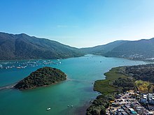
Wu Chau in
Three Fathoms Cove. The village on the right is
Tseng Tau. The
Yung Shue O marine
fish culture zone is visible on the left.

Wu Chau and its
tombolo.


_03.jpg)
Wu Chau ( Chinese: 烏洲) is an uninhabited island of Hong Kong, located in Three Fathoms Cove, in Tai Po District.
Wu Chau is connected to the mainland near Tseng Tau via a tombolo.
See also
Wikimedia Commons has media related to
Wu Chau (Tai Po).
Further reading
- Faure, David (1988). "The Man the Emperor Decapitated". Journal of the Royal Asiatic Society Hong Kong Branch. 28: 198–203. ISSN 1991-7295. JSTOR 23887154.
22°25′32″N 114°16′23″E / 22.425441°N 114.273032°E
|
| This New Territories location article is a stub. You can help Wikipedia by expanding it. |