Photos • Location

| Wrightington Bar | |
|---|---|
 Wrightington Bar | |
Location within
Lancashire | |
| OS grid reference | SD534134 |
| Civil parish | |
| District | |
| Shire county | |
| Region | |
| Country | England |
| Sovereign state | United Kingdom |
| Post town | WIGAN |
| Postcode district | WN6 |
| Dialling code | 01257 |
| Police | Lancashire |
| Fire | Lancashire |
| Ambulance | North West |
| UK Parliament | |
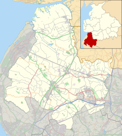
Wrightington Bar is a small linear village in West Lancashire, England. [1] It is on the B5250 Appley Bridge to Eccleston road, and is in the civil parish of Wrightington. [2]
See also
References
- ^ Ordnance Survey: Landranger map sheet 108 Liverpool (Southport & Wigan) (Map). Ordnance Survey. 2010. ISBN 9780319228388.
- ^ "Ordnance Survey Election Maps". www.ordnancesurvey.co.uk. Ordnance Survey. Retrieved 18 February 2016.
Wikimedia Commons has media related to
Wrightington Bar.
| Wrightington Bar | |
|---|---|
 Wrightington Bar | |
Location within
Lancashire | |
| OS grid reference | SD534134 |
| Civil parish | |
| District | |
| Shire county | |
| Region | |
| Country | England |
| Sovereign state | United Kingdom |
| Post town | WIGAN |
| Postcode district | WN6 |
| Dialling code | 01257 |
| Police | Lancashire |
| Fire | Lancashire |
| Ambulance | North West |
| UK Parliament | |
Wrightington Bar is a small linear village in West Lancashire, England. [1] It is on the B5250 Appley Bridge to Eccleston road, and is in the civil parish of Wrightington. [2]
See also
References
- ^ Ordnance Survey: Landranger map sheet 108 Liverpool (Southport & Wigan) (Map). Ordnance Survey. 2010. ISBN 9780319228388.
- ^ "Ordnance Survey Election Maps". www.ordnancesurvey.co.uk. Ordnance Survey. Retrieved 18 February 2016.
Wikimedia Commons has media related to
Wrightington Bar.

