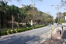
 Near the south end of Wong Nai Chung Gap Road opposite the St. John War Memorial | |
| Native name | 黃泥涌峽道 ( Yue Chinese) |
|---|---|
| Namesake | Wong Nai Chung Gap |
| Length | 1.2 km (0.75 mi) |
| Location | Hong Kong |
| Coordinates | 22°15′40″N 114°11′27″E / 22.261054°N 114.190731°E |
| Southeast end | Deep Water Bay Road and Repulse Bay Road near Wong Nai Chung Reservoir |
| Northwest end | Tai Hang Road and Stubbs Road |
| Construction | |
| Inauguration | 7th October 1932 |
| Wong Nai Chung Gap Road | |||||||||||
|---|---|---|---|---|---|---|---|---|---|---|---|
| Traditional Chinese | 黃泥涌峽道 | ||||||||||
| |||||||||||
Wong Nai Chung Gap Road ( Chinese: 黃泥涌峽道) is a road in Wan Chai District and Southern District, located within Wong Nai Chung Gap within Hong Kong.
The road was built at the strategic pass on Hong Kong Island, named Wong Nai Chung Gap. It was a key road leading from Victoria Harbour towards Stanley and Wong Chuk Hang through this Gap before continuing along Repulse Bay Road down towards the south. It was the site of a major engagement during the Battle of Hong Kong during World War II. [1] [2]
The usage of the road decreased following the opening of the Aberdeen Tunnel, but is now a popular starting point for hikers hiking on the Wong Nai Chung Trail, Wilson Trail or towards Tai Tam. [3]
- The French International School of Hong Kong
- Hong Kong Cricket Club
- St. John War Memorial
- Wong Nai Chung Reservoir
Roads are listed north to south.
- ^ "Wong Nai Chung Gap Trail - Hong Kong's Battlefield Trail | Drone & DSLR". Retrieved 23 August 2023.
- ^ "How to hike the historic Wong Nai Chung Gap Trail". Localiiz. Retrieved 23 August 2023.
- ^ "[歷史遊踪 x 週末行山] 黃泥涌峽看香港保衛戰 | Fitz 運動平台". fitz.hk. 22 December 2016. Retrieved 23 August 2023.