Winthrop, New York | |
|---|---|
| Coordinates: 44°47′44″N 74°47′9″W / 44.79556°N 74.78583°W | |
| Country | United States |
| State | New York |
| County | St. Lawrence |
| Town | Stockholm |
| Area | |
| • Total | 2.80 sq mi (7.25 km2) |
| • Land | 2.78 sq mi (7.19 km2) |
| • Water | 0.02 sq mi (0.06 km2) |
| Elevation | 338 ft (103 m) |
| Population (
2020) | |
| • Total | 489 |
| • Density | 176.09/sq mi (68.00/km2) |
| Time zone | UTC-5 ( Eastern (EST)) |
| • Summer ( DST) | UTC-4 (EDT) |
| ZIP Code | 13697 13613 ( Brasher Falls) |
| Area code(s) | 315/680 |
| FIPS code | 36-82612 |
| GNIS feature ID | 2584303 [2] |
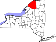
Winthrop is a hamlet and census-designated place (CDP) in the town of Stockholm in St. Lawrence County, New York, United States. As of the 2010 census, it had a population of 510.
The community is in northeastern St. Lawrence County, in the northeastern part of the town of Stockholm. It is bordered to the northeast by the community of Brasher Falls in the town of Brasher. The St. Regis River, a tributary of the St. Lawrence River, forms the southeastern border.
New York State Route 11C passes through Winthrop, leading southwest 3 miles (5 km) to U.S. Route 11 at Stockholm Center, and looping northeast, east, and south 8 miles (13 km) to rejoin Route 11 at Cotey Corners in the town of Lawrence. The village of Potsdam is 13 miles (21 km) southwest of Winthrop. State Route 420 crosses NY 11C in the center of Winthrop; it leads north-northwest 11 miles (18 km) to Massena and south 1.5 miles (2.4 km) to US-11.
Demographics
| Census | Pop. | Note | %± |
|---|---|---|---|
| 2020 | 489 | — | |
| U.S. Decennial Census [3] | |||
References
- ^ "ArcGIS REST Services Directory". United States Census Bureau. Retrieved September 20, 2022.
- ^ "Winthrop Census Designated Place". Geographic Names Information System. United States Geological Survey, United States Department of the Interior.
- ^ "Census of Population and Housing". Census.gov. Retrieved June 4, 2016.


