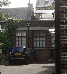
| Wilson Road Synagogue | |
|---|---|
 | |
| Religion | |
| Affiliation | Judaism |
| Rite | Independent Orthodox |
| Year consecrated | 1930 |
| Status | Converted to church |
| Location | |
| Location | Sheffield, England |
| Geographic coordinates | 53°22′11″N 1°29′56″W / 53.3696°N 1.4988°W |
| Architecture | |
| Architect(s) | Mansell Jenkinson |
| Type | Synagogue |
| Style | Neo-classical |
| Capacity | 970 |
The Wilson Road Synagogue was the largest synagogue in Sheffield in England for much of the twentieth-century.
History
Sheffield had a Jewish population from the 1780s, and its first synagogue was built in 1851 on Fig Tree Lane in the city centre. However, communal disputes led to a second congregation being established on North Church Street in 1914. This group constructed a synagogue on Wilson Road, near Hunters Bar, in 1930. [1]

The building was designed by Mansell Jenkinson in a classical style, featuring a portico in the Doric order. It is built of brick, with faience dressings, and also has notable internal features, including a granite ark, choir gallery and hardwood pews. [2] [3] The sukkah is in a neighbouring building, designed so that its flat roof can be slid open. [4]
During World War II, the city centre synagogue was destroyed by bombing, and much of its community came to worship at Wilson Road. However, they later established a new building, Kingfield Hall, in Nether Edge. The Jewish population of the city reached about 1,500 in the 1950s, but then entered a long decline. In the 1960s, the two communities joined together, and in 2000, the resulting independent congregation moved to a new building at the Kingfield Hall site. [5] The Wilson Road Synagogue was subsequently converted into a church. [2]
Both synagogue and sukkah were listed at grade II in 1992, along with the boundary wall and gates. [3] [4] [6]
See also
References
- ^ Armin Krausz, Sheffield Jewry, p.128
- ^ a b Ruth Harman et al, Pevsner Architectural Guide: Sheffield, p.262
- ^ a b Historic England. "Synagogue, Wilson Road (1270715)". National Heritage List for England. Retrieved 7 September 2015.
- ^ a b Historic England. "Succah 2 metres south west of synagogue (1254575)". National Heritage List for England. Retrieved 7 September 2015.
- ^ "History of our community". Sheffield Jewish Congregation and Centre. Retrieved 7 September 2015.
- ^ Historic England. "Boundary wall and gates to synagogue, Wilson Road (1067334)". National Heritage List for England. Retrieved 7 September 2015.
| Wilson Road Synagogue | |
|---|---|
 | |
| Religion | |
| Affiliation | Judaism |
| Rite | Independent Orthodox |
| Year consecrated | 1930 |
| Status | Converted to church |
| Location | |
| Location | Sheffield, England |
| Geographic coordinates | 53°22′11″N 1°29′56″W / 53.3696°N 1.4988°W |
| Architecture | |
| Architect(s) | Mansell Jenkinson |
| Type | Synagogue |
| Style | Neo-classical |
| Capacity | 970 |
The Wilson Road Synagogue was the largest synagogue in Sheffield in England for much of the twentieth-century.
History
Sheffield had a Jewish population from the 1780s, and its first synagogue was built in 1851 on Fig Tree Lane in the city centre. However, communal disputes led to a second congregation being established on North Church Street in 1914. This group constructed a synagogue on Wilson Road, near Hunters Bar, in 1930. [1]

The building was designed by Mansell Jenkinson in a classical style, featuring a portico in the Doric order. It is built of brick, with faience dressings, and also has notable internal features, including a granite ark, choir gallery and hardwood pews. [2] [3] The sukkah is in a neighbouring building, designed so that its flat roof can be slid open. [4]
During World War II, the city centre synagogue was destroyed by bombing, and much of its community came to worship at Wilson Road. However, they later established a new building, Kingfield Hall, in Nether Edge. The Jewish population of the city reached about 1,500 in the 1950s, but then entered a long decline. In the 1960s, the two communities joined together, and in 2000, the resulting independent congregation moved to a new building at the Kingfield Hall site. [5] The Wilson Road Synagogue was subsequently converted into a church. [2]
Both synagogue and sukkah were listed at grade II in 1992, along with the boundary wall and gates. [3] [4] [6]
See also
References
- ^ Armin Krausz, Sheffield Jewry, p.128
- ^ a b Ruth Harman et al, Pevsner Architectural Guide: Sheffield, p.262
- ^ a b Historic England. "Synagogue, Wilson Road (1270715)". National Heritage List for England. Retrieved 7 September 2015.
- ^ a b Historic England. "Succah 2 metres south west of synagogue (1254575)". National Heritage List for England. Retrieved 7 September 2015.
- ^ "History of our community". Sheffield Jewish Congregation and Centre. Retrieved 7 September 2015.
- ^ Historic England. "Boundary wall and gates to synagogue, Wilson Road (1067334)". National Heritage List for England. Retrieved 7 September 2015.
