| This page is an archive. Do not edit the contents of this page. Please direct any additional comments to the current main page. |

Accessbility issues with existing map
-
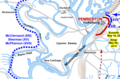 Crop of a larger map of the Vicksburg campaign
.png)
- Article(s)
- Duckport Canal
- Request
- The use of color to differentiate the Union and Confederate forces is not in compliance with MOS:COLOR, which has become a minor point at Wikipedia:Featured article candidates/Duckport Canal/archive1. The map can be trusted to be correct, as the original creator is a professional cartographer specializing in the Civil War and his work has been published in RS. If it makes it any easier, the yellow text with the events/dates in May and the dashed red line are not essential. -- Hog Farm Talk 23:29, 13 August 2022 (UTC)
- Discussion
@ Hog Farm: I'm not sure I understand what you mean by "not essential". Can you please be more specific (stating exactly what needs to changed or deleted)? M.Bitton ( talk) 00:24, 14 August 2022 (UTC)
- @
M.Bitton: basically if those items would make any work on the image harder, they can be omitted. But they're also okay to leave in. Whatever makes work on the image easier.
Hog Farm
Talk 02:03, 14 August 2022 (UTC)
- @ Hog Farm: from what I can tell, the current red is the only colour that is not blind safe. Let me know if you want me to replace it (with #b30000). M.Bitton ( talk) 23:53, 14 August 2022 (UTC)
- I went ahead with the change. Feel free to revert if that's not what you had in mind. M.Bitton ( talk) 00:04, 15 August 2022 (UTC)
 Done
M.Bitton (
talk) 22:33, 15 August 2022 (UTC)
Done
M.Bitton (
talk) 22:33, 15 August 2022 (UTC)
- Thank you! This can be marked as {{ resolved}}
Ukraine globe map
-
 Globe map
 -
 Europe map
 -

-

.svg)
.png)
.svg)
.svg)
- Article(s)
- Ukraine
- Request
- Please bring the globe map in line with the Europe map. Both are supposed to display the regions under occupation prior to the invasion, as currently used in the infobox of Ukraine, but the globe map shows only Crimea, not the Donbas. ― Tartan357 Talk 00:05, 4 July 2022 (UTC)
- Discussion
@ Tartan357: Someone made the same request (a few months ago). Please have a look a the maps (3 and 4) that I created for them back then. M.Bitton ( talk) 00:27, 4 July 2022 (UTC)
Code corrections needed for widely used UN map
-
 UN member states
 -
 New map

.svg)
- Article(s)
- multiple articles on multiple wikis
- Request
- An error was introduced into the map in August 2021, and the people on Commons can't figure it out. There is speculation that it may be because the SVG code is invalid.
- Antarctica is light grey in the SVG, as it's not a UN member state, a recognized territory of a state, or a UN observer. However, in all of the PNG previews, which is what nearly all readers see, Antarctica is colored blue.
- Further, I requested that blue non-states dots be removed, because showing them will mislead people into thinking that they're member states, and that was supported on the talk page: Chipmunkdavis advised "to set circle opacity to 0 for the various non-state dots". The map is edit-protected, so could that correction be done together with fixing Antarctica?
- I am notifying the map talk page of this request. -- — kwami ( talk) 01:27, 2 July 2022 (UTC)
- Discussion
- I must correct my speculation in the linked discussion about code validity, the SVG is now shown as valid on Commons and the W3C validator says the same (double-checked). I was also speculating about the order in which the embedded CSS rules are applied to the Antartica layer, but this also seems to be implemented correctly code-wise. I also purged the image a couple of times to no effect. -- Prüm ( talk) 05:25, 2 July 2022 (UTC)
-
 Request taken by
M.Bitton (
talk) 22:30, 3 July 2022 (UTC).
Request taken by
M.Bitton (
talk) 22:30, 3 July 2022 (UTC). - Done (I think). Rather than waste time chasing gremlins, I created a new map using an updated base (the sources for the list and the official colour are listed on Commons). Once everyone is happy with the change, we can ask an admin on Commons to overwrite the old one.
M.Bitton (
talk) 01:02, 4 July 2022 (UTC)
- @ M.Bitton and Prüm: Thanks!
- A few loose ends: (1) We're missing Singapore (blue) and Vatican City (Holy See? Prüm, what is the proper name to use? The old map says Vatican, but our list of observer states has Holy See.) (grey). Should probably also have a grey dot for Palestine, as in the old map, since it's so small. (2) Antarctica should be a lighter grey, per the old map, as it's neither an observer nor an occupied country. Not sure if the UN recognizes South Georgia and the South Sandwich Islands as British -- maybe those should be grey as well. (3) Prüm, should we have dots for Niue and Cooks, since they have standing invitations to join the UN? (4) The name of both Taiwan and the PRC should be changed to just "China", since the UN only recognizes one China, and both states claim to be it. That's a problem with the existing map too: it makes it seem that China and Taiwan are separate member states. — kwami ( talk) 01:20, 4 July 2022 (UTC)
- Okay, I went ahead and made those changes myself. Still "Vatican", S.Georgia still blue.
- Antarctica is buggy on this map too, though. I changed it to a lighter grey, but in the PNG previews it's still dark grey. So the gremlin in the original UN map was apparently inherited from the parent world map.
— kwami (
talk) 05:38, 4 July 2022 (UTC)
- I kept most of your changes and reinstated some of the names of the territories that were deleted (as the map is saved in a human-editable format, commenting them out, like you did for Crimea, is a better option for future changes). Antarctica looks fine (you'll notice that it has its own class). Please highlight any other issues.
M.Bitton (
talk) 13:56, 4 July 2022 (UTC)
- The color of blue looks off. It would probably be best to match UN blue for this --
Guerillero
Parlez Moi 20:46, 4 July 2022 (UTC)
- @ Guerillero: It's the official UN blue. M.Bitton ( talk) 20:48, 4 July 2022 (UTC)
- The UN flag file is edit-protected, so I left a request to match it to this blue. @
M.Bitton:, perhaps you'd like to do that? And yes, whatever you did to Ant fixed it in the PNG previews.
— kwami (
talk) 21:39, 4 July 2022 (UTC)
- @
Kwamikagami:. Sure thing. Is there anything else you want me to adjust or change before starting to apply the final touches to the map? Also, is there a particular reason why you changed the size of the circle around Jamaica? Those circles are meant to highlight the small islands, but in my view, Jamaica needs a bigger circle, otherwise it looks strange. 22:27, 4 July 2022 (UTC)
- @ M.Bitton: To me, it looks strange for Jamaica to have an oversized dot, unlike Cyprus or any other country. Fiji also looks odd with its dot in the middle of the ocean; the dot looks like it's a different country, but I didn't want to mess with it.
- As for other adjustments, just verifying we're consistent with what i brought up for the other map: IMO blue areas should have the name of the member state in their pop-up label (e.g. Puerto Rico should just be "USA", as Hawaii is); grey territories can be under their own name because the color makes it clear that they aren't separate member states. Currently we have dots for small member states, observer states (Vatican and Palestine), and invitee states (Cooks and Niue). Although this isn't a map on decolonization, I wouldn't be opposed to adding grey dots for the territories on the UN list of "Non-Self-Governing Territories" (the UK overseas territories, 3 US, 3 French, Tokelau and W. Sahara). Maybe a good idea if they're going to have pop-up labels. Though if we did that, then IMO they should be smaller dots than Cooks and Niue, which can join the UN any time they like and so aren't on the non-self-governing list. I think the only pop-up labels should be member/observer/invitee countries and the recognized non-self-governing states (maybe adjusted a bit to make the French territories consistent).
- Also, do we want the observer states to have a distinct color? I suppose we probably should, but don't know which color, so could use some 3rd-party input here. Input on that and on whether we should have small grey dots for the territories on the UN list.
— kwami (
talk) 09:58, 5 July 2022 (UTC)
- I adjusted Fiji's circle, assigned SGSSI to the UK, removed the highlights from Cooks and Niue (as they are neither members nor observers) and assigned the colour green to the two observer States (Holy See and the State of Palestine). This should address most, if not all, of the issues that have been raised here and on Commmons, while sticking to what is being depicted (the member States) and keeping the map properly sourced. M.Bitton ( talk) 17:00, 6 July 2022 (UTC)
- @
Kwamikagami:. Sure thing. Is there anything else you want me to adjust or change before starting to apply the final touches to the map? Also, is there a particular reason why you changed the size of the circle around Jamaica? Those circles are meant to highlight the small islands, but in my view, Jamaica needs a bigger circle, otherwise it looks strange. 22:27, 4 July 2022 (UTC)
- The color of blue looks off. It would probably be best to match UN blue for this --
Guerillero
Parlez Moi 20:46, 4 July 2022 (UTC)
- I kept most of your changes and reinstated some of the names of the territories that were deleted (as the map is saved in a human-editable format, commenting them out, like you did for Crimea, is a better option for future changes). Antarctica looks fine (you'll notice that it has its own class). Please highlight any other issues.
M.Bitton (
talk) 13:56, 4 July 2022 (UTC)
SVG labels are bad
-
 Major League Baseball blackout areas map

- Article(s)
- No articles
- Request
- Could you fix the labels at the top of the map? For some reason, the words are all messed up because the letters overlap; for example, "Florida" looks like "Fbḋa". A derived PNG image, File:MLB Blackout Areas.png, is used on six articles on four projects, and its description page says that it was created because of this page's bad rendering. 49.198.51.54 ( talk) 21:20, 29 June 2022 (UTC)
- Discussion
![]() Done
M.Bitton (
talk) 23:55, 8 July 2022 (UTC)
Done
M.Bitton (
talk) 23:55, 8 July 2022 (UTC)
Map of St. John's Metropolitan Area

.svg)
- Article(s)
- 2019 Challenge Trophy and St. John's metropolitan area
- Request
- I'm looking to have a map of the
St. John's metropolitan area added so that I can use it as part of a 'Venues' section in the
2019 Challenge Trophy article and the parent article. It would need to appear as part of the
{{
Location map~}}
template so return {
name = "St. John's, Newfoundland and Labrador", top = 47.83, bottom = 47.27, left = -53.24, right = -52.45, image = "St. John's metropolitan area (location map).svg", } (or similar naming convention) would need to be created for the file to live at.
- Above is an OSM location map with an example of what scale it should be, and what I'd be trying to accomplish with the
{{
Location map+}}
template when completed. Here is also an external PDF link from the NL gov't that identifies the census metropolitan area: https://www.stats.gov.nl.ca/Maps/pdfs/StJohnsCMA.pdf. — Zadora13 ( talk) 01:13, 23 August 2022 (UTC) - Discussion
-
Request taken by
M.Bitton (
talk) 18:45, 24 August 2022 (UTC).
- Done @
Zadora13: I hope that's what you had in mind. The geographic limits are listed on Commons.
M.Bitton (
talk) 21:41, 24 August 2022 (UTC)
- {{ Resolved}} Perfect, thanks M.Bitton. Much appreciated! Zadora13 ( talk) 22:49, 24 August 2022 (UTC)
USA map
{{ resolved}}

- Article(s)
- critical race theory
- Censorship of school curricula in the United States
- Request
- Hi just wondering can sombody make a map of the US on which states have laws banning, or proposed bill or failed bill on banning critical race theory. Here are sources.
[1] Thanks. La lopi ( talk) 14:09, 21 July 2022 (UTC)
- Discussion
![]() Request taken by
M.Bitton (
talk) 14:48, 21 July 2022 (UTC).
Request taken by
M.Bitton (
talk) 14:48, 21 July 2022 (UTC).
@ La lopi: can you please suggest an appropriate title for the map, a short description and categories to add to Commons? Thanks. M.Bitton ( talk) 16:32, 21 July 2022 (UTC)
@
La lopi: ![]() Done Feel free to adjust the Commons' description, legends and categories.
M.Bitton (
talk) 17:00, 21 July 2022 (UTC)
Done Feel free to adjust the Commons' description, legends and categories.
M.Bitton (
talk) 17:00, 21 July 2022 (UTC)
Thank you, Great map. La lopi ( talk) 04:29, 23 July 2022 (UTC)
The ABC colors are counter-intuitive for WP: here bans are usually red, not the reverse. I swapped the red and blue in the map. — kwami ( talk) 08:36, 23 July 2022 (UTC)
Quick SVG tweak
{{ resolved}}
-
 New York parking violations by country of diplomat

- Article(s)
- Parking violation
- Request
- French Guiana is coloured differently from metropolitan France; please give it the same colour. This map shows parking violations by each country's diplomats in New York City, so it's impossible for French Guiana and metropolitan France to have different data. 49.198.51.54 ( talk) 20:25, 2 August 2022 (UTC)
- Discussion
![]() Done
M.Bitton (
talk) 23:08, 2 August 2022 (UTC)
Done
M.Bitton (
talk) 23:08, 2 August 2022 (UTC)
New location maps

-
location map of Phoenix, Arizona
-
location map of Tucson, Arizona
-
location map showing Miami-Dade, Broward, and Palm Beach counties in Florida
- Article(s)
- KASW
- KUAT-TV / Arizona Public Media
- WFOR-TV
- WTVJ
- Request
- Requesting new location maps for use in a series of television and radio article projects. Inset maps of Phoenix and Tucson are needed to illustrate transmitter locations. The South Florida location map would be used to illustrate a discussion on a transmitter site. Sammi Brie (she/her • t • c) 18:03, 13 July 2022 (UTC)
- Discussion
- @ Sammi Brie: Will either of these existing location maps suit your needs? Module:Location map/data/Miami, Florida and Module:Location map/data/USA Arizona Maricopa County. If you haven't ready, consider {{ Maplink}} as alternative until a location map gets created in the areas listed in your request. - DutchTreat ( talk) 17:27, 18 July 2022 (UTC)
- @
DutchTreat The Maricopa County map will definitely work. The Miami map does not; one pin is going to be near Homestead and another near the Broward County line. I'm mostly planning ahead with these. The Tucson map is probably the one I'd like soonest.
Sammi Brie (she/her •
t •
c) 17:31, 18 July 2022 (UTC)
- @ Sammi Brie: Glad that Phoenix is already covered by an existing map. I'm behind on my backlog. Not ready today to pick up your request. Let's see if someone else is ready before I can get to this. - DutchTreat ( talk) 18:05, 18 July 2022 (UTC)
McGillivray properties
-
Description of first image
-
Description of second image (if needed)
-
Description of third image (if needed; don't request too many at once, though)
- Article(s)
- Sophia Durant
- Request
- There is a map in this 1855 book (p. 255) of the properties owned by en:Alexander McGillivray and his sisters, Sehoy (née McPherson) Weatherford, Sophia (née McGillivray) Durant, and Jeannete (née McGillivray) Milford. The locations are difficult to make out. The names are not in the forms in which these people are now known, i.e. M'Gillivray, sister of M'Gillivray (since he had 3, that isn't helpful), and since Creek property was held matrilineally, the properties never belonged to the husbands listed. I found this article (need access to project Muse, available from the Wikilibrary), which has updated the map (p 51) but obviously I cannot upload her correction as the article was published in February 2022, and thus copyrighted, but also, I think it is still unclear who the people are because, she has labeled for example #4 as Sehoy's place. Since the children's grandmother was known as Sehoy, their mother was Sehoy Marchand, and the person who owned the property in the map is Sehoy Weatherford, that label could easily confuse a reader. Also, it is unclear from the legend whether the map is referring to Alexander McGillivray's property, or his father en:Lachlan McGillivray's property. The explanation below the map in the original source makes this clear as it states "“The White Lieutenant, a half-breed Indian, is the great War Mico of the whole district…". As Lachlan was Scottish and after 1782 was living in Scotland, the property belongs to his son Alexander (by the Native woman Sehoy Marchand), who was a leader of the Creek Confederacy. I am hoping someone can clean up this map making it clearer where each of the siblings lived and who they were, i.e. 1, 2, 3 = Alexander McGillivray's whatever, 4=Sehoy (née McPherson) Weatherford's property, 5=Sophia (née McGillivray) Durant's property, 6=Jeannete (née McGillivray) Milford's property. I don't know if it is any help at all, but there is a digitized text of the 1855 book here. I cannot find the map on page 255, but there is a map noted as "Plate 29", which shows the n/s orientation and junctions of the Alabama, Coosa, and Tallapoosa Rivers, and marks Alexander McGillivray's location, though it is spelled McGillwray. Any help would be appreciated. -- SusunW ( talk) 22:09, 25 August 2022 (UTC)
- Discussion
- Hello @
SusunW, to make this clear, you want an estate map of the above? –
Berrely •
T∕
C 16:11, 27 August 2022 (UTC)
- Also it is possible you could email me the Muse article? You need to apply for it in TWL and I don't have access. –
Berrely •
T∕
C 16:15, 27 August 2022 (UTC)
-
Berrely Yes, if what you mean by "estate map" is that I want each of the residences/plantations of the various family members identified on a map which shows their locations. And, yes, I think I can download and e-mail the Muse article.
SusunW (
talk) 16:17, 27 August 2022 (UTC)
- Berrely, I was able to download, but you will need to respond to my e-mail so that I can send you the PDF file. SusunW ( talk) 16:23, 27 August 2022 (UTC)
-
Berrely Yes, if what you mean by "estate map" is that I want each of the residences/plantations of the various family members identified on a map which shows their locations. And, yes, I think I can download and e-mail the Muse article.
SusunW (
talk) 16:17, 27 August 2022 (UTC)
- Also it is possible you could email me the Muse article? You need to apply for it in TWL and I don't have access. –
Berrely •
T∕
C 16:15, 27 August 2022 (UTC)
{{ resolved}} SusunW ( talk) 19:35, 29 August 2022 (UTC)
Prospective Commonwealth members map - Gabon and Togo
{{ resolved}}
.png)
- Article(s)
- Any article this map already appears on.
- Request
- Gabon and Togo joined the Commonwealth of Nations earlier this year on 29 June, so they should be shaded blue on the above map to reflect that. Thanks. Snow Lion Fenian ( talk) 16:07, 30 August 2022 (UTC)
- Discussion
![]() Done
Dank
Jae 16:48, 30 August 2022 (UTC)
Done
Dank
Jae 16:48, 30 August 2022 (UTC)
- @ DankJae: That's fine, and thanks for helping. Snow Lion Fenian ( talk) 17:55, 30 August 2022 (UTC)
New York City civil court districts

- Article(s)
- New York City Civil Court
- Request
- Boundaries of Municipal Court districts map ( dataset?) on NYC OpenData from DoITT
- Some New York City Civil Court judges are elected in rather small districts within New York City, and I think a map would help the reader visualize that. The data is public domain unless otherwise noted per New York City Administrative Code title 23 chapter 5. Thank you in advance! 🙏 int21h ( talk · contribs · email) 03:37, 8 September 2022 (UTC)
- Discussion
![]() Request taken by —
twotwofourtysix(
talk ||
edits) 10:59, 8 September 2022 (UTC).
Request taken by —
twotwofourtysix(
talk ||
edits) 10:59, 8 September 2022 (UTC).
- Done —
twotwofourtysix(
talk ||
edits) 11:23, 8 September 2022 (UTC)
- {{ resolved}}
| This page is an archive. Do not edit the contents of this page. Please direct any additional comments to the current main page. |
Accessbility issues with existing map
-
Crop of a larger map of the Vicksburg campaign
- Article(s)
- Duckport Canal
- Request
- The use of color to differentiate the Union and Confederate forces is not in compliance with MOS:COLOR, which has become a minor point at Wikipedia:Featured article candidates/Duckport Canal/archive1. The map can be trusted to be correct, as the original creator is a professional cartographer specializing in the Civil War and his work has been published in RS. If it makes it any easier, the yellow text with the events/dates in May and the dashed red line are not essential. -- Hog Farm Talk 23:29, 13 August 2022 (UTC)
- Discussion
@ Hog Farm: I'm not sure I understand what you mean by "not essential". Can you please be more specific (stating exactly what needs to changed or deleted)? M.Bitton ( talk) 00:24, 14 August 2022 (UTC)
- @
M.Bitton: basically if those items would make any work on the image harder, they can be omitted. But they're also okay to leave in. Whatever makes work on the image easier.
Hog Farm
Talk 02:03, 14 August 2022 (UTC)
- @ Hog Farm: from what I can tell, the current red is the only colour that is not blind safe. Let me know if you want me to replace it (with #b30000). M.Bitton ( talk) 23:53, 14 August 2022 (UTC)
- I went ahead with the change. Feel free to revert if that's not what you had in mind. M.Bitton ( talk) 00:04, 15 August 2022 (UTC)
- Done
M.Bitton (
talk) 22:33, 15 August 2022 (UTC)
- Thank you! This can be marked as {{ resolved}}
Ukraine globe map
-
Globe map
-
Europe map
-
-
- Article(s)
- Ukraine
- Request
- Please bring the globe map in line with the Europe map. Both are supposed to display the regions under occupation prior to the invasion, as currently used in the infobox of Ukraine, but the globe map shows only Crimea, not the Donbas. ― Tartan357 Talk 00:05, 4 July 2022 (UTC)
- Discussion
@ Tartan357: Someone made the same request (a few months ago). Please have a look a the maps (3 and 4) that I created for them back then. M.Bitton ( talk) 00:27, 4 July 2022 (UTC)
Code corrections needed for widely used UN map
-
UN member states
-
New map
- Article(s)
- multiple articles on multiple wikis
- Request
- An error was introduced into the map in August 2021, and the people on Commons can't figure it out. There is speculation that it may be because the SVG code is invalid.
- Antarctica is light grey in the SVG, as it's not a UN member state, a recognized territory of a state, or a UN observer. However, in all of the PNG previews, which is what nearly all readers see, Antarctica is colored blue.
- Further, I requested that blue non-states dots be removed, because showing them will mislead people into thinking that they're member states, and that was supported on the talk page: Chipmunkdavis advised "to set circle opacity to 0 for the various non-state dots". The map is edit-protected, so could that correction be done together with fixing Antarctica?
- I am notifying the map talk page of this request. -- — kwami ( talk) 01:27, 2 July 2022 (UTC)
- Discussion
- I must correct my speculation in the linked discussion about code validity, the SVG is now shown as valid on Commons and the W3C validator says the same (double-checked). I was also speculating about the order in which the embedded CSS rules are applied to the Antartica layer, but this also seems to be implemented correctly code-wise. I also purged the image a couple of times to no effect. -- Prüm ( talk) 05:25, 2 July 2022 (UTC)
-
Request taken by
M.Bitton (
talk) 22:30, 3 July 2022 (UTC).
- Done (I think). Rather than waste time chasing gremlins, I created a new map using an updated base (the sources for the list and the official colour are listed on Commons). Once everyone is happy with the change, we can ask an admin on Commons to overwrite the old one.
M.Bitton (
talk) 01:02, 4 July 2022 (UTC)
- @ M.Bitton and Prüm: Thanks!
- A few loose ends: (1) We're missing Singapore (blue) and Vatican City (Holy See? Prüm, what is the proper name to use? The old map says Vatican, but our list of observer states has Holy See.) (grey). Should probably also have a grey dot for Palestine, as in the old map, since it's so small. (2) Antarctica should be a lighter grey, per the old map, as it's neither an observer nor an occupied country. Not sure if the UN recognizes South Georgia and the South Sandwich Islands as British -- maybe those should be grey as well. (3) Prüm, should we have dots for Niue and Cooks, since they have standing invitations to join the UN? (4) The name of both Taiwan and the PRC should be changed to just "China", since the UN only recognizes one China, and both states claim to be it. That's a problem with the existing map too: it makes it seem that China and Taiwan are separate member states. — kwami ( talk) 01:20, 4 July 2022 (UTC)
- Okay, I went ahead and made those changes myself. Still "Vatican", S.Georgia still blue.
- Antarctica is buggy on this map too, though. I changed it to a lighter grey, but in the PNG previews it's still dark grey. So the gremlin in the original UN map was apparently inherited from the parent world map.
— kwami (
talk) 05:38, 4 July 2022 (UTC)
- I kept most of your changes and reinstated some of the names of the territories that were deleted (as the map is saved in a human-editable format, commenting them out, like you did for Crimea, is a better option for future changes). Antarctica looks fine (you'll notice that it has its own class). Please highlight any other issues.
M.Bitton (
talk) 13:56, 4 July 2022 (UTC)
- The color of blue looks off. It would probably be best to match UN blue for this --
Guerillero
Parlez Moi 20:46, 4 July 2022 (UTC)
- @ Guerillero: It's the official UN blue. M.Bitton ( talk) 20:48, 4 July 2022 (UTC)
- The UN flag file is edit-protected, so I left a request to match it to this blue. @
M.Bitton:, perhaps you'd like to do that? And yes, whatever you did to Ant fixed it in the PNG previews.
— kwami (
talk) 21:39, 4 July 2022 (UTC)
- @
Kwamikagami:. Sure thing. Is there anything else you want me to adjust or change before starting to apply the final touches to the map? Also, is there a particular reason why you changed the size of the circle around Jamaica? Those circles are meant to highlight the small islands, but in my view, Jamaica needs a bigger circle, otherwise it looks strange. 22:27, 4 July 2022 (UTC)
- @ M.Bitton: To me, it looks strange for Jamaica to have an oversized dot, unlike Cyprus or any other country. Fiji also looks odd with its dot in the middle of the ocean; the dot looks like it's a different country, but I didn't want to mess with it.
- As for other adjustments, just verifying we're consistent with what i brought up for the other map: IMO blue areas should have the name of the member state in their pop-up label (e.g. Puerto Rico should just be "USA", as Hawaii is); grey territories can be under their own name because the color makes it clear that they aren't separate member states. Currently we have dots for small member states, observer states (Vatican and Palestine), and invitee states (Cooks and Niue). Although this isn't a map on decolonization, I wouldn't be opposed to adding grey dots for the territories on the UN list of "Non-Self-Governing Territories" (the UK overseas territories, 3 US, 3 French, Tokelau and W. Sahara). Maybe a good idea if they're going to have pop-up labels. Though if we did that, then IMO they should be smaller dots than Cooks and Niue, which can join the UN any time they like and so aren't on the non-self-governing list. I think the only pop-up labels should be member/observer/invitee countries and the recognized non-self-governing states (maybe adjusted a bit to make the French territories consistent).
- Also, do we want the observer states to have a distinct color? I suppose we probably should, but don't know which color, so could use some 3rd-party input here. Input on that and on whether we should have small grey dots for the territories on the UN list.
— kwami (
talk) 09:58, 5 July 2022 (UTC)
- I adjusted Fiji's circle, assigned SGSSI to the UK, removed the highlights from Cooks and Niue (as they are neither members nor observers) and assigned the colour green to the two observer States (Holy See and the State of Palestine). This should address most, if not all, of the issues that have been raised here and on Commmons, while sticking to what is being depicted (the member States) and keeping the map properly sourced. M.Bitton ( talk) 17:00, 6 July 2022 (UTC)
- @
Kwamikagami:. Sure thing. Is there anything else you want me to adjust or change before starting to apply the final touches to the map? Also, is there a particular reason why you changed the size of the circle around Jamaica? Those circles are meant to highlight the small islands, but in my view, Jamaica needs a bigger circle, otherwise it looks strange. 22:27, 4 July 2022 (UTC)
- The color of blue looks off. It would probably be best to match UN blue for this --
Guerillero
Parlez Moi 20:46, 4 July 2022 (UTC)
- I kept most of your changes and reinstated some of the names of the territories that were deleted (as the map is saved in a human-editable format, commenting them out, like you did for Crimea, is a better option for future changes). Antarctica looks fine (you'll notice that it has its own class). Please highlight any other issues.
M.Bitton (
talk) 13:56, 4 July 2022 (UTC)
SVG labels are bad
-
Major League Baseball blackout areas map
- Article(s)
- No articles
- Request
- Could you fix the labels at the top of the map? For some reason, the words are all messed up because the letters overlap; for example, "Florida" looks like "Fbḋa". A derived PNG image, File:MLB Blackout Areas.png, is used on six articles on four projects, and its description page says that it was created because of this page's bad rendering. 49.198.51.54 ( talk) 21:20, 29 June 2022 (UTC)
- Discussion
![]() Done
M.Bitton (
talk) 23:55, 8 July 2022 (UTC)
Done
M.Bitton (
talk) 23:55, 8 July 2022 (UTC)
Map of St. John's Metropolitan Area
- Article(s)
- 2019 Challenge Trophy and St. John's metropolitan area
- Request
- I'm looking to have a map of the
St. John's metropolitan area added so that I can use it as part of a 'Venues' section in the
2019 Challenge Trophy article and the parent article. It would need to appear as part of the
{{
Location map~}}
template so return {
name = "St. John's, Newfoundland and Labrador", top = 47.83, bottom = 47.27, left = -53.24, right = -52.45, image = "St. John's metropolitan area (location map).svg", } (or similar naming convention) would need to be created for the file to live at.
- Above is an OSM location map with an example of what scale it should be, and what I'd be trying to accomplish with the
{{
Location map+}}
template when completed. Here is also an external PDF link from the NL gov't that identifies the census metropolitan area: https://www.stats.gov.nl.ca/Maps/pdfs/StJohnsCMA.pdf. — Zadora13 ( talk) 01:13, 23 August 2022 (UTC) - Discussion
-
Request taken by
M.Bitton (
talk) 18:45, 24 August 2022 (UTC).
- Done @
Zadora13: I hope that's what you had in mind. The geographic limits are listed on Commons.
M.Bitton (
talk) 21:41, 24 August 2022 (UTC)
- {{ Resolved}} Perfect, thanks M.Bitton. Much appreciated! Zadora13 ( talk) 22:49, 24 August 2022 (UTC)
USA map
{{ resolved}}
- Article(s)
- critical race theory
- Censorship of school curricula in the United States
- Request
- Hi just wondering can sombody make a map of the US on which states have laws banning, or proposed bill or failed bill on banning critical race theory. Here are sources.
[1] Thanks. La lopi ( talk) 14:09, 21 July 2022 (UTC)
- Discussion
![]() Request taken by
M.Bitton (
talk) 14:48, 21 July 2022 (UTC).
Request taken by
M.Bitton (
talk) 14:48, 21 July 2022 (UTC).
@ La lopi: can you please suggest an appropriate title for the map, a short description and categories to add to Commons? Thanks. M.Bitton ( talk) 16:32, 21 July 2022 (UTC)
@
La lopi: ![]() Done Feel free to adjust the Commons' description, legends and categories.
M.Bitton (
talk) 17:00, 21 July 2022 (UTC)
Done Feel free to adjust the Commons' description, legends and categories.
M.Bitton (
talk) 17:00, 21 July 2022 (UTC)
Thank you, Great map. La lopi ( talk) 04:29, 23 July 2022 (UTC)
The ABC colors are counter-intuitive for WP: here bans are usually red, not the reverse. I swapped the red and blue in the map. — kwami ( talk) 08:36, 23 July 2022 (UTC)
Quick SVG tweak
{{ resolved}}
-
New York parking violations by country of diplomat
- Article(s)
- Parking violation
- Request
- French Guiana is coloured differently from metropolitan France; please give it the same colour. This map shows parking violations by each country's diplomats in New York City, so it's impossible for French Guiana and metropolitan France to have different data. 49.198.51.54 ( talk) 20:25, 2 August 2022 (UTC)
- Discussion
![]() Done
M.Bitton (
talk) 23:08, 2 August 2022 (UTC)
Done
M.Bitton (
talk) 23:08, 2 August 2022 (UTC)
New location maps
-
location map of Phoenix, Arizona
-
location map of Tucson, Arizona
-
location map showing Miami-Dade, Broward, and Palm Beach counties in Florida
- Article(s)
- KASW
- KUAT-TV / Arizona Public Media
- WFOR-TV
- WTVJ
- Request
- Requesting new location maps for use in a series of television and radio article projects. Inset maps of Phoenix and Tucson are needed to illustrate transmitter locations. The South Florida location map would be used to illustrate a discussion on a transmitter site. Sammi Brie (she/her • t • c) 18:03, 13 July 2022 (UTC)
- Discussion
- @ Sammi Brie: Will either of these existing location maps suit your needs? Module:Location map/data/Miami, Florida and Module:Location map/data/USA Arizona Maricopa County. If you haven't ready, consider {{ Maplink}} as alternative until a location map gets created in the areas listed in your request. - DutchTreat ( talk) 17:27, 18 July 2022 (UTC)
- @
DutchTreat The Maricopa County map will definitely work. The Miami map does not; one pin is going to be near Homestead and another near the Broward County line. I'm mostly planning ahead with these. The Tucson map is probably the one I'd like soonest.
Sammi Brie (she/her •
t •
c) 17:31, 18 July 2022 (UTC)
- @ Sammi Brie: Glad that Phoenix is already covered by an existing map. I'm behind on my backlog. Not ready today to pick up your request. Let's see if someone else is ready before I can get to this. - DutchTreat ( talk) 18:05, 18 July 2022 (UTC)
McGillivray properties
-
Description of first image
-
Description of second image (if needed)
-
Description of third image (if needed; don't request too many at once, though)
- Article(s)
- Sophia Durant
- Request
- There is a map in this 1855 book (p. 255) of the properties owned by en:Alexander McGillivray and his sisters, Sehoy (née McPherson) Weatherford, Sophia (née McGillivray) Durant, and Jeannete (née McGillivray) Milford. The locations are difficult to make out. The names are not in the forms in which these people are now known, i.e. M'Gillivray, sister of M'Gillivray (since he had 3, that isn't helpful), and since Creek property was held matrilineally, the properties never belonged to the husbands listed. I found this article (need access to project Muse, available from the Wikilibrary), which has updated the map (p 51) but obviously I cannot upload her correction as the article was published in February 2022, and thus copyrighted, but also, I think it is still unclear who the people are because, she has labeled for example #4 as Sehoy's place. Since the children's grandmother was known as Sehoy, their mother was Sehoy Marchand, and the person who owned the property in the map is Sehoy Weatherford, that label could easily confuse a reader. Also, it is unclear from the legend whether the map is referring to Alexander McGillivray's property, or his father en:Lachlan McGillivray's property. The explanation below the map in the original source makes this clear as it states "“The White Lieutenant, a half-breed Indian, is the great War Mico of the whole district…". As Lachlan was Scottish and after 1782 was living in Scotland, the property belongs to his son Alexander (by the Native woman Sehoy Marchand), who was a leader of the Creek Confederacy. I am hoping someone can clean up this map making it clearer where each of the siblings lived and who they were, i.e. 1, 2, 3 = Alexander McGillivray's whatever, 4=Sehoy (née McPherson) Weatherford's property, 5=Sophia (née McGillivray) Durant's property, 6=Jeannete (née McGillivray) Milford's property. I don't know if it is any help at all, but there is a digitized text of the 1855 book here. I cannot find the map on page 255, but there is a map noted as "Plate 29", which shows the n/s orientation and junctions of the Alabama, Coosa, and Tallapoosa Rivers, and marks Alexander McGillivray's location, though it is spelled McGillwray. Any help would be appreciated. -- SusunW ( talk) 22:09, 25 August 2022 (UTC)
- Discussion
- Hello @
SusunW, to make this clear, you want an estate map of the above? –
Berrely •
T∕
C 16:11, 27 August 2022 (UTC)
- Also it is possible you could email me the Muse article? You need to apply for it in TWL and I don't have access. –
Berrely •
T∕
C 16:15, 27 August 2022 (UTC)
-
Berrely Yes, if what you mean by "estate map" is that I want each of the residences/plantations of the various family members identified on a map which shows their locations. And, yes, I think I can download and e-mail the Muse article.
SusunW (
talk) 16:17, 27 August 2022 (UTC)
- Berrely, I was able to download, but you will need to respond to my e-mail so that I can send you the PDF file. SusunW ( talk) 16:23, 27 August 2022 (UTC)
-
Berrely Yes, if what you mean by "estate map" is that I want each of the residences/plantations of the various family members identified on a map which shows their locations. And, yes, I think I can download and e-mail the Muse article.
SusunW (
talk) 16:17, 27 August 2022 (UTC)
- Also it is possible you could email me the Muse article? You need to apply for it in TWL and I don't have access. –
Berrely •
T∕
C 16:15, 27 August 2022 (UTC)
{{ resolved}} SusunW ( talk) 19:35, 29 August 2022 (UTC)
Prospective Commonwealth members map - Gabon and Togo
{{ resolved}}
- Article(s)
- Any article this map already appears on.
- Request
- Gabon and Togo joined the Commonwealth of Nations earlier this year on 29 June, so they should be shaded blue on the above map to reflect that. Thanks. Snow Lion Fenian ( talk) 16:07, 30 August 2022 (UTC)
- Discussion
![]() Done
Dank
Jae 16:48, 30 August 2022 (UTC)
Done
Dank
Jae 16:48, 30 August 2022 (UTC)
- @ DankJae: That's fine, and thanks for helping. Snow Lion Fenian ( talk) 17:55, 30 August 2022 (UTC)
New York City civil court districts
- Article(s)
- New York City Civil Court
- Request
- Boundaries of Municipal Court districts map ( dataset?) on NYC OpenData from DoITT
- Some New York City Civil Court judges are elected in rather small districts within New York City, and I think a map would help the reader visualize that. The data is public domain unless otherwise noted per New York City Administrative Code title 23 chapter 5. Thank you in advance! 🙏 int21h ( talk · contribs · email) 03:37, 8 September 2022 (UTC)
- Discussion
![]() Request taken by —
twotwofourtysix(
talk ||
edits) 10:59, 8 September 2022 (UTC).
Request taken by —
twotwofourtysix(
talk ||
edits) 10:59, 8 September 2022 (UTC).
- Done —
twotwofourtysix(
talk ||
edits) 11:23, 8 September 2022 (UTC)
- {{ resolved}}