Stale Information
-
Put in this gallery any maps that may be helpful
-
ie: the map that needs correcting/editing/etc (obvious!)
-
or a base map that could be used in making the requested map
Article(s): India–Pakistan relations
Request: Creating two maps- 1. A blank map of the Indian state of Gujarat with only the Junagarh district shaded 2. A map of Kashmir reflecting the area of the entire state and the current controlling powers over it (possibly like the map in the lead at Insurgency in Jammu and Kashmir)
TheOriginalSoni ( talk) 20:24, 5 November 2012 (UTC)
Graphist opinion:
Article: Apostolic Vicariate of Northern Arabia (Bahrain, Kuwait, Qatar, and Saudi Arabia) and Roman Catholic Vicariate Apostolic of Southern Arabia (Oman, United Arab Emirates, and Yemen)
Request: A map of these Apostolic Vicariate]]s-- Dr Lol ( talk) 11:37, 19 September 2012 (UTC)
-
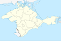
 Want this part cropped from the Maharashtra Location map.
 -
 extracted from this map
.svg)

Article(s): Buldhana district
Request: I would like to have that part extracted so that I can use it for further work on the district map. I would love to know if I can get tutorials somewhere about creating SVG locator maps. Shivashree ( talk) 10:15, 24 September 2012 (UTC)
Graphist opinion(s):
-
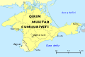 My map
 -
 Source map


Article(s): e.g. crh:Qırım Muhtar Cumhuriyeti
Request: Hi! I made this map with Inkscape for the Crimean Tatar Wikipedia, basing it on the existing outline map of Crimea. At least on my browsers (Safari and Firefox for Mac), the names for some of the cities are squished, especially Kezlev. If it's not just my browser, is there anything I should do to fix that? If people have other general suggestions about the map, I'd appreciate it, since it's my first one. Thanks! Lesgles ( talk) 22:51, 9 October 2012 (UTC)
-
 This could be the base map
 -
 Something like this


Article(s):
- Territories of Roman Catholic dioceses in India
- Catholic Church in India
- List of Roman Catholic dioceses in India
- List of cathedrals in India
- List of Catholic bishops of India
Request: Hello WikiCartographers, please can we have a map of the provinces and dioceses of the Catholic Church in India? I'm looking for something along the lines of the US map in the gallery above? There are 23 Latin rite provinces in India, which are further divided into dioceses. Each diocese is made up of a few civil districts which make up the map of India with districts. The list of districts that make up each diocese is available on the following sites/pages:
- Official website of the Catholic Bishops Conference of India
- UCAN India Diocesan Directory
- Territories of Roman Catholic dioceses in India
The UCAN site has the latest and most reliable data and the description pages of most of the dioceses have a map of India showing the outline of the diocese, which will be helpful. Thanks, The Discoverer ( talk) 15:59, 14 November 2012 (UTC)
References:
- CBCI website
- Territories of Roman Catholic dioceses in India
- List of districts of India
- Giga Catholic
- Catholic-Hierarchy
Graphist opinion:

Article(s): Cities, Metropolis
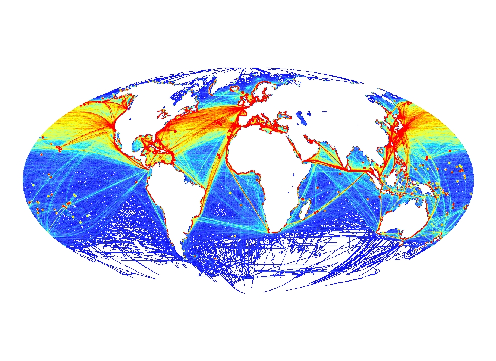
Request: A global urbanization map has allready been made (see Global_urbanization.png), yet it would be useful to also map the major cities in the world. Take over the cities from http://esa.un.org/unup/Maps/maps_urban_2011.htm and put them on a blank map. Perhaps also mark the travel time and major travel routes between the cities using this map: http://bioval.jrc.ec.europa.eu/products/gam/index.htm KVDP ( talk) 07:11, 16 October 2012 (UTC)
Graphist opinion(s):
Article(s): Sea
Request: A world seas map showing all 66 seas can be made, see http://ephotopix.com/image/world/world_ocean_sea_map.gif and http://media-2.web.britannica.com/eb-media/63/3163-004-AB1FF40C.jpg KVDP ( talk) 07:14, 16 October 2012 (UTC)
Graphist opinion(s):
wikiepedia's Somalia map (request to add Armo town)
Firstly I want to thank you for your valueble work in general and specially on Somalia, I am hereby requesting you to include your Somalia maps an important town named Carmo (Armo in english), which is 100KM south of Bosaso city of Puntland, Somalia,on the road between Bosaso and Gardo, the town was nearly founded in 1995, but has been rapidly gorwing and became an official distirct capital in 2003. by now it is well-designed large town,also it is home to UNDP sponsored Armo Somali Police Accademy, which is the largest in Somalia. the town had been on your maps of Somalia since 2009 and 2010, but after that you did not include it on your maps, could please include it again. I can understand that your maps show as much as possible of the towns and the villages of Somalia, but I think that Armo/Carmo town deserves to be shown on yours maps according to its relatively large size and importance. Sincve it is district capital, please show it with larger letters and spot. Note: You can get the location of Carmo on the this link
//upload.wikimedia.org/wikipedia/commons/archive/9/9f/20100313003018%21Somalia_map_states_regions_districts.png
Thanks,
Ahmed Yusuf Somali Journalist — Preceding unsigned comment added by 77.169.203.151 ( talk) 23:33, 17 October 2012 (UTC)
Article(s): Oil pollution, Environmental impact of shipping,
Request: Make a map based mostly on http://qed.princeton.edu/getfile.php?f=Pollution_of_the_Oceans.jpg (other references: http://tommytoy.typepad.com/.a/6a0133f3a4072c970b014e86bae56c970d-800wi and http://earthhabitat.files.wordpress.com/2010/02/oceanpollution.jpg ) KVDP ( talk) 10:16, 18 October 2012 (UTC)
Graphist opinion(s):
-
 The map in question
 -
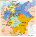 HRE post-Napoleonic Wars that has both a PNG and SVG version


Article(s): Holy Roman Empire
Request: This file concerning the HRE in 1789 was uploaded in PNG, though from the looks of it, was made in a vector graphics editor, like Inkscape. I believe that having the map in SVG format could make the map of better quality. Though, if the map cannot be traced into an SVG file, perhaps could the original SVG file be found and uploaded? 64.229.183.165 ( talk) 18:37, 18 November 2012 (UTC)
Graphist opinion:
-
 Map of the 2nd conflict
 -
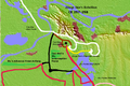 Map of the 3rd conflict
 -
 Map of the 1st conflict

Article(s): Guanqiu Jian and Wen Qin's Rebellion, Zhuge Dan's Rebellion, Wang Ling's Rebellion
Request: Can someone improve and master them? Make them good. And appealing to the eye. -- Eric - Contact me please. I prefer conversations started on my talk page if the subject is changed 21:36, 23 November 2012 (UTC)
Graphist opinion(s):
Resolved Information

Article(s): Visa requirements for United States citizens
Request: Map shows Hawaii in an incorrect color. Hawaii is part of the U.S. and should be shown in red. 71.109.153.135 ( talk) 19:29, 24 November 2012 (UTC)
Graphist opinion(s):
![]() Done: color of Hawaii is now correct, also some minor fixes have been performed. --
Niklem (
talk) 08:02, 5 December 2012 (UTC)
Done: color of Hawaii is now correct, also some minor fixes have been performed. --
Niklem (
talk) 08:02, 5 December 2012 (UTC)
Stale Information
-
Put in this gallery any maps that may be helpful
-
ie: the map that needs correcting/editing/etc (obvious!)
-
or a base map that could be used in making the requested map
Article(s): India–Pakistan relations
Request: Creating two maps- 1. A blank map of the Indian state of Gujarat with only the Junagarh district shaded 2. A map of Kashmir reflecting the area of the entire state and the current controlling powers over it (possibly like the map in the lead at Insurgency in Jammu and Kashmir)
TheOriginalSoni ( talk) 20:24, 5 November 2012 (UTC)
Graphist opinion:
Article: Apostolic Vicariate of Northern Arabia (Bahrain, Kuwait, Qatar, and Saudi Arabia) and Roman Catholic Vicariate Apostolic of Southern Arabia (Oman, United Arab Emirates, and Yemen)
Request: A map of these Apostolic Vicariate]]s-- Dr Lol ( talk) 11:37, 19 September 2012 (UTC)
-
Want this part cropped from the Maharashtra Location map.
-
extracted from this map
Article(s): Buldhana district
Request: I would like to have that part extracted so that I can use it for further work on the district map. I would love to know if I can get tutorials somewhere about creating SVG locator maps. Shivashree ( talk) 10:15, 24 September 2012 (UTC)
Graphist opinion(s):
-
My map
-
Source map
Article(s): e.g. crh:Qırım Muhtar Cumhuriyeti
Request: Hi! I made this map with Inkscape for the Crimean Tatar Wikipedia, basing it on the existing outline map of Crimea. At least on my browsers (Safari and Firefox for Mac), the names for some of the cities are squished, especially Kezlev. If it's not just my browser, is there anything I should do to fix that? If people have other general suggestions about the map, I'd appreciate it, since it's my first one. Thanks! Lesgles ( talk) 22:51, 9 October 2012 (UTC)
-
This could be the base map
-
Something like this
Article(s):
- Territories of Roman Catholic dioceses in India
- Catholic Church in India
- List of Roman Catholic dioceses in India
- List of cathedrals in India
- List of Catholic bishops of India
Request: Hello WikiCartographers, please can we have a map of the provinces and dioceses of the Catholic Church in India? I'm looking for something along the lines of the US map in the gallery above? There are 23 Latin rite provinces in India, which are further divided into dioceses. Each diocese is made up of a few civil districts which make up the map of India with districts. The list of districts that make up each diocese is available on the following sites/pages:
- Official website of the Catholic Bishops Conference of India
- UCAN India Diocesan Directory
- Territories of Roman Catholic dioceses in India
The UCAN site has the latest and most reliable data and the description pages of most of the dioceses have a map of India showing the outline of the diocese, which will be helpful. Thanks, The Discoverer ( talk) 15:59, 14 November 2012 (UTC)
References:
- CBCI website
- Territories of Roman Catholic dioceses in India
- List of districts of India
- Giga Catholic
- Catholic-Hierarchy
Graphist opinion:
Article(s): Cities, Metropolis
Request: A global urbanization map has allready been made (see Global_urbanization.png), yet it would be useful to also map the major cities in the world. Take over the cities from http://esa.un.org/unup/Maps/maps_urban_2011.htm and put them on a blank map. Perhaps also mark the travel time and major travel routes between the cities using this map: http://bioval.jrc.ec.europa.eu/products/gam/index.htm KVDP ( talk) 07:11, 16 October 2012 (UTC)
Graphist opinion(s):
Article(s): Sea
Request: A world seas map showing all 66 seas can be made, see http://ephotopix.com/image/world/world_ocean_sea_map.gif and http://media-2.web.britannica.com/eb-media/63/3163-004-AB1FF40C.jpg KVDP ( talk) 07:14, 16 October 2012 (UTC)
Graphist opinion(s):
wikiepedia's Somalia map (request to add Armo town)
Firstly I want to thank you for your valueble work in general and specially on Somalia, I am hereby requesting you to include your Somalia maps an important town named Carmo (Armo in english), which is 100KM south of Bosaso city of Puntland, Somalia,on the road between Bosaso and Gardo, the town was nearly founded in 1995, but has been rapidly gorwing and became an official distirct capital in 2003. by now it is well-designed large town,also it is home to UNDP sponsored Armo Somali Police Accademy, which is the largest in Somalia. the town had been on your maps of Somalia since 2009 and 2010, but after that you did not include it on your maps, could please include it again. I can understand that your maps show as much as possible of the towns and the villages of Somalia, but I think that Armo/Carmo town deserves to be shown on yours maps according to its relatively large size and importance. Sincve it is district capital, please show it with larger letters and spot. Note: You can get the location of Carmo on the this link
//upload.wikimedia.org/wikipedia/commons/archive/9/9f/20100313003018%21Somalia_map_states_regions_districts.png
Thanks,
Ahmed Yusuf Somali Journalist — Preceding unsigned comment added by 77.169.203.151 ( talk) 23:33, 17 October 2012 (UTC)
Article(s): Oil pollution, Environmental impact of shipping,
Request: Make a map based mostly on http://qed.princeton.edu/getfile.php?f=Pollution_of_the_Oceans.jpg (other references: http://tommytoy.typepad.com/.a/6a0133f3a4072c970b014e86bae56c970d-800wi and http://earthhabitat.files.wordpress.com/2010/02/oceanpollution.jpg ) KVDP ( talk) 10:16, 18 October 2012 (UTC)
Graphist opinion(s):
-
The map in question
-
HRE post-Napoleonic Wars that has both a PNG and SVG version
Article(s): Holy Roman Empire
Request: This file concerning the HRE in 1789 was uploaded in PNG, though from the looks of it, was made in a vector graphics editor, like Inkscape. I believe that having the map in SVG format could make the map of better quality. Though, if the map cannot be traced into an SVG file, perhaps could the original SVG file be found and uploaded? 64.229.183.165 ( talk) 18:37, 18 November 2012 (UTC)
Graphist opinion:
-
Map of the 2nd conflict
-
Map of the 3rd conflict
-
Map of the 1st conflict
Article(s): Guanqiu Jian and Wen Qin's Rebellion, Zhuge Dan's Rebellion, Wang Ling's Rebellion
Request: Can someone improve and master them? Make them good. And appealing to the eye. -- Eric - Contact me please. I prefer conversations started on my talk page if the subject is changed 21:36, 23 November 2012 (UTC)
Graphist opinion(s):
Resolved Information
Article(s): Visa requirements for United States citizens
Request: Map shows Hawaii in an incorrect color. Hawaii is part of the U.S. and should be shown in red. 71.109.153.135 ( talk) 19:29, 24 November 2012 (UTC)
Graphist opinion(s):
![]() Done: color of Hawaii is now correct, also some minor fixes have been performed. --
Niklem (
talk) 08:02, 5 December 2012 (UTC)
Done: color of Hawaii is now correct, also some minor fixes have been performed. --
Niklem (
talk) 08:02, 5 December 2012 (UTC)