| This page is an archive. Do not edit the contents of this page. Please direct any additional comments to the current main page. |

Resolved An interactive map of Wikipedia Education Programs for Outreach wiki
-
 Blank map of the world
 -
 Use this background, better shape and code.
 -
 Created by NNW ! :)


Article(s): outreach:Education/Programs
Request:
- Dear Map Workshop,
- Some of our community members have asked us to add a map of educational programs on education.wikimedia.org. This is a feature that we agree would be really helpful to have on Outreach wiki. An interactive map, like the one used by Wiki Loves Monuments here, would be even better. I've talked with User:Heatherawalls and User:Ragesoss about this, and we know it's possible, we just don't know how to make it happen ourselves. Heather encouraged me to reach out to the amazing mapmakers here on Commons to see if you may be able to support us in this. Can you? :) Many thanks in advance. All the best, Anna Koval (WMF) ( talk) 21:26, 15 May 2014 (UTC)
Graphist opinion(s):
- Hello
Anna, nice to hear all this. Key factors are :
- Where do you want to implement/display your map ? which website? https://outreach.wikimedia.org I think.
- When do you need it ?
- What is the map scope ? (USA? World?) and list of countries/places to display.
- What is the depth of it (USA general interactive map + interactive map for each state ?)s.
- --
- Different technologies and time frame are possible depending on these answer.
- The IEG:Wikimaps_Atlas I lead is expected to provide such interactive maps around August 2014 for general websites. Implementation into WMF's mediawikis then need approval and deployment.
- Other approaches, while handmade, may be faster to get to you.
- Send us back your starting parameters, we will find you the suitable approach. Cheer.
Yug (
talk)
10:10, 17 May 2014 (UTC)
- Hi
Yug, so happy to hear from you! :)
- Generally, yes, we will use it on outreach.wikimedia.org, but more specifically at outreach.wikimedia.org/wiki/Education/Programs
- How soon can you do it? ;) The sooner the better would be great. But we realize that we are not the only customer at the market. :) Our map scope is:
- the whole World.
- Countries being:
- Hi
Yug, so happy to hear from you! :)
Algeria Argentina Armenia Australia Austria Azerbaijan Bangladesh Belgium Bolivia Brazil Cameroon Canada Catalonia (Amical) Chile Colombia Czech Republic Denmark Ecuador Egypt Estonia Finland France Germany Greece Honduras Hong Kong Hungary India Indonesia Ireland Israel Italy Japan Jordan Kazakhstan Kenya Korea Macedonia Mexico Myanmar Namibia Nepal Netherlands Norway Panama Philippines Poland Portugal Qatar Russia Saudi Arabia Serbia Singapore Slovakia South Africa Spain Sweden Switzerland Taiwan Thailand Tunisia Ukraine United Kingdom United States Uruguay Venezuela Yemen
- World interactive map for each country.
- Ideally, all countries could be clickable. If there is an education program in that country, though, it would be one color, a bright bold color, and clicking it would lead to it's program description page. If there is not an education program in that country yet, it would be another color, a lighter color, like gray or white, and clicking it would lead to a page that says something like: "There's no Wikipedia Education Program yet in this country. But you can help us start one! Here's how..." Does that make sense? :)
- The Wikiatlas project isawesome! Maybe we can be one of your test projects! :)
- Understood. I'm also reaching out to other cartographers, too.
- I hope this is enough information to get started. Let me know if you need more information. Looking forward to working together again! Thanks so much, Yug! :) Anna Koval (WMF) ( talk) 19:22, 17 May 2014 (UTC)
- Ok,to translate this into graphist terms, I think we will have to work with
File:BlankMap-World.svg. I have a feeling of deja vue relate to this world map and interactive features, but I have no clue where I saw that. We could first provide you a static maps with these active countries colored which take a dozen of minutes to do, then look for an interactive solution. As usual, we graphists will try around, but that's really depending on the size of the task and our free time.
Yug
(talk)
21:06, 18 May 2014 (UTC)
- I haven't experience with it, but
imagemap may be the tool we need.
Yug
(talk)
21:39, 18 May 2014 (UTC)
- Does someone knows python ? A guy made a python script to quickly convert svg into imagemaps:
Creating an image map from SVG. He got
this result from a previous wikipedia world map, which is quite impressive.
Yug
(talk)
21:53, 18 May 2014 (UTC)
- Seems there is no countries-of-the-world imagemap in Category:Wikipedia_geographic_image_maps. There are few links on the subject of imagemaps. It seems there is a distinction between HTML-format image maps to wiki image maps. Yug (talk) 22:36, 18 May 2014 (UTC)
- Does someone knows python ? A guy made a python script to quickly convert svg into imagemaps:
Creating an image map from SVG. He got
this result from a previous wikipedia world map, which is quite impressive.
Yug
(talk)
21:53, 18 May 2014 (UTC)
- I haven't experience with it, but
imagemap may be the tool we need.
Yug
(talk)
21:39, 18 May 2014 (UTC)
I think that one should consider this;
- Do we want an image map that can stand alone?
or
- Do we want an image map that is depending on code on the html page itself?
As this image map (to me anyway) should be uploaded to commons and work on any page from where it can be used anywhere (even outside wikimedia) this is a very important point, a stand alone version; free knowledge och free media.
If it's decided it should work anywhere then you can't use code on the html page, everything has to be within the svg file itself.
You can look
at this link for a test.
This test file is not based on a wikimedia server or run thru it's program so that has to be check also, but this is how it works on a normal website: the stand alone version, all within the svg file. --
Goran tek-en (
talk)
06:44, 19 May 2014 (UTC)
-
 Request taken by
NNW.: working immediately !
Request taken by
NNW.: working immediately !  Done:
Result is there !
Done:
Result is there ! Thank you Thanks so much,
NNW and
Yug. I'm so grateful for your help and so happy about the results. :)
Anna Koval (WMF) (
talk)
20:28, 21 May 2014 (UTC)
Thank you Thanks so much,
NNW and
Yug. I'm so grateful for your help and so happy about the results. :)
Anna Koval (WMF) (
talk)
20:28, 21 May 2014 (UTC)
Stale Vancouver Island Ranges
-
 Mountain ranges on Vancouver Island lacking geographic coordinates

Article(s): Vancouver Island Ranges & dozens of individual mountain pages like Golden Hinde (mountain) Mount Prevost, Mount Tzouhalem
Request:
- 1. Require geographic coordinates for the boundaries of the existing map in order to accurately locate mountains on Vancouver Island on their individual articles. The typical map used is for the entire province of British Columbia which is too large an area. -- Canuckle ( talk) 21:48, 6 April 2014 (UTC)
- 2. Permit users to click on the 16 subranges listed on the map and open the article specific to the subrange. -- Canuckle ( talk) 21:48, 6 April 2014 (UTC)
Graphist opinion(s):
:I'm looking into this now, assuming
you're still interested.
Philg88 ♦
talk
15:02, 23 May 2014 (UTC)
Resolved EU Constituencies of Ireland
![]() Done
Done


Article(s): South (European Parliament constituency), Dublin (European Parliament constituency), Midlands–North-West (European Parliament constituency).
Request:
- The boundaries of the European Constituencies of Ireland changed recently for the upcoming European Parliament election, 2014, so would someone please change the the boundaries of both of the above maps to reflect that, using the map found at http://www.thejournal.ie/european-constituency-boundary-redraw-1099966-Sep2013/ as a guide. Plus while you're at it, maybe you could also create a similar map highlighting the new Midlands–North-West Constituency.
Graphist opinion(s):
I'll take it, since I already did a map on the subject earlier today -
![]() Request taken by
ArnoldPlaton (
talk)
14:27, 18 May 2014 (UTC).
Request taken by
ArnoldPlaton (
talk)
14:27, 18 May 2014 (UTC).
- Done - ArnoldPlaton ( talk) 14:50, 18 May 2014 (UTC)


Stale Update Wikipedia Zero Map

Vgrigas ( talk) 16:12, 28 May 2014 (UTC)
Small edit to error on a map of Boston
-
 SVG version
 -
 PNG version


Article(s): voy:Boston
Request:
- Please change the label "Missionary Hills" to the correct name: " Mission Hill" – sumone10154( talk) 01:04, 30 April 2014 (UTC)
Graphist opinion(s):
Indian general election, 2009 result in Chhattisgarh
-
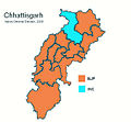 Existing map for the result
 -

-


Article(s): Indian general election, 2009 (Chhattisgarh)
Request:
- There are many things that could be improved about this image (e.g. JPG->SVG, adding constituency names, etc.). But, for now I would like an error in the image to be corrected — a saffron region in the map should be changed to cyan or blue, and vice versa, to reflect the correct election result.
- A map (requiring Adobe Flash plugin) of all the constituencies and results as of 2009 can be found here. Note the locations and colours of 4 - Korba and 9 - Mahasamund in the map therein.
- The articles Mahasamund (Lok Sabha constituency) and Korba (Lok Sabha constituency) also state that Korba was won by INC and Mahasamund by BJP in 2009. The existing image shows Mahasamund as won by INC and Korba as won by BJP. This could have been due to a confusion with the 2004 result [1] when INC won Mahasamund (Lok Sabha constituency). -- Paddu ( talk) 00:10, 4 May 2014 (UTC)
- I took a shoot at creating a new map. However I think the best results would be achieved by extracting regional maps from the national svg map posted above. @ User:Paddu @ User:Maproom - P. S. Burton ( talk) 21:08, 5 June 2014 (UTC)
Graphist opinion(s):
- Done. It was a pretty skundgy image, I have tried not to make it any worse.
Maproom (
talk)
22:39, 25 May 2014 (UTC)
Old Jamestown, MO
Article(s): Old Jamestown, Missouri

Request: Communities of
St. Louis County, Missouri all have a file on each article page like
this, highlighting the location of the community within the county. Since the addition of Old Jamestown as a
CDP in 2010, these files have not been updated to include this new community. I have attempted to contact the original uploaders of these files, but have received no response.
I request all files on articles of St. Louis County communities be updated to include the new community, (including Old Jamestown, Missouri with a highlighted file). I can provide resources if necessary. — Confession0791 talk 17:01, 13 May 2014 (UTC)
- Resources: [2] and this one is zoomable: [3] — Confession0791 talk 15:35, 21 May 2014 (UTC)
Graphist opinion(s):
-
Request taken.
Philg88 ♦
talk
16:08, 21 May 2014 (UTC)
- @
Confession0791: After looking into this, I don't think that your request will work. Based on the scale of the current locator map, Old Jamestown would be a tiny red blob if it were outlined. The
source I had planned to use doesn't show this subdivision as part of MO. Any suggestions?
Philg88 ♦
talk
14:52, 22 May 2014 (UTC)
- If you look at all articles of St. Louis County cities and CDP's, they all appear as "tiny red blobs" on their locator maps. It merely shows the location of the community within the county. —
Confession0791
talk
16:14, 22 May 2014 (UTC)
- OK, I see what the issue is. Leave it with me for a couple of days.
Philg88 ♦
talk
17:44, 22 May 2014 (UTC)
- @ Confession0791: Is that what you mean? Philg88 ♦ talk 08:01, 23 May 2014 (UTC)
- Only issue is the western boundary is more like a 45 degree angle. —
Confession0791
talk
13:35, 23 May 2014 (UTC)
- Western border tweaked accordingly. Let me know if this is OK and I'll update the other maps.
Philg88 ♦
talk
14:18, 23 May 2014 (UTC)
- Pretty good. Remember to leave this community unshaded on the other maps, since it is unincorporated. And thank you. —
Confession0791
talk
14:47, 23 May 2014 (UTC)
- Status update? —
Confession0791
talk
15:48, 29 May 2014 (UTC)
- You mean are the other maps done? No, not yet. I intend to create a new SVG of the districts element of this map with lat/long referencing. It's not a trivial task so please be patient. Cheers,
Philg88 ♦
talk
16:44, 29 May 2014 (UTC)
- Understood. — Confession0791 talk 20:01, 29 May 2014 (UTC)
- You mean are the other maps done? No, not yet. I intend to create a new SVG of the districts element of this map with lat/long referencing. It's not a trivial task so please be patient. Cheers,
Philg88 ♦
talk
16:44, 29 May 2014 (UTC)
- Status update? —
Confession0791
talk
15:48, 29 May 2014 (UTC)
- Pretty good. Remember to leave this community unshaded on the other maps, since it is unincorporated. And thank you. —
Confession0791
talk
14:47, 23 May 2014 (UTC)
- Western border tweaked accordingly. Let me know if this is OK and I'll update the other maps.
Philg88 ♦
talk
14:18, 23 May 2014 (UTC)
- OK, I see what the issue is. Leave it with me for a couple of days.
Philg88 ♦
talk
17:44, 22 May 2014 (UTC)
- If you look at all articles of St. Louis County cities and CDP's, they all appear as "tiny red blobs" on their locator maps. It merely shows the location of the community within the county. —
Confession0791
talk
16:14, 22 May 2014 (UTC)
- @
Confession0791: After looking into this, I don't think that your request will work. Based on the scale of the current locator map, Old Jamestown would be a tiny red blob if it were outlined. The
source I had planned to use doesn't show this subdivision as part of MO. Any suggestions?
Philg88 ♦
talk
14:52, 22 May 2014 (UTC)
Toxostoma curvirostre
Article: Curve-billed Thrasher
Request:Hello! I would like to have the map of the Curve-billed Thrasher revised (I requested a map done on this bird probably a year and a half ago). After doing research, it turns out that it isn't located in California unless you count instances of vagrants. Here is the link: National Geographic Curved-billed Thrasher
Thanks! LeftAire ( talk) 21:22, 13 May 2014 (UTC)
- It would have been a great help for us that do graphic work here if you use the --New request-- link at the top. That provides us with all the code that is necessary for this work to be as easy as possible so please update this request.
- For your request it would also have been great if you linked to the image you wants to have edited. Also please bear in mind that this is your topic, we that do graphic work here have probably zero knowledge on this topic.
- It seems to me you are requesting a map of "Curve-billed Thrasher" what that now is? I can on your link see it's a bird, but you can't have a map of a bird, to me anyway.
- We do graphic work not research so please help us to help you and provide us with all the necessary information. Also write in a way so that anyone understand your purpose and information. I do hope you understand this point of view, thanks. -- Goran tek-en ( talk) 10:15, 14 May 2014 (UTC)
- I think LeftAire wants a map of the range of the Curve-billed Thrasher, copied form the National Geographic article cited above, but not so closely as to be a copyright violation. Maproom ( talk) 16:41, 17 May 2014 (UTC)
- Maproom is correct. I'm sorry I wasn't clear on the directions for what exactly that I had wanted. I didn't get a lot of sleep that day and it showed. Is it any way possible that the map of the range of the Curve-billed Thrasher from the National Geographic page could be closely copied w/o copyright infringement? If so, it would be greatly appreciated. Once again, my apologies. It's been quite a while since I've asked for a map graphic. LeftAire ( talk) 14:08, 19 May 2014 (UTC)
- Done the request to remove California and Nevada from the range, as shown in the cited National Geographic page. I have left the rest of the range alone, particularly Mexico and the blue bits shown in the sea.
Maproom (
talk)
22:56, 25 May 2014 (UTC)
Languages of Indonesia
-
 Indonesia Ethnic Groups Map English
 -
 Indonesian Province

Article(s): Languages of Indonesia
Request:
- Please add province boundary in Indonesia Ethnic Groups Map. -- Kaiyr ( talk) 16:41, 1 May 2014 (UTC)
Graphist opinion(s):
2014 EP constituency maps fix
-
 EP constituencies (already fixed)
 -
 Austria (needs fixing)
 -
 Belgium - German-speaking (needs fixing)
 -
 Belgium - French-speaking (needs fixing)
 -
 Belgium - Dutch-speaking (needs fixing)
 -
 Bulgaria (needs fixing)
...and so on


Article(s): Multiple
Request: I created about 67 maps of each European Parliament constituency (see Category:European_Parliament_constituencies), but after uploading them I realized there are 2 mistakes: Liechtenstein was mistakenly added, and French Southern/Antarctic Territory is not part of the electoral process. Both areas should be grey (Like the good example above). I already corrected all of them once when I changed the Irish constituencies, and I don't have the time to do all of 'em again. Thanks - ArnoldPlaton ( talk) 21:09, 21 May 2014 (UTC)
Graphist opinion(s):
Philippine EEZ update
-
 Philippine EEZ

Article(s): Exclusive economic zone
Request:
- Please update the map according to the new maritime delineation treaty between Indonesia and the Philippines. Created another file if necessary. -- 203.215.121.178 ( talk) 05:10, 24 May 2014 (UTC)
Graphist opinion(s):
Chorley political boundaries.
I downloaded a map and re-hashed it and then re-uploaded it but apparently, this is not a free licence. I was redirected here. Can anyone help? — Preceding unsigned comment added by Darrenjolley ( talk • contribs) 11:26, 28 May 2014 (UTC)
- Where did you download it from? What map was it? Maproom ( talk) 07:49, 30 May 2014 (UTC)
I downloaded it from this site.

- (I have shrunk the image here to a more modest size.)
- This image was uploaded to Wikimedia commons by 'CMLW22', who claimed it as "own work" and released it with a Creative Commons Attribution-ShareAlike 3.0 License. Why do you think think it is not a free licence? Anyway, the Commons Help Desk might be a better place to ask. Maproom ( talk) 21:48, 30 May 2014 (UTC)
| This page is an archive. Do not edit the contents of this page. Please direct any additional comments to the current main page. |
Resolved An interactive map of Wikipedia Education Programs for Outreach wiki
-
Blank map of the world
-
Use this background, better shape and code.
-
Created by NNW ! :)
Article(s): outreach:Education/Programs
Request:
- Dear Map Workshop,
- Some of our community members have asked us to add a map of educational programs on education.wikimedia.org. This is a feature that we agree would be really helpful to have on Outreach wiki. An interactive map, like the one used by Wiki Loves Monuments here, would be even better. I've talked with User:Heatherawalls and User:Ragesoss about this, and we know it's possible, we just don't know how to make it happen ourselves. Heather encouraged me to reach out to the amazing mapmakers here on Commons to see if you may be able to support us in this. Can you? :) Many thanks in advance. All the best, Anna Koval (WMF) ( talk) 21:26, 15 May 2014 (UTC)
Graphist opinion(s):
- Hello
Anna, nice to hear all this. Key factors are :
- Where do you want to implement/display your map ? which website? https://outreach.wikimedia.org I think.
- When do you need it ?
- What is the map scope ? (USA? World?) and list of countries/places to display.
- What is the depth of it (USA general interactive map + interactive map for each state ?)s.
- --
- Different technologies and time frame are possible depending on these answer.
- The IEG:Wikimaps_Atlas I lead is expected to provide such interactive maps around August 2014 for general websites. Implementation into WMF's mediawikis then need approval and deployment.
- Other approaches, while handmade, may be faster to get to you.
- Send us back your starting parameters, we will find you the suitable approach. Cheer.
Yug (
talk)
10:10, 17 May 2014 (UTC)
- Hi
Yug, so happy to hear from you! :)
- Generally, yes, we will use it on outreach.wikimedia.org, but more specifically at outreach.wikimedia.org/wiki/Education/Programs
- How soon can you do it? ;) The sooner the better would be great. But we realize that we are not the only customer at the market. :) Our map scope is:
- the whole World.
- Countries being:
- Hi
Yug, so happy to hear from you! :)
Algeria Argentina Armenia Australia Austria Azerbaijan Bangladesh Belgium Bolivia Brazil Cameroon Canada Catalonia (Amical) Chile Colombia Czech Republic Denmark Ecuador Egypt Estonia Finland France Germany Greece Honduras Hong Kong Hungary India Indonesia Ireland Israel Italy Japan Jordan Kazakhstan Kenya Korea Macedonia Mexico Myanmar Namibia Nepal Netherlands Norway Panama Philippines Poland Portugal Qatar Russia Saudi Arabia Serbia Singapore Slovakia South Africa Spain Sweden Switzerland Taiwan Thailand Tunisia Ukraine United Kingdom United States Uruguay Venezuela Yemen
- World interactive map for each country.
- Ideally, all countries could be clickable. If there is an education program in that country, though, it would be one color, a bright bold color, and clicking it would lead to it's program description page. If there is not an education program in that country yet, it would be another color, a lighter color, like gray or white, and clicking it would lead to a page that says something like: "There's no Wikipedia Education Program yet in this country. But you can help us start one! Here's how..." Does that make sense? :)
- The Wikiatlas project isawesome! Maybe we can be one of your test projects! :)
- Understood. I'm also reaching out to other cartographers, too.
- I hope this is enough information to get started. Let me know if you need more information. Looking forward to working together again! Thanks so much, Yug! :) Anna Koval (WMF) ( talk) 19:22, 17 May 2014 (UTC)
- Ok,to translate this into graphist terms, I think we will have to work with
File:BlankMap-World.svg. I have a feeling of deja vue relate to this world map and interactive features, but I have no clue where I saw that. We could first provide you a static maps with these active countries colored which take a dozen of minutes to do, then look for an interactive solution. As usual, we graphists will try around, but that's really depending on the size of the task and our free time.
Yug
(talk)
21:06, 18 May 2014 (UTC)
- I haven't experience with it, but
imagemap may be the tool we need.
Yug
(talk)
21:39, 18 May 2014 (UTC)
- Does someone knows python ? A guy made a python script to quickly convert svg into imagemaps:
Creating an image map from SVG. He got
this result from a previous wikipedia world map, which is quite impressive.
Yug
(talk)
21:53, 18 May 2014 (UTC)
- Seems there is no countries-of-the-world imagemap in Category:Wikipedia_geographic_image_maps. There are few links on the subject of imagemaps. It seems there is a distinction between HTML-format image maps to wiki image maps. Yug (talk) 22:36, 18 May 2014 (UTC)
- Does someone knows python ? A guy made a python script to quickly convert svg into imagemaps:
Creating an image map from SVG. He got
this result from a previous wikipedia world map, which is quite impressive.
Yug
(talk)
21:53, 18 May 2014 (UTC)
- I haven't experience with it, but
imagemap may be the tool we need.
Yug
(talk)
21:39, 18 May 2014 (UTC)
I think that one should consider this;
- Do we want an image map that can stand alone?
or
- Do we want an image map that is depending on code on the html page itself?
As this image map (to me anyway) should be uploaded to commons and work on any page from where it can be used anywhere (even outside wikimedia) this is a very important point, a stand alone version; free knowledge och free media.
If it's decided it should work anywhere then you can't use code on the html page, everything has to be within the svg file itself.
You can look
at this link for a test.
This test file is not based on a wikimedia server or run thru it's program so that has to be check also, but this is how it works on a normal website: the stand alone version, all within the svg file. --
Goran tek-en (
talk)
06:44, 19 May 2014 (UTC)
-
Request taken by
NNW.: working immediately !
- Done:
Result is there !
- Thank you Thanks so much,
NNW and
Yug. I'm so grateful for your help and so happy about the results. :)
Anna Koval (WMF) (
talk)
20:28, 21 May 2014 (UTC)
Stale Vancouver Island Ranges
-
Mountain ranges on Vancouver Island lacking geographic coordinates
Article(s): Vancouver Island Ranges & dozens of individual mountain pages like Golden Hinde (mountain) Mount Prevost, Mount Tzouhalem
Request:
- 1. Require geographic coordinates for the boundaries of the existing map in order to accurately locate mountains on Vancouver Island on their individual articles. The typical map used is for the entire province of British Columbia which is too large an area. -- Canuckle ( talk) 21:48, 6 April 2014 (UTC)
- 2. Permit users to click on the 16 subranges listed on the map and open the article specific to the subrange. -- Canuckle ( talk) 21:48, 6 April 2014 (UTC)
Graphist opinion(s):
:I'm looking into this now, assuming
you're still interested.
Philg88 ♦
talk
15:02, 23 May 2014 (UTC)
Resolved EU Constituencies of Ireland
![]() Done
Done
Article(s): South (European Parliament constituency), Dublin (European Parliament constituency), Midlands–North-West (European Parliament constituency).
Request:
- The boundaries of the European Constituencies of Ireland changed recently for the upcoming European Parliament election, 2014, so would someone please change the the boundaries of both of the above maps to reflect that, using the map found at http://www.thejournal.ie/european-constituency-boundary-redraw-1099966-Sep2013/ as a guide. Plus while you're at it, maybe you could also create a similar map highlighting the new Midlands–North-West Constituency.
Graphist opinion(s):
I'll take it, since I already did a map on the subject earlier today -
![]() Request taken by
ArnoldPlaton (
talk)
14:27, 18 May 2014 (UTC).
Request taken by
ArnoldPlaton (
talk)
14:27, 18 May 2014 (UTC).
- Done - ArnoldPlaton ( talk) 14:50, 18 May 2014 (UTC)
Stale Update Wikipedia Zero Map
Vgrigas ( talk) 16:12, 28 May 2014 (UTC)
Small edit to error on a map of Boston
-
SVG version
-
PNG version
Article(s): voy:Boston
Request:
- Please change the label "Missionary Hills" to the correct name: " Mission Hill" – sumone10154( talk) 01:04, 30 April 2014 (UTC)
Graphist opinion(s):
Indian general election, 2009 result in Chhattisgarh
-
Existing map for the result
-
-
Article(s): Indian general election, 2009 (Chhattisgarh)
Request:
- There are many things that could be improved about this image (e.g. JPG->SVG, adding constituency names, etc.). But, for now I would like an error in the image to be corrected — a saffron region in the map should be changed to cyan or blue, and vice versa, to reflect the correct election result.
- A map (requiring Adobe Flash plugin) of all the constituencies and results as of 2009 can be found here. Note the locations and colours of 4 - Korba and 9 - Mahasamund in the map therein.
- The articles Mahasamund (Lok Sabha constituency) and Korba (Lok Sabha constituency) also state that Korba was won by INC and Mahasamund by BJP in 2009. The existing image shows Mahasamund as won by INC and Korba as won by BJP. This could have been due to a confusion with the 2004 result [1] when INC won Mahasamund (Lok Sabha constituency). -- Paddu ( talk) 00:10, 4 May 2014 (UTC)
- I took a shoot at creating a new map. However I think the best results would be achieved by extracting regional maps from the national svg map posted above. @ User:Paddu @ User:Maproom - P. S. Burton ( talk) 21:08, 5 June 2014 (UTC)
Graphist opinion(s):
- Done. It was a pretty skundgy image, I have tried not to make it any worse.
Maproom (
talk)
22:39, 25 May 2014 (UTC)
Old Jamestown, MO
Article(s): Old Jamestown, Missouri
Request: Communities of
St. Louis County, Missouri all have a file on each article page like
this, highlighting the location of the community within the county. Since the addition of Old Jamestown as a
CDP in 2010, these files have not been updated to include this new community. I have attempted to contact the original uploaders of these files, but have received no response.
I request all files on articles of St. Louis County communities be updated to include the new community, (including Old Jamestown, Missouri with a highlighted file). I can provide resources if necessary. — Confession0791 talk 17:01, 13 May 2014 (UTC)
- Resources: [2] and this one is zoomable: [3] — Confession0791 talk 15:35, 21 May 2014 (UTC)
Graphist opinion(s):
-
Request taken.
Philg88 ♦
talk
16:08, 21 May 2014 (UTC)
- @
Confession0791: After looking into this, I don't think that your request will work. Based on the scale of the current locator map, Old Jamestown would be a tiny red blob if it were outlined. The
source I had planned to use doesn't show this subdivision as part of MO. Any suggestions?
Philg88 ♦
talk
14:52, 22 May 2014 (UTC)
- If you look at all articles of St. Louis County cities and CDP's, they all appear as "tiny red blobs" on their locator maps. It merely shows the location of the community within the county. —
Confession0791
talk
16:14, 22 May 2014 (UTC)
- OK, I see what the issue is. Leave it with me for a couple of days.
Philg88 ♦
talk
17:44, 22 May 2014 (UTC)
- @ Confession0791: Is that what you mean? Philg88 ♦ talk 08:01, 23 May 2014 (UTC)
- Only issue is the western boundary is more like a 45 degree angle. —
Confession0791
talk
13:35, 23 May 2014 (UTC)
- Western border tweaked accordingly. Let me know if this is OK and I'll update the other maps.
Philg88 ♦
talk
14:18, 23 May 2014 (UTC)
- Pretty good. Remember to leave this community unshaded on the other maps, since it is unincorporated. And thank you. —
Confession0791
talk
14:47, 23 May 2014 (UTC)
- Status update? —
Confession0791
talk
15:48, 29 May 2014 (UTC)
- You mean are the other maps done? No, not yet. I intend to create a new SVG of the districts element of this map with lat/long referencing. It's not a trivial task so please be patient. Cheers,
Philg88 ♦
talk
16:44, 29 May 2014 (UTC)
- Understood. — Confession0791 talk 20:01, 29 May 2014 (UTC)
- You mean are the other maps done? No, not yet. I intend to create a new SVG of the districts element of this map with lat/long referencing. It's not a trivial task so please be patient. Cheers,
Philg88 ♦
talk
16:44, 29 May 2014 (UTC)
- Status update? —
Confession0791
talk
15:48, 29 May 2014 (UTC)
- Pretty good. Remember to leave this community unshaded on the other maps, since it is unincorporated. And thank you. —
Confession0791
talk
14:47, 23 May 2014 (UTC)
- Western border tweaked accordingly. Let me know if this is OK and I'll update the other maps.
Philg88 ♦
talk
14:18, 23 May 2014 (UTC)
- OK, I see what the issue is. Leave it with me for a couple of days.
Philg88 ♦
talk
17:44, 22 May 2014 (UTC)
- If you look at all articles of St. Louis County cities and CDP's, they all appear as "tiny red blobs" on their locator maps. It merely shows the location of the community within the county. —
Confession0791
talk
16:14, 22 May 2014 (UTC)
- @
Confession0791: After looking into this, I don't think that your request will work. Based on the scale of the current locator map, Old Jamestown would be a tiny red blob if it were outlined. The
source I had planned to use doesn't show this subdivision as part of MO. Any suggestions?
Philg88 ♦
talk
14:52, 22 May 2014 (UTC)
Toxostoma curvirostre
Article: Curve-billed Thrasher
Request:Hello! I would like to have the map of the Curve-billed Thrasher revised (I requested a map done on this bird probably a year and a half ago). After doing research, it turns out that it isn't located in California unless you count instances of vagrants. Here is the link: National Geographic Curved-billed Thrasher
Thanks! LeftAire ( talk) 21:22, 13 May 2014 (UTC)
- It would have been a great help for us that do graphic work here if you use the --New request-- link at the top. That provides us with all the code that is necessary for this work to be as easy as possible so please update this request.
- For your request it would also have been great if you linked to the image you wants to have edited. Also please bear in mind that this is your topic, we that do graphic work here have probably zero knowledge on this topic.
- It seems to me you are requesting a map of "Curve-billed Thrasher" what that now is? I can on your link see it's a bird, but you can't have a map of a bird, to me anyway.
- We do graphic work not research so please help us to help you and provide us with all the necessary information. Also write in a way so that anyone understand your purpose and information. I do hope you understand this point of view, thanks. -- Goran tek-en ( talk) 10:15, 14 May 2014 (UTC)
- I think LeftAire wants a map of the range of the Curve-billed Thrasher, copied form the National Geographic article cited above, but not so closely as to be a copyright violation. Maproom ( talk) 16:41, 17 May 2014 (UTC)
- Maproom is correct. I'm sorry I wasn't clear on the directions for what exactly that I had wanted. I didn't get a lot of sleep that day and it showed. Is it any way possible that the map of the range of the Curve-billed Thrasher from the National Geographic page could be closely copied w/o copyright infringement? If so, it would be greatly appreciated. Once again, my apologies. It's been quite a while since I've asked for a map graphic. LeftAire ( talk) 14:08, 19 May 2014 (UTC)
- Done the request to remove California and Nevada from the range, as shown in the cited National Geographic page. I have left the rest of the range alone, particularly Mexico and the blue bits shown in the sea.
Maproom (
talk)
22:56, 25 May 2014 (UTC)
Languages of Indonesia
-
Indonesia Ethnic Groups Map English
-
Indonesian Province
Article(s): Languages of Indonesia
Request:
- Please add province boundary in Indonesia Ethnic Groups Map. -- Kaiyr ( talk) 16:41, 1 May 2014 (UTC)
Graphist opinion(s):
2014 EP constituency maps fix
-
EP constituencies (already fixed)
-
Austria (needs fixing)
-
Belgium - German-speaking (needs fixing)
-
Belgium - French-speaking (needs fixing)
-
Belgium - Dutch-speaking (needs fixing)
-
Bulgaria (needs fixing)
...and so on
Article(s): Multiple
Request: I created about 67 maps of each European Parliament constituency (see Category:European_Parliament_constituencies), but after uploading them I realized there are 2 mistakes: Liechtenstein was mistakenly added, and French Southern/Antarctic Territory is not part of the electoral process. Both areas should be grey (Like the good example above). I already corrected all of them once when I changed the Irish constituencies, and I don't have the time to do all of 'em again. Thanks - ArnoldPlaton ( talk) 21:09, 21 May 2014 (UTC)
Graphist opinion(s):
Philippine EEZ update
-
Philippine EEZ
Article(s): Exclusive economic zone
Request:
- Please update the map according to the new maritime delineation treaty between Indonesia and the Philippines. Created another file if necessary. -- 203.215.121.178 ( talk) 05:10, 24 May 2014 (UTC)
Graphist opinion(s):
Chorley political boundaries.
I downloaded a map and re-hashed it and then re-uploaded it but apparently, this is not a free licence. I was redirected here. Can anyone help? — Preceding unsigned comment added by Darrenjolley ( talk • contribs) 11:26, 28 May 2014 (UTC)
- Where did you download it from? What map was it? Maproom ( talk) 07:49, 30 May 2014 (UTC)
I downloaded it from this site.
- (I have shrunk the image here to a more modest size.)
- This image was uploaded to Wikimedia commons by 'CMLW22', who claimed it as "own work" and released it with a Creative Commons Attribution-ShareAlike 3.0 License. Why do you think think it is not a free licence? Anyway, the Commons Help Desk might be a better place to ask. Maproom ( talk) 21:48, 30 May 2014 (UTC)