| This page is an archive. Do not edit the contents of this page. Please direct any additional comments to the current main page. |

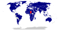
Map of the Parties to the Minamata Convention
{{ resolved}}
- Article(s)
- Minamata Convention on Mercury
- Request
- A map of the Parties to the Minamata Convention would be an important addition to the article. See map and list of Parties [1] [2]. -- Leyo 00:37, 17 November 2021 (UTC)
- An SVG map from c:Category:Maps of signatories of treaties might be used as a template. -- Leyo 15:57, 2 January 2022 (UTC)
- Discussion
![]() Done @
Leyo: Please have a look at
File:Minamata Convention Ratification Map.svg and let me know if I missed something. I also noticed that there some discrepancies between the article and what's stated on their website. I will leave a note on the talk page.
M.Bitton (
talk) 22:52, 28 January 2022 (UTC)
Done @
Leyo: Please have a look at
File:Minamata Convention Ratification Map.svg and let me know if I missed something. I also noticed that there some discrepancies between the article and what's stated on their website. I will leave a note on the talk page.
M.Bitton (
talk) 22:52, 28 January 2022 (UTC)
- Thanks a lot. I didn't find any mistake. I have added the map to all articles (in different languages). -- Leyo 22:42, 31 January 2022 (UTC)
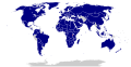
Free School Meals Map
{{ resolved}}
- Article
- School meal
- Request
- Hi i am just wondering can sombody make a world map of nations which have Free school Meals to all kids. These following nations have it, 1 Finland, 2 Estonia, 3 Sweden, 4 India. Those nations can be in green colored and these nation which give only to poor kids 1. UK, 2. South Korea, 3 US, 4 New Zealand. these nations can be colored in yellow. Thanks. La lopi ( talk) 09:50, 27 December 2021 (UTC)
- Discussion
- In the article, the following is stated:
- Sweden, Finland, Estonia and India are among the few countries which provide free school meals to all pupils in compulsory education, regardless of their ability to pay.
- Reliable references would be needed as a basis for creating a map. -- Leyo 12:54, 10 January 2022 (UTC)
- Here
- Finland provides free, catered hot school meals to all pupils from pre-primary to upper secondary education every school day, as guaranteed by the 1948 Basic Education Act.
[1] , Sweden
[2] , South Korea has provided free school lunches to low-income students since the 1980s at the primary and secondary school levels.
[3] , After assuming office, New Zealand's
Labour-led government announced 20,000 children would benefit from school lunches by 2021.
[4]
Jacinda Ardern has said this programme will be dramatically expanded to 200,000 students by the end of 2021 (25% of national school rolls) should she retain office.
[5] , India
Midday Meal Scheme, Estonia
https://arstechnica.com/tech-policy/2019/02/in-estonia-students-transit-school-meals-and-textbooks-are-all-free/ or
https://www.newshub.co.nz/home/world/2021/05/what-countries-provide-free-school-lunches-and-should-new-zealand-follow-suit.html ,
La lopi (
talk) 08:35, 12 January 2022 (UTC)
- Now, you just need to provide references that there are no free school meals in all the other countries … -- Leyo 15:30, 12 January 2022 (UTC)
References
- ^ Finnish National Board of Education (2008). School Meals in Finland: Investment in Learning (PDF) (Report). Finnish National Board of Education. p. 1. Retrieved 20 May 2016.
- ^ Cross, Maria & MacDonald, Barbara (26 January 2009). Nutrition in Institutions. John Wiley & Sons. p. 86. ISBN 978-1444301670.
- ^ Altindag, Duha T.; Baek, Deokrye; Lee, Hong; Merkle, Jessica (2020-02-01). "Free lunch for all? The impact of universal school lunch on student misbehavior". Economics of Education Review. 74: 101945. doi: 10.1016/j.econedurev.2019.101945. ISSN 0272-7757.
- ^ "Jacinda Ardern: Free school lunches for thousands of kids". Magic Radio. 24 February 2020. Retrieved 7 October 2020.
- ^ "Major expansion of school lunch programme". New Zealand Government. 14 May 2020.
- Thats total rubbish, now you being very unfair, first you said give you sources for the nations that have it, i done it now you changing the game by saying this. from what i can see other maps don't need to show other nations stance on the matter with sources. you just color the map for the nation which are on the topic. thats it. On the Wikipedia page for Free
School meal they show that 1 Finland, 2 Estonia, 3 Sweden, 4 India have it. while these nation which give only to poor kids in low income familys. 1. UK, 2. South Korea, 3 US, 4 New Zealand. the page doesnt talk about every single nation in the world all 190 nations. you being total unfair, changing the goal post. if you don;t want to do the map, fine but sombody else should.
La lopi (
talk) 07:10, 13 January 2022 (UTC)
- I wrote
Reliable references would be needed as a basis for creating a map., i.e. I was not referring to positive proofs only. - In fact there might be a number of other countries where free school meals are being provided. On that basis, I really don't think there should be a map in the article. -- Leyo 13:32, 13 January 2022 (UTC)
- I wrote
Request Relief Rheingau
{{ resolved}}
-
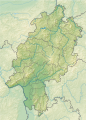 Hesse relief

- Article(s)
- Verband Deutscher Prädikatsweingüter
- Rheingau
- Request
- I don't know exactly, if such a map already exists. My request is, to create a detail relief map of the Rheingau wine region. This can be done by clipping the Hesse relief map. The result should be in the Module:Location map/data/ section. I want to add the coordinates of Wineries in this region.
- My attempts were not very satisfying (it needs detail in the Rheingau region):

 BassermannBeckerBergdoltBernhartBürklin-Wolfvon BuhlChristmannHenningerKnipserKranzMeßmerMosbacherMuglerPfeffingenRebholzRingsSchaeferMingesWehrheimWinningEmrich-SchönleberKruger-RumpfSchäfer-FröhlichSchäferSalmDönnhoffBuschChristoffelFischerLe GallaisGeltz-ZillikenGrans-FassianFritz HaagWilli HaagHaartHerrenbergHeymann-LöwensteinHövelKarthäuserhofKnebelKesselstattAcham-MaginLauerLieserLoosenScharzhofGrünhausMilzOthegravenPiedmontPrümSaarsteinSchaeferThanischUrbans-HofHospitienVolxemWagnerWegelerAntonyBattenfeldBischelBeckerGroebeGunderlochGutzlerKellerKühlingNeusRappenhofSchätzelWeinbaudomäneWagner-StempelWesterhausWittmannAllendorfBarthBelzJungDiefenhardtEberbachErbslöhEserFendelStraßenmühleHochschule GeisenheimFreimuthMüllerHammHessenHupfeldJohannisbergKaufmannKesslerKnyphausenKönigKroneKühnKünstlerKunzLeitzLöwensteinOettingerPrinzQuerbachRessSchönleberSpreitzerVollradsWernerAdeneuerBurggartenDeutzerwieseKreuzbergMeyerStoddenBastianJostLanius-KnabMüllerRatzenbergerFitz-RitterHermannsbergWinterMembers Verband Deutscher Prädikatsweingüter, Rhineland-Palatinate

- EDIT: I found an alternative: OSM location map
Request: South Africa

- Article(s)
- International reactions to the 2022 Russian invasion of Ukraine
- Request
- Hi i am just wondering could sombody fix this map, South Africa is marked as blue/Countries that have condemned the invasion. but all the Sources that i have found clearly shows that South Africa is Countries that have maintained a neutral stance. Same thing as well for United Arab Emirates they have taken a neutral stance as well. Thanks. La lopi ( talk) 02:23, 3 March 2022 (UTC)
- Discussion
{{ resolved}}
Request: European Union map with highlighted Europe continent
{{ Resolved}}
-
 Orthographic projection map of the European Union (in green), without Europe highlighted (in dark grey)
 -
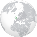 Orthographic projection map of the United Kingdom (in green), with Europe highlighted (in dark grey)
 -
 Orthographic projection map of Europe (in green). The continental boundary to Asia as indicated is the standard convention following the Caucasus crest, the Ural River and the Urals Mountains to the Sea of Kara
 -
 New map

.svg)


- Article(s)
- European Union
- Request
- Please develop orthographic projection map of the European Union with no national borders, in green (as the one above), but with the European continent highlighted in dark grey. This is the convention done for other articles. Given that the European Union territory is mostly located in Europe, I think it makes sense to include this for visualization. Thank you in advance! -- ~ Arkhandar ( message me) 11:31, 3 March 2022 (UTC)
- Discussion
 Done @
Arkhandar: Please have a look at
File:Europe and the European Union.svg and let me know if I missed something.
M.Bitton (
talk) 14:11, 3 March 2022 (UTC)
Done @
Arkhandar: Please have a look at
File:Europe and the European Union.svg and let me know if I missed something.
M.Bitton (
talk) 14:11, 3 March 2022 (UTC)
- @ M.Bitton: Thanks for the quick answer! Would it be possible to use the same color convention as in the UK image. I think the dark grey looks a bit too dark, and it might mislead the readers. ~ Arkhandar ( message me) 19:44, 3 March 2022 (UTC)
- Would it make sense to use the EU definition of Europe, as in which states they'll potentially accept as members, rather than the geographic convention? Or is that insufficiently defined?
— kwami (
talk) 22:00, 3 March 2022 (UTC)
- It depends on what they want to do with it (they didn't say).
M.Bitton (
talk) 23:20, 3 March 2022 (UTC)
- In your map (for reasons I do not understand), the European territory of Georgia, highlighted from the original source maps, has disappeared, while in your version of the map it is missing (although the territory of Azerbaijan north of the Greater Caucasus is circled in you).
- I already pointed out this factual error to you in the discussion, however, for some reason you did not consider it important, referring to the request (most likely, you simply did not understand my remark).
Рагин1987 (
talk) 11:48, 9 September 2022 (UTC)
- Take a close look at Georgia in this map ( https://commons.wikimedia.org/wiki/File:Europe-UK_(orthographic_projection).svg), and you will understand what I am talking about. Рагин1987 ( talk) 11:59, 9 September 2022 (UTC)
- @ Kwamikagami:I think that in Wikipedia it's safer to go with the geographical definition as it's properly sourced by third-parties, and it follows the convention used by other articles. ~ Arkhandar ( message me) 09:59, 4 March 2022 (UTC)
- It depends on what they want to do with it (they didn't say).
M.Bitton (
talk) 23:20, 3 March 2022 (UTC)
Creation of an svg file for "African" foreign relations
-
 Diplomatic relations of the Comoros
 -
 Diplomatic relations of the Central African Republic
 -
 Diplomatic relations of Chad
 -
 Diplomatic relations of Burundi
 -
 Diplomatic relations of Eritrea
 -
 Diplomatic relations of Guinea-Bissau
 -
 Diplomatic relations of Lesotho
 -
 Diplomatic relations of São Tomé and Príncipe
 -
 Diplomatic relations of the Gambia


.svg)
I request for these file to be created:
- File:Diplomatic relations of Burundi.svg
- File:Diplomatic relations of the Central African Republic.svg
- File:Diplomatic relations of Chad.svg
- File:Diplomatic relations of the Comoros.svg
Utkarsh555 10:27, 5 March 2022 (UTC)
-
 Request taken by
M.Bitton (
talk) 00:06, 6 March 2022 (UTC).
Request taken by
M.Bitton (
talk) 00:06, 6 March 2022 (UTC). - @
Utkarsh555: A quick question: the maps have been based on the "Foreign relations of ..." articles. Is that what you had in mind?
M.Bitton (
talk) 16:01, 7 March 2022 (UTC)
- @
M.Bitton Yep, absolutely.
Utkarsh555 16:03, 7 March 2022 (UTC)
- @
M.Bitton Thanks for taking the work, but i have some additional file proposals as well:
- File:Diplomatic relations of Equatorial Guinea.svg
- File:Diplomatic relations of Eritrea.svg
- File:Diplomatic relations of Eswatini.svg (or "...." Of Swaziland.svg)
- File:Diplomatic relations of the Gambia.svg (or "...." Of Gambia.svg)
- File:Diplomatic relations of Guinea-Bissau.svg
- File:Diplomatic relations of Lesotho.svg
- File:Diplomatic relations of Niger.svg
- File:Diplomatic relations of São Tomé and Príncipe.svg
- @
M.Bitton Thanks for taking the work, but i have some additional file proposals as well:
- Utkarsh555 16:03, 7 March 2022 (UTC)
- And (please don't mind, do them at your pace, your time) some left overs here:
- Utkarsh555 16:29, 7 March 2022 (UTC)
- @
M.Bitton Yep, absolutely.
Utkarsh555 16:03, 7 March 2022 (UTC)
![]() Done @
Utkarsh555: Please do check the maps and let me know if I missed anything.
M.Bitton (
talk) 23:50, 8 March 2022 (UTC)
Done @
Utkarsh555: Please do check the maps and let me know if I missed anything.
M.Bitton (
talk) 23:50, 8 March 2022 (UTC)
- @ M.Bitton thank you very much sire! I am glad that you did created the maps. Sir, I would like, if you could do the same for the rest, as I have mentioned then in the replies. I would be very grateful for that!
- Once again sire, thank you!
Utkarsh555 09:54, 9 March 2022 (UTC)
- @
Utkarsh555: Please note that while these maps reflect what's on the articles they're based on, they are not necessarily accurate since the articles themselves are clearly incomplete and need a lot of work. For instance: the idea that
Togo has diplomatic relations with only two African countries doesn't make sense (the finished map that I haven't uploaded makes the situation look much worse). The same goes for Eswatini and Sierra Leone, whose articles are confusing.
M.Bitton (
talk) 01:08, 11 March 2022 (UTC)
- @ M.Bitton Yes, I fully understand that. The relations would also be dependent on the geopolitical conditions. I completely agree. Meanwhile of the map for Togo, you can still work on it. Believe me, i have seen much weirder maps, on wikipedia. You did a great job! I appreciate you! Utkarsh555 04:06, 11 March 2022 (UTC)
- @
Utkarsh555: Please note that while these maps reflect what's on the articles they're based on, they are not necessarily accurate since the articles themselves are clearly incomplete and need a lot of work. For instance: the idea that
Togo has diplomatic relations with only two African countries doesn't make sense (the finished map that I haven't uploaded makes the situation look much worse). The same goes for Eswatini and Sierra Leone, whose articles are confusing.
M.Bitton (
talk) 01:08, 11 March 2022 (UTC)
{{ resolved}}
File removed
@ M.Bitton Sir, while reviewing pages of African countries' foreign relations, I came across the foreign relations of Chad. I had previously added the svg file, but then it was removed by another user, Mr @ Aquintero82, stating that the country had more relations than stated through the map. I know, you warned me that these files might not be accurate, but if you could revise/check again, then i would be grateful for that. Utkarsh555 04:43, 11 March 2022 (UTC)
- It would be prudent to not create maps based on what is mentioned solely within the articles. Anyone can edit a Wikipedia article, but not every dedicates time to adding content to each article.
User:Aquintero82, (
talk), 21:27, 10 March 2022 (UTC)
- @ Aquintero82 but sir, can't it be done for a rough reference as well? Utkarsh555 08:24, 11 March 2022 (UTC)
- No, because it is not accurate. It would be providing a false impression that the countries highlighted are the only countries that that nation has diplomatic relations with. In today's world, most nations have diplomatic relations with the majority of nations.
User:Aquintero82, (
talk), 06:24, 11 March 2022 (UTC)
- @ Aquintero82 Well ,i am not even a beginner of how to develop an svg file. If possible by you [as well], then can you upload a new file for it? Utkarsh555 16:47, 11 March 2022 (UTC)
@ Utkarsh555: The maps you pushed M.Bitton to create are inaccurate since they only consider the info on the "foreign relations of x" articles, but my question is why are you so impatient? I've been working on these maps since 2019 and it takes time and a lot of researching. There was a reason that there were no maps for Chad, Comoros, Sao Tome and Principe, Lesotho, the Gambia and so on. These maps need to be fixed. -- Semsûrî ( talk) 18:25, 11 March 2022 (UTC)
- @Semsûrî: To be fair to them, all they did is ask if someone could create maps for articles that nobody seems to care about. If more editors start paying attention to those articles as a result of their action, then it hasn't been in vain.
- @Utkarsh555: As mentioned previously, the core of the problem lies with the articles (the maps are simply highlighting the issues). My advice to you is to forget about the maps for now and to concentrate on improving the articles (i.e., on fixing the problem). Once done, the maps can easily be updated to reflect the changes. M.Bitton ( talk) 00:09, 12 March 2022 (UTC)
- @ Semsûrî When you say that "i pushed @ M.Bitton", it stinged me. I had simply placed a request. If i had the complete knowledge, then i would have restrained myself. Or if even as i placed the request, then some user must have told me the truth, and deny it. But instead of that, i felt elated when my request was taken, something epic phenomina that happens to be rarely on wikipedia with me. And in flow i placed some more such requests. These events drain me out of editing or researching and expanding articles. Utkarsh555 07:26, 12 March 2022 (UTC)
- At this point all we can do is to help make the maps more accurate. @
M.Bitton: I've expanded
Foreign relations of Burundi extensively, please take a look. Also, thanks for changing the colors at my request but I think its better to use this map as a template
File:BlankMap-World-Sovereign Nations.svg since it connects territories to mainland (for example will color Greenland with Denmark) and gives a micro-state like Liechtenstein a chance of being visible. --
Semsûrî (
talk) 09:59, 12 March 2022 (UTC)
- @ Semsûrî: Thank you for expanding the article. I have updated the map accordingly (you'll find that the tweaked version is probably closer to what you have in mind). I'll let you know about the base map once I've had the chance to compare the two, but in the meantime, please don't hesitate to update the other maps as you expand their respective articles. Further discussions should probably take place on Commons.
- @
Utkarsh555: Thanks to you, a bunch of articles are being improved. If you're happy with the outcome, please let me know so that I can mark the request as {{tl|resolved}}.
M.Bitton (
talk) 00:51, 14 March 2022 (UTC)
- @ M.Bitton @ Semsûrî I am satisfied, glad, happy [what ever you call] that i contributed and restarted the improvement. I was actually surprised that my own country's foreign relation page was not updated since the important events had took place, for eg, the contents regarding to the latest developments in subpage for China was heavily added/edited by me.
- I thought that every country's foreign relations page was up to date, and that my country's page was the only one to lag behind. So, i spend a brief amount of time to it. Utkarsh555 04:29, 14 March 2022 (UTC)
- At this point all we can do is to help make the maps more accurate. @
M.Bitton: I've expanded
Foreign relations of Burundi extensively, please take a look. Also, thanks for changing the colors at my request but I think its better to use this map as a template
File:BlankMap-World-Sovereign Nations.svg since it connects territories to mainland (for example will color Greenland with Denmark) and gives a micro-state like Liechtenstein a chance of being visible. --
Semsûrî (
talk) 09:59, 12 March 2022 (UTC)
{{ resolved}}
| This page is an archive. Do not edit the contents of this page. Please direct any additional comments to the current main page. |
Map of the Parties to the Minamata Convention
{{ resolved}}
- Article(s)
- Minamata Convention on Mercury
- Request
- A map of the Parties to the Minamata Convention would be an important addition to the article. See map and list of Parties [1] [2]. -- Leyo 00:37, 17 November 2021 (UTC)
- An SVG map from c:Category:Maps of signatories of treaties might be used as a template. -- Leyo 15:57, 2 January 2022 (UTC)
- Discussion
![]() Done @
Leyo: Please have a look at
File:Minamata Convention Ratification Map.svg and let me know if I missed something. I also noticed that there some discrepancies between the article and what's stated on their website. I will leave a note on the talk page.
M.Bitton (
talk) 22:52, 28 January 2022 (UTC)
Done @
Leyo: Please have a look at
File:Minamata Convention Ratification Map.svg and let me know if I missed something. I also noticed that there some discrepancies between the article and what's stated on their website. I will leave a note on the talk page.
M.Bitton (
talk) 22:52, 28 January 2022 (UTC)
- Thanks a lot. I didn't find any mistake. I have added the map to all articles (in different languages). -- Leyo 22:42, 31 January 2022 (UTC)
Free School Meals Map
{{ resolved}}
- Article
- School meal
- Request
- Hi i am just wondering can sombody make a world map of nations which have Free school Meals to all kids. These following nations have it, 1 Finland, 2 Estonia, 3 Sweden, 4 India. Those nations can be in green colored and these nation which give only to poor kids 1. UK, 2. South Korea, 3 US, 4 New Zealand. these nations can be colored in yellow. Thanks. La lopi ( talk) 09:50, 27 December 2021 (UTC)
- Discussion
- In the article, the following is stated:
- Sweden, Finland, Estonia and India are among the few countries which provide free school meals to all pupils in compulsory education, regardless of their ability to pay.
- Reliable references would be needed as a basis for creating a map. -- Leyo 12:54, 10 January 2022 (UTC)
- Here
- Finland provides free, catered hot school meals to all pupils from pre-primary to upper secondary education every school day, as guaranteed by the 1948 Basic Education Act.
[1] , Sweden
[2] , South Korea has provided free school lunches to low-income students since the 1980s at the primary and secondary school levels.
[3] , After assuming office, New Zealand's
Labour-led government announced 20,000 children would benefit from school lunches by 2021.
[4]
Jacinda Ardern has said this programme will be dramatically expanded to 200,000 students by the end of 2021 (25% of national school rolls) should she retain office.
[5] , India
Midday Meal Scheme, Estonia
https://arstechnica.com/tech-policy/2019/02/in-estonia-students-transit-school-meals-and-textbooks-are-all-free/ or
https://www.newshub.co.nz/home/world/2021/05/what-countries-provide-free-school-lunches-and-should-new-zealand-follow-suit.html ,
La lopi (
talk) 08:35, 12 January 2022 (UTC)
- Now, you just need to provide references that there are no free school meals in all the other countries … -- Leyo 15:30, 12 January 2022 (UTC)
References
- ^ Finnish National Board of Education (2008). School Meals in Finland: Investment in Learning (PDF) (Report). Finnish National Board of Education. p. 1. Retrieved 20 May 2016.
- ^ Cross, Maria & MacDonald, Barbara (26 January 2009). Nutrition in Institutions. John Wiley & Sons. p. 86. ISBN 978-1444301670.
- ^ Altindag, Duha T.; Baek, Deokrye; Lee, Hong; Merkle, Jessica (2020-02-01). "Free lunch for all? The impact of universal school lunch on student misbehavior". Economics of Education Review. 74: 101945. doi: 10.1016/j.econedurev.2019.101945. ISSN 0272-7757.
- ^ "Jacinda Ardern: Free school lunches for thousands of kids". Magic Radio. 24 February 2020. Retrieved 7 October 2020.
- ^ "Major expansion of school lunch programme". New Zealand Government. 14 May 2020.
- Thats total rubbish, now you being very unfair, first you said give you sources for the nations that have it, i done it now you changing the game by saying this. from what i can see other maps don't need to show other nations stance on the matter with sources. you just color the map for the nation which are on the topic. thats it. On the Wikipedia page for Free
School meal they show that 1 Finland, 2 Estonia, 3 Sweden, 4 India have it. while these nation which give only to poor kids in low income familys. 1. UK, 2. South Korea, 3 US, 4 New Zealand. the page doesnt talk about every single nation in the world all 190 nations. you being total unfair, changing the goal post. if you don;t want to do the map, fine but sombody else should.
La lopi (
talk) 07:10, 13 January 2022 (UTC)
- I wrote
Reliable references would be needed as a basis for creating a map., i.e. I was not referring to positive proofs only. - In fact there might be a number of other countries where free school meals are being provided. On that basis, I really don't think there should be a map in the article. -- Leyo 13:32, 13 January 2022 (UTC)
- I wrote
Request Relief Rheingau
{{ resolved}}
-
Hesse relief
- Article(s)
- Verband Deutscher Prädikatsweingüter
- Rheingau
- Request
- I don't know exactly, if such a map already exists. My request is, to create a detail relief map of the Rheingau wine region. This can be done by clipping the Hesse relief map. The result should be in the Module:Location map/data/ section. I want to add the coordinates of Wineries in this region.
- My attempts were not very satisfying (it needs detail in the Rheingau region):
- BassermannBeckerBergdoltBernhartBürklin-Wolfvon BuhlChristmannHenningerKnipserKranzMeßmerMosbacherMuglerPfeffingenRebholzRingsSchaeferMingesWehrheimWinningEmrich-SchönleberKruger-RumpfSchäfer-FröhlichSchäferSalmDönnhoffBuschChristoffelFischerLe GallaisGeltz-ZillikenGrans-FassianFritz HaagWilli HaagHaartHerrenbergHeymann-LöwensteinHövelKarthäuserhofKnebelKesselstattAcham-MaginLauerLieserLoosenScharzhofGrünhausMilzOthegravenPiedmontPrümSaarsteinSchaeferThanischUrbans-HofHospitienVolxemWagnerWegelerAntonyBattenfeldBischelBeckerGroebeGunderlochGutzlerKellerKühlingNeusRappenhofSchätzelWeinbaudomäneWagner-StempelWesterhausWittmannAllendorfBarthBelzJungDiefenhardtEberbachErbslöhEserFendelStraßenmühleHochschule GeisenheimFreimuthMüllerHammHessenHupfeldJohannisbergKaufmannKesslerKnyphausenKönigKroneKühnKünstlerKunzLeitzLöwensteinOettingerPrinzQuerbachRessSchönleberSpreitzerVollradsWernerAdeneuerBurggartenDeutzerwieseKreuzbergMeyerStoddenBastianJostLanius-KnabMüllerRatzenbergerFitz-RitterHermannsbergWinterMembers Verband Deutscher Prädikatsweingüter, Rhineland-Palatinate
- EDIT: I found an alternative: OSM location map
Request: South Africa
- Article(s)
- International reactions to the 2022 Russian invasion of Ukraine
- Request
- Hi i am just wondering could sombody fix this map, South Africa is marked as blue/Countries that have condemned the invasion. but all the Sources that i have found clearly shows that South Africa is Countries that have maintained a neutral stance. Same thing as well for United Arab Emirates they have taken a neutral stance as well. Thanks. La lopi ( talk) 02:23, 3 March 2022 (UTC)
- Discussion
{{ resolved}}
Request: European Union map with highlighted Europe continent
{{ Resolved}}
-
Orthographic projection map of the European Union (in green), without Europe highlighted (in dark grey)
-
Orthographic projection map of the United Kingdom (in green), with Europe highlighted (in dark grey)
-
Orthographic projection map of Europe (in green). The continental boundary to Asia as indicated is the standard convention following the Caucasus crest, the Ural River and the Urals Mountains to the Sea of Kara
-
New map
- Article(s)
- European Union
- Request
- Please develop orthographic projection map of the European Union with no national borders, in green (as the one above), but with the European continent highlighted in dark grey. This is the convention done for other articles. Given that the European Union territory is mostly located in Europe, I think it makes sense to include this for visualization. Thank you in advance! -- ~ Arkhandar ( message me) 11:31, 3 March 2022 (UTC)
- Discussion
- Done @
Arkhandar: Please have a look at
File:Europe and the European Union.svg and let me know if I missed something.
M.Bitton (
talk) 14:11, 3 March 2022 (UTC)
- @ M.Bitton: Thanks for the quick answer! Would it be possible to use the same color convention as in the UK image. I think the dark grey looks a bit too dark, and it might mislead the readers. ~ Arkhandar ( message me) 19:44, 3 March 2022 (UTC)
- Would it make sense to use the EU definition of Europe, as in which states they'll potentially accept as members, rather than the geographic convention? Or is that insufficiently defined?
— kwami (
talk) 22:00, 3 March 2022 (UTC)
- It depends on what they want to do with it (they didn't say).
M.Bitton (
talk) 23:20, 3 March 2022 (UTC)
- In your map (for reasons I do not understand), the European territory of Georgia, highlighted from the original source maps, has disappeared, while in your version of the map it is missing (although the territory of Azerbaijan north of the Greater Caucasus is circled in you).
- I already pointed out this factual error to you in the discussion, however, for some reason you did not consider it important, referring to the request (most likely, you simply did not understand my remark).
Рагин1987 (
talk) 11:48, 9 September 2022 (UTC)
- Take a close look at Georgia in this map ( https://commons.wikimedia.org/wiki/File:Europe-UK_(orthographic_projection).svg), and you will understand what I am talking about. Рагин1987 ( talk) 11:59, 9 September 2022 (UTC)
- @ Kwamikagami:I think that in Wikipedia it's safer to go with the geographical definition as it's properly sourced by third-parties, and it follows the convention used by other articles. ~ Arkhandar ( message me) 09:59, 4 March 2022 (UTC)
- It depends on what they want to do with it (they didn't say).
M.Bitton (
talk) 23:20, 3 March 2022 (UTC)
Creation of an svg file for "African" foreign relations
-
Diplomatic relations of the Comoros
-
Diplomatic relations of the Central African Republic
-
Diplomatic relations of Chad
-
Diplomatic relations of Burundi
-
Diplomatic relations of Eritrea
-
Diplomatic relations of Guinea-Bissau
-
Diplomatic relations of Lesotho
-
Diplomatic relations of São Tomé and Príncipe
-
Diplomatic relations of the Gambia
I request for these file to be created:
- File:Diplomatic relations of Burundi.svg
- File:Diplomatic relations of the Central African Republic.svg
- File:Diplomatic relations of Chad.svg
- File:Diplomatic relations of the Comoros.svg
Utkarsh555 10:27, 5 March 2022 (UTC)
-
Request taken by
M.Bitton (
talk) 00:06, 6 March 2022 (UTC).
- @
Utkarsh555: A quick question: the maps have been based on the "Foreign relations of ..." articles. Is that what you had in mind?
M.Bitton (
talk) 16:01, 7 March 2022 (UTC)
- @
M.Bitton Yep, absolutely.
Utkarsh555 16:03, 7 March 2022 (UTC)
- @
M.Bitton Thanks for taking the work, but i have some additional file proposals as well:
- File:Diplomatic relations of Equatorial Guinea.svg
- File:Diplomatic relations of Eritrea.svg
- File:Diplomatic relations of Eswatini.svg (or "...." Of Swaziland.svg)
- File:Diplomatic relations of the Gambia.svg (or "...." Of Gambia.svg)
- File:Diplomatic relations of Guinea-Bissau.svg
- File:Diplomatic relations of Lesotho.svg
- File:Diplomatic relations of Niger.svg
- File:Diplomatic relations of São Tomé and Príncipe.svg
- @
M.Bitton Thanks for taking the work, but i have some additional file proposals as well:
- Utkarsh555 16:03, 7 March 2022 (UTC)
- And (please don't mind, do them at your pace, your time) some left overs here:
- Utkarsh555 16:29, 7 March 2022 (UTC)
- @
M.Bitton Yep, absolutely.
Utkarsh555 16:03, 7 March 2022 (UTC)
![]() Done @
Utkarsh555: Please do check the maps and let me know if I missed anything.
M.Bitton (
talk) 23:50, 8 March 2022 (UTC)
Done @
Utkarsh555: Please do check the maps and let me know if I missed anything.
M.Bitton (
talk) 23:50, 8 March 2022 (UTC)
- @ M.Bitton thank you very much sire! I am glad that you did created the maps. Sir, I would like, if you could do the same for the rest, as I have mentioned then in the replies. I would be very grateful for that!
- Once again sire, thank you!
Utkarsh555 09:54, 9 March 2022 (UTC)
- @
Utkarsh555: Please note that while these maps reflect what's on the articles they're based on, they are not necessarily accurate since the articles themselves are clearly incomplete and need a lot of work. For instance: the idea that
Togo has diplomatic relations with only two African countries doesn't make sense (the finished map that I haven't uploaded makes the situation look much worse). The same goes for Eswatini and Sierra Leone, whose articles are confusing.
M.Bitton (
talk) 01:08, 11 March 2022 (UTC)
- @ M.Bitton Yes, I fully understand that. The relations would also be dependent on the geopolitical conditions. I completely agree. Meanwhile of the map for Togo, you can still work on it. Believe me, i have seen much weirder maps, on wikipedia. You did a great job! I appreciate you! Utkarsh555 04:06, 11 March 2022 (UTC)
- @
Utkarsh555: Please note that while these maps reflect what's on the articles they're based on, they are not necessarily accurate since the articles themselves are clearly incomplete and need a lot of work. For instance: the idea that
Togo has diplomatic relations with only two African countries doesn't make sense (the finished map that I haven't uploaded makes the situation look much worse). The same goes for Eswatini and Sierra Leone, whose articles are confusing.
M.Bitton (
talk) 01:08, 11 March 2022 (UTC)
{{ resolved}}
File removed
@ M.Bitton Sir, while reviewing pages of African countries' foreign relations, I came across the foreign relations of Chad. I had previously added the svg file, but then it was removed by another user, Mr @ Aquintero82, stating that the country had more relations than stated through the map. I know, you warned me that these files might not be accurate, but if you could revise/check again, then i would be grateful for that. Utkarsh555 04:43, 11 March 2022 (UTC)
- It would be prudent to not create maps based on what is mentioned solely within the articles. Anyone can edit a Wikipedia article, but not every dedicates time to adding content to each article.
User:Aquintero82, (
talk), 21:27, 10 March 2022 (UTC)
- @ Aquintero82 but sir, can't it be done for a rough reference as well? Utkarsh555 08:24, 11 March 2022 (UTC)
- No, because it is not accurate. It would be providing a false impression that the countries highlighted are the only countries that that nation has diplomatic relations with. In today's world, most nations have diplomatic relations with the majority of nations.
User:Aquintero82, (
talk), 06:24, 11 March 2022 (UTC)
- @ Aquintero82 Well ,i am not even a beginner of how to develop an svg file. If possible by you [as well], then can you upload a new file for it? Utkarsh555 16:47, 11 March 2022 (UTC)
@ Utkarsh555: The maps you pushed M.Bitton to create are inaccurate since they only consider the info on the "foreign relations of x" articles, but my question is why are you so impatient? I've been working on these maps since 2019 and it takes time and a lot of researching. There was a reason that there were no maps for Chad, Comoros, Sao Tome and Principe, Lesotho, the Gambia and so on. These maps need to be fixed. -- Semsûrî ( talk) 18:25, 11 March 2022 (UTC)
- @Semsûrî: To be fair to them, all they did is ask if someone could create maps for articles that nobody seems to care about. If more editors start paying attention to those articles as a result of their action, then it hasn't been in vain.
- @Utkarsh555: As mentioned previously, the core of the problem lies with the articles (the maps are simply highlighting the issues). My advice to you is to forget about the maps for now and to concentrate on improving the articles (i.e., on fixing the problem). Once done, the maps can easily be updated to reflect the changes. M.Bitton ( talk) 00:09, 12 March 2022 (UTC)
- @ Semsûrî When you say that "i pushed @ M.Bitton", it stinged me. I had simply placed a request. If i had the complete knowledge, then i would have restrained myself. Or if even as i placed the request, then some user must have told me the truth, and deny it. But instead of that, i felt elated when my request was taken, something epic phenomina that happens to be rarely on wikipedia with me. And in flow i placed some more such requests. These events drain me out of editing or researching and expanding articles. Utkarsh555 07:26, 12 March 2022 (UTC)
- At this point all we can do is to help make the maps more accurate. @
M.Bitton: I've expanded
Foreign relations of Burundi extensively, please take a look. Also, thanks for changing the colors at my request but I think its better to use this map as a template
File:BlankMap-World-Sovereign Nations.svg since it connects territories to mainland (for example will color Greenland with Denmark) and gives a micro-state like Liechtenstein a chance of being visible. --
Semsûrî (
talk) 09:59, 12 March 2022 (UTC)
- @ Semsûrî: Thank you for expanding the article. I have updated the map accordingly (you'll find that the tweaked version is probably closer to what you have in mind). I'll let you know about the base map once I've had the chance to compare the two, but in the meantime, please don't hesitate to update the other maps as you expand their respective articles. Further discussions should probably take place on Commons.
- @
Utkarsh555: Thanks to you, a bunch of articles are being improved. If you're happy with the outcome, please let me know so that I can mark the request as {{tl|resolved}}.
M.Bitton (
talk) 00:51, 14 March 2022 (UTC)
- @ M.Bitton @ Semsûrî I am satisfied, glad, happy [what ever you call] that i contributed and restarted the improvement. I was actually surprised that my own country's foreign relation page was not updated since the important events had took place, for eg, the contents regarding to the latest developments in subpage for China was heavily added/edited by me.
- I thought that every country's foreign relations page was up to date, and that my country's page was the only one to lag behind. So, i spend a brief amount of time to it. Utkarsh555 04:29, 14 March 2022 (UTC)
- At this point all we can do is to help make the maps more accurate. @
M.Bitton: I've expanded
Foreign relations of Burundi extensively, please take a look. Also, thanks for changing the colors at my request but I think its better to use this map as a template
File:BlankMap-World-Sovereign Nations.svg since it connects territories to mainland (for example will color Greenland with Denmark) and gives a micro-state like Liechtenstein a chance of being visible. --
Semsûrî (
talk) 09:59, 12 March 2022 (UTC)
{{ resolved}}