| This page is an archive. Do not edit the contents of this page. Please direct any additional comments to the current main page. |

Poor counties
-
 U.S. counties
 -
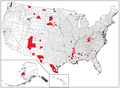 U.S. counties, poor 1
 -
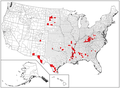 U.S. counties, poor 2


Article(s): List of lowest-income counties in the United States
Request:
- Please make SVGs of the PNG maps. I think it's a simple matter of coloring the right counties. The list of low-income counties has charts showing the counties, so you don't need to try to guess which counties to mark in the SVG files. 2001:18E8:2:28CA:F000:0:0:CB89 ( talk) 17:56, 9 June 2014 (UTC)
Graphist opinion(s):
 Done
Done
-
 U.S. counties, poor 1
 -
 U.S. counties, poor 2


Uploaded and placed in the article. Rcsprinter123 (gossip) @ 10:21, 21 August 2014 (UTC)
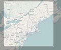
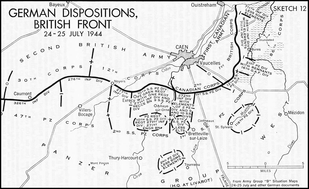
Map for Second Battle of the Odon
Gallery
-
 Draft #2
 -
 Operations Greenwood and Pomegranate


Article(s): Second Battle of the Odon
Request:
- The above article is lacking a map placing the battle in context. The above links, link to a map (from the below source) that at least partially addresses the issue. Due to the lack of copyright information, the map itself cannot be directly uploaded. Furthermore, a second map is on the reserve and it partially shows through on the photos.
- It would be great if someone would be able to knock up a map to support this article, based off the above images: showing the movement of the frontline, the relevant landmarks, Allied and German units, and the general areas of attack (the thrust marks). EnigmaMcmxc ( talk) 00:34, 13 June 2014 (UTC)
Source
- Randel, R.A., Major P. B. (2006) [1945]. A short history of 30 Corps in the European Campaign 1944–1945. MLRS Books.
ISBN
978-1-905973-69-9.
{{
cite book}}
: Unknown parameter|coauthors=ignored (|author=suggested) ( help)
Graphist opinion(s):
-
 Request taken. Give me a few days please.
Philg88 ♦
talk 05:58, 13 June 2014 (UTC)
Request taken. Give me a few days please.
Philg88 ♦
talk 05:58, 13 June 2014 (UTC)
- Thanks very much. I have asked Keith-264 to comment if needed, as he is the primary editor working towards improving the article in mention. If you needed further photos of the map, please let me know. Any additional information, and one of the two of us should be able to help. Regards. EnigmaMcmxc ( talk) 09:01, 13 June 2014 (UTC)
- Greetings Phillg88, thanks for the help. If the map can have the relief (to show the topography of Odon valley) and the main villages and roads indicated, that would be better than the original but anything is better than nothing. I've gleaned a few basic maps from
Communes of the Calvados department for the page but they aren't very enlightening. Regards
Keith-264 (
talk) 09:08, 13 June 2014 (UTC)
- Thanks
Keith, I am on the case. Preliminary research on how to improve the base map in progress. Cheers,
Philg88 ♦
talk 15:46, 13 June 2014 (UTC)
- Hi Keith-264. Please see above for what the map looks like with just the contour data/roads/settlements. over which will be shown the military layout. Caen will have all the modern roads removed (the A46 has already gone) but I wanted to give you an idea before proceeding. I look forward to your feedback. Cheers, Philg88 ♦ talk 09:52, 16 June 2014 (UTC)
- Thanks
Keith, I am on the case. Preliminary research on how to improve the base map in progress. Cheers,
Philg88 ♦
talk 15:46, 13 June 2014 (UTC)
- It looks very good, perhaps the place names could be a little larger? With that amount of detail it will be useful on lots of Normandy pages.
Keith-264 (
talk) 18:40, 16 June 2014 (UTC)
- No problem with the font size increase. Now it's time to demolish Caen (for the second time in 71 years :)) Philg88 ♦ talk 05:49, 17 June 2014 (UTC)
- More distinctive roads too?
Keith-264 (
talk) 07:32, 17 June 2014 (UTC)
- I've only just realised that there's a larger scale version in Commons! I'd like Hill 112 and Hill 113 marked please, since they were the vital tactical points in the Odon valley. The place names seem better sized on the big version too.
Keith-264 (
talk) 14:14, 18 June 2014 (UTC)
- Sorry, Keith-264, I got caught up with some other stuff. Can you please provide the file name of other map on Commons? I will add the hills in a derivative version. Do you still want the SVG map "West of Caen 1945" which has lat/lon, with enlarged place names and roads? Best, Philg88 ♦ talk 17:40, 18 June 2014 (UTC)
- I meant the map you drew, it's much bigger if you click on then click the commons button to the bottom right. Is "SVG map "West of Caen 1945"" the one above, marked draft#1? Keith-264 ( talk) 17:55, 18 June 2014 (UTC)
- I've only just realised that there's a larger scale version in Commons! I'd like Hill 112 and Hill 113 marked please, since they were the vital tactical points in the Odon valley. The place names seem better sized on the big version too.
Keith-264 (
talk) 14:14, 18 June 2014 (UTC)
Ahh ... some confusion here. I thought you meant that there was a pre-existing map. The version you see on English Wikipedia is rendered smaller than the original, which is maybe why you had the font size issue (it depends in part on your monitor size. What I meant by "West of Caen 1945" was draft#1 without the battle details so it could be used in future for other related topics.
Please leave this with me and I will create a map for the battle as well as a blank map for West of Caen. One other question - can you please tell me the nationalities of 50 & 59 divisions, British or American? - I'm also going to label "12 Corps" "XII Corps" as I believe that was the official name.
Philg88 ♦
talk 18:31, 18 June 2014 (UTC)
- 50th (Northumbrian) Division and 29th (Staffordshire) Division ;O) Roman numerals for Corps. Could you do the roads and rivers more distinctly as well as marking Hills 112 and 113 on the 2nd Odon map please.
Keith-264 (
talk) 20:55, 18 June 2014 (UTC)
- @
Keith-264: How about this one (don't forget to click through to Commons for the full size image). Best,
Philg88 ♦
talk 08:17, 20 June 2014 (UTC)
- Just the ticket, thanks very much. I'll add a message to the milhist talk page for other people to look at it. It might help if the German unit labels have "Pz" for the tank divisions. Keith-264 ( talk) 08:24, 20 June 2014 (UTC)
- @
Keith-264: How about this one (don't forget to click through to Commons for the full size image). Best,
Philg88 ♦
talk 08:17, 20 June 2014 (UTC)
XII Corps, comprising the 15th (Scottish) Infantry Division, reinforced by a brigade of 53rd (Welsh) Infantry Division and the 34th Tank Brigade, the 43rd (Wessex) Infantry Division and the other two brigades of the 53rd (Welsh) Infantry Division, was to attack in Operation Greenline at 9:30 p.m. on 15 July, using "Monty's Moonlight", searchlight beams reflected from clouds to illuminate the ground. The two 53rd Division brigades were to secure a start line for the 43rd Division to attack towards Hill 112 and drive a corridor to the Orne River via Bougy, Évrecy and Maizet, ready to advance on Aunay-sur-Odon or Thury Harcourt should there be a German withdrawal.[17] Further west, XXX Corps was to conduct Operation Pomegranate beginning on 16 July, in which the 49th (West Riding) Infantry Division on the right, was to capture Vendes and the surrounding area, in the centre the 59th (Staffordshire) Infantry Division was to capture the villages of Noyers-Bocage, Haut des Forges and Landelle and on the left the 53 (Welsh) Division was to attack, ready for the corps to advance towards the high ground north-east of Villers Bocage.[17]
Hi Keith, I've made the changes you noted above with two exceptions. According to this map, 12 Pz SS were east of Caen so wouldn't appear on this map. I have used this map as a reference for Panzer Lehr's (note the shiny new insignia I've just created) position, which was moving west following repairs. Let me know if there is a problem with either of these. Best, Philg88 ♦ talk 06:01, 21 June 2014 (UTC)
- Yes with the date range you're right about the 12th SS. I think that one of the 59th Division symbols should read 49th Division and the black line on the left needs the fourth "X" as it's an army boundary. I'll put another note on the milhist page. Thanks for your patience.
Keith-264 (
talk) 07:06, 21 June 2014 (UTC)
- The British OH (p. 334) mentions that on the right flank of the 53rd (Welsh) Division Cahier was captured, the 59th (Staffordshire) Division attacked Haut des Forges (captured), Noyers and Landelle and the 49th (West Riding) Division attacked Vendes (captured). Noyers was defended by the 277th Division and Vendes by the 276th Division and some tanks of the 2nd Panzer Division. On the western flank next door to the 1st US Army, the 50th (Northumbrian) Division captured Hottot. Regards
Keith-264 (
talk) 07:31, 21 June 2014 (UTC)
-
http://militarymaps.narod.ru/eur_oper_e.html#jul44 (Maps 40, 41 etc)
Keith-264 (
talk) 19:39, 21 June 2014 (UTC)
- Hi
Keith-264 Patience isn't a problem here, I have lots of that. The issue is that the goalposts keep moving. The map workshop "does exactly what it says on the tin" - that is produce graphic output based on editor supplied input, which is almost exclusively graphic in nature. We try to avoid research and having to interpret textual sources as these detract from the time spent on producing actual maps. Putting that aside for a minute, it would appear that the original reference map for this request was woefully inadequate. The latest sources you have found are much better, but we need to decide which we are going to use as they don't match up with the previous one. Based on the dates shown on the original (30th June and 24th July) can we use the similarly dated Russian maps instead and ignore the other stuff? The front lines from the 30th/24th would be shown but with troop dispositions as at the 30th (by which time Panzer Lehr seems to have withdrawn). I don't want this to become a
Sisyphean task, so if we can nail it now so much the better. Of course, if you have an alternative suggestion I'd welcome that. Best,
Philg88 ♦
talk 07:58, 22 June 2014 (UTC)
- Good morning, I'd forgotten about that site until last night. How about you use the data as you see fit, bearing in mind that I'm a novice at this, so don't necessarily know the right questions to ask? If the situation maps on the site coincide with the dates of Greenline-Pomegranate so much the better. Do you still have the general version of the original map you did for wider use? Regards Keith-264 ( talk) 09:18, 22 June 2014 (UTC)
- Hi
Keith-264 Patience isn't a problem here, I have lots of that. The issue is that the goalposts keep moving. The map workshop "does exactly what it says on the tin" - that is produce graphic output based on editor supplied input, which is almost exclusively graphic in nature. We try to avoid research and having to interpret textual sources as these detract from the time spent on producing actual maps. Putting that aside for a minute, it would appear that the original reference map for this request was woefully inadequate. The latest sources you have found are much better, but we need to decide which we are going to use as they don't match up with the previous one. Based on the dates shown on the original (30th June and 24th July) can we use the similarly dated Russian maps instead and ignore the other stuff? The front lines from the 30th/24th would be shown but with troop dispositions as at the 30th (by which time Panzer Lehr seems to have withdrawn). I don't want this to become a
Sisyphean task, so if we can nail it now so much the better. Of course, if you have an alternative suggestion I'd welcome that. Best,
Philg88 ♦
talk 07:58, 22 June 2014 (UTC)
-
http://militarymaps.narod.ru/eur_oper_e.html#jul44 (Maps 40, 41 etc)
Keith-264 (
talk) 19:39, 21 June 2014 (UTC)
- The British OH (p. 334) mentions that on the right flank of the 53rd (Welsh) Division Cahier was captured, the 59th (Staffordshire) Division attacked Haut des Forges (captured), Noyers and Landelle and the 49th (West Riding) Division attacked Vendes (captured). Noyers was defended by the 277th Division and Vendes by the 276th Division and some tanks of the 2nd Panzer Division. On the western flank next door to the 1st US Army, the 50th (Northumbrian) Division captured Hottot. Regards
Keith-264 (
talk) 07:31, 21 June 2014 (UTC)
I think the solution to this is to show deployments/front line for 15 July (prior to the start of both Greenline and Pomegranate) and the day after they concluded (18th July), which I can source from the official maps on the Russian website. I am going to start again from scratch because I need to include more of the area east and west of Caen. Because of the increase in scale, I won't include contour data - that would make the map unreadable. This is going to take a little while but I think the results will be worth waiting for. As for the current map above, I will blank the military stuff and leave the rest for possible future use. Cheers, Philg88 ♦ talk 09:49, 22 June 2014 (UTC)
- Yes, yes and yes. The map without the data for Greenline-Pomegranate but with contours, settlements, roads and rivers etc will be very useful for several of the other articles. Thanks.
Keith-264 (
talk) 10:19, 22 June 2014 (UTC)
- Just popped into say the map is looking pretty damn good. I look forward to the next update per the above discussions.
EnigmaMcmxc (
talk) 17:58, 23 June 2014 (UTC)
- Thanks, but the next one is going to be a significant improvement.
Philg88 ♦
talk 18:23, 23 June 2014 (UTC)
- @ Keith-264 Please see new map above. look forward to your comments. Cheers, Philg88 ♦ talk 07:38, 30 June 2014 (UTC)
- Vast improvement in detail and utility. The dots west of Caen are misleading though, because they don't take account of the advance during
Operation Epsom (see here ) which created a salient west of Caen, south of the Odon river. Greenline and Pomegranate were efforts to expand the salient on its west and south-west faces and came after
Operation Charnwood which occupied Caen north of the Odon (see original map).
Keith-264 (
talk) 07:49, 30 June 2014 (UTC)
- Hmm ... this is an exact copy of the official situation map, which for obvious reasons I don't want to alter. The establishment of the Odon bridgehead and the German counter attack did not happen until July 29, while this map covers 16-18 July. If you want another map for the later date that is no problem. Philg88 ♦ talk 08:00, 30 June 2014 (UTC)
- Thanks, but the next one is going to be a significant improvement.
Philg88 ♦
talk 18:23, 23 June 2014 (UTC)
- Just popped into say the map is looking pretty damn good. I look forward to the next update per the above discussions.
EnigmaMcmxc (
talk) 17:58, 23 June 2014 (UTC)
- Epsom was 26–30 JUNE not July. Keith-264 ( talk) 23:44, 30 June 2014 (UTC)
- If it's not too much trouble but for Greenline-Pomegranate the before and after lines need to begin with the west and south-west faces of the Epsom salient (the north-east bits had changed after Charnwood, Jupiter ʎ and Goodwood, which can be seen in the map as it stands.) The topographical map you've already completed of the area west of Caen will still be useful for about six of the articles as well (sans the front line and unit details), is it still around?
Keith-264 (
talk) 06:14, 1 July 2014 (UTC)
- I'm confused. As I said above, I don't want to change the front lines on the digitized versions of the official maps, which is why I suggested an alternative map for Epsom. For that I can use the front line positions from the map in the
Operation Epsom article (front line on 26 and 29th June). As for the other map, it hasn't gone anywhere and is available via the link above. Cheers,
Philg88 ♦
talk 08:26, 1 July 2014 (UTC)
- It's the dots of the before and after front lines, they imply that the late-July operations (Green-Pom, Goodwood) began from the late-June start line. The German salient around Caen was eliminated in several stages beginning with Epsom, hence the British salient over the Odon afterwards, then the capture of Caen on the north bank in Charnwood, the extension of the Epsom salient towards Caen in Jupiter and then the occupation of Caen on the south bank during Goodwood (and Atlantic). Greenline-Pomegranate slightly extended the western side of the Epsom Salient a few days before Goodwood, so the dotted line would be (looking westwards) along the Odon and Orne through Caen after Charnwood and the eastern face of the Odon salient (seen in the diagram from the Epsom page now risking deletion) pushed slightly towards western Caen and the Orne during Jupiter, that was the front line before Greenline-Pomegranate. You can see the progression looking at the sitmaps from 26 June – 20 July. Hope this helps! Keith-264 ( talk) 08:45, 1 July 2014 (UTC)
- Where's draft #1 (the topographical map without the front line and unit details)? Thanks Keith-264 ( talk) 08:52, 1 July 2014 (UTC)
- I'm confused. As I said above, I don't want to change the front lines on the digitized versions of the official maps, which is why I suggested an alternative map for Epsom. For that I can use the front line positions from the map in the
Operation Epsom article (front line on 26 and 29th June). As for the other map, it hasn't gone anywhere and is available via the link above. Cheers,
Philg88 ♦
talk 08:26, 1 July 2014 (UTC)
OK, three separate answers:
- Let me think how best to handle the front line issues.
- You will need to revert to the previous version of the Second Battle of Odon map to get the one without the military stuff. Just click on the button next to the previous image at the bottom of the Commons page.
- Don't worry about the Epsom map being deleted, I will recreate it in the next couple of days.
Philg88 ♦ talk 11:45, 1 July 2014 (UTC)
Local government map - Republic of Ireland

Article(s): Republic of Ireland
Request:
- Following the implementation of the Local Government Reform Act 2014 in the Republic of Ireland, a number of changes were made to local councils in the state. The changes are:
- Merger of Waterford City Council and Waterford County Council to form Waterford City and County Council
- Merger of Limerick City Council and Limerick County Council to form Limerick City and County Council
- Merger of North Tipperary County Council and South Tipperary County Council to form Tipperary County Council
The changes to the map will be:
- Merging of 18 (Waterford City) and 19 (County Waterford) to be numbered as 18
- 20 (Cork City) to be renumbered as 19
- 21 (County Cork) to be renumbered as 20
- 22 (County Kerry) to be renumbered as 21
- Merging of 23 (County Limerick) and 24 (Limerick City) to be numbered as 22
- Merging of 26 (North Tipperary) and 25 (South Tipperary) to be numbered as 23
- 27 (County Clare) to be renumbered as 24
- 28 (County Galway) to be renumbered as 25
- 29 (Galway City) to be renumbered as 26
- 30 (County Mayo) to be renumbered as 27
- 31 (County Roscommon) to be renumbered as 28
- 32 (County Sligo) to be renumbered as 29
- 33 (County Leitrim) to be renumbered as 30
- 34 (County Donegal) to be renumbered as 31
Thanks, Snappy ( talk) 15:42, 2 August 2014 (UTC)
Graphist opinion(s):
- Ok, I'll do it.
Maproom (
talk) 16:04, 4 August 2014 (UTC)
- Cancel that. I'm sorry, I am not going to do it.
- I had assumed that each number in the map, e.g. "34" for Donegal, would be created by a short piece of SVG with the string "34" in it. It isn't. Each digit in the map, such as the "4" in that "34", is created by 4 lines, over 400 characters, of SVG (that "4" is created by lines 435-428). And I have no way to find which lines create which character, except trial and error.
- What kind of lunatic creates an SVG file like that? Maproom ( talk) 16:26, 4 August 2014 (UTC)
- Do you understand the concept of pathed text? And how easy it is to replace it with raw text? This is the second time I've seen your comments about how complex it is to deal with pathed text and your response is to go with a raster equivalent. All you have to do is select the pathed text, hit delete and replace with the raw text with a font that Wikimedia recognises, such as Liberation Sans. It's not rocket science yet you make it sound that it is. Completing this request took about me about 20 minutes to sort. Hardly the complicated job you described. May I suggest that if you don't know how to deal with vector artwork at such a very basic level, then maybe these workshops aren't for you? -- A very naughty Boy! -- 64.9.157.170 ( talk) 18:41, 2 October 2014 (UTC)

Commonwealth Games – Hong Kong

Article(s): Commonwealth Games
Request:
-
Hong Kong used to compete in the Commonwealth Games, so it should be colored green. See
Hong Kong at the Commonwealth Games.
Chanheigeorge (
talk) 16:53, 3 August 2014 (UTC)
- On second look, Hong Kong is already in green, but the dot is so small and thus it is extremely hard to see given the color contrast (Gibraltar is easier to see given it is in red).
Graphist opinion(s):
EU flag map of Ukraine
-
 Ukraine EU flag with Crimea
 -
 Serbia EU flag with Kosovo
 -
 Serbia EU flag without Kosovo

.svg)
.svg)
Request:
- Can someone upload an SVG file of EU flag map of Ukraine without Crimea titling it " Ukraine EU (without Crimea)". This map should exist just like there is a map of Serbia with and without Kosovo. -- KronosLine ( talk) 07:09, 10 August 2014 (UTC)
Graphist opinion(s):
Map request for US regions
Article NCAA_Women's_Division_I_Basketball_Championship
Request:
I would like some regional maps. I have added maps of Final Four locations to pages such as NCAA_Women's_Division_I_Basketball_Championship I would like to extend to cover not just Final Four, but all venues. However, it will be too crowded on a single US maps, so I thought I would use three maps, one roughly west of Mississippi, one east of Mississippi excluding roughly New England, and one of New England plus NY, PA, NJ, and DE.
I can handle the coloring of a map in Inkscape, but I do not know how to create the map with the state and country outlines. I can handle the creation of the location map module (I haven't dealt with conic projection, which I think I can ignore on the Northeast map, I will have to figure it out or get some handholding on the other two.
Following are the geographical boundaries of the three desired maps:
West
   50
-126 -89
   25
South and Midwest
   48
-93   -75
   24
Northeast
   48
-81   -66
   38
I also did a screenshot showing what it looks like in OSM, although I am looking for a map that looks more like File:Usa edcp location map.svg
-
 Screenshot of open Source OSM for Northeast region
 -
 Screenshot of open Source OSM for South and Midwest region
 -
 Screenshot of open Source OSM for West region


-- S Philbrick (Talk) 18:05, 16 August 2014 (UTC)
Graphist opinion(s):
Map of Clifornia regions for the geography stubs
Article(s): Category:California geography stubs and subcats
Request: I would like a map of California, marking the regions used by WikiProject Stub Sorting for the split of Category:California geography stubs - see Category:California geography stubs#California county geography stubs for a precise list of which county is in which area. I think we should use different colors to designate the different areas - similar to what we have at File:West Virginia Counties for Stubs.png for West Virginia. עוד מישהו Od Mishehu 12:31, 24 August 2014 (UTC)
Graphist opinion(s):
Location maps spanning two or more countries
-
 Location map of Europe
 -
 Location map of Oceania


![[1]](http://i.imgur.com/Lwttv2W.jpg)
![[2]](http://i.imgur.com/T9KESWb.png)
Hello, I need a couple location maps spanning multiple countries; precisely one of them should be representing France, the United Kingdom and Ireland, and the other both Australia and New Zealand. Their purpose is to indicate the cities that hosted the Rugby World Cups 1987, 1991, 1999 and 2007 which took place in more than one country. Thanks. -- SERGIO aka the Black Cat 09:36, 25 August 2014 (UTC)
| This page is an archive. Do not edit the contents of this page. Please direct any additional comments to the current main page. |
Poor counties
-
U.S. counties
-
U.S. counties, poor 1
-
U.S. counties, poor 2
Article(s): List of lowest-income counties in the United States
Request:
- Please make SVGs of the PNG maps. I think it's a simple matter of coloring the right counties. The list of low-income counties has charts showing the counties, so you don't need to try to guess which counties to mark in the SVG files. 2001:18E8:2:28CA:F000:0:0:CB89 ( talk) 17:56, 9 June 2014 (UTC)
Graphist opinion(s):
- Done
-
U.S. counties, poor 1
-
U.S. counties, poor 2
Uploaded and placed in the article. Rcsprinter123 (gossip) @ 10:21, 21 August 2014 (UTC)
Map for Second Battle of the Odon
Gallery
-
Draft #2
-
Operations Greenwood and Pomegranate
Article(s): Second Battle of the Odon
Request:
- The above article is lacking a map placing the battle in context. The above links, link to a map (from the below source) that at least partially addresses the issue. Due to the lack of copyright information, the map itself cannot be directly uploaded. Furthermore, a second map is on the reserve and it partially shows through on the photos.
- It would be great if someone would be able to knock up a map to support this article, based off the above images: showing the movement of the frontline, the relevant landmarks, Allied and German units, and the general areas of attack (the thrust marks). EnigmaMcmxc ( talk) 00:34, 13 June 2014 (UTC)
Source
- Randel, R.A., Major P. B. (2006) [1945]. A short history of 30 Corps in the European Campaign 1944–1945. MLRS Books.
ISBN
978-1-905973-69-9.
{{
cite book}}
: Unknown parameter|coauthors=ignored (|author=suggested) ( help)
Graphist opinion(s):
-
Request taken. Give me a few days please.
Philg88 ♦
talk 05:58, 13 June 2014 (UTC)
- Thanks very much. I have asked Keith-264 to comment if needed, as he is the primary editor working towards improving the article in mention. If you needed further photos of the map, please let me know. Any additional information, and one of the two of us should be able to help. Regards. EnigmaMcmxc ( talk) 09:01, 13 June 2014 (UTC)
- Greetings Phillg88, thanks for the help. If the map can have the relief (to show the topography of Odon valley) and the main villages and roads indicated, that would be better than the original but anything is better than nothing. I've gleaned a few basic maps from
Communes of the Calvados department for the page but they aren't very enlightening. Regards
Keith-264 (
talk) 09:08, 13 June 2014 (UTC)
- Thanks
Keith, I am on the case. Preliminary research on how to improve the base map in progress. Cheers,
Philg88 ♦
talk 15:46, 13 June 2014 (UTC)
- Hi Keith-264. Please see above for what the map looks like with just the contour data/roads/settlements. over which will be shown the military layout. Caen will have all the modern roads removed (the A46 has already gone) but I wanted to give you an idea before proceeding. I look forward to your feedback. Cheers, Philg88 ♦ talk 09:52, 16 June 2014 (UTC)
- Thanks
Keith, I am on the case. Preliminary research on how to improve the base map in progress. Cheers,
Philg88 ♦
talk 15:46, 13 June 2014 (UTC)
- It looks very good, perhaps the place names could be a little larger? With that amount of detail it will be useful on lots of Normandy pages.
Keith-264 (
talk) 18:40, 16 June 2014 (UTC)
- No problem with the font size increase. Now it's time to demolish Caen (for the second time in 71 years :)) Philg88 ♦ talk 05:49, 17 June 2014 (UTC)
- More distinctive roads too?
Keith-264 (
talk) 07:32, 17 June 2014 (UTC)
- I've only just realised that there's a larger scale version in Commons! I'd like Hill 112 and Hill 113 marked please, since they were the vital tactical points in the Odon valley. The place names seem better sized on the big version too.
Keith-264 (
talk) 14:14, 18 June 2014 (UTC)
- Sorry, Keith-264, I got caught up with some other stuff. Can you please provide the file name of other map on Commons? I will add the hills in a derivative version. Do you still want the SVG map "West of Caen 1945" which has lat/lon, with enlarged place names and roads? Best, Philg88 ♦ talk 17:40, 18 June 2014 (UTC)
- I meant the map you drew, it's much bigger if you click on then click the commons button to the bottom right. Is "SVG map "West of Caen 1945"" the one above, marked draft#1? Keith-264 ( talk) 17:55, 18 June 2014 (UTC)
- I've only just realised that there's a larger scale version in Commons! I'd like Hill 112 and Hill 113 marked please, since they were the vital tactical points in the Odon valley. The place names seem better sized on the big version too.
Keith-264 (
talk) 14:14, 18 June 2014 (UTC)
Ahh ... some confusion here. I thought you meant that there was a pre-existing map. The version you see on English Wikipedia is rendered smaller than the original, which is maybe why you had the font size issue (it depends in part on your monitor size. What I meant by "West of Caen 1945" was draft#1 without the battle details so it could be used in future for other related topics.
Please leave this with me and I will create a map for the battle as well as a blank map for West of Caen. One other question - can you please tell me the nationalities of 50 & 59 divisions, British or American? - I'm also going to label "12 Corps" "XII Corps" as I believe that was the official name.
Philg88 ♦
talk 18:31, 18 June 2014 (UTC)
- 50th (Northumbrian) Division and 29th (Staffordshire) Division ;O) Roman numerals for Corps. Could you do the roads and rivers more distinctly as well as marking Hills 112 and 113 on the 2nd Odon map please.
Keith-264 (
talk) 20:55, 18 June 2014 (UTC)
- @
Keith-264: How about this one (don't forget to click through to Commons for the full size image). Best,
Philg88 ♦
talk 08:17, 20 June 2014 (UTC)
- Just the ticket, thanks very much. I'll add a message to the milhist talk page for other people to look at it. It might help if the German unit labels have "Pz" for the tank divisions. Keith-264 ( talk) 08:24, 20 June 2014 (UTC)
- @
Keith-264: How about this one (don't forget to click through to Commons for the full size image). Best,
Philg88 ♦
talk 08:17, 20 June 2014 (UTC)
XII Corps, comprising the 15th (Scottish) Infantry Division, reinforced by a brigade of 53rd (Welsh) Infantry Division and the 34th Tank Brigade, the 43rd (Wessex) Infantry Division and the other two brigades of the 53rd (Welsh) Infantry Division, was to attack in Operation Greenline at 9:30 p.m. on 15 July, using "Monty's Moonlight", searchlight beams reflected from clouds to illuminate the ground. The two 53rd Division brigades were to secure a start line for the 43rd Division to attack towards Hill 112 and drive a corridor to the Orne River via Bougy, Évrecy and Maizet, ready to advance on Aunay-sur-Odon or Thury Harcourt should there be a German withdrawal.[17] Further west, XXX Corps was to conduct Operation Pomegranate beginning on 16 July, in which the 49th (West Riding) Infantry Division on the right, was to capture Vendes and the surrounding area, in the centre the 59th (Staffordshire) Infantry Division was to capture the villages of Noyers-Bocage, Haut des Forges and Landelle and on the left the 53 (Welsh) Division was to attack, ready for the corps to advance towards the high ground north-east of Villers Bocage.[17]
Hi Keith, I've made the changes you noted above with two exceptions. According to this map, 12 Pz SS were east of Caen so wouldn't appear on this map. I have used this map as a reference for Panzer Lehr's (note the shiny new insignia I've just created) position, which was moving west following repairs. Let me know if there is a problem with either of these. Best, Philg88 ♦ talk 06:01, 21 June 2014 (UTC)
- Yes with the date range you're right about the 12th SS. I think that one of the 59th Division symbols should read 49th Division and the black line on the left needs the fourth "X" as it's an army boundary. I'll put another note on the milhist page. Thanks for your patience.
Keith-264 (
talk) 07:06, 21 June 2014 (UTC)
- The British OH (p. 334) mentions that on the right flank of the 53rd (Welsh) Division Cahier was captured, the 59th (Staffordshire) Division attacked Haut des Forges (captured), Noyers and Landelle and the 49th (West Riding) Division attacked Vendes (captured). Noyers was defended by the 277th Division and Vendes by the 276th Division and some tanks of the 2nd Panzer Division. On the western flank next door to the 1st US Army, the 50th (Northumbrian) Division captured Hottot. Regards
Keith-264 (
talk) 07:31, 21 June 2014 (UTC)
-
http://militarymaps.narod.ru/eur_oper_e.html#jul44 (Maps 40, 41 etc)
Keith-264 (
talk) 19:39, 21 June 2014 (UTC)
- Hi
Keith-264 Patience isn't a problem here, I have lots of that. The issue is that the goalposts keep moving. The map workshop "does exactly what it says on the tin" - that is produce graphic output based on editor supplied input, which is almost exclusively graphic in nature. We try to avoid research and having to interpret textual sources as these detract from the time spent on producing actual maps. Putting that aside for a minute, it would appear that the original reference map for this request was woefully inadequate. The latest sources you have found are much better, but we need to decide which we are going to use as they don't match up with the previous one. Based on the dates shown on the original (30th June and 24th July) can we use the similarly dated Russian maps instead and ignore the other stuff? The front lines from the 30th/24th would be shown but with troop dispositions as at the 30th (by which time Panzer Lehr seems to have withdrawn). I don't want this to become a
Sisyphean task, so if we can nail it now so much the better. Of course, if you have an alternative suggestion I'd welcome that. Best,
Philg88 ♦
talk 07:58, 22 June 2014 (UTC)
- Good morning, I'd forgotten about that site until last night. How about you use the data as you see fit, bearing in mind that I'm a novice at this, so don't necessarily know the right questions to ask? If the situation maps on the site coincide with the dates of Greenline-Pomegranate so much the better. Do you still have the general version of the original map you did for wider use? Regards Keith-264 ( talk) 09:18, 22 June 2014 (UTC)
- Hi
Keith-264 Patience isn't a problem here, I have lots of that. The issue is that the goalposts keep moving. The map workshop "does exactly what it says on the tin" - that is produce graphic output based on editor supplied input, which is almost exclusively graphic in nature. We try to avoid research and having to interpret textual sources as these detract from the time spent on producing actual maps. Putting that aside for a minute, it would appear that the original reference map for this request was woefully inadequate. The latest sources you have found are much better, but we need to decide which we are going to use as they don't match up with the previous one. Based on the dates shown on the original (30th June and 24th July) can we use the similarly dated Russian maps instead and ignore the other stuff? The front lines from the 30th/24th would be shown but with troop dispositions as at the 30th (by which time Panzer Lehr seems to have withdrawn). I don't want this to become a
Sisyphean task, so if we can nail it now so much the better. Of course, if you have an alternative suggestion I'd welcome that. Best,
Philg88 ♦
talk 07:58, 22 June 2014 (UTC)
-
http://militarymaps.narod.ru/eur_oper_e.html#jul44 (Maps 40, 41 etc)
Keith-264 (
talk) 19:39, 21 June 2014 (UTC)
- The British OH (p. 334) mentions that on the right flank of the 53rd (Welsh) Division Cahier was captured, the 59th (Staffordshire) Division attacked Haut des Forges (captured), Noyers and Landelle and the 49th (West Riding) Division attacked Vendes (captured). Noyers was defended by the 277th Division and Vendes by the 276th Division and some tanks of the 2nd Panzer Division. On the western flank next door to the 1st US Army, the 50th (Northumbrian) Division captured Hottot. Regards
Keith-264 (
talk) 07:31, 21 June 2014 (UTC)
I think the solution to this is to show deployments/front line for 15 July (prior to the start of both Greenline and Pomegranate) and the day after they concluded (18th July), which I can source from the official maps on the Russian website. I am going to start again from scratch because I need to include more of the area east and west of Caen. Because of the increase in scale, I won't include contour data - that would make the map unreadable. This is going to take a little while but I think the results will be worth waiting for. As for the current map above, I will blank the military stuff and leave the rest for possible future use. Cheers, Philg88 ♦ talk 09:49, 22 June 2014 (UTC)
- Yes, yes and yes. The map without the data for Greenline-Pomegranate but with contours, settlements, roads and rivers etc will be very useful for several of the other articles. Thanks.
Keith-264 (
talk) 10:19, 22 June 2014 (UTC)
- Just popped into say the map is looking pretty damn good. I look forward to the next update per the above discussions.
EnigmaMcmxc (
talk) 17:58, 23 June 2014 (UTC)
- Thanks, but the next one is going to be a significant improvement.
Philg88 ♦
talk 18:23, 23 June 2014 (UTC)
- @ Keith-264 Please see new map above. look forward to your comments. Cheers, Philg88 ♦ talk 07:38, 30 June 2014 (UTC)
- Vast improvement in detail and utility. The dots west of Caen are misleading though, because they don't take account of the advance during
Operation Epsom (see here ) which created a salient west of Caen, south of the Odon river. Greenline and Pomegranate were efforts to expand the salient on its west and south-west faces and came after
Operation Charnwood which occupied Caen north of the Odon (see original map).
Keith-264 (
talk) 07:49, 30 June 2014 (UTC)
- Hmm ... this is an exact copy of the official situation map, which for obvious reasons I don't want to alter. The establishment of the Odon bridgehead and the German counter attack did not happen until July 29, while this map covers 16-18 July. If you want another map for the later date that is no problem. Philg88 ♦ talk 08:00, 30 June 2014 (UTC)
- Thanks, but the next one is going to be a significant improvement.
Philg88 ♦
talk 18:23, 23 June 2014 (UTC)
- Just popped into say the map is looking pretty damn good. I look forward to the next update per the above discussions.
EnigmaMcmxc (
talk) 17:58, 23 June 2014 (UTC)
- Epsom was 26–30 JUNE not July. Keith-264 ( talk) 23:44, 30 June 2014 (UTC)
- If it's not too much trouble but for Greenline-Pomegranate the before and after lines need to begin with the west and south-west faces of the Epsom salient (the north-east bits had changed after Charnwood, Jupiter ʎ and Goodwood, which can be seen in the map as it stands.) The topographical map you've already completed of the area west of Caen will still be useful for about six of the articles as well (sans the front line and unit details), is it still around?
Keith-264 (
talk) 06:14, 1 July 2014 (UTC)
- I'm confused. As I said above, I don't want to change the front lines on the digitized versions of the official maps, which is why I suggested an alternative map for Epsom. For that I can use the front line positions from the map in the
Operation Epsom article (front line on 26 and 29th June). As for the other map, it hasn't gone anywhere and is available via the link above. Cheers,
Philg88 ♦
talk 08:26, 1 July 2014 (UTC)
- It's the dots of the before and after front lines, they imply that the late-July operations (Green-Pom, Goodwood) began from the late-June start line. The German salient around Caen was eliminated in several stages beginning with Epsom, hence the British salient over the Odon afterwards, then the capture of Caen on the north bank in Charnwood, the extension of the Epsom salient towards Caen in Jupiter and then the occupation of Caen on the south bank during Goodwood (and Atlantic). Greenline-Pomegranate slightly extended the western side of the Epsom Salient a few days before Goodwood, so the dotted line would be (looking westwards) along the Odon and Orne through Caen after Charnwood and the eastern face of the Odon salient (seen in the diagram from the Epsom page now risking deletion) pushed slightly towards western Caen and the Orne during Jupiter, that was the front line before Greenline-Pomegranate. You can see the progression looking at the sitmaps from 26 June – 20 July. Hope this helps! Keith-264 ( talk) 08:45, 1 July 2014 (UTC)
- Where's draft #1 (the topographical map without the front line and unit details)? Thanks Keith-264 ( talk) 08:52, 1 July 2014 (UTC)
- I'm confused. As I said above, I don't want to change the front lines on the digitized versions of the official maps, which is why I suggested an alternative map for Epsom. For that I can use the front line positions from the map in the
Operation Epsom article (front line on 26 and 29th June). As for the other map, it hasn't gone anywhere and is available via the link above. Cheers,
Philg88 ♦
talk 08:26, 1 July 2014 (UTC)
OK, three separate answers:
- Let me think how best to handle the front line issues.
- You will need to revert to the previous version of the Second Battle of Odon map to get the one without the military stuff. Just click on the button next to the previous image at the bottom of the Commons page.
- Don't worry about the Epsom map being deleted, I will recreate it in the next couple of days.
Philg88 ♦ talk 11:45, 1 July 2014 (UTC)
Local government map - Republic of Ireland
Article(s): Republic of Ireland
Request:
- Following the implementation of the Local Government Reform Act 2014 in the Republic of Ireland, a number of changes were made to local councils in the state. The changes are:
- Merger of Waterford City Council and Waterford County Council to form Waterford City and County Council
- Merger of Limerick City Council and Limerick County Council to form Limerick City and County Council
- Merger of North Tipperary County Council and South Tipperary County Council to form Tipperary County Council
The changes to the map will be:
- Merging of 18 (Waterford City) and 19 (County Waterford) to be numbered as 18
- 20 (Cork City) to be renumbered as 19
- 21 (County Cork) to be renumbered as 20
- 22 (County Kerry) to be renumbered as 21
- Merging of 23 (County Limerick) and 24 (Limerick City) to be numbered as 22
- Merging of 26 (North Tipperary) and 25 (South Tipperary) to be numbered as 23
- 27 (County Clare) to be renumbered as 24
- 28 (County Galway) to be renumbered as 25
- 29 (Galway City) to be renumbered as 26
- 30 (County Mayo) to be renumbered as 27
- 31 (County Roscommon) to be renumbered as 28
- 32 (County Sligo) to be renumbered as 29
- 33 (County Leitrim) to be renumbered as 30
- 34 (County Donegal) to be renumbered as 31
Thanks, Snappy ( talk) 15:42, 2 August 2014 (UTC)
Graphist opinion(s):
- Ok, I'll do it.
Maproom (
talk) 16:04, 4 August 2014 (UTC)
- Cancel that. I'm sorry, I am not going to do it.
- I had assumed that each number in the map, e.g. "34" for Donegal, would be created by a short piece of SVG with the string "34" in it. It isn't. Each digit in the map, such as the "4" in that "34", is created by 4 lines, over 400 characters, of SVG (that "4" is created by lines 435-428). And I have no way to find which lines create which character, except trial and error.
- What kind of lunatic creates an SVG file like that? Maproom ( talk) 16:26, 4 August 2014 (UTC)
- Do you understand the concept of pathed text? And how easy it is to replace it with raw text? This is the second time I've seen your comments about how complex it is to deal with pathed text and your response is to go with a raster equivalent. All you have to do is select the pathed text, hit delete and replace with the raw text with a font that Wikimedia recognises, such as Liberation Sans. It's not rocket science yet you make it sound that it is. Completing this request took about me about 20 minutes to sort. Hardly the complicated job you described. May I suggest that if you don't know how to deal with vector artwork at such a very basic level, then maybe these workshops aren't for you? -- A very naughty Boy! -- 64.9.157.170 ( talk) 18:41, 2 October 2014 (UTC)
Commonwealth Games – Hong Kong
Article(s): Commonwealth Games
Request:
-
Hong Kong used to compete in the Commonwealth Games, so it should be colored green. See
Hong Kong at the Commonwealth Games.
Chanheigeorge (
talk) 16:53, 3 August 2014 (UTC)
- On second look, Hong Kong is already in green, but the dot is so small and thus it is extremely hard to see given the color contrast (Gibraltar is easier to see given it is in red).
Graphist opinion(s):
EU flag map of Ukraine
-
Ukraine EU flag with Crimea
-
Serbia EU flag with Kosovo
-
Serbia EU flag without Kosovo
Request:
- Can someone upload an SVG file of EU flag map of Ukraine without Crimea titling it " Ukraine EU (without Crimea)". This map should exist just like there is a map of Serbia with and without Kosovo. -- KronosLine ( talk) 07:09, 10 August 2014 (UTC)
Graphist opinion(s):
Map request for US regions
Article NCAA_Women's_Division_I_Basketball_Championship
Request:
I would like some regional maps. I have added maps of Final Four locations to pages such as NCAA_Women's_Division_I_Basketball_Championship I would like to extend to cover not just Final Four, but all venues. However, it will be too crowded on a single US maps, so I thought I would use three maps, one roughly west of Mississippi, one east of Mississippi excluding roughly New England, and one of New England plus NY, PA, NJ, and DE.
I can handle the coloring of a map in Inkscape, but I do not know how to create the map with the state and country outlines. I can handle the creation of the location map module (I haven't dealt with conic projection, which I think I can ignore on the Northeast map, I will have to figure it out or get some handholding on the other two.
Following are the geographical boundaries of the three desired maps:
West
   50
-126 -89
   25
South and Midwest
   48
-93   -75
   24
Northeast
   48
-81   -66
   38
I also did a screenshot showing what it looks like in OSM, although I am looking for a map that looks more like File:Usa edcp location map.svg
-
Screenshot of open Source OSM for Northeast region
-
Screenshot of open Source OSM for South and Midwest region
-
Screenshot of open Source OSM for West region
-- S Philbrick (Talk) 18:05, 16 August 2014 (UTC)
Graphist opinion(s):
Map of Clifornia regions for the geography stubs
Article(s): Category:California geography stubs and subcats
Request: I would like a map of California, marking the regions used by WikiProject Stub Sorting for the split of Category:California geography stubs - see Category:California geography stubs#California county geography stubs for a precise list of which county is in which area. I think we should use different colors to designate the different areas - similar to what we have at File:West Virginia Counties for Stubs.png for West Virginia. עוד מישהו Od Mishehu 12:31, 24 August 2014 (UTC)
Graphist opinion(s):
Location maps spanning two or more countries
-
Location map of Europe
-
Location map of Oceania
Hello, I need a couple location maps spanning multiple countries; precisely one of them should be representing France, the United Kingdom and Ireland, and the other both Australia and New Zealand. Their purpose is to indicate the cities that hosted the Rugby World Cups 1987, 1991, 1999 and 2007 which took place in more than one country. Thanks. -- SERGIO aka the Black Cat 09:36, 25 August 2014 (UTC)