Stale Information
-
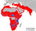
 Cheetah Range
 -
 Leopard
 -
 Puma
Puma -
 Puma, SVG
 -
 Lion
Lion -
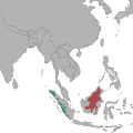
 Bornean Clouded Leopard
 -
 Bornean Clouded Leopard, SVG
 -
 Clouded leopard


Article(s): Cheetah, Leopard, Puma, Lion, Bornean Clouded leopard, Clouded Leopard
Request: Vectorize. I'll give a barnstar to anyone who even can manage to get half done. Connormah ( talk) 05:15, 7 December 2009 (UTC)
Graphist opinion(s):
![]() Request taken by Mononomic. Be back in a bit.
Mononomic (
talk)
01:30, 1 January 2010 (UTC)
Request taken by Mononomic. Be back in a bit.
Mononomic (
talk)
01:30, 1 January 2010 (UTC)
- One is done, File:Neofelis diardi Locator Map.svg. Mononomic ( talk) 02:58, 1 January 2010 (UTC)
- And another, File:Puma concolor Location Map.svg. Whew, this is tiring! Not sure if I'll keep this up, so removing "I take" template so someone else can work on this too. Hope this helps! Mononomic ( talk) 03:57, 1 January 2010 (UTC)

Article(s): ASEAN–China Free Trade Area
Request: Either remove non-ASEAN surrounding countries, or include all per Wiki standards, and remove smaller map as it is not germane to ASEAN... Chris (クリス • フィッチュ) ( talk) 10:03, 2 January 2010 (UTC)
Graphist opinion(s):
-
 according to Mercator perspective

</gallery>
Article(s): several articles could use the map]]
Request: create new version (or fix this one) to clearly show national boundaries in white, so the map is colorable according to Wikipedia standards/or/create new version according to the "Pacific Ocean centered" map at http://english.freemap.jp/world_e/8.html ... Chris (クリス • フィッチュ) ( talk) 10:48, 23 December 2009 (UTC)
Graphist opinion:
Comment: the national boundaries are on there, just not visible at thumbnail size, so it is colorable as is - creating a version with wider white boundaries from this one should be possible. Kmusser ( talk) 18:49, 23 December 2009 (UTC)
- I would name children after you if you could.
Chris (クリス • フィッチュ) (
talk)
22:55, 1 January 2010 (UTC)
- I made an attempt but that file keeps crashing Inkscape, it might be due to the large file size - if someone with a better computer wants to try, it would be appreciated. Kmusser ( talk) 20:47, 7 January 2010 (UTC)
- Thank you for trying, is there a way to reduce the size first?
Chris (クリス • フィッチュ) (
talk)
04:10, 8 January 2010 (UTC)
- Yeah, it could be edited in a text editor, but that's beyond my crude SVG skills. Kmusser ( talk) 04:14, 8 January 2010 (UTC)
Article(s):
List of postcode areas in the United Kingdom
Request: Can someone make a simple black and white svg map of the postal areas in the United Kingdom? There are a couple maps on the net [1] [2] [3] [4]. Brianann MacAmhlaidh ( talk) 11:19, 2 December 2009 (UTC)
- Cool, thanks Classical geographer. The article gets about a 1,000 hits a day [5], and i think it'd really help people out if they can visualise the list there. Another thing was that i was working on a surname article ( McQueen (surname)) and one site [6] lists the frequency of surnames by these postal areas. So if you can come up with an svg version it could be the base for coloured name-distribution maps too.-- Brianann MacAmhlaidh ( talk) 05:57, 3 December 2009 (UTC)
Graphist opinion(s): Actually, there's a map on Commons already, but it's in colour, and PNG. Yet it provides a link to OpenStreetmap, from which an SVG can be extracted as well. I'll give that a try, unless someone else is willing to take it up. Classical geographer ( talk) 18:44, 2 December 2009 (UTC)
- If you can wait four months, Royal Mail sources may become free enough for us to use [7]. Certes ( talk) 17:07, 13 December 2009 (UTC)
- Waiting may be the way to go on this one, the OSM version has definite errors, and versions linked in the request are all copyrighted, if the official map become usable then problem solved.
Kmusser (
talk)
14:45, 14 December 2009 (UTC)
- That makes sense, no harm in waiting and seeing how things unfold,-- Brianann MacAmhlaidh ( talk) 06:42, 20 December 2009 (UTC)
-
 Currently on Commons: colour, PNG

- The Commons map is a good effort but beware of several mistakes. Chelmsford is not on Teesside, nor Motherwell in Fife, and I can see a dozen more subtle errors. London and perhaps NW England need an inset to fit in the missing labels. Certes ( talk) 14:05, 12 January 2010 (UTC)
| This request also appear in Commons as North Africa (orthographic projection). |
-
![[North Africa] orthographic projection](https://upload.wikimedia.org/wikipedia/commons/thumb/8/86/Africa_%28orthographic_projection%29.svg/120px-Africa_%28orthographic_projection%29.svg.png) [North Africa] orthographic projection
[North Africa] orthographic projection -
 Morocco
 -
 Tunisia
 -
 Egypt
Egypt -
 New
New
![[North Africa] orthographic projection](/info/en/?search=File:Africa_(orthographic_projection).svg)
.svg)
.svg)
.svg)
.svg)
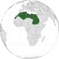
Article(s): North_Africa, Morocco, Algeria, Tunisia, Libya, Egypt
Request: Please create a North Africa centered orthographic projection so I can create/improuve the orthographic projections for the related states. -- Xiquet ( talk) 16:26, 9 January 2010 (UTC)
Graphist opinion: How does this look? Connormah ( talk) 02:13, 15 January 2010 (UTC)


Article(s): multiple over several 'pedias
Request: merge and Wikify stylistically... Chris (クリス • フィッチュ) ( talk) 10:01, 18 January 2010 (UTC)
Graphist opinion(s):

Article(s): Haiti earthquake
Request: Note the epicenter shown here is to the east of the coordinates given by USGS (18.457°N, 72.533°W), this image is probably in error.... Chris (クリス • フィッチュ) ( talk) 11:12, 25 January 2010 (UTC)
Graphist opinion(s):
Resolved Information
-
Chad lake water level 1975-2010
-
 Lake Chad water area and levels 1972 - 2007

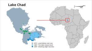
Article(s): Lake Chad
Request: A map of the Chad lake water levels should be made based on the images at http://blogs.nationalgeographic.com/blogs/news/chiefeditor/2010/02/lake-chad-ramsar-convention.html. The map http://commons.wikimedia.org/wiki/File:BlankMap-World-v6.png can be used onto which the lake is drawn; the lake needs to have 2 colors (showing the current level and the wateramount of the lake which has been removed) KVDP ( talk) 11:10, 8 February 2010 (UTC)
Graphist opinion(s):
Quite hard as the latest level 2007 is not much bigger than the 1987 level. Hopefully meets requirements of the request.
If changes are needed, such as removing one of the layers or spacing the text, by all means get in touch :¬)
- Excellent; thanks Chaosdruid. Regarding the world map, I opted for this as it would allow the marking of other lakes,... ie to demonstrate how the reducing water levels of several lakes, ... affect each other. I think however that the map of the entire continent Africa will suffice to allow such use for future images. Regarding the coloring I actually prefered only blue and red (or dark blue, light blue and red), but this will do aswell.
KVDP ( talk) 13:14, 8 March 2010 (UTC)
![]() Request taken by Chaosdruid.
Request taken by Chaosdruid.
![]() Done:
Chaosdruid (
talk)
04:56, 28 February 2010 (UTC)
Done:
Chaosdruid (
talk)
04:56, 28 February 2010 (UTC)

Article(s): Japanese American internment
Request: Trim away extra blank space on right side which skews map... Chris (クリス • フィッチュ) ( talk) 09:43, 1 March 2010 (UTC)
Graphist opinion(s):
![]() Done manually cropped with gimp. --
Erp (
talk)
14:59, 1 March 2010 (UTC)
Done manually cropped with gimp. --
Erp (
talk)
14:59, 1 March 2010 (UTC)
- Great, thank you! -- Chris (クリス • フィッチュ) ( talk) 05:24, 2 March 2010 (UTC)


Article(s):
Request: Make an English-language version, without the border... Chris (クリス • フィッチュ) ( talk) 04:30, 28 February 2010 (UTC)
Graphist opinion(s):
![]() Request taken by Erp. working on this. Put an English version beside above. How does it look?--
Erp (
talk)
06:05, 3 March 2010 (UTC)
Request taken by Erp. working on this. Put an English version beside above. How does it look?--
Erp (
talk)
06:05, 3 March 2010 (UTC)
- Perfect, thank you! -- Chris (クリス • フィッチュ) ( talk) 12:45, 3 March 2010 (UTC)

Article(s):
Request: #2 should be uploaded on top of #1, rather than a new file created for each change-please combine... Chris (クリス • フィッチュ) ( talk) 02:32, 28 February 2010 (UTC)
- Anyway we can get sources for this map or some baseline for "Legal" vs. "Legal, with restrictions". Legal obviously allows for some illegalities (child, animal, etc.) but what is the line? From what I recall Japan has some censorship laws which go beyond the normal "legal"... I think we'd have to justify our cut off between the two? (Not as much for Indian but Australia vs. Japan). gren グレン 18:29, 28 February 2010 (UTC)
Graphist opinion(s):
 Done: Done, both are at
File:Pornography law map.png. I cannot update the hu.wiki to point to the single file because the page is locked. I have marked the duplicates as duplicates on the Commons. -- RA (
talk)
23:07, 3 March 2010 (UTC)
Done: Done, both are at
File:Pornography law map.png. I cannot update the hu.wiki to point to the single file because the page is locked. I have marked the duplicates as duplicates on the Commons. -- RA (
talk)
23:07, 3 March 2010 (UTC)- Thank you, that's all I needed. I don't know about all the issues and all, but it just needed to be reduced to a single file, thanks! -- Chris (クリス • フィッチュ) ( talk) 12:57, 4 March 2010 (UTC)

Article(s):
- Anón
- and 30 others
Request: I need a map of the municipality of Ponce, Puerto Rico showing the boundaries of each of its 31 barrios/ wards. The idea is to create a base map form which we can show (by, say, highlighting in yellow) a specific barrio such as Anón (so on for all 31 barrios).
Background: I have created a category called Barrios of Ponce, http://en.wikipedia.org/wiki/Category:Barrios_of_Ponce, and have written articles for all of them (see, for example, San Patricio and San Antón. However, it would advantageous to have a map that graphically identifies the barrio in each article, which could be added to the article's Infobox,,, something like what this other article for the El Cinco barrio/district/ward of the municipality of San Juan has (and which, in adddition, highlights the barrio/ward in question in color yellow): http://en.wikipedia.org/wiki/El_Cinco,_San_Juan,_Puerto_Rico.
Possible sources for the boundary of the Ponce barrios:
- http://factfinder.census.gov/servlet/GCTTable?_bm=y&-geo_id=05000US72113&-_box_head_nbr=GCT-PH1&-ds_name=DEC_2000_SF1_U&-redoLog=false&-format=CO-2&-mt_name=DEC_2000_SF1_U_GCTPH1_CO2
- http://www.census.gov/geo/www/cob/cs2000.html
- http://www.census.gov/geo/www/cob/cs_metadata.html
- http://www.gis.otg.gobierno.pr/webcensus/
- http://www.trails.com/topo.aspx?panerror=true&z=19&e=759173.152588761&n=1993318.14420084&s=50&size=s&style=drgsr
- http://www.ponceweb.org/Anuncio/Barriosdeponce.pdf
An idea of how the map of the barrios of Ponce might look like when completed:
- http://areciboweb.50megs.com/pr/ponce.html
- http://www.newphoenixservices.com/ponce/images/maps/map-ponce.jpg
(Of course I cannot use either of those two above because they show all the barrios at once, and what I need is 31 "little" (meaning "individual") maps. Also can't use because of copyrights.)
Thanks! Mercy11 ( talk) 02:20, 26 February 2010 (UTC)
Graphist opinion(s):
![]() Request taken by kmusser. at least for the base map, you might then look at template powered solution for highlighting the individual barrios.
Kmusser (
talk)
21:48, 4 March 2010 (UTC)
Request taken by kmusser. at least for the base map, you might then look at template powered solution for highlighting the individual barrios.
Kmusser (
talk)
21:48, 4 March 2010 (UTC)
- Done
Kmusser (
talk)
17:00, 8 March 2010 (UTC)
-
 Tornado watch frequency by county
 -
 Severe thunderstorm watch frequency by county
 -

-


Article(s): Will be used in Tornado watch and Severe thunderstorm watch
Request: Please turn into .svg images...a blank US county map is here if needed. Thanks in advance, Ks0stm ( T• C• G) 02:41, 3 March 2010 (UTC)
Graphist opinion(s):
Would you happen to have the data in tabular form listing counties and frequency? -- Erp ( talk) 05:37, 3 March 2010 (UTC)
- Unfortunately I don't, nor can I find it on the website. I will email the Storm Prediction Center and see if I can get ahold of it or whatever else they used to create the map. Ks0stm ( T• C• G) 15:16, 3 March 2010 (UTC)
If/when this gets completed, obviously it should be a different color scheme. This must be the least intuitive gradient I have ever seen. Calliopejen1 ( talk) 16:42, 3 March 2010 (UTC)
- If you can find the data in tabular form, this script could be used to make a map, similar to what I did here. I think that would be much less time intensive, and more accurate, than copying the existing maps by hand. TastyCakes ( talk) 17:16, 3 March 2010 (UTC)
Says Greg Carbin of the SPC:
| “ | I do have this data in a form that uses county fips codes and the number of times the county has been in a watch. If you can use fips codes to do your plotting, I'd be glad to dig this up and send it along. | ” |
Does FIPS codes work to create the maps? Ks0stm ( T• C• G) 20:08, 7 March 2010 (UTC)
- FIPS codes are unique standard codes for each country (or equivalent such as parish in LA) in the US. A complete list is at http://www.itl.nist.gov/fipspubs/co-codes/states.htm. This should be usable with the script mentioned above (the blank US country map included uses FIPS codes), but, I haven't played with it. Seemingly the data format should be Name (presumably FIPS) column and Data column. However is the data giving averages for 1999-2008 (or equivalent set of years) or does it give counts for each year and the average have to be calculated? -- Erp ( talk) 02:43, 8 March 2010 (UTC)
- Yes, the FIPS codes are what are used in my plotting script. If he could provide the data like that it'd be perfect. The script might have to be modified to change the data column used, but that should be trivial.
TastyCakes (
talk)
17:36, 8 March 2010 (UTC)
- I replied saying that the FIPS code data would work...now it's just a matter of waiting on the data.
Ks0stm (
T•
C•
G)
20:33, 8 March 2010 (UTC)
- Ok...I got the data. TastyCakes, how would you like me to get it to you so you can run it through your script? Ks0stm ( T• C• G) 23:00, 8 March 2010 (UTC)
- I replied saying that the FIPS code data would work...now it's just a matter of waiting on the data.
Ks0stm (
T•
C•
G)
20:33, 8 March 2010 (UTC)
- Yes, the FIPS codes are what are used in my plotting script. If he could provide the data like that it'd be perfect. The script might have to be modified to change the data column used, but that should be trivial.
TastyCakes (
talk)
17:36, 8 March 2010 (UTC)
Great, I have uploaded SVG versions. I haven't put a legend or title on them because I prefer to put those in the thumbnail box with the picture when it's being shown (also makes it easier for people to use on other language Wikipedias), but I can change that if you guys want. TastyCakes ( talk) 16:20, 9 March 2010 (UTC)
- I like the result the way you presented it in the
tornado watch article...very good work. I'll save these files and email them back to the Storm Prediction Center, as Mr. Carbin was interested in seeing the result. Many thanks, TastyCakes.
Ks0stm (
T•
C•
G)
16:47, 9 March 2010 (UTC)
- No problem, it was an interesting diversion... If Mr Carbin wants them in a format other than svg please let me know, it's no problem to export them into PNG or some other format. TastyCakes ( talk) 16:59, 9 March 2010 (UTC)

Article(s): First world
Request: Trim away blank area so displays larger... Chris (クリス • フィッチュ) ( talk) 09:28, 8 March 2010 (UTC)
Graphist opinion(s):
The image is currently up for deletion and should be deleted unless there is a better rationale for why countries are coloured. Several countries would fit in more than one category - just look at the image's talk page. Roke ( talk) 10:23, 13 March 2010 (UTC)
- Understand, you recuse yourself as conflict of interest in this one. Anyone else? --
Chris (クリス • フィッチュ) (
talk)
06:10, 14 March 2010 (UTC)
- A non-COI editor got it at Commons. -- Chris (クリス • フィッチュ) ( talk) 08:12, 14 March 2010 (UTC)
Stale Information
-
Cheetah Range
-
Leopard
-
Puma
-
Puma, SVG
-
Lion
-
Bornean Clouded Leopard
-
Bornean Clouded Leopard, SVG
-
Clouded leopard
Article(s): Cheetah, Leopard, Puma, Lion, Bornean Clouded leopard, Clouded Leopard
Request: Vectorize. I'll give a barnstar to anyone who even can manage to get half done. Connormah ( talk) 05:15, 7 December 2009 (UTC)
Graphist opinion(s):
![]() Request taken by Mononomic. Be back in a bit.
Mononomic (
talk)
01:30, 1 January 2010 (UTC)
Request taken by Mononomic. Be back in a bit.
Mononomic (
talk)
01:30, 1 January 2010 (UTC)
- One is done, File:Neofelis diardi Locator Map.svg. Mononomic ( talk) 02:58, 1 January 2010 (UTC)
- And another, File:Puma concolor Location Map.svg. Whew, this is tiring! Not sure if I'll keep this up, so removing "I take" template so someone else can work on this too. Hope this helps! Mononomic ( talk) 03:57, 1 January 2010 (UTC)
Article(s): ASEAN–China Free Trade Area
Request: Either remove non-ASEAN surrounding countries, or include all per Wiki standards, and remove smaller map as it is not germane to ASEAN... Chris (クリス • フィッチュ) ( talk) 10:03, 2 January 2010 (UTC)
Graphist opinion(s):
-
according to Mercator perspective
</gallery>
Article(s): several articles could use the map]]
Request: create new version (or fix this one) to clearly show national boundaries in white, so the map is colorable according to Wikipedia standards/or/create new version according to the "Pacific Ocean centered" map at http://english.freemap.jp/world_e/8.html ... Chris (クリス • フィッチュ) ( talk) 10:48, 23 December 2009 (UTC)
Graphist opinion:
Comment: the national boundaries are on there, just not visible at thumbnail size, so it is colorable as is - creating a version with wider white boundaries from this one should be possible. Kmusser ( talk) 18:49, 23 December 2009 (UTC)
- I would name children after you if you could.
Chris (クリス • フィッチュ) (
talk)
22:55, 1 January 2010 (UTC)
- I made an attempt but that file keeps crashing Inkscape, it might be due to the large file size - if someone with a better computer wants to try, it would be appreciated. Kmusser ( talk) 20:47, 7 January 2010 (UTC)
- Thank you for trying, is there a way to reduce the size first?
Chris (クリス • フィッチュ) (
talk)
04:10, 8 January 2010 (UTC)
- Yeah, it could be edited in a text editor, but that's beyond my crude SVG skills. Kmusser ( talk) 04:14, 8 January 2010 (UTC)
Article(s):
List of postcode areas in the United Kingdom
Request: Can someone make a simple black and white svg map of the postal areas in the United Kingdom? There are a couple maps on the net [1] [2] [3] [4]. Brianann MacAmhlaidh ( talk) 11:19, 2 December 2009 (UTC)
- Cool, thanks Classical geographer. The article gets about a 1,000 hits a day [5], and i think it'd really help people out if they can visualise the list there. Another thing was that i was working on a surname article ( McQueen (surname)) and one site [6] lists the frequency of surnames by these postal areas. So if you can come up with an svg version it could be the base for coloured name-distribution maps too.-- Brianann MacAmhlaidh ( talk) 05:57, 3 December 2009 (UTC)
Graphist opinion(s): Actually, there's a map on Commons already, but it's in colour, and PNG. Yet it provides a link to OpenStreetmap, from which an SVG can be extracted as well. I'll give that a try, unless someone else is willing to take it up. Classical geographer ( talk) 18:44, 2 December 2009 (UTC)
- If you can wait four months, Royal Mail sources may become free enough for us to use [7]. Certes ( talk) 17:07, 13 December 2009 (UTC)
- Waiting may be the way to go on this one, the OSM version has definite errors, and versions linked in the request are all copyrighted, if the official map become usable then problem solved.
Kmusser (
talk)
14:45, 14 December 2009 (UTC)
- That makes sense, no harm in waiting and seeing how things unfold,-- Brianann MacAmhlaidh ( talk) 06:42, 20 December 2009 (UTC)
-
Currently on Commons: colour, PNG
- The Commons map is a good effort but beware of several mistakes. Chelmsford is not on Teesside, nor Motherwell in Fife, and I can see a dozen more subtle errors. London and perhaps NW England need an inset to fit in the missing labels. Certes ( talk) 14:05, 12 January 2010 (UTC)
| This request also appear in Commons as North Africa (orthographic projection). |
-
[North Africa] orthographic projection
-
Morocco
-
Tunisia
-
Egypt
-
New
Article(s): North_Africa, Morocco, Algeria, Tunisia, Libya, Egypt
Request: Please create a North Africa centered orthographic projection so I can create/improuve the orthographic projections for the related states. -- Xiquet ( talk) 16:26, 9 January 2010 (UTC)
Graphist opinion: How does this look? Connormah ( talk) 02:13, 15 January 2010 (UTC)
Article(s): multiple over several 'pedias
Request: merge and Wikify stylistically... Chris (クリス • フィッチュ) ( talk) 10:01, 18 January 2010 (UTC)
Graphist opinion(s):
Article(s): Haiti earthquake
Request: Note the epicenter shown here is to the east of the coordinates given by USGS (18.457°N, 72.533°W), this image is probably in error.... Chris (クリス • フィッチュ) ( talk) 11:12, 25 January 2010 (UTC)
Graphist opinion(s):
Resolved Information
-
Chad lake water level 1975-2010
-
Lake Chad water area and levels 1972 - 2007
Article(s): Lake Chad
Request: A map of the Chad lake water levels should be made based on the images at http://blogs.nationalgeographic.com/blogs/news/chiefeditor/2010/02/lake-chad-ramsar-convention.html. The map http://commons.wikimedia.org/wiki/File:BlankMap-World-v6.png can be used onto which the lake is drawn; the lake needs to have 2 colors (showing the current level and the wateramount of the lake which has been removed) KVDP ( talk) 11:10, 8 February 2010 (UTC)
Graphist opinion(s):
Quite hard as the latest level 2007 is not much bigger than the 1987 level. Hopefully meets requirements of the request.
If changes are needed, such as removing one of the layers or spacing the text, by all means get in touch :¬)
- Excellent; thanks Chaosdruid. Regarding the world map, I opted for this as it would allow the marking of other lakes,... ie to demonstrate how the reducing water levels of several lakes, ... affect each other. I think however that the map of the entire continent Africa will suffice to allow such use for future images. Regarding the coloring I actually prefered only blue and red (or dark blue, light blue and red), but this will do aswell.
KVDP ( talk) 13:14, 8 March 2010 (UTC)
![]() Request taken by Chaosdruid.
Request taken by Chaosdruid.
![]() Done:
Chaosdruid (
talk)
04:56, 28 February 2010 (UTC)
Done:
Chaosdruid (
talk)
04:56, 28 February 2010 (UTC)
Article(s): Japanese American internment
Request: Trim away extra blank space on right side which skews map... Chris (クリス • フィッチュ) ( talk) 09:43, 1 March 2010 (UTC)
Graphist opinion(s):
![]() Done manually cropped with gimp. --
Erp (
talk)
14:59, 1 March 2010 (UTC)
Done manually cropped with gimp. --
Erp (
talk)
14:59, 1 March 2010 (UTC)
- Great, thank you! -- Chris (クリス • フィッチュ) ( talk) 05:24, 2 March 2010 (UTC)
Article(s):
Request: Make an English-language version, without the border... Chris (クリス • フィッチュ) ( talk) 04:30, 28 February 2010 (UTC)
Graphist opinion(s):
![]() Request taken by Erp. working on this. Put an English version beside above. How does it look?--
Erp (
talk)
06:05, 3 March 2010 (UTC)
Request taken by Erp. working on this. Put an English version beside above. How does it look?--
Erp (
talk)
06:05, 3 March 2010 (UTC)
- Perfect, thank you! -- Chris (クリス • フィッチュ) ( talk) 12:45, 3 March 2010 (UTC)
Article(s):
Request: #2 should be uploaded on top of #1, rather than a new file created for each change-please combine... Chris (クリス • フィッチュ) ( talk) 02:32, 28 February 2010 (UTC)
- Anyway we can get sources for this map or some baseline for "Legal" vs. "Legal, with restrictions". Legal obviously allows for some illegalities (child, animal, etc.) but what is the line? From what I recall Japan has some censorship laws which go beyond the normal "legal"... I think we'd have to justify our cut off between the two? (Not as much for Indian but Australia vs. Japan). gren グレン 18:29, 28 February 2010 (UTC)
Graphist opinion(s):
- Done: Done, both are at
File:Pornography law map.png. I cannot update the hu.wiki to point to the single file because the page is locked. I have marked the duplicates as duplicates on the Commons. -- RA (
talk)
23:07, 3 March 2010 (UTC)
- Thank you, that's all I needed. I don't know about all the issues and all, but it just needed to be reduced to a single file, thanks! -- Chris (クリス • フィッチュ) ( talk) 12:57, 4 March 2010 (UTC)
Article(s):
- Anón
- and 30 others
Request: I need a map of the municipality of Ponce, Puerto Rico showing the boundaries of each of its 31 barrios/ wards. The idea is to create a base map form which we can show (by, say, highlighting in yellow) a specific barrio such as Anón (so on for all 31 barrios).
Background: I have created a category called Barrios of Ponce, http://en.wikipedia.org/wiki/Category:Barrios_of_Ponce, and have written articles for all of them (see, for example, San Patricio and San Antón. However, it would advantageous to have a map that graphically identifies the barrio in each article, which could be added to the article's Infobox,,, something like what this other article for the El Cinco barrio/district/ward of the municipality of San Juan has (and which, in adddition, highlights the barrio/ward in question in color yellow): http://en.wikipedia.org/wiki/El_Cinco,_San_Juan,_Puerto_Rico.
Possible sources for the boundary of the Ponce barrios:
- http://factfinder.census.gov/servlet/GCTTable?_bm=y&-geo_id=05000US72113&-_box_head_nbr=GCT-PH1&-ds_name=DEC_2000_SF1_U&-redoLog=false&-format=CO-2&-mt_name=DEC_2000_SF1_U_GCTPH1_CO2
- http://www.census.gov/geo/www/cob/cs2000.html
- http://www.census.gov/geo/www/cob/cs_metadata.html
- http://www.gis.otg.gobierno.pr/webcensus/
- http://www.trails.com/topo.aspx?panerror=true&z=19&e=759173.152588761&n=1993318.14420084&s=50&size=s&style=drgsr
- http://www.ponceweb.org/Anuncio/Barriosdeponce.pdf
An idea of how the map of the barrios of Ponce might look like when completed:
- http://areciboweb.50megs.com/pr/ponce.html
- http://www.newphoenixservices.com/ponce/images/maps/map-ponce.jpg
(Of course I cannot use either of those two above because they show all the barrios at once, and what I need is 31 "little" (meaning "individual") maps. Also can't use because of copyrights.)
Thanks! Mercy11 ( talk) 02:20, 26 February 2010 (UTC)
Graphist opinion(s):
![]() Request taken by kmusser. at least for the base map, you might then look at template powered solution for highlighting the individual barrios.
Kmusser (
talk)
21:48, 4 March 2010 (UTC)
Request taken by kmusser. at least for the base map, you might then look at template powered solution for highlighting the individual barrios.
Kmusser (
talk)
21:48, 4 March 2010 (UTC)
- Done
Kmusser (
talk)
17:00, 8 March 2010 (UTC)
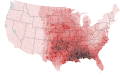
-
Tornado watch frequency by county
-
Severe thunderstorm watch frequency by county
-
-
Article(s): Will be used in Tornado watch and Severe thunderstorm watch
Request: Please turn into .svg images...a blank US county map is here if needed. Thanks in advance, Ks0stm ( T• C• G) 02:41, 3 March 2010 (UTC)
Graphist opinion(s):
Would you happen to have the data in tabular form listing counties and frequency? -- Erp ( talk) 05:37, 3 March 2010 (UTC)
- Unfortunately I don't, nor can I find it on the website. I will email the Storm Prediction Center and see if I can get ahold of it or whatever else they used to create the map. Ks0stm ( T• C• G) 15:16, 3 March 2010 (UTC)
If/when this gets completed, obviously it should be a different color scheme. This must be the least intuitive gradient I have ever seen. Calliopejen1 ( talk) 16:42, 3 March 2010 (UTC)
- If you can find the data in tabular form, this script could be used to make a map, similar to what I did here. I think that would be much less time intensive, and more accurate, than copying the existing maps by hand. TastyCakes ( talk) 17:16, 3 March 2010 (UTC)
Says Greg Carbin of the SPC:
| “ | I do have this data in a form that uses county fips codes and the number of times the county has been in a watch. If you can use fips codes to do your plotting, I'd be glad to dig this up and send it along. | ” |
Does FIPS codes work to create the maps? Ks0stm ( T• C• G) 20:08, 7 March 2010 (UTC)
- FIPS codes are unique standard codes for each country (or equivalent such as parish in LA) in the US. A complete list is at http://www.itl.nist.gov/fipspubs/co-codes/states.htm. This should be usable with the script mentioned above (the blank US country map included uses FIPS codes), but, I haven't played with it. Seemingly the data format should be Name (presumably FIPS) column and Data column. However is the data giving averages for 1999-2008 (or equivalent set of years) or does it give counts for each year and the average have to be calculated? -- Erp ( talk) 02:43, 8 March 2010 (UTC)
- Yes, the FIPS codes are what are used in my plotting script. If he could provide the data like that it'd be perfect. The script might have to be modified to change the data column used, but that should be trivial.
TastyCakes (
talk)
17:36, 8 March 2010 (UTC)
- I replied saying that the FIPS code data would work...now it's just a matter of waiting on the data.
Ks0stm (
T•
C•
G)
20:33, 8 March 2010 (UTC)
- Ok...I got the data. TastyCakes, how would you like me to get it to you so you can run it through your script? Ks0stm ( T• C• G) 23:00, 8 March 2010 (UTC)
- I replied saying that the FIPS code data would work...now it's just a matter of waiting on the data.
Ks0stm (
T•
C•
G)
20:33, 8 March 2010 (UTC)
- Yes, the FIPS codes are what are used in my plotting script. If he could provide the data like that it'd be perfect. The script might have to be modified to change the data column used, but that should be trivial.
TastyCakes (
talk)
17:36, 8 March 2010 (UTC)
Great, I have uploaded SVG versions. I haven't put a legend or title on them because I prefer to put those in the thumbnail box with the picture when it's being shown (also makes it easier for people to use on other language Wikipedias), but I can change that if you guys want. TastyCakes ( talk) 16:20, 9 March 2010 (UTC)
- I like the result the way you presented it in the
tornado watch article...very good work. I'll save these files and email them back to the Storm Prediction Center, as Mr. Carbin was interested in seeing the result. Many thanks, TastyCakes.
Ks0stm (
T•
C•
G)
16:47, 9 March 2010 (UTC)
- No problem, it was an interesting diversion... If Mr Carbin wants them in a format other than svg please let me know, it's no problem to export them into PNG or some other format. TastyCakes ( talk) 16:59, 9 March 2010 (UTC)
Article(s): First world
Request: Trim away blank area so displays larger... Chris (クリス • フィッチュ) ( talk) 09:28, 8 March 2010 (UTC)
Graphist opinion(s):
The image is currently up for deletion and should be deleted unless there is a better rationale for why countries are coloured. Several countries would fit in more than one category - just look at the image's talk page. Roke ( talk) 10:23, 13 March 2010 (UTC)
- Understand, you recuse yourself as conflict of interest in this one. Anyone else? --
Chris (クリス • フィッチュ) (
talk)
06:10, 14 March 2010 (UTC)
- A non-COI editor got it at Commons. -- Chris (クリス • フィッチュ) ( talk) 08:12, 14 March 2010 (UTC)