Westfield, New Jersey | |
|---|---|
 Downtown Westfield | |
 Seal | |
 Map of Westfield in
Union County. Inset: Location of Union County highlighted in the State of
New Jersey. | |
 Census Bureau map of Westfield, New Jersey | |
 Westfield Location in
Union County  Westfield Location in
New Jersey  Westfield Location in the United States | |
| Coordinates: 40°39′06″N 74°20′36″W / 40.651644°N 74.343447°W [1] [2] | |
| Country | |
| State | |
| County | Union |
| Formed | January 27, 1794 |
| Incorporated | February 21, 1798 (as township) |
| Reincorporated | March 4, 1903 (as town) |
| Government | |
| • Type | Special charter |
| • Body | Town Council |
| • Mayor | Shelley Brindle ( D, term ends December 31, 2025) [3] [4] |
| • Administrator | James H. Gildea [5] |
| • Municipal clerk | Maureen Lawshe [6] |
| Area | |
| • Total | 6.74 sq mi (17.46 km2) |
| • Land | 6.72 sq mi (17.42 km2) |
| • Water | 0.02 sq mi (0.05 km2) 0.28% |
| • Rank | 246th of 565 in state 5th of 21 in county [1] |
| Elevation | 118 ft (36 m) |
| Population | |
| • Total | 31,032 |
| • Estimate | 30,559 |
| • Rank | 77th of 565 in state 5th of 21 in county [13] |
| • Density | 4,615.1/sq mi (1,781.9/km2) |
| • Rank | 126th of 565 in state 12th of 21 in county [13] |
| Time zone | UTC−05:00 ( Eastern (EST)) |
| • Summer ( DST) | UTC−04:00 ( Eastern (EDT)) |
| ZIP Codes | 07090–07091
[14] |
| Area code | 908 [15] |
| FIPS code | 3403979040 [1] [16] [17] |
| GNIS feature ID | 0885436 [1] [18] |
| Website |
www |
Westfield is a town in Union County, in the U.S. state of New Jersey, located 16 miles (26 km) southwest of Manhattan. As of the 2020 United States census, the town's population was 31,032, [10] [11] an increase of 716 (+2.4%) from the 2010 census count of 30,316, [19] [20] which in turn reflected an increase of 672 (+2.3%) from the 29,644 counted in the 2000 census. [21]
In March 2018, Bloomberg ranked Westfield as the 99th highest-income place in the United States, and the 18th highest-income location in New Jersey. [22] According to a 2014 nationwide survey, Westfield was ranked as the 30th-safest city to live in the United States. [23]
The town has been one of the state's highest-income communities. Based on data from the American Community Survey for 2013–2017, Westfield residents had a median household income of $159,923, ranked 8th in the state among municipalities with more than 10,000 residents, more than double the statewide median of $76,475. [24]
History

History says that Westfield took its name from the rich "fields west of Elizabeth Town, and hence for over one hundred years went by the name of West Fields." Town records say that "the settlement of Westfield dates back to the last year (1699) of the seventeenth century. It was the result of the 'Clinker Lot Division.' Almost immediately after the division emigration from the older parts of the town of Elizabeth began to set towards the interior,—especially to the territory lying between the Rahway river, on the east, and the mountains, on the west. It was not, however, until 1720 that the settlers became numerous enough to constitute a distinct community." [25] The old village area, now the downtown district, was settled in 1720 as part of the Elizabethtown Tract.

Westfield was originally formed as a township on January 27, 1794, from portions of Elizabeth Township, while the area was still part of Essex County, and was incorporated on February 21, 1798, as one of New Jersey's initial group of 104 townships by an act of the New Jersey Legislature. It became part of the newly formed Union County on March 19, 1857. Portions of the township have been taken to form Rahway Township (February 27, 1804), Plainfield Township (April 5, 1847), Cranford Township (March 14, 1871), Fanwood Township (March 6, 1878; now known as Scotch Plains) and Mountainside (September 25, 1895). The Town of Westfield was incorporated on March 4, 1903, replacing Westfield Township. [26] [27] The name of the town is derived from its location in the western, undeveloped fields of the Elizabethtown tract. [28] [29]
Geography
According to the United States Census Bureau, the town had a total area of 6.74 square miles (17.46 km2), including 6.72 square miles (17.42 km2) of land and 0.02 square miles (0.05 km2) of water (0.28%). [1] [2]
Unincorporated communities, localities and place names located partially or completely within the township include Germantown and Tamaques Reservation Mill. [30]
Six municipalities border the town of Westfield: Mountainside to the north, Springfield Township to the northeast, Garwood and Cranford to the east, Clark to the southeast, and Scotch Plains to the west and southwest. [31] [32] [33]
The upper reaches of the Rahway River Parkway run through the township along tributaries of the Rahway River. [34]
The Robinson's Branch of the Rahway River additionally flows through the southern portion of Westfield en route to the Robinson's Branch Reservoir, also known as the Clark Reservoir.
It is located about one hour from Manhattan.
Community
Library
The Westfield Memorial Library was founded in 1873 as the "Every Saturday Book Club" and has evolved over the past century into the Westfield Memorial Library of today. The Library is located in a large, modern, Williamsburg-style building at 550 East Broad Street. The library's collection consists of over 250,000 books, two dozen public computers, a wide array of multimedia options, a large youth services area with a vivid mural depicting Westfield history, and multiple tables and carrels for studying. The library offers classes for adults and children, storytimes for children, and computer instruction. [35]
Downtown
_just_north_of_New_Jersey_State_Route_28_(North_Avenue)_in_Westfield,_Union_County,_New_Jersey.jpg)
Westfield's downtown features many local and national stores and several landmarks that were shown and used in the NBC network television show Ed such as the Rialto Theater. There are over 40 restaurants and casual dining establishments throughout the downtown. Downtown is located mostly north of the Westfield train station. The downtown area has a mix of independent stores and boutiques as well as national stores. Over one-third of the retailers and restaurants have existed for 25 years or more.
Downtown Westfield, with over 200 retail establishments and 400 commercial enterprises, is a regional destination in New Jersey. The Downtown Westfield Corporation (DWC) manages the Special Improvement District (SID) area's growth and enhancement. The DWC participates in the National Main Street program associated with the National Trust for Historic Preservation. It is funded by a SID assessment on downtown properties and operates as the district's management agency. The DWC sponsors marketing efforts and promotions, special event planning, urban design and building improvement projects. The DWC works closely with the town government and volunteer groups to improve the downtown area. In 2004, Westfield won the Great American Main Street Award from the National Trust. [36] In 2010, Westfield was the winner of the America in Bloom contest for communities with a population of 25,001–50,000 against the other two towns entered in their category. [37] Shopping and dining in Westfield attracts citizens from other communities across the state.
Several war memorials (including ones dedicated to the Korean War, World War II, Spanish–American War, and the Vietnam War) are located in a plaza near the downtown. The plaza is also home to the September 11 Memorial Park, which pays special tribute to the residents of Westfield who died in the September 11 terrorist attacks. [38] [39]
Downtown Westfield hosts events and festivals throughout the year. Throughout the summer, jazz groups perform live, outdoors, every Tuesday night. [40] October 2018 saw the first annual AddamsFest, honoring Westfield resident Charles Addams. The festival featured exhibits, lectures, film screenings, and a masquerade ball, among other things. [41] Other festivals include the Spring Fling and FestiFall. [42]
In August 2020, Le Tote announced that Lord & Taylor, the town's only department store and the chain's only freestanding location in New Jersey, would close as part of a plan to shut down 38 Lord & Taylor store nationwide. Efforts are being made to redevelop the site. [43]
Parks and recreation

Parks in the town include: [44]
- Brightwood Park
- Gumbert Park
- Lenape Park, is a 450-acre (180 ha) wildlife reserve and park that is part of Union County's Rahway River Parkway. The park also includes portions of Cranford, Kenilworth and Springfield Township. [45] An approximately 4.5-mile off-road paved pedestrian path stretches eastbound from Mountainside Police Headquarters in Mountainside, through Echo Lake Park in Westfield, Lenape Park in Westfield and Cranford, Black Brook Park in Kenilworth, and ending near 505 North Michigan Avenue in Kenilworth.
- Mindowaskin Park
- Tamaques Park
- Gary Kehler Stadium is named in honor of Gary Kehler (1931–2007), the former Westfield High School football coach and long-time town resident. [46]
Demographics
| Census | Pop. | Note | %± |
|---|---|---|---|
| 1810 | 2,152 | — | |
| 1820 | 2,358 | 9.6% | |
| 1830 | 2,492 | 5.7% | |
| 1840 | 3,150 | 26.4% | |
| 1850 | 1,577 | * | −49.9% |
| 1860 | 1,719 | 9.0% | |
| 1870 | 2,753 | 60.2% | |
| 1880 | 2,216 | * | −19.5% |
| 1890 | 2,739 | 23.6% | |
| 1900 | 4,328 | * | 58.0% |
| 1910 | 6,420 | 48.3% | |
| 1920 | 9,063 | * | 41.2% |
| 1930 | 15,801 | 74.3% | |
| 1940 | 18,458 | 16.8% | |
| 1950 | 21,243 | 15.1% | |
| 1960 | 31,447 | 48.0% | |
| 1970 | 33,720 | 7.2% | |
| 1980 | 30,447 | −9.7% | |
| 1990 | 28,870 | −5.2% | |
| 2000 | 29,644 | 2.7% | |
| 2010 | 30,316 | 2.3% | |
| 2020 | 31,032 | 2.4% | |
| 2023 (est.) | 30,559 | [10] [12] | −1.5% |
| Population sources: 1810–1920 [47] 1840 [48] 1850–1870 [49] 1850 [50] 1870 [51] 1880–1890 [52] 1890–1910 [53] 1910–1930 [54] 1940–2000 [55] 2000 [56] [57] 2010 [19] [20] [58] 2020 [10] [11] * = Lost territory in previous decade. [26] | |||
2010 census
The 2010 United States census counted 30,316 people, 10,566 households, and 8,199 families in the town. The population density was 4,512.2 per square mile (1,742.2/km2). There were 10,950 housing units at an average density of 1,629.8 per square mile (629.3/km2). The racial makeup was 88.17% (26,729) White, 3.25% (984) Black or African American, 0.12% (36) Native American, 5.67% (1,718) Asian, 0.03% (10) Pacific Islander, 0.79% (241) from other races, and 1.97% (598) from two or more races. Hispanic or Latino of any race were 4.92% (1,492) of the population. [19]
Of the 10,566 households, 43.1% had children under the age of 18; 68.0% were married couples living together; 7.5% had a female householder with no husband present and 22.4% were non-families. Of all households, 19.2% were made up of individuals and 9.8% had someone living alone who was 65 years of age or older. The average household size was 2.85 and the average family size was 3.31. [19]
30.0% of the population were under the age of 18, 4.7% from 18 to 24, 22.5% from 25 to 44, 29.7% from 45 to 64, and 13.1% who were 65 years of age or older. The median age was 41.0 years. For every 100 females, the population had 92.7 males. For every 100 females ages 18 and older there were 87.2 males. [19]
The Census Bureau's 2006–2010 American Community Survey showed that (in 2010 inflation-adjusted dollars) median household income was $127,799 (with a margin of error of +/− $10,580) and the median family income was $150,797 (+/− $11,480). Males had a median income of $111,762 (+/− $7,767) versus $71,217 (+/− $5,624) for females. The per capita income for the town was $63,498 (+/− $4,577). About 0.9% of families and 2.3% of the population were below the poverty line, including 2.4% of those under age 18 and 2.0% of those age 65 or over. [59]
2000 census
As of the 2000 United States census [16] there were 29,644 people, 10,622 households, and 8,178 families residing in the town. The population density was 4,403.1 inhabitants per square mile (1,700.0/km2). There were 10,819 housing units at an average density of 1,607.0 per square mile (620.5/km2). The racial makeup of the town was 89.98% White, 3.88% African American, 0.09% Native American, 4.08% Asian, 0.01% Pacific Islander, 0.62% from other races, and 1.33% from two or more races. Hispanic or Latino of any race were 2.82% of the population. [56] [57]
There were 10,622 households, out of which 40.8% had children under the age of 18 living with them, 68.0% were married couples living together, 7.1% had a female householder with no husband present, and 23.0% were non-families. Of all households, 19.3% were made up of individuals, and 9.4% had someone living alone who was 65 years of age or older. The average household size was 2.77 and the average family size was 3.20. [56] [57]
In the town, the population was spread out, with 28.4% under the age of 18, 4.0% from 18 to 24, 29.6% from 25 to 44, 24.5% from 45 to 64, and 13.5% who were 65 years of age or older. The median age was 39 years. For every 100 females, there were 92.1 males. For every 100 females age 18 and over, there were 87.4 males. [56] [57]
The median income for a household in the town was $98,390, and the median income for a family was $112,145. Males had a median income of $82,420 versus $45,305 for females. The per capita income for the town was $47,187. About 1.7% of families and 2.7% of the population were below the poverty line, including 3.3% of those under age 18 and 3.1% of those age 65 or over. [56] [57]
Government
Local government
Westfield is governed under a special charter granted by an act of the New Jersey Legislature. The town is one of 11 municipalities (of the 564) statewide that operate under special charters. [60] [61] The governing body is comprised of a Mayor and an eight-member Town Council, with all positions filled in partisan elections. The Mayor is elected directly by the voters at-large to a four-year term of office. The Town Council consists of eight members, with two members elected from each of four wards. Town Council members are elected to serve four-year terms on a staggered basis, with one seat in each ward coming up for election every other year. [7] The Town Council holds meetings every two weeks where it discusses legislation under consideration, and which are open to the public.
As of 2024 [update], the Mayor of Westfield is Democrat Michelle W. "Shelley" Brindle, whose term of office ends on December 31, 2025. [62] Members of the Westfield Town Council are Michael Armento (Ward 2; R, 2027), David M. Contract (Ward 3; D, 2025), Michael J. Dardia (Ward 2; D, 2025), Michal D. Domogala (Ward 3; , 2027), Linda S. Habgood (Ward 1; D, 2025), David Kiefer (Ward 4; D, 2027), Dawn Mackey (Ward 4; D, 2025), and Todd B. Saunders (Ward 1; R, 2027). [3] [63] [64] [65] [66]
In April 2022, the Town Council selected Emily Root from a list of three alternatives submitted by the Democratic municipal committee to fill the Ward 1 seat expiring in December 2023 that had been held by James Boyes until he resigned from office earlier that month. Root served on an interim basis until the November 2022 general election, when voters then selected her to serve the balance of the original term of office. [67]
Emergency services
Police
The Westfield Police Department (WPD) has provided police protection to the town since 1903. The chief of police is Christopher Battiloro, who was appointed to the position in December 2018, after serving for four months on an interim basis. [68] The department operates a Patrol Division, Traffic Safety Bureau, Records Bureau, Detective Bureau and its own Emergency Services Unit. Westfield's Parking Services also falls under the jurisdiction of the WPD, and is responsible for monitoring parking and traffic safety within Westfield's Central Business District and near schools. The WPD also has a Law Enforcement Explorers Post, Post #90. [69] Each division of the WPD operates different vehicles, most with a black-and-white paint scheme.
Fire
The Westfield Fire Department was formed in 1875 following a fire that destroyed a city block on East Broad Street. [70] The WFD is a combination department with 36 paid/career firefighters and 15 volunteer firefighters. There are four platoons of eight (a Battalion Chief, two Lieutenants and five Firefighters) working a 24-/72-hour work schedule out of two fire stations. Administrative members include the Chief of Department, the Deputy Chief of Operations, and the Deputy Chief of Fire Prevention. The Fire Safety Inspector position in the Fire Prevention Bureau was eliminated in January 2009 due to budget cuts. The Chief of Department is Anthony Tiller. [71]
Westfield Fire Headquarters, located at 405 North Avenue West, is staffed 24 hours a day by a Battalion Chief (Shift Commander), a lieutenant and three firefighters. These personnel make up the engine company, first due on the north side of town, and the ladder company. A reserve engine company and a utility pick-up are also housed at fire headquarters. The office of the Chief of Department and the Deputy Chief of Operations are located here as well.
Station 2, located at 1029 Central Avenue, is staffed 24 hours a day by a lieutenant and two firefighters. These personnel make up the engine company, first due on the south side of town. A reserve engine company, a utility pick-up, and a spare SUV are also housed at Station 2. The Fire Prevention Bureau is located at Station 2 and houses the office of the Deputy Chief of Fire Prevention.
The WFD in operates a fleet of four E-One Engines (2 x 2,000 GPM & 2 x 1,500 GPM) and 1 Pierce Arrow XT 100' Rearmount Ladder, one support SUV, and three staff 4x4 vehicles. The paint scheme for the older apparatus (Engine 4) is yellow, with the newer apparatus (Ladder 1, Engines 2, 3 & 5) being red bodies with white cabs. The support vehicles, a Ford Pick-Up (Utility 7), a Chevy Pick-Up (Utility 8), and a Jeep Cherokee (Car 9) are red with white striping and the remaining staff vehicles, for Chief Officers, are unmarked Dodge Durangos (Car 1,11,12).
The WFD responds annually to approximately 2,000 calls for service. The WFD serves as a backup EMS agency for the town if the Westfield Volunteer Rescue Squad is not readily available. All members are CPR-Defib certified with 27 members currently New Jersey certified EMTs with the remaining members trained to the first responder level. Both stations are staffed with FF/EMTs 24 hours a day.
The WFD is also a partner in the Union County Fire Mutual Aid agreement, responding to numerous requests for aid to any of the other 20 municipalities in Union County. [72]
The career firefighters (excluding the Chief and Deputy Chiefs) are members of New Jersey Firefighter's Mutual Benevolent Association (NJ FMBA) Local 30. [73]
Rescue squad
The Westfield Volunteer Rescue Squad is staffed around the clock by volunteer certified EMTs. Shifts range from 5 hours in the morning and afternoon to 14 hours overnight. The Squad has three ambulances with a crew every shift. Members are paged in the event that another emergency arises and the original crew is answering a medical call. Dispatchers are also volunteers, answering phones directly from the police line. [74]
Federal, state and county representation
Westfield is located in the 7th Congressional District [75] and is part of New Jersey's 21st state legislative district. [76] [77] [78]
For the 118th United States Congress, New Jersey's 7th congressional district is represented by Thomas Kean Jr. ( R, Westfield). [79] New Jersey is represented in the United States Senate by Democrats Cory Booker ( Newark, term ends 2027) [80] and Bob Menendez ( Englewood Cliffs, term ends 2025). [81] [82]
For the 2024-2025 session, the 21st legislative district of the New Jersey Legislature is represented in the State Senate by Jon Bramnick ( R, Westfield) and in the General Assembly by Michele Matsikoudis (R, New Providence) and Nancy Munoz (R, Summit). [83]
Union County is governed by a Board of County Commissioners, whose nine members are elected at-large to three-year terms of office on a staggered basis with three seats coming up for election each year, with an appointed County Manager overseeing the day-to-day operations of the county. At an annual reorganization meeting held in the beginning of January, the board selects a Chair and Vice Chair from among its members. [84] As of 2024 [update], Union County's County Commissioners are:
Rebecca Williams ( D, Plainfield, 2025), [85] Joesph Bodek (D, Linden, 2026), [86] James E. Baker Jr. (D, Rahway, 2024), [87] Michele Delisfort (D, Union Township, 2026), [88] Sergio Granados (D, Elizabeth, 2025), [89] Bette Jane Kowalski (D, Cranford, 2025), [90] Vice Chair Lourdes M. Leon (D, Elizabeth, 2026), [91] Alexander Mirabella (D, Fanwood, 2024) [92] and Chair Kimberly Palmieri-Mouded (D, Westfield, 2024). [93] [94]
Constitutional officers elected on a countywide basis are: Clerk Joanne Rajoppi (D, Union Township, 2025), [95] [96] Sheriff Peter Corvelli (D, Kenilworth, 2026) [97] [98] and Surrogate Christopher E. Hudak (D, Clark, 2027). [99] [100]
Politics

As of March 2011, there were a total of 20,684 registered voters in Westfield, of which 6,485 (31.4% vs. 41.8% countywide) were registered as Democrats, 5,244 (25.4% vs. 15.3%) were registered as Republicans and 8,942 (43.2% vs. 42.9%) were registered as Unaffiliated. There were 13 voters registered as Libertarians or Greens. [101] Among the town's 2010 Census population, 68.2% (vs. 53.3% in Union County) were registered to vote, including 97.5% of those ages 18 and over (vs. 70.6% countywide). [101] [102]
In the 2012 presidential election, Democrat Barack Obama received 8,080 votes (50.9% vs. 66.0% countywide), ahead of Republican Mitt Romney with 7,555 votes (47.6% vs. 32.3%) and other candidates with 147 votes (0.9% vs. 0.8%), among the 15,866 ballots cast by the town's 21,797 registered voters, for a turnout of 72.8% (vs. 68.8% in Union County). [103] [104] In the 2008 presidential election, Democrat Barack Obama received 9,345 votes (54.5% vs. 63.1% countywide), ahead of Republican John McCain with 7,541 votes (44.0% vs. 35.2%) and other candidates with 154 votes (0.9% vs. 0.9%), among the 17,141 ballots cast by the town's 21,251 registered voters, for a turnout of 80.7% (vs. 74.7% in Union County). [105] In the 2004 presidential election, Democrat John Kerry received 8,442 votes (50.6% vs. 58.3% countywide), ahead of Republican George W. Bush with 8,037 votes (48.2% vs. 40.3%) and other candidates with 110 votes (0.7% vs. 0.7%), among the 16,683 ballots cast by the town's 20,441 registered voters, for a turnout of 81.6% (vs. 72.3% in the whole county). [106]
In the 2013 gubernatorial election, Republican Chris Christie received 64.1% of the vote (6,303 cast), ahead of Democrat Barbara Buono with 34.5% (3,394 votes), and other candidates with 1.3% (131 votes), among the 10,053 ballots cast by the town's 21,513 registered voters (225 ballots were spoiled), for a turnout of 46.7%. [107] [108] In the 2009 gubernatorial election, Republican Chris Christie received 6,070 votes (51.0% vs. 41.7% countywide), ahead of Democrat Jon Corzine with 4,776 votes (40.2% vs. 50.6%), Independent Chris Daggett with 900 votes (7.6% vs. 5.9%) and other candidates with 58 votes (0.5% vs. 0.8%), among the 11,893 ballots cast by the town's 20,982 registered voters, yielding a 56.7% turnout (vs. 46.5% in the county). [109]
Education
Public school students in pre-kindergarten through twelfth grades attend the Westfield Public Schools. [110] As of the 2018–19 school year, the district, comprised of 10 schools, had an enrollment of 6,304 students and 500.4 classroom teachers (on an FTE basis), for a student–teacher ratio of 12.6:1. [111] The district has a central kindergarten, six neighborhood elementary schools (grades 1–5), two middle schools (grades 6–8) divided by a "North Side / South Side" boundary, and one high school (grades 9–12). [112] The schools in the district (with 2018–19 enrollment data from the National Center for Education Statistics [113]) are Lincoln Early Childhood Center [114] (with 310 students; in grades Pre-K–K), Franklin Elementary School [115] (580; 1–5 – North), Jefferson Elementary School [116] (442; 1–5 – South), McKinley Elementary School [117] (341; 1–5 – South), Tamaques Elementary School [118] (401; 1–5 – South), Washington Elementary School [119] (309; 1–5 – North), Wilson Elementary School [120] (355; 1–5 – North), Roosevelt Intermediate School [121] (777; 6–8 – North), Thomas Alva Edison Intermediate School [122] (844; 6–8 – South) and Westfield High School [123] (1,865; 9–12). [124] [125]
For high school, public school students from Westfield and all of Union County are eligible to apply to attend the Union County Vocational Technical Schools, which include Union County Magnet High School, Union County Academy for Information Technology, Union County Academy for Allied Health Sciences, Union County Vocational Technical High School and Union County Academy for Performing Arts. [126]
Holy Trinity School is a Middle States-accredited Catholic school run by the three parishes of Holy Trinity and St. Helen's in Westfield along with Our Lady of Lourdes in Mountainside, which offers education from pre-kindergarten to 8th grade and operates under the auspices of the Roman Catholic Archdiocese of Newark. [127] [128]
Transportation
Roads and highways
_from_the_overpass_for_the_rail_line_between_South_Avenue_and_North_Avenue_in_Westfield,_Union_County,_New_Jersey.jpg)
As of May 2010 [update], the town had a total of 108.63 miles (174.82 km) of roadways, of which 96.69 miles (155.61 km) were maintained by the municipality, 9.94 miles (16.00 km) by Union County and 2.00 miles (3.22 km) by the New Jersey Department of Transportation. [129]
The main road serving Westfield is Route 28, which runs for about two miles alongside the commuter railroad that marks the boundary between the town's North and South Sides. Westfield can also be accessed by Exits 135 and 137 of the nearby Garden State Parkway, or by the Lawrence, Mountain, or Springfield Avenue exits of U.S. Route 22.
Public transportation

NJ Transit (NJT) provides passenger rail service from the Westfield train station. [130] Commuter rail service is offered on the Raritan Valley Line to Newark Penn Station with connecting service to New York Penn Station. [131] Westfield riders are able to make a one-seat ride (no transfer necessary) into NY Penn Station during weekday off-peak hours, which was made possible by upgrades of the NJT train equipment to operate into New York City. Westfield's position and schedule on the Raritan Valley Line make it desirable for commuters, as several times in the morning and evening rush hours a non-stop service operates to/from Newark Penn Station. On these non-stop services, the one-way journey time to/from NY Penn Station is 50 minutes, or 20 minutes to/from Newark Penn Station.
The NJ Transit 113 bus route provides one-seat service to New York City's Port Authority Bus Terminal seven days per week from the town center, taking approximately one hour to NYC, with additional service available along Route 22 on the northern edge of the town (NJT bus routes 114 and 117), taking approximately 45 minutes. The 59 route provides local bus service between Plainfield and Newark. [132]
Newark Liberty International Airport is approximately 20 minutes away, most conveniently reached via Route 22 or NJT trains. Linden Airport, a general aviation facility, is in nearby Linden, New Jersey.
Services
Residential telephone service is provided by Verizon Communications. Westfield cable television is supplied by Comcast [1], which also delivers Westfield Community Television (channel 36), [133] News 12 New Jersey (channel 62), and Scotch Plains Local Access Channel (channel 34) [134] Verizon FiOS is also offered in Westfield, which gives the option of digital cable, high-speed internet and telephone service. Power is supplied through the Public Service Electric and Gas Company. Gas is supplied by Elizabethtown Gas and water by American Water of New Jersey. Recycling is collected curbside by private haulers contracted by the Department of Public Works on a biweekly basis, while trash is collected by private haulers hired by residents.
Media
Westfield is served by the locally published weekly newspaper, The Westfield Leader. [135] The Record-Press had served the community until it ended publication in 2008. Westfield is also served by multi-community newspapers including the Courier News, a daily newspaper based in Bridgewater Township, and The Star-Ledger based in Newark. Westfield Patch is an online news source dedicated strictly to local Westfield news that is updated around the clock by a small staff of paid editors and volunteer contributors. Likewise, TAPInto Westfield is an online news source dedicated to local Westfield news. [136]
Westfield + Cranford Local is a monthly magazine covering the two towns that launched in the early 2020s. [137]
Westfield Community Television (WCT)
The local community access channel 36 operates out of the Municipal Building on Broad Street in Westfield on Mondays, Wednesdays, Fridays and half of every Sunday. WCT provides limited community-related programming, coverage of town council meetings, and operates the WCT Bulletin Board. WCT shares time on channel 36 with Blue Devil Television, which originates from Westfield High School and produces nearly 200 original productions each academic year. [138]
Culture
The Greek Orthodox Archdiocese of America Metropolis of New Jersey is headquartered in Westfield. [139]
Notable people
People who were born in, residents of, or otherwise closely associated with Westfield include:
- Marc Acito (born 1966), playwright, novelist and humorist [140]
- Charles Addams (1912–1988), cartoonist for The New Yorker magazine, most famous for his cartoons of The Addams Family [141]
- Kim Alsop (born c. 1933), former head coach of the Samford Bulldogs football team [142]
- Steve Angeli, American football quarterback for the Notre Dame Fighting Irish. [143]
- Charles E. Apgar (1865–1950), business executive and amateur radio operator best known for making early recordings of German radio transmissions at the start of World War I [144]
- Virginia Apgar (1909–1974), creator of the Apgar score for assessing health of newborns [145]
- Billy Ard (born 1959), former NFL guard for the New York Giants and Green Bay Packers [146]
- H. W. Ambruster (1879–1961), football coach, chemical engineer, actor and lecturer [147]
- Omar Ashmawy, staff director and chief counsel of the Office of Congressional Ethics [148]
- Richard Bagger (born 1960), former mayor, who served as chief of staff for Governor of New Jersey Chris Christie [149] [150]
- Robert L. Barchi (born 1946), twentieth president of Rutgers University, 2012-2020 [151] [152]
- Cheryl Barnes, singer and actress best known for her role in Miloš Forman's 1979 film adaptation of Hair, where she played the mother of Hud's little son [153]
- Carolyn Beebe (1873–1950), pianist who was a founder of the New York Chamber Music Society [154]
- Bryan Beller (born 1971), bass guitarist known for his work with Mike Keneally, Steve Vai, Dethklok, James LaBrie of Dream Theater and Dweezil Zappa [155]
- Jon Bramnick (born 1953), member of the New Jersey General Assembly who has represented the 21st Legislative District since 2003 [150] [156]
- Brock Brower (1931–2014), novelist, magazine journalist and TV writer [157]
- Dave Brown (born 1970), NFL quarterback who played for the New York Giants and Arizona Cardinals [158] [159]
- Steve Brozak (born 1961), Managing Partner and President of WBB Securities, LLC, a Democratic congressional candidate in the 2004 election cycle and the Chairman and CEO of StormBio, Inc. [160]
- Robert N. Buck (1914–2007), aviator and author who broke 14 junior airspeed records in the 1930s, started his flying career at the Westfield Airport [161]
- Alan Bunce (1900–1965), radio and television actor [162]
- Devin Caherly (born 2001, class of 2019), social media personality [163]
- Chris Campbell (born 1954), wrestler who won a bronze medalist in Freestyle wrestling at the 1992 Summer Olympics [164]
- Gil Chapman (born 1953), running back and return specialist for the University of Michigan and New Orleans Saints [165]
- Steve Cheek (born 1977), NFL punter, 2001–2005 ( San Francisco 49ers, Kansas City Chiefs, Carolina Panthers) [166]
- Michael Chertoff (born 1953), United States Secretary of Homeland Security and former United States district court Judge [167] [168]
- John Chironna (1928–2010), head coach of the Rhode Island Rams football team in 1961 and 1962 [169]
- Chris Christie (born 1962), Governor of New Jersey, who lived in Westfield for a year while his home in Mendham was under construction [150]
- Bob Clotworthy (1931–2018), diver who competed in the 3 m springboard at the 1952 and 1956 Olympics and won a bronze and a gold medal, respectively [170]
- Grover Connell (1918–2018), rice trader and longtime member of the Forbes 400 [171]
- Pat Cosquer (born 1975), college squash coach [172]
- John Cuneo (born 1957), illustrator, whose work has appeared in The New Yorker, Esquire, Sports Illustrated and The Atlantic [173]
- Nicholas Delpopolo (born 1989), judoka who has represented the United States at the 2012 Summer Olympics and 2016 Summer Olympics [174]
- Robert S. Dietz (1914–1995), marine geologist, geophysicist and oceanographer who conducted pioneering research concerning seafloor spreading [175]
- Tamecka Dixon (born 1975), former USA national team and WNBA player who played for the Los Angeles Sparks, Houston Comets and Indiana Fever [176] [177]
- Alexander Wilson Drake (1843–1916), artist, collector and critic [178]
- Sara Driver (born 1955), independent filmmaker [179]
- Michael DuHaime (born 1974), Republican strategist and public affairs executive [150] [180]
- Geoff Edwards (1931–2014), actor and game show host [181]
- Edward Einhorn (born 1970), children's author, director and playwright [182]
- Mike Emanuel (born 1967), Washington correspondent for Fox News [183]
- Gail Falkenberg (born 1947), professional tennis player, who may be the oldest tournament tennis player of all time, having competed in ITF Women's World Tennis Tour tournaments as recently as 2021, at age 74 [184]
- Thomas Farley, pediatrician who served as the commissioner of the Philadelphia Department of Health [185]
- Kevin Feige (born 1973), film producer and President of Marvel Studios [186]
- Michael Fennelly (born 1949), rock guitarist, singer and songwriter who performed with The Millennium and Crabby Appleton [187]
- Gerald Foster (1900–1987), painter who competed in the painting event in the art competition at the 1932 Summer Olympics [188]
- William Chapman Foster (1897–1984), businessman and high-ranking government official who negotiated multiple arms control treaties [189]
- Nona Garson (born 1958), equestrian who competed in team jumping and individual jumping at the 2000 Summer Olympics in Sydney [190]
- GH057ayame (gamer tag of Eric Hewitt), retired professional Major League Gaming gamer who works for 343 Industries working on future Halo games [191]
- Gina Glantz (born c. 1943), political strategist, campaign manager, field director and consultant [192] [193]
- John Duval Gluck (1878–1951), philanthropist, customs broker and con artist who is best known for popularizing the practice of sending and answering letters to Santa Claus in New York City [194]
- Dan Graham (born 1942), artist, writer, and curator [195]
- Joseph Greenspan (born 1992), soccer player for the Pittsburgh Riverhounds SC of the United Soccer League [196]
- Robert Greifeld (born 1957), CEO of NASDAQ-OMX [197] [198]
- Matt Gutman (born 1977), ABC News correspondent [199]
- Harry Hanan (1916–1982), cartoonist of the syndicated comic strip Louie [200]
- Kenneth Hand (1899–1988), politician and judge who served in the New Jersey Senate [201]
- Walt Hansgen (1919–1966), race car driver [202]
- Chuck Hardwick (born 1941), politician and business leader who served as Speaker of the New Jersey General Assembly and was a candidate for Governor of New Jersey [203]
- Langston Hughes (1902–1967), poet [204] [205]
- Clark Hulings (1922–2011), realist artist [206]
- Zora Neale Hurston (1891–1960), folklorist [204] [207]
- Scott Jacobs (born 1958), painter known for his photorealistic work of Harley-Davidson motorcycles, who became the company's first official licensed artist in 1993 [208]
- Robert Kaplow (born 1954), teacher and novelist whose coming-of-age novel was made into a film titled Me and Orson Welles [209] [210]
- Thomas Kean Jr. (born 1968), New Jersey State Senator and son of former Governor of New Jersey Thomas Kean [150] [211] [212]
- Mary Jo Keenen, actress who appeared on Nurses [213]
- Kevin Kelly (born 1952), founder of Wired magazine [214]
- Robert Kirsch (born 1966), state court judge from New Jersey who is a nominee to serve as a United States district judge of the United States District Court for the District of New Jersey. [215]
- Martin Kunert (born 1970), film director and TV writer/producer of Voices of Iraq, MTV's Fear and Campfire Tales [216]
- Christian J. Lambertsen (1917–2011), "the father of the Frogmen" [217]
- Marilyn Lange (born 1952), Playboy Playmate for May 1974 and Playmate of the Year for 1975 [218]
- Margaret Carver Leighton (1896–1987), children's author [219]
- Ira Lewis (1932–2015), actor and playwright, whose works included Chinese Coffee [220]
- John List (1925–2008), murderer convicted in the deaths of his wife, mother and three children. Known as the "Boogeyman of Westfield" [221] [222]
- Matt Loughlin, sportscaster who is the radio play-by-play voice of the New Jersey Devils of the National Hockey League on WFAN [223]
- Andrew McCarthy (born 1962), actor who appeared in Weekend at Bernie's and is currently starring in The Family [224]
- Sy Montgomery (born 1958), naturalist, author and scriptwriter [225]
- Patrick Morrisey (born 1967), elected as Attorney General of West Virginia in 2012 [226]
- Rebecca Morse (born 1992), ice hockey defender, currently playing for the Metropolitan Riveters of the National Women's Hockey League [227]
- Laura Overdeck, entrepreneur and philanthropist who is the founder and president of Bedtime Math [228]
- Bill Palatucci (born 1958), attorney who is a member of the Republican National Committee and the New Jersey Apportionment Commission, and led the selection of staff for the presidential transition of Donald Trump [229]
- John S. Penn (1926–2013), politician who represented the 16th Legislative District in the New Jersey General Assembly from 1984 to 1994 [230]
- Randolph Perkins (1871–1936), mayor of Westfield from 1903 to 1905, and represented New Jersey's 6th congressional district from 1921 to 1936 [231] [232]
- Dave Perkowski (born 1947), former competition swimmer who represented the United States in the 100-meter breaststroke event at the 1968 Summer Olympics in Mexico City [233]
- Arthur N. Pierson (1867–1957), businessman and politician who served as Speaker of the New Jersey General Assembly and President of the New Jersey Senate [234]
- Anne Revere (1903-1990), actress who won the Academy Award for Best Supporting Actress for National Velvet and a Tony Award for her performance in Lillian Hellman's play Toys in the Attic in 1960. [235]
- Paul Robeson (1898–1976), athlete, actor, singer, political activist, NFL guard from 1920 to 1922 for the Akron Pros and Milwaukee Badgers [236] [237]
- Andrew K. Ruotolo (1952–1995), politician who served as the Union County, New Jersey, prosecutor [238]
- John Rzeznik (born 1965), lead singer of the Goo Goo Dolls [239] [240]
- Bret Schundler (born 1959), former Mayor of Jersey City and former New Jersey gubernatorial candidate [241] [242]
- Amos Scudder (1779–1856), architect and builder [243]
- Ephraim Scudder (1819–1872), builder [243]
- John Scudder (1815–1869), builder [243]
- Coleen Sexton (born 1979), actress who made her Broadway debut at age 20 in Jekyll & Hyde in 2000 [244]
- Matthew Sklar (born 1973), Tony Award and Emmy Award-nominated composer of Broadway musicals The Prom, Elf the Musical, and The Wedding Singer
- Jessica St. Clair (born 1976), actress and improvisational comedian [245]
- Dan Soucek (born 1969), North Carolina State Senator [246]
- Jeff Torborg (born 1941), MLB player and manager [247] [248]
- P. Roy Vagelos (born 1929), former Chairman and CEO of Merck & Co. [249]
- Jeffrey A. Warsh (born 1960), former member of the New Jersey General Assembly and Executive Director of NJ Transit [250] [251]
- Dave Weinstein (born 1988), appointed by Governor of New Jersey Chris Christie in 2016 to serve as the state's Chief Technology Officer [252]
- Roger Welch (born 1946), conceptual artist [253]
- Harrison A. Williams (1919–2001), U.S. Senator who was forced to resign in the face of expulsion due to his involvement in the Abscam case [254]
- Malinda Williams (born 1975), actress [255]
- Alfred M. Wolin (born 1932), former United States district judge of the United States District Court for the District of New Jersey. [256]
- Glen Everett Woolfenden (1930–2007), ornithologist, known for his long-term study of the Florida scrub jay population at Archbold Biological Station near Lake Placid, Florida [257]
- Harold "Butch" Woolfolk (born 1960), NFL running back from 1982 to 1988 who played for the New York Giants, Houston Oilers and Detroit Lions [258]
- Dan Yemin, punk rock guitarist [259]
Trivia
As recently as 2017, the Broaddus family living in Westfield received letters from a supposed stalker who referred to himself as "The Watcher," causing a national sensation. [260] The Broaddus family's experience, along with the 1971 John List family murders that also occurred in Westfield, were later adapted into the 2022 Netflix series The Watcher. [261]
References
- ^ a b c d e 2019 Census Gazetteer Files: New Jersey Places, United States Census Bureau. Accessed July 1, 2020.
- ^ a b US Gazetteer files: 2010, 2000, and 1990, United States Census Bureau. Accessed September 4, 2014.
- ^ a b Town Council, Town of Westfield. Accessed May 28, 2024.
- ^ 2023 New Jersey Mayors Directory, New Jersey Department of Community Affairs, updated February 8, 2023. Accessed February 10, 2023.
- ^ Administration, Town of Westfield. Accessed March 24, 2023.
- ^ Town Clerk, Town of Westfield. Accessed March 24, 2023.
- ^ a b 2012 New Jersey Legislative District Data Book, Rutgers University Edward J. Bloustein School of Planning and Public Policy, March 2013, p. 94.
- ^ "ArcGIS REST Services Directory". United States Census Bureau. Retrieved October 11, 2022.
- ^ "Town of Westfield". Geographic Names Information System. United States Geological Survey, United States Department of the Interior. Retrieved March 14, 2013.
- ^ a b c d e QuickFacts Westfield town, New Jersey, United States Census Bureau. Accessed December 13, 2022.
- ^ a b c Total Population: Census 2010 - Census 2020 New Jersey Municipalities, New Jersey Department of Labor and Workforce Development. Accessed December 1, 2022.
- ^ a b Annual Estimates of the Resident Population for Minor Civil Divisions in New Jersey: April 1, 2020 to July 1, 2023, United States Census Bureau, released May 2024. Accessed May 16, 2024.
- ^ a b Population Density by County and Municipality: New Jersey, 2020 and 2021, New Jersey Department of Labor and Workforce Development. Accessed March 1, 2023.
- ^ Look Up a ZIP Code for Westfield, NJ, United States Postal Service. Accessed March 3, 2012.
- ^ Area Code Lookup – NPA NXX for Westfield, NJ, Area-Codes.com. Accessed November 1, 2014.
- ^ a b U.S. Census website, United States Census Bureau. Accessed September 4, 2014.
- ^ Geographic Codes Lookup for New Jersey, Missouri Census Data Center. Accessed April 1, 2022.
- ^ US Board on Geographic Names, United States Geological Survey. Accessed September 4, 2014.
- ^ a b c d e DP-1 – Profile of General Population and Housing Characteristics: 2010 for Westfield town, Union County, New Jersey Archived February 12, 2020, at archive.today, United States Census Bureau. Accessed March 3, 2012.
- ^ a b Profile of General Demographic Characteristics: 2010 for Westfield town Archived August 9, 2013, at the Wayback Machine, New Jersey Department of Labor and Workforce Development. Accessed March 3, 2012.
- ^ Table 7. Population for the Counties and Municipalities in New Jersey: 1990, 2000 and 2010, New Jersey Department of Labor and Workforce Development, February 2011. Accessed May 1, 2023.
- ^ Hagan, Shelly; and Lu, Wei. "America’s 100 Richest Places: 2018", Bloomberg News, March 5, 2018. Accessed March 11, 2020.
- ^ Neighborhood Scout's America's Safest Cities 2014, Neighborhood Scout, backed up by the Internet Archive as of November 14, 2014. Accessed November 3, 2019.
- ^ Raychaudhuri, Disha. "The wealthiest towns in N.J., ranked", NJ Advance Media for NJ.com, June 7, 2019. Accessed November 4, 2019. "The median household income in N.J. is $76,475, recent Census data shows.... A note about the data: The data comes from 2013-2017 American Community Survey conducted by U.S. Census Bureau. Smaller towns with less than 10,000 residents were excluded from the list.... 8. Westfield, Union County Median income: $159,923"
- ^ Ricord, Frederick W. (1897). History of Union County New Jersey. Newark NJ: East Jersey History Company. p. 506.
- ^ a b Snyder, John P. The Story of New Jersey's Civil Boundaries: 1606–1968, Bureau of Geology and Topography; Trenton, New Jersey; 1969. p. 242. Accessed May 30, 2024.
- ^ Honeyman, Abraham Van Doren. Index-analysis of the Statutes of New Jersey, 1896-1909: Together with References to All Acts, and Parts of Acts, in the 'General Statutes' and Pamphlet Laws Expressly Repealed: and the Statutory Crimes of New Jersey During the Same Period, p. 313. New Jersey Law Journal Publishing Company, 1910. Accessed October 26, 2015.
- ^ Hutchinson, Viola L. The Origin of New Jersey Place Names, New Jersey Public Library Commission, May 1945. Accessed October 26, 2015.
- ^ Staff. "Westfield Historical Society Historic Marker installed at PNC Plaza", Suburban Trends, October 14, 2015. Accessed October 26, 2015. "The Westfield Historical Society (WHS) historic marker commemorating the settlement of Westfield in 1720 as the West Fields of Elizabethtown has been installed at the PNC Plaza, site of the Old York Road to Philadelphia."
- ^ Locality Search, State of New Jersey. Accessed May 21, 2015.
- ^ Areas touching Westfield, MapIt. Accessed March 11, 2020.
- ^ Union County Municipal Profiles, Union County, New Jersey. Accessed March 11, 2020.
- ^ New Jersey Municipal Boundaries, New Jersey Department of Transportation. Accessed November 15, 2019.
- ^ Our Parks, Friends of Rahway River Parkway. Accessed April 25, 2021.
- ^ History, Westfield Memorial Library. Accessed July 10, 2012.
- ^ Westfield, New Jersey: 2004 Great American Main Street Award Winner, National Trust for Historic Preservation, May 10, 2004. Accessed April 17, 2015.
- ^ Lipstein, Andrew. "Westfield Wins America in Bloom: Town beats Utah and Indiana communities as best town in population category.", WestfieldPatch, October 4, 2010. Accessed July 10, 2012. "The town received top honors Saturday for population category, beating two other communities during the annual America in Bloom contest.... The town beat out Murray City, Utah and Michigan City, Ind. for the top award in the 25,001 to 50,000 population category. For the landscaping award, the town beat all other communities entered in the competition."
- ^ September 11 Memorial Park Committee, Westfield Today. Accessed November 1, 2014.
- ^ Westfield Korean War Memorial, Westfield Today. Accessed November 1, 2014.
- ^ Westfield Today. Accessed January 9, 2019.
- ^ Westfield Patch. Accessed January 9, 2019.
- ^ "FestiFall in Westfield * ~".
- ^ Heapes, Richard. "An Open Letter to the Community of Westfield on Redevelopment", TAP into Westfield, December 16, 2020. Accessed December 27, 2020. "As many of you know, one of those businesses, Lord & Taylor, the entity owned and operated by Le Tote, is permanently closing its doors. It’s a difficult pill to swallow for shoppers that have relied upon and enjoyed the store, and for us, the owners of the property and an active member of the Westfield community for more than 30 years."
- ^ Parks, Town of Westfield. Accessed December 27, 2020.
- ^ Lenape Park, Union County, New Jersey, June 2014. Accessed December 27, 2020.
- ^ Kipp, Matt. "Westfield Re-Dedicates Renovated Gary Kehler Stadium", TAPinto.net, September 21, 2019. Accessed February 14, 2022. "With family members and friends of the stadium’s namesake — legendary Westfield head football coach Gary Kehler — on hand, accompanied by Westfield Board of Education members and town officials, the ribbon was officially cut from the 50-yard line"
- ^ Compendium of censuses 1726–1905: together with the tabulated returns of 1905, New Jersey Department of State, 1906. Accessed May 24, 2013.
- ^ Bowen, Francis. American Almanac and Repository of Useful Knowledge for the Year 1843, p. 231, David H. Williams, 1842. Accessed May 24, 2013. Source lists a population of 3,146 for 1840, in conflict with the 3,150 shown in the New Jersey Compendium of censuses 1726–1905.
- ^ Raum, John O. The History of New Jersey: From Its Earliest Settlement to the Present Time, Volume 1, p. 281, J. E. Potter and company, 1877. Accessed May 24, 2013. "Westfield had a population in 1860 of 1,719 and in 1870, 2,753."
- ^ Debow, James Dunwoody Brownson. The Seventh Census of the United States: 1850, p. 138. R. Armstrong, 1853. Accessed May 24, 2013.
- ^ Staff. A compendium of the ninth census, 1870, p. 261. United States Census Bureau, 1872. Accessed May 24, 2013.
- ^ Porter, Robert Percival. Preliminary Results as Contained in the Eleventh Census Bulletins: Volume III – 51 to 75, p. 99. United States Census Bureau, 1890. Accessed May 24, 2013.
- ^ Thirteenth Census of the United States, 1910: Population by Counties and Minor Civil Divisions, 1910, 1900, 1890, United States Census Bureau, p. 339. Accessed May 24, 2013.
- ^ Fifteenth Census of the United States : 1930 – Population Volume I, United States Census Bureau, p. 719. Accessed May 24, 2013.
- ^ Table 6: New Jersey Resident Population by Municipality: 1940 - 2000, Workforce New Jersey Public Information Network, August 2001. Accessed May 1, 2023.
- ^ a b c d e Census 2000 Profiles of Demographic / Social / Economic / Housing Characteristics for Westfield town, New Jersey Archived August 9, 2013, at the Wayback Machine, United States Census Bureau. Accessed March 1, 2012.
- ^ a b c d e DP-1: Profile of General Demographic Characteristics: 2000 – Census 2000 Summary File 1 (SF 1) 100-Percent Data for Westfield town, Union County, New Jersey Archived February 12, 2020, at archive.today, United States Census Bureau. Accessed December 5, 2012.
- ^ 2010 Census: Union County, Asbury Park Press. Accessed June 16, 2011.
- ^ DP03: Selected Economic Characteristics from the 2006–2010 American Community Survey 5-Year Estimates for Westfield town, Union County, New Jersey Archived February 12, 2020, at archive.today, United States Census Bureau. Accessed March 3, 2012.
- ^ Inventory of Municipal Forms of Government in New Jersey, Rutgers University Center for Government Studies, July 1, 2011. Accessed June 1, 2023.
- ^ "Forms of Municipal Government in New Jersey", p. 15. Rutgers University Center for Government Studies. Accessed June 1, 2023.
- ^ Mayor Shelley Brindle, Town of Westfield. Accessed March 28, 2023.
- ^ Union County Elected Officials, Union County, New Jersey Clerk. Accessed May 28, 2024.
- ^ General Election November 7, 2023 Official Results, Union County, New Jersey, updated November 22, 2023. Accessed January 3, 2024.
- ^ General Election November 8, 2022 Official Results, Union County, New Jersey, updated November 21, 2022. Accessed January 1, 2023.
- ^ General Election November 2, 2021 Official Results, Union County, New Jersey, updated November 15, 2021. Accessed January 3, 2022.
- ^ Wildstein, David. "Root appointed to vacant Westfield council seat Democrat fills vacancy created by resignation of James Boyes", New Jersey Globe, April 27, 2022. Accessed April 30, 2022. "Emily Root has been appointed to fill a vacant seat on the Westfield Township Council. She is replacing James Boyes, who resigned this month to obviate potential conflicts over a pair of redevelopment projects that are near his home. Root was one of three names submitted to the council by the Democratic County Committee.... Boyes was elected in 2019 and Root will need to run in a November 2022 special election to fill the remaining thirteen months of Boyce’s term."
- ^ Kadosh, Matt. "Chris Battiloro is Westfield's New Police Chief, Mayor Says", TAP into Westfield, December 12, 2018. Accessed January 6, 2019. "Mayor Shelley Brindle announced the appointment of Christopher Battiloro to the position of chief on Wednesday. Battiloro has been serving as the department’s acting chief for the past four months, following the abrupt departure of former Chief David Wayman."
- ^ "The Westfield Leader, May 15, 2008, page 4" (PDF).
- ^ History of the Westfield Fire Department, Town of Westfield. Accessed July 23, 2013.
- ^ Westfield Fire Department, Town of Westfield. Accessed April 25, 2021.
- ^ Mutual Aid, Union County, New Jersey. Accessed May 24, 2013.
- ^ Home page, Westfield FMBA Local #30. Accessed May 24, 2013.
- ^ Home Page, Westfield Volunteer Rescue Squad. Accessed July 23, 2013.
- ^ Plan Components Report, New Jersey Redistricting Commission, December 23, 2011. Accessed February 1, 2020.
- ^ Municipalities Sorted by 2011-2020 Legislative District, New Jersey Department of State. Accessed February 1, 2020.
- ^ 2019 New Jersey Citizen's Guide to Government, New Jersey League of Women Voters. Accessed October 30, 2019.
- ^ Districts by Number for 2011–2020, New Jersey Legislature. Accessed January 6, 2013.
- ^ "Congressman Malinowski Fights For The Corporate Transparency Act", Tom Malinowski, press release dated October 23, 2019. Accessed January 19, 2022. "My name, Tom Malinowski. My address, 86 Washington Street, Rocky Hill, NJ 08553."
- ^ U.S. Sen. Cory Booker cruises past Republican challenger Rik Mehta in New Jersey, PhillyVoice. Accessed April 30, 2021. "He now owns a home and lives in Newark's Central Ward community."
- ^ Biography of Bob Menendez, United States Senate, January 26, 2015. "Menendez, who started his political career in Union City, moved in September from Paramus to one of Harrison's new apartment buildings near the town's PATH station.."
- ^ Home, sweet home: Bob Menendez back in Hudson County. nj.com. Accessed April 30, 2021. "Booker, Cory A. - (D - NJ) Class II; Menendez, Robert - (D - NJ) Class I"
- ^ Legislative Roster for District 21, New Jersey Legislature. Accessed January 18, 2024.
- ^ Home Page, Union County, New Jersey. Accessed May 20, 2022.
- ^ Chair Rebecca Williams Archived November 2, 2022, at the Wayback Machine, Union County, New Jersey. Accessed May 20, 2022.
- ^ Vice Chair Christopher Hudak Archived May 28, 2022, at the Wayback Machine, Union County, New Jersey. Accessed May 20, 2022.
- ^ Commissioner James E. Baker Jr., Union County, New Jersey. Accessed May 20, 2022.
- ^ Commissioner Angela R. Garretson, Union County, New Jersey. Accessed May 20, 2022.
- ^ Commissioner Sergio Granados, Union County, New Jersey. Accessed May 20, 2022.
- ^ Commissioner Bette Jane Kowalski, Union County, New Jersey. Accessed May 20, 2022.
- ^ Commissioner Lourdes M. Leon, Union County, New Jersey. Accessed May 20, 2022.
- ^ Commissioner Alexander Mirabella, Union County, New Jersey. Accessed May 20, 2022.
- ^ Commissioner Kimberly Palmieri-Mouded, Union County, New Jersey. Accessed May 20, 2022.
- ^ 2022 County Data Sheet, Union County, New Jersey. Accessed May 20, 2022.
- ^ County Clerk Joanne Rajoppi, Union County Votes. Accessed May 20, 2022.
- ^ Clerks, Constitutional Officers Association of New Jersey. Accessed May 20, 2022.
- ^ Sheriff Peter Corvelli, Union County Sheriff's Office. Accessed May 20, 2022.
- ^ Sheriffs, Constitutional Officers Association of New Jersey. Accessed May 20, 2022.
- ^ Office of the Union County Surrogate, Union County, New Jersey. Accessed May 20, 2022.
- ^ Surrogates, Constitutional Officers Association of New Jersey. Accessed May 20, 2022.
- ^ a b Voter Registration Summary – Union, New Jersey Department of State Division of Elections, March 23, 2011. Accessed May 24, 2013.
- ^ GCT-P7: Selected Age Groups: 2010 – State -- County Subdivision; 2010 Census Summary File 1 for New Jersey Archived February 12, 2020, at archive.today, United States Census Bureau. Accessed May 24, 2013.
- ^ Presidential November 6, 2012 General Election Results – Union County Archived February 1, 2014, at the Wayback Machine, New Jersey Department of State Division of Elections, March 15, 2013. Accessed May 24, 2013.
- ^ Number of Registered Voters and Ballots Cast November 6, 2012 General Election Results – Union County Archived February 1, 2014, at the Wayback Machine, New Jersey Department of State Division of Elections, March 15, 2013. Accessed May 24, 2013.
- ^ 2008 Presidential General Election Results: Union County, New Jersey Department of State Division of Elections, December 23, 2008. Accessed May 24, 2013.
- ^ 2004 Presidential Election: Union County, New Jersey Department of State Division of Elections, December 13, 2004. Accessed May 24, 2013.
- ^ "Governor – Union County" (PDF). New Jersey Department of Elections. January 29, 2014. Retrieved December 24, 2014.
- ^ "Number of Registered Voters and Ballots Cast – November 5, 2013 – General Election Results – Union County" (PDF). New Jersey Department of Elections. January 29, 2014. Retrieved December 24, 2014.
- ^ 2009 Governor: Union County Archived October 17, 2012, at the Wayback Machine, New Jersey Department of State Division of Elections, December 31, 2009. Accessed May 24, 2013.
- ^ Westfield Public Schools District Bylaw 0110 - Identification, Westfield Public Schools. Accessed June 19, 2020. "Purpose: The Board of Education exists for the purpose of providing a thorough and efficient system of free public education in grades kindergarten through twelve in the Westfield School District. Composition: The Westfield School District is comprised of all the area within the municipal boundaries of Westfield."
- ^ District information for Westfield Public School District, National Center for Education Statistics. Accessed April 1, 2020.
- ^ Facts and Figures, Westfield Public Schools. Accessed June 19, 2020.
- ^ School Data for the Westfield Public Schools, National Center for Education Statistics. Accessed April 1, 2020.
- ^ Lincoln School, Westfield Public Schools. Accessed June 19, 2020.
- ^ Franklin Elementary School, Westfield Public Schools. Accessed June 19, 2020.
- ^ Jefferson Elementary School, Westfield Public Schools. Accessed June 19, 2020.
- ^ McKinley Elementary School, Westfield Public Schools. Accessed June 19, 2020.
- ^ Tamaques Elementary School, Westfield Public Schools. Accessed June 19, 2020.
- ^ Washington Elementary School, Westfield Public Schools. Accessed June 19, 2020.
- ^ Wilson Elementary School, Westfield Public Schools. Accessed June 19, 2020.
- ^ Roosevelt Intermediate School, Westfield Public Schools. Accessed June 19, 2020.
- ^ Thomas Alva Edison Intermediate School, Westfield Public Schools. Accessed June 19, 2020.
- ^ Westfield High School, Westfield Public Schools. Accessed June 19, 2020.
- ^ Enrollment Figures, Westfield Public Schools. Accessed June 19, 2020.
- ^ New Jersey School Directory for the Westfield Public Schools, New Jersey Department of Education. Accessed February 1, 2024.
- ^ Full-Time Opportunities, Union County Vocational Technical Schools. Accessed May 24, 2013. "Applicants are selected from a diverse population of eighth grade students in each of the twenty-one municipalities in Union County."
- ^ Union County Catholic Elementary Schools, Roman Catholic Archdiocese of Newark. Accessed March 28, 2023.
- ^ About, Holy Trinity Interparochial School. Accessed March 28, 2023. "The parishes of Saint Helen, Our Lady of Lourdes, and Holy Trinity began cosponsoring the school in 1991. The school site remained at Holy Trinity while the governance was shared by the three pastors. The Mountainside Campus of Holy Trinity Interparochial School opened in September 2002 in an existing building at Our Lady of Lourdes.... Holy Trinity School removed the 'Interparochial' designation in 2017 when the Archdiocese took on more administrative oversight of all its schools and the three co-sponsoring parishes took on more of a spiritual leadership role and less of an administrative one."
- ^ Union County Mileage by Municipality and Jurisdiction, New Jersey Department of Transportation, May 2010. Accessed July 18, 2014.
- ^ Westfield station, NJ Transit. Accessed April 28, 2023.
- ^ Raritan Valley Line schedule, NJ Transit, updated April 23, 2023. Accessed April 28, 2023.
- ^ Union County Bus / Rail Connections, NJ Transit, backed up by the Internet Archive as of July 26, 2010. Accessed March 3, 2012.
- ^ TV36 "Your Town – Your Network", Westfield, New Jersey. Accessed May 24, 2013.
- ^ Home page, Scotch Plains Television. Accessed May 24, 2013. "Cablecast on Comcast cable channel 34, SPTV is available to the citizens of Fanwood and Westfield as well as the residents of Scotch Plains."
- ^ The Westfield Leader (official site)
- ^ Home Page, TAPInto Westfield. Accessed May 22, 2017
- ^ "Westfield + Cranford Local Magazine is your connection to the community". Local Media NJ.
- ^ What is Westfield High School Television?, Westfield, New Jersey. Accessed May 17, 2007.
- ^ Metropolises, Greek Orthodox Archdiocese of America. Accessed February 9, 2014. "215 East Grove Street, Westfield, NJ 07090"
- ^ Chasing Rainbows; The Road to Oz, Goodspeed Musicals. Accessed December 4, 2017. "Marc Acito (Book) was born on January 11, 1966 in Bayonne, New Jersey. Upon graduating from Westfield High School, Acito enrolled in the musical theatre program at Carnegie Mellon, though he left before graduating."
- ^ Maslin, Janet. "In Search of the Dark Muse of a Master of the Macabre: Book Review of Charles Addams: A Cartoonist's Life", The New York Times, October 26, 2006. Accessed March 7, 2008.
- ^ "Jackson Academy hires ex-Samford coach Alsop", The Clarion-Ledger, January 25, 1989. Accessed June 19, 2020. "A native of Westfield, N.J., Alsop received the 1977 Jim Thorpe Award as the outstanding high school coach in Florida."
- ^ Tartaglia, Greg. "North Jersey's Male Athlete of the Week playing 'big boy' football at a high level", The Record, September 9, 2021. Accessed December 19, 2023. "Steve Angeli came north to play high school football and will head to South Bend for college.... That was among the aspects of North Jersey football that drew a Westfield resident to attend a school roughly 30 miles north on the Garden State Parkway."
- ^ "Charles E. Apgar, Radio Expert, 85; Jersey 'Ham' Operator Dies-- Recorded Code Messages From Sayville Station in 1915", The New York Times, August 19, 1950. Accessed June 26, 2022. "Westfield, N.J., Aug. 18-- Charles E. Apgar, a 'ham' radio operator who recorded code messages during World War I from a German station at Sayville, L.I., which proved to be tips to German submarines on the movements of neutral ships and caused the Government to seize the station, died at his home, 549 Carleton Road, after a long illness."
- ^ Dr. Virginia Apgar's test for babies Archived July 23, 2011, at the Wayback Machine, accessed November 30, 2006. Accessed May 24, 2013. "Dr. Virginia Apgar, a Westfield, NJ native, developed the now famous test that measures the infant's physical condition minutes after birth. Her efforts led at least one health official to credit her with doing more to improve the health of mothers, babies and the unborn than perhaps anyone this century."
- ^ Litsky, Frank. "Sports World Specials: Football; Happy Packer", The New York Times, March 12, 1990. Accessed April 23, 2012. "From 1981 through 1988, Ard was a starting guard for the Giants. He was a New Jerseyan through and through. He was raised in Watchung, he lives in Westfield and in the off season he is a stockbroker in Westfield."
- ^ Staff. "Howard Watson Ambruster, Coach, Engineer, Lecturer", Courier News, January 11, 1961. Accessed August 6, 2019. "Fanwood - Howard Watson Ambruster, 82, a retired chemical engineer, lecturer and author, died yesterday (Jan. 10, 1961) in his home at 158 Forest Rd.... Mr. Armbruster resided in Westfield for many years before moving to Fanwood in 1949."
- ^ "Omar Ashmawy", The Washington Post. Accessed December 16, 2017. "Hometown: Westfield, N.J."
- ^ Schleifer, Teddy. "A Tiger in Trenton: Bagger '82", The Daily Princetonian, December 15, 2010. Accessed January 6, 2011.
- ^ a b c d e Waters, Sharon. "The Westfield Five: A course of politics, with a side of laughs", NJBIZ, September 26, 2011. Accessed March 3, 2012. "Only one now-prominent politician seems to have looked at Westfield as a short stay — Christie, who rented in town for about a year while his Mendham house was being built."
- ^ McGlone, Peggy. "Robert Barchi is named Rutgers University president", The Star-Ledger, April 11, 2012. Accessed December 16, 2012. "Born in Philadelphia, Barchi grew up in Westfield, before moving back to Philadelphia during his freshman year of high school, attending St. Joseph's Preparatory School, an elite North Philadelphia institution whose graduates include many high-profile figures in Philadelphia politics."
- ^ "Robert L. Barchi to Serve Final Year as Rutgers University President", Rutgers University, press release dated July 23, 2019. Accessed May 6, 2021.
- ^ Allis, Samuel. "Cheryl Barnes, One Song Later", The Washington Post, May 6, 1979. Accessed October 13, 2021. "Barnes grew up the oldest of five children in a middle class family in the middle class town of Westfield, N.J., 'where everyone is supposed to go to college.'"
- ^ [archives.nypl.org/mus/20263 New York Chamber Music Society scores], New York Public Library. Accessed June 19, 2020. "Carolyn Harding Beebe (she later spelled her first name as Caroline) was born in Westfield, New Jersey, the daughter of Silas Edwin and Helen Tift Beebe, sometime around 1874."
- ^ Wictor, Thomas. "On The Fast Track To Joe's Garage", copy of article from Bass Player, September / October 1995. Accessed October 26, 2015. "Beller was born in Charlottesville, Virginia, but his family moved to Westfield, New Jersey, 'before I could develop a Southern accent.'"
- ^ Walsh, Jeremy. "Westfield council opposes cell tower plan for armory", The Star-Ledger, October 14, 2010. Accessed January 6, 2010.
- ^ Bernstein, Adam. "Brock Brower, magazine journalist, novelist and TV writer, dies at 82", The Washington Post, April 29, 2014. Accessed September 21, 2015. "Brock Hendrickson Brower was born Nov. 27, 1931, in Plainfield, N.J., and raised in Westfield, N.J."
- ^ Anderson, Dave. Sports of The Times; Brown Obeys Phil Simms's Golden Rule, The New York Times, September 5, 1994. Accessed March 3, 2012. "AS a boy growing up in nearby Westfield, N.J., Dave Brown attended only one Giants game at Giants Stadium."
- ^ Pennington, Bill. "Expectations Are High, and Giants' Brown Hopes to Live Up to Them", The New York Times, August 31, 1997. Accessed October 26, 2015. "When Giants General Manager George Young was deciding if Brown was worth a first-round supplemental draft pick five years ago, he liked that Brown was local, from Westfield, N.J., less than 20 miles from Giants Stadium.... Brown, 27, was married in June to Katy Lynch, whom he met and dated at Westfield High School, and they have moved to a house in rural New Jersey."
- ^ Hernandez, Raymond. "Ex-Marine Takes Aim At a Republican", The New York Times, August 8, 2004. Accessed October 26, 2015. "Not long ago, Steve Brozak was a little-known Marine officer who had returned home to Westfield from a tour of duty in Iraq, disillusioned with President Bush's handling of the war there."
- ^ Fox, Margalit. "Robert N. Buck Dies at 93; Was Record-Setting Aviator", The New York Times, May 20, 2007. Accessed August 24, 2018. "Robert Nietzel Buck was born on Jan. 29, 1914, in Elizabethport, N.J., and reared in Westfield, N.J."
- ^ Cox, Jim. The Great Radio Soap Operas, p. 281. McFarland & Company, 1999. ISBN 9781476604145. Accessed October 26, 2015. "Born on June 28, 1908, at Westfield, New Jersey, Bunce appeared in 35 stock productions and on Broadway." Note that this source provides a 1908 birth year, while other sources show 1900 or other dates.
- ^ Siroty, Michael. "A town resident and 2019 Westfield High School graduate has seen a major growth in his social media following recently. Devin Caherly has over 1.3 million followers on TikTok.", TAPinto Westfield, May 29, 2020. Accessed April 25, 2021. "A town resident and 2019 Westfield High School graduate has seen a major growth in his social media following recently. Devin Caherly has over 1.3 million followers on TikTok."
- ^ Thomsen, Ianvia International Herald Tribune. "Boardroom Lawyer Tries His Toughest Case - on the Mat", The New York Times, July 30, 1992. Accessed June 19, 2020. "As a boy, Campbell would go door to door in his hometown of Westfield, New Jersey, making speeches, encouraging participation in the religion."
- ^ 2008 Hall of Fame Inductees: Gil Chapman Archived September 15, 2010, at the Wayback Machine, Elizabeth, New Jersey. Accessed January 6, 2011.
- ^ Chiefs Sign P Steve Cheek Archived September 30, 2007, at the Wayback Machine, Kansas City Chiefs press release dated October 13, 2004. Accessed March 6, 2008.
- ^ PoliticsNJ.com Inside the Beltway, accessed April 17, 2015. "...Michael Chertoff of Westfield was appointed U.S. Secretary of Homeland Security..."
- ^ Corbin, Horace. "A Night With Michael Chertoff", The Westfield Leader, March 31, 2010. Accessed October 26, 2015. "Born in Elizabeth, N.J. and a former Westfield resident, Michael Chertoff returned to his Jersey roots last Wednesday night for dinner at Echo Lake Country Club, sponsored by Asm. Jon Bramnick."
- ^ Westfield Hall of Fame Members, Westfield Today. Accessed October 26, 2015. "John Chironna—All-State Football Group 3."
- ^ Wigo, Bruce. "Olympic Diving Champion Bob Clotworthy Passes Away at 87", Swimming World, June 11, 2018. "Olympic diving champion Robert (Bob) Lynn Clotworthy passed away peacefully at his home, in Salt Lake City, Utah on June 1st. He was 87 years old. Born in Westfield, New Jersey, Bob attended the Ohio State University where he won 11 Big Ten, NCAA, and National AAU Championships before capping off his career with an Olympic gold medal at Melbourne in 1956."
- ^ "For Westfield Biz Magnate, Neighbors Were 'Extremely Important'". TAPinto. Retrieved March 27, 2022.
- ^ Staff. "Campus Notes" Archived April 7, 2014, at the Wayback Machine, Westfield Record, November 23, 1995. Accessed July 7, 2013. "Patrick L. Cosquer of Westfield is serving this year as a junior adviser at Bates College.... A member of the men's squash and baseball teams, Mr. Cosquer is a 1993 graduate of Westfield Senior High School."
- ^ "Interview with John Cuneo", Illoz. Accessed September 2, 2020. "[Q:] There's a pretty reliable rumor going around that you grew up in Westfield, New Jersey. What schools did you attend, from elementary through high school? [A:] I don't remember the name of the Westfield Elementary school I went to. I attended Roosevelt Jr. High and then Westfield High School in NJ through my jumior year."
- ^ D'Allesandro, Dave. "Olympics 2012: Nick Delpopolo, of Westfield, attempting to win gold in judo and make most of special opportunity", The Star-Ledger, July 28, 2012. Accessed August 8, 2016.
- ^ Sullivan, Walter. "Robert Dietz, Who Demonstrated Drift of Ocean Floors, Dies at 80", The New York Times, May 24, 1985. Accessed November 17, 2020. "Robert Sinclair Dietz was born in Westfield, N.J."
- ^ Kadosh, Matt. "WNBA Legend Tamecka Dixon Delivers Keynote at Westfield High School Graduation", TAP into Westfield, June 24, 2022. Accessed March 23, 2023. "Retired WNBA star Tamecka Dixon’s wisdom for Westfield High School’s class of 2022: don’t expect quick success. The Westfield native and former guard for the Los Angeles Sparks in delivering the keynote address at commencement Thursday sought to prepare the 453 graduates for their years to follow."
- ^ Alkaly, Ben. "Where Are They Now: Tamecka Dixon", WNBA. Accessed March 27, 2023. "Dixon said from her current home in Westfield, N.J. 'Growing up, I knew of a few women who had played oversees, but I was just elated to have an opportunity to play in my own country in front of family and friends.'"
- ^ Staff. "Alexander Wilson Frake", American Art News, Vol. 14, No. 19 (February 12, 1916), p. 4. Accessed October 26, 2015. "The 'father of new wood engraving,' which attracted so much attention abroad as well as at home, was born at Westfield, N. J."
- ^ Maurer, Mark. "Jersey Girl Turned Director Sara Driver Is Reunited With Her Long-lost First Film", The Star-Ledger, October 26, 2011, updated March 30, 2019. Accessed January 31, 2022. "Driver, who grew up in Westfield, filmed You Are Not I -- based on a short story by Bowles -- not far from her parents' home."
- ^ Staff. "Profile: Michael DuHaime", The Record, September 3, 2014. Accessed October 26, 2015. "Hometown: Westfield"
- ^ Staff. "Geoff Edwards: He knows all the ropes of hosting", Beaver County Times, March 19, 1977. Accessed January 6, 2011.
- ^ Staff. "Former Westfielder Publishes First Novel, Paradox in Oz", The Westfield Leader, February 3, 2000. Accessed September 17, 2011. "Edward Einhorn, who grew up in Westfield, has recently published his first novel Paradox in Oz."
- ^ Staff. "Fox News White House Correspondent Mike Emanuel to Speak at Stockton Scholarship Luncheon", Stockton University, October 25, 2010. Accessed December 17, 2011. "Greek-American Mike Emanuel grew up in Westfield, New Jersey and attended Holy Trinity Greek Orthodox Church."
- ^ "At 41, Woman Chases Dreams of Professional Tennis Circuit", St. Louis Post-Dispatch, July 24, 1988. Accessed January 31, 2022, via Newspapers.com. "Gail Falkenberg, a former producer-director from Hollywood, might have the makings of a blockbuster hit for the 1990s.... Falkenberg was an only child growing up in Westfield, N.J. Her parents divorced when she was 8."
- ^ Hartocollis, Anemona. "Running for Your Life", The New York Times, November 5, 2010. "It was still dark when Dr. Thomas A. Farley got to Central Park on a cool October morning and started stretching his grasshopperlike legs, blending into the background in black shorts and a T-shirt.... Dr. Farley grew up in Westfield, N.J., the sixth of eight children."
- ^ Barnes, Brooks. "With Fan at the Helm, Marvel Safely Steers Its Heroes to the Screen", The New York Times, July 24, 2011. Accessed May 24, 2013. "Mr. Feige, who is married to a cardiothoracic nurse and has a 2-year-old daughter, grew up in Westfield, N.J."
- ^ "The Rock Town Hall Interview: Mystery Date Michael Fennelly of Crabby Appleton and The Millennium", Rock Town Hall, November 27, 2010. Accessed August 9, 2020. "Fennelly grew up in Westfield, New Jersey, which he left at the age of 17, hitchhiking his way to California with visions of a career in music."
- ^ Gerald Sargent Foster, Smithsonian American Art Museum. Accessed August 9, 2020. "Born Westfield, New Jersey"
- ^ "William C. Foster, Former Arms Control Aide", The New York Times, October 16, 1984. Accessed July 14, 2019. "Born in Westfield, N.J., he attended the Massachusetts Institute of Technology."
- ^ Nona Garson, Sports-Reference.com. Accessed July 30, 2019. "Born: September 30, 1958 (Age 60.303, YY.DDD) in Westfield, New Jersey, United States"
- ^ Kane, Michael. "Dream Job", New York Post, August 25, 2008. Accessed May 6, 2021. "A Penn State student and Westfield, NJ, resident, Hewitt competes on a four-member 'Halo 3' team at a half-dozen MLG gaming festivals each year, where he and his teammates take the stage to wage virtual warfare for tournament prize money that reaches $20,000 per event."
- ^ Dao, James. "Homecoming; The Bill Bradley Campaign as a Celebration and Affirmation of the Garden State", The New York Times, October 24, 1999. Accessed October 18, 2015. "Gina Glantz, 56, the campaign manager, was raised in Westfield and later moved to Ridgewood, where she raised her two children."
- ^ Gordon, Meryl. "Bradley's Other Woman", New York. Accessed October 26, 2015. "With Bradley and his wife, Ernestine, in the van just ahead, Glantz, a 56-year-old Westfield, New Jersey, native, is already plotting the next move in her man's insurgent campaign: the March 7 showdown with Gore in New York, a do-or-die date for Bradley, who considers the state virtually his home turf."
- ^ Palmer, Alex. "Meet the con artist who popularized writing to Santa Claus", New York Post, September 20, 2015. Accessed June 19, 2020. "Then, in 1913, just as the Post Office was about to give up, a man named John Duval Gluck stepped forward. He’d be Santa Claus.... The oldest of five brothers, Gluck had lived for two years in Bedford-Stuyvesant, Brooklyn, before his family moved to Westfield, NJ."
- ^ Dan Graham Biography Archived April 3, 2016, at the Wayback Machine, MetroArtWork. Accessed March 14, 2014. "He was born in Urbana, Illinois, but moved to Winfield Park, New Jersey at age 3, and then to Westfield, NJ at age 13."
- ^ Joseph Greenspan, Navy Midshipmen men's soccer. Accessed November 2, 2018. "Hometown Westfield, N.J. High School Westfield... Greenspan lettered three times in soccer at Westfield High School, before graduating in 2011."
- ^ Staff. "NASDAQ CEO: Robert Greifeld", China Radio International, December 15, 2005. Accessed March 5, 2011. "Greifeld is a resident of Westfield, New Jersey where he resides with his wife and three children."
- ^ Ali, Sam. "Market man; Greifield quickly makes big changes at the NASDAQ", The Star-Ledger, June 27, 2004. Accessed October 26, 2015. "Yet, in his backyard in Westfield, Greifeld has built a makeshift bog that is home to 10 turtles and a tortoise."
- ^ Wilson, Dennis. "Matt Gutman to Be Honored by National Football Group", Scotch Plains-Fanwood Times, March 21, 1996. Accessed September 9, 2017. "Westfield's Matt Gutman will be honored by the Essex County Chapter of the National Football Foundation and Hall of Fame at the annual Scholar-Athlete Awards Banquet to be held at Mayfair Farms in West Orange."
- ^ "Two Veteran Cartoonists Dead", The Comics Journal, April 1982. Accessed June 27, 2017. "Harry Hanan, the creator of the comic strip Louie, died January 19, 1982 at the age of 65. ... At the time of his death, Hanan was living in Westfield, New Jersey; he is survived by his wife, a daughter, and two sons."
- ^ Manual of the Legislature of New Jersey, p. 285. Accessed June 19, 2020. "Kenneth C. Hand, Westfield - Kenneth C. Hand, born on May 6, 1809, is a graduate of Rutgers and Columbia Law School."
- ^ Staff. "Walt Hansgen", Sports Illustrated, January 20, 1958. Accessed December 4, 2017. "To Walter Edwin Hansgen, 38, of Westfield, N.J. goes Sports Illustrated's award as U.S. Sports Car Driver of 1957."
- ^ Hardwick, Chuck. "New Jersey Opinion; The Dangers Of Divestiture", The New York Times, June 23, 1985. Accessed October 26, 2015. "Chuck Hardwick of Westfield represents the 21st District (part of Union County) in the State Assembly, of which he is the Republican leader."
- ^ a b Mule Bone: Langston Hughes and Zora Neale Hurston's Dream Deferred of an African-American Theatre of the Black Word., African American Review, March 22, 2001. Accessed March 7, 2008. "In February 1930, Hurston headed north, settling in Westfield, New Jersey. Godmother Mason (Mrs. Rufus Osgood Mason, their white protector) had selected Westfield, safely removed from the distractions of New York City, as a suitable place for both Hurston and Hughes to work."
- ^ Staff. "Author To Leave Japan.; J.L. Hughes Will Depart After Questioning as to Communism.", The New York Times, July 25, 1933. Accessed August 24, 2018. "James Langston Hughes won the $400 Harmon Foundation prize for literature in 1931. His home is in Westfield, N. J.".
- ^ Sharpe, Tom. "Santa Fe artist Clark Hulings dies at 88", The Santa Fe New Mexican, February 5, 2011. Accessed March 5, 2011. "In 1928, the family settled in Westfield, N.J., where Hulings' skills as a painter were first recognized."
- ^ Horner, Shirley. "About Books", The New York Times, February 16, 1986. Accessed March 3, 2012. "Dr. Lewis said that his research 'points out that, thanks to Mrs. Mason's generosity, Hughes lived in the early 1930s in a one-family house in Westfield, where his neighbor was another of Harlem's luminaries, Zora Neale Hurston.'"
- ^ Daly, Sean. "He fled abuse in New Jersey, made fortune. Now he’s back", New York Post, May 29, 2012. Accessed February 25, 2022. "Coming home to New Jersey brought back painful memories for ABC’s newest Secret Millionaire, Scott Jacobs. The famous commercial artist — whose paintings sell for up to $145,000 each — grew up in suburban Westfield, but fled to southern California in 1996."
- ^ "Hipp celebration spotlights excellence" Archived January 12, 2016, at the Wayback Machine, New Jersey Education Association, December 1, 2014. Accessed October 26, 2015. "This year's honorees were former NJEA President Barbara Keshishian, a 1968 graduate of North Bergen High School; author and educator Robert Kaplow, a 1972 graduate of Westfield High School; and jazz guitarist Julio Fernandez, a 1972 graduate of Hoboken High School."
- ^ Keill, Liz. "After 'going Hollywood,' Kaplow is back at Summit High School", Independent Press, December 15, 2009. Accessed October 26, 2015. "Kaplow's novel is sprinkled with references to Westfield, as Efron's character takes the train back and forth to Manhattan. 'I was raised in Westfield and attended Westfield High School,' Kaplow said."
- ^ Chen, David W. "For Menendez and Kean, a Fierce First Debate", The New York Times, June 26, 2006. Accessed March 7, 2008. "Then, a few minutes later, the most dramatic exchange occurred when Mr. Kean sought to contrast his own background and record in Westfield, a wealthy suburb, with Mr. Menendez's in Hudson County."
- ^ Kean prepares to launch '06 U.S. Senate bid Archived December 13, 2006, at the Wayback Machine, PoliticsNJ.com, March 9, 2005.
- ^ "Celebrity Q & A", Albuquerque Journal, February 26, 1993. Accessed June 19, 2020, via Newspapers.com. "Question: I'd like to know about Mary J. Kennen, Julie on Nurses.... Answer: Keenen is a native of Westfield, N.J., studied theater at Marymount Manhattan College in New York City and made her professional acting debut in the soap Search for Tomorrow."
- ^ Kevin Kelly -- Chronology Archived April 23, 2007, at the Wayback Machine. Accessed March 8, 2008. "Graduated from Westfield High School, Westfield NJ."
- ^ Questionnaire for Judicial Nominees: Robert Andrew Kirsch, United States Senate Committee on the Judiciary. Accessed January 25, 2023. "Residence: Westfield, New Jersey 4. Birthplace: State year and place of birth. 1966; Livingston, New Jersey"
- ^ Biography, MartinKunert.com. Accessed January 31, 2022. "Martin was born in Warsaw, Poland in 1974, spent a year in London, lived in Westfield, New Jersey. He entered pre-med at New York University, then horrified his family by switching to the film school. They still have not forgiven him."
- ^ Hevesi, Dennis. "Christian Lambertsen, Inventor of Scuba Precursor, Dies at 93", The New York Times, February 25, 2011. Accessed March 5, 2011. "Christian James Lambertsen was born in Westfield, N.J., on May 17, 1917, one of four children of Chris and Ellen Lambertsen."
- ^ Marilyn Lange Archived February 28, 2012, at the Wayback Machine, Playboy. Accessed November 18, 2007.
- ^ Guide to the Margaret Carver Leighton Papers, Washington State University. Accessed November 21, 2007.
- ^ Slotnik, Daniel E. "Ira Lewis, Actor and Playwright, Dies at 82", The New York Times, April 16, 2015. Accessed May 18, 2015. "Mr. Lewis, who lived in Westfield, N.J., is survived by two brothers, Marvin and Seymour."
- ^ Hepp, Rick. "Westfield's notorious killer John List is dead", The Star-Ledger, March 24, 2008. Accessed March 5, 2011. "The List family home at 431 Hillside Avenue in Westfield, before it was burned in a suspicious fire in 1972."
- ^ Massacre Archived July 11, 2005, at the Wayback Machine, Court TV Crime Library, accessed December 30, 2006.
- ^ Tufaro, Greg; McGurk, Tom; Falk, Steven; Havsy, Jane; Newman, Josh; Stapleton, Art. From the field to the booth: These New Jersey athletes became sports broadcasters", The Record, October 18, 2019. Accessed October 20, 2019. "Matt Loughlin... The longtime Westfield resident is the radio play-by-play voice of the New Jersey Devils after previously working as a pre- and post-game host on the TV side."
- ^ "Kidsday Celebrity Spotlight Andrew McCarthy", Newsday, July 31, 1988. "With his successes in 'St. Elmo's Fire,' 'Pretty in Pink' and last year's hit, 'Mannequin,' handsome 25-year-old Andrew McCarthy is well on his way to becoming a major star. He was born in Westfield, N.J., on Nov. 29, 1962."
- ^ "Grown-up Book Club", The Reading Bug. Accessed January 4, 2021. "Sy was born in 1958 in Frankfurt German. She graduated from Westfield High School in Westfield, New Jersey and from Syracuse University, a triple major with dual degrees in magazine journalism from the S.I. Newhouse School of Public Communications and in French language and literature and psychology from the College of Arts and Sciences."
- ^ Peyton, Paul J.; Stalker, Suzette; and Johnson, Brian. "Ferguson Tops Kean to Win GOP Congressional Primary", The Westfield Leader, June 8, 2000. Accessed December 5, 2012. "Assemblyman Joel Weingarten of Millburn (R-21st), at 5,862 votes, or 22.8 percent of the vote, took third place, followed by Patrick Morrisey of Westfield, a former House Commerce Committee counsel, who garnered 2,214 tallies, or 8.6 percent of the vote."
- ^ Kadosh, Matt. "", TAP into Westfield, January 17, 2019. Accessed January 4, 2021. "Westfield, NJ – There weren’t many opportunities available for girls to play hockey when she grew up in the town, but that didn’t stop her. Rebecca Morse, who plays for the Metropolitan Riveters, a part of the National Women’s Hockey League, is pleased to see that the sport has become more accessible in her hometown, particularly for girls."
- ^ "Westfield native confronts math phobia by making math an adventure", Suburban News, February 27, 2014, updated March 29, 2019. Accessed June 19, 2020. "Laura Overdeck is many things – a mom of three, astrophysicist, MBA, and philanthropist, but her real passion is taking the fear and boredom out of learning math. She founded the national nonprofit Bedtime Math to help families discover the math in their everyday lives."
- ^ Waters, Sharon Ann. "The Westfield Five: A course of politics, with a side of laughs", NJBiz, September 26, 2011. Accessed August 1, 2016. "Bill Palatucci - Background: In Westfield 30 years."
- ^ "Obituary: John Stanton Penn", Courier News, November 3, 2013. Accessed December 13, 2022. "John 'Jack' Stanton Penn, of Bedminster, NJ passed away on Friday, November 1, 2013 in Lyons Veterans Hospital, Basking Ridge, NJ.... He grew up in Westfield and attended Columbia University."
- ^ Randolph Perkins, Biographical Directory of the United States Congress. Accessed July 8, 2007.
- ^ Staff. "Randolph Perkins, Legislator, Dead; Jersey Member of Congress Had Served Since 1920; Recently Renominated. Long Active In Politics Also Prominent as a Lawyer, Had Been an Assemblyman and Mayor of Westfield.", The New York Times, May 26, 1936. Accessed March 5, 2011.
- ^ "Spitz Shatters Butterfly Mark; U.S. Swimmer Sets Second World Record in 2 Days", The New York Times, October 9, 1967. Accessed January 18, 2021. "Klaus Barth scored the only German victory today taking the 200-meter breaststroke in 2:31:03, a West German record. Dave Perkowski of Westfield, N. J., was second in 2:33:19."
- ^ "Arthur Pierson, Ex-Legislator, 89; Former Jersey State Senator and Assemblyman Dies-- an Expert on Finance", The New York Times, March 9, 1957. Accessed June 19, 2020. "Westfield, N.J., March 8 --Arthur N. Pierson of 237 Kimball Avenue, a former State Senator, Assemblyman and Union County treasurer, died tonight at Muhlenberg Hospital, Plainfield, after an illness of several weeks."
- ^ "Miss Anne Revere, Westfield, Works In Picture of Her Stage Success", Courier News, March 5, 1934. Accessed March 5, 2024, via Newspapers.com. "Miss Revere is a graduate nf Westfield High School and of Wellesley College, and has had a most interesting career."
- ^ Nottle, Diane. "Jerseyana; Remembering Paul Robeson, in His Jersey Days and Beyond", The New York Times, March 29, 1998. Accessed March 3, 2012. "When he was 8, his family moved to Westfield, where he attended school with white children (mainly because there weren't enough black children in town to segregate them)."
- ^ Legacy Recordings – Paul Robeson, accessed April 24, 2007. "Three years later, the Robeson family moved to Westfield, New Jersey."
- ^ Staff. "Andrew Ruotolo, 42, A County Prosecutor", The New York Times, September 22, 1995. Accessed December 31, 2017. "Andrew K. Ruotolo Jr., who as Union County Prosecutor in New Jersey created a special task force to wage war against car theft in Newark, died on Thursday at his home in Westfield, N.J. He was 42."
- ^ Lustig, Jay. "Rzeznik talks about living in NJ, Springsteen and more in ‘Financially Speaking’ podcast", NJArts.net, December 2, 2020. Accessed September 5, 2021. "John Rzeznik will always be associated with the city of Buffalo, where he grew up and where his band The Goo Goo Dolls started out in the ’80s. But he has been living in Westfield for the past five years or so, and is very happy about it."
- ^ O'Shei, Tim. "John Rzeznik unveiled: Goo Goo Dolls frontman finds peace in sobriety, love in fatherhood", The Buffalo News, October 12, 2018. Accessed March 22, 2023. "Westfield, N.J. – John Rzeznik lives in a spacious, two-story home with manicured landscaping and a wrap-around porch supported by white columns."
- ^ Staff. "Biography of former Education Commissioner Bret Schundler", The Star-Ledger, August 27, 2010. Accessed March 5, 2011. "Born: Morristown, grew up in Woodbridge and Westfield. Hometown: Jersey City. Education: Graduated Westfield High School in 1977."
- ^ Bret's Bio, accessed April 24, 2007. "As the youngest of nine-children growing up in Woodbridge and Westfield, NJ, Bret learned the importance of hard-work and honesty."
- ^ a b c Amos Scudder: A Yankee in Savannah, Shelley Carroll, Armstrong State College (1994)
- ^ Filichia, Peter. "Westfield's Coleen Sexton follows 'Legally Blonde' tour home", The Star-Ledger, May 28, 2010. Accessed September 17, 2011. "'I'm Brooke Windham, an exercise guru,' says Sexton, a Westfield native. 'Unfortunately, Brooke is also accused of murdering her much older husband — which is where law student Elle Woods comes in to defend her.'...It's one reason why Sexton didn't attend college after graduating from Westfield High School in 1997; the offers just kept coming."
- ^ Carpien, Sara. "Westfield Native Jessica St. Clair Talks About Her Hit Show, Playing House, and Hometown Inspiration", TAPinto.net, June 18, 2014. Accessed June 18, 2014. Accessed June 19, 2017. "St. Clair, who graduated Westfield High School in 1994, has fond memories of growing up in Westfield and weaves them into the storyline in unique, and sometimes specific, ways."
- ^ Mitchell, Monte. "N.C. 45th Senate district candidates spar on issues ", Winston-Salem Journal, October 9, 2012, updated December 12, 2012. Accessed May 24, 2013. "Dan Soucek - Age: 43. City and county of residence: Boone, Watauga County. Native of: Westfield, N.J."
- ^ Merkin, Scott. "Ozzie takes fine in stride", Major League Baseball, May 30, 2010. Accessed March 5, 2011. "Torborg was a three-year starting catcher at Westfield High School and an All-American at Rutgers."
- ^ The Rutgers Olympic Sports Hall of Fame: Class of 1994, accessed January 6, 2007. "In his three-year career from 1961 to 1963, the Westfield, NJ native batted .390, which still ranks third in Rutgers baseball annals."
- ^ Roy Vagelos, New Campaign Chair, Defines the Future, Columbia University Medical Center Spring 2004 update. Accessed July 8, 2007. "Dr. Vagelos, a Westfield, N.J. native, received his bachelor's degree from the University of Pennsylvania before entering Columbia's medical school."
- ^ Staff. "Observing Its 20-Year Anniversary", The Westfield Leader, September 30, 1999. Accessed June 16, 2011. "NJ Transit's new Executive Director Jeffrey A. Warsh, a Westfield resident, left, accepts a special presentation from Raritan Valley Rail Coalition Vice Chairman and Union County Freeholder Lewis Mingo of Plainfield."
- ^ Staff. Gov. Recommends Warsh for NJ TRANSIT, Governor of New Jersey press release dated June 2, 1999. Accessed June 16, 2011. "NJ Gov. Christie Whitman today indicated that she will recommend Jeffrey A. Warsh, of Westfield, to be the next executive director of NJ TRANSIT, the statewide transit corporation."
- ^ Dave Weinstein Archived July 31, 2017, at the Wayback Machine, Johns Hopkins Blue Jays. Accessed December 1, 2017. "Hometown: Westfield, NJ; High School: Delbarton"
- ^ Roger Welch, Solomon R. Guggenheim Museum. Accessed May 24, 2018. "Roger Welch was born in Westfield, New Jersey, in 1946."
- ^ Bachrach, Judy. "Facing Expulsion from the Senate He Loves, Harrison Williams Finds Some Unlikely Supporters", People, February 1, 1982. Accessed March 5, 2011. "One of them, who asks for anonymity, recalls 'going over to Pete and Nancy's house in Westfield, N.J. and having coffee together. Pete looked about 80 years old—horrible.'"
- ^ Paglia, Bernice. "Actress helps out Plainfield students", Courier News, June 6, 2002. Accessed January 9, 2015. ""Her family moved to Westfield when she was about 12 she said and she graduated from Westfield High School."
- ^ "Legal Aid Boss Named", Courier News, January 29, 1965. Accessed December 18, 2022, via Newspapers.com. "Alfred M. Wolin, an attorney of 21 Woodbrook Circle, Westfield, yesterday was appointed lawyer in charge of legal aid at the Union County Courthouse."
- ^ Fitzpatrick, John W. "In Memoriam: Glen Everett Woolfenden, 1930–2007", The Auk, Volume 126, Issue 2, April 1, 2009, Pages 460–462. Accessed December 17, 2020. "Glen was born in 1930 in Elizabeth, New Jersey, and fell in love with birds as an 11-year-old after his parents (Lester and Ethyl Woolfenden) moved to Westfield, New Jersey."
- ^ Anderson, Dave. "The Catch By Woolfolk", The New York Times, December 6, 1982. Accessed September 17, 2011. "Butch Woolfolk, who moved to nearby Westfield, N.J., as a high school sophomore and began rooting for the Giants, remembers Doug Kotar and Larry Csonka from a few years ago, and Ron Johnson from a decade ago."
- ^ Lustig, Jay. "A Lifetime later; How one scruffy N.J. hardcore band influenced a generation of musicians that followed.", The Star-Ledger, February 4, 2007.
- ^ Kim, Alan. "'The Watcher' house is sold years after a family was terrorized with creepy letters", CNN, August 12, 2019. Accessed January 6, 2021.
- ^ Fleming, Mike Jr. (December 5, 2018). "Netflix Wins Heated Auction For Film Rights To Dream House Nightmare Tale 'The Watcher'". Deadline Hollywood. Retrieved January 27, 2022.
External links
- Official website
- Westfield Area Chamber of Commerce
- School Performance Reports for the Westfield Public Schools, New Jersey Department of Education
Municipalities and communities of
Union County, New Jersey, United States | ||
|---|---|---|
| Cities | 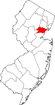 | |
| Boroughs | ||
| Town | ||
| Townships | ||
| CDPs | ||
|
Other communities | ||

| National | |
|---|---|
| Geographic | |
Westfield, New Jersey | |
|---|---|
|
Downtown Westfield | |
|
Seal | |
|
Map of Westfield in
Union County. Inset: Location of Union County highlighted in the State of
New Jersey. | |
|
Census Bureau map of Westfield, New Jersey | |
Westfield Location in
Union County Westfield Location in
New Jersey Westfield Location in the United States | |
| Coordinates: 40°39′06″N 74°20′36″W / 40.651644°N 74.343447°W [1] [2] | |
| Country | |
| State | |
| County | Union |
| Formed | January 27, 1794 |
| Incorporated | February 21, 1798 (as township) |
| Reincorporated | March 4, 1903 (as town) |
| Government | |
| • Type | Special charter |
| • Body | Town Council |
| • Mayor | Shelley Brindle ( D, term ends December 31, 2025) [3] [4] |
| • Administrator | James H. Gildea [5] |
| • Municipal clerk | Maureen Lawshe [6] |
| Area | |
| • Total | 6.74 sq mi (17.46 km2) |
| • Land | 6.72 sq mi (17.42 km2) |
| • Water | 0.02 sq mi (0.05 km2) 0.28% |
| • Rank | 246th of 565 in state 5th of 21 in county [1] |
| Elevation | 118 ft (36 m) |
| Population | |
| • Total | 31,032 |
| • Estimate | 30,559 |
| • Rank | 77th of 565 in state 5th of 21 in county [13] |
| • Density | 4,615.1/sq mi (1,781.9/km2) |
| • Rank | 126th of 565 in state 12th of 21 in county [13] |
| Time zone | UTC−05:00 ( Eastern (EST)) |
| • Summer ( DST) | UTC−04:00 ( Eastern (EDT)) |
| ZIP Codes | 07090–07091
[14] |
| Area code | 908 [15] |
| FIPS code | 3403979040 [1] [16] [17] |
| GNIS feature ID | 0885436 [1] [18] |
| Website |
www |
Westfield is a town in Union County, in the U.S. state of New Jersey, located 16 miles (26 km) southwest of Manhattan. As of the 2020 United States census, the town's population was 31,032, [10] [11] an increase of 716 (+2.4%) from the 2010 census count of 30,316, [19] [20] which in turn reflected an increase of 672 (+2.3%) from the 29,644 counted in the 2000 census. [21]
In March 2018, Bloomberg ranked Westfield as the 99th highest-income place in the United States, and the 18th highest-income location in New Jersey. [22] According to a 2014 nationwide survey, Westfield was ranked as the 30th-safest city to live in the United States. [23]
The town has been one of the state's highest-income communities. Based on data from the American Community Survey for 2013–2017, Westfield residents had a median household income of $159,923, ranked 8th in the state among municipalities with more than 10,000 residents, more than double the statewide median of $76,475. [24]
History
History says that Westfield took its name from the rich "fields west of Elizabeth Town, and hence for over one hundred years went by the name of West Fields." Town records say that "the settlement of Westfield dates back to the last year (1699) of the seventeenth century. It was the result of the 'Clinker Lot Division.' Almost immediately after the division emigration from the older parts of the town of Elizabeth began to set towards the interior,—especially to the territory lying between the Rahway river, on the east, and the mountains, on the west. It was not, however, until 1720 that the settlers became numerous enough to constitute a distinct community." [25] The old village area, now the downtown district, was settled in 1720 as part of the Elizabethtown Tract.
Westfield was originally formed as a township on January 27, 1794, from portions of Elizabeth Township, while the area was still part of Essex County, and was incorporated on February 21, 1798, as one of New Jersey's initial group of 104 townships by an act of the New Jersey Legislature. It became part of the newly formed Union County on March 19, 1857. Portions of the township have been taken to form Rahway Township (February 27, 1804), Plainfield Township (April 5, 1847), Cranford Township (March 14, 1871), Fanwood Township (March 6, 1878; now known as Scotch Plains) and Mountainside (September 25, 1895). The Town of Westfield was incorporated on March 4, 1903, replacing Westfield Township. [26] [27] The name of the town is derived from its location in the western, undeveloped fields of the Elizabethtown tract. [28] [29]
Geography
According to the United States Census Bureau, the town had a total area of 6.74 square miles (17.46 km2), including 6.72 square miles (17.42 km2) of land and 0.02 square miles (0.05 km2) of water (0.28%). [1] [2]
Unincorporated communities, localities and place names located partially or completely within the township include Germantown and Tamaques Reservation Mill. [30]
Six municipalities border the town of Westfield: Mountainside to the north, Springfield Township to the northeast, Garwood and Cranford to the east, Clark to the southeast, and Scotch Plains to the west and southwest. [31] [32] [33]
The upper reaches of the Rahway River Parkway run through the township along tributaries of the Rahway River. [34]
The Robinson's Branch of the Rahway River additionally flows through the southern portion of Westfield en route to the Robinson's Branch Reservoir, also known as the Clark Reservoir.
It is located about one hour from Manhattan.
Community
Library
The Westfield Memorial Library was founded in 1873 as the "Every Saturday Book Club" and has evolved over the past century into the Westfield Memorial Library of today. The Library is located in a large, modern, Williamsburg-style building at 550 East Broad Street. The library's collection consists of over 250,000 books, two dozen public computers, a wide array of multimedia options, a large youth services area with a vivid mural depicting Westfield history, and multiple tables and carrels for studying. The library offers classes for adults and children, storytimes for children, and computer instruction. [35]
Downtown
Westfield's downtown features many local and national stores and several landmarks that were shown and used in the NBC network television show Ed such as the Rialto Theater. There are over 40 restaurants and casual dining establishments throughout the downtown. Downtown is located mostly north of the Westfield train station. The downtown area has a mix of independent stores and boutiques as well as national stores. Over one-third of the retailers and restaurants have existed for 25 years or more.
Downtown Westfield, with over 200 retail establishments and 400 commercial enterprises, is a regional destination in New Jersey. The Downtown Westfield Corporation (DWC) manages the Special Improvement District (SID) area's growth and enhancement. The DWC participates in the National Main Street program associated with the National Trust for Historic Preservation. It is funded by a SID assessment on downtown properties and operates as the district's management agency. The DWC sponsors marketing efforts and promotions, special event planning, urban design and building improvement projects. The DWC works closely with the town government and volunteer groups to improve the downtown area. In 2004, Westfield won the Great American Main Street Award from the National Trust. [36] In 2010, Westfield was the winner of the America in Bloom contest for communities with a population of 25,001–50,000 against the other two towns entered in their category. [37] Shopping and dining in Westfield attracts citizens from other communities across the state.
Several war memorials (including ones dedicated to the Korean War, World War II, Spanish–American War, and the Vietnam War) are located in a plaza near the downtown. The plaza is also home to the September 11 Memorial Park, which pays special tribute to the residents of Westfield who died in the September 11 terrorist attacks. [38] [39]
Downtown Westfield hosts events and festivals throughout the year. Throughout the summer, jazz groups perform live, outdoors, every Tuesday night. [40] October 2018 saw the first annual AddamsFest, honoring Westfield resident Charles Addams. The festival featured exhibits, lectures, film screenings, and a masquerade ball, among other things. [41] Other festivals include the Spring Fling and FestiFall. [42]
In August 2020, Le Tote announced that Lord & Taylor, the town's only department store and the chain's only freestanding location in New Jersey, would close as part of a plan to shut down 38 Lord & Taylor store nationwide. Efforts are being made to redevelop the site. [43]
Parks and recreation
Parks in the town include: [44]
- Brightwood Park
- Gumbert Park
- Lenape Park, is a 450-acre (180 ha) wildlife reserve and park that is part of Union County's Rahway River Parkway. The park also includes portions of Cranford, Kenilworth and Springfield Township. [45] An approximately 4.5-mile off-road paved pedestrian path stretches eastbound from Mountainside Police Headquarters in Mountainside, through Echo Lake Park in Westfield, Lenape Park in Westfield and Cranford, Black Brook Park in Kenilworth, and ending near 505 North Michigan Avenue in Kenilworth.
- Mindowaskin Park
- Tamaques Park
- Gary Kehler Stadium is named in honor of Gary Kehler (1931–2007), the former Westfield High School football coach and long-time town resident. [46]
Demographics
| Census | Pop. | Note | %± |
|---|---|---|---|
| 1810 | 2,152 | — | |
| 1820 | 2,358 | 9.6% | |
| 1830 | 2,492 | 5.7% | |
| 1840 | 3,150 | 26.4% | |
| 1850 | 1,577 | * | −49.9% |
| 1860 | 1,719 | 9.0% | |
| 1870 | 2,753 | 60.2% | |
| 1880 | 2,216 | * | −19.5% |
| 1890 | 2,739 | 23.6% | |
| 1900 | 4,328 | * | 58.0% |
| 1910 | 6,420 | 48.3% | |
| 1920 | 9,063 | * | 41.2% |
| 1930 | 15,801 | 74.3% | |
| 1940 | 18,458 | 16.8% | |
| 1950 | 21,243 | 15.1% | |
| 1960 | 31,447 | 48.0% | |
| 1970 | 33,720 | 7.2% | |
| 1980 | 30,447 | −9.7% | |
| 1990 | 28,870 | −5.2% | |
| 2000 | 29,644 | 2.7% | |
| 2010 | 30,316 | 2.3% | |
| 2020 | 31,032 | 2.4% | |
| 2023 (est.) | 30,559 | [10] [12] | −1.5% |
| Population sources: 1810–1920 [47] 1840 [48] 1850–1870 [49] 1850 [50] 1870 [51] 1880–1890 [52] 1890–1910 [53] 1910–1930 [54] 1940–2000 [55] 2000 [56] [57] 2010 [19] [20] [58] 2020 [10] [11] * = Lost territory in previous decade. [26] | |||
2010 census
The 2010 United States census counted 30,316 people, 10,566 households, and 8,199 families in the town. The population density was 4,512.2 per square mile (1,742.2/km2). There were 10,950 housing units at an average density of 1,629.8 per square mile (629.3/km2). The racial makeup was 88.17% (26,729) White, 3.25% (984) Black or African American, 0.12% (36) Native American, 5.67% (1,718) Asian, 0.03% (10) Pacific Islander, 0.79% (241) from other races, and 1.97% (598) from two or more races. Hispanic or Latino of any race were 4.92% (1,492) of the population. [19]
Of the 10,566 households, 43.1% had children under the age of 18; 68.0% were married couples living together; 7.5% had a female householder with no husband present and 22.4% were non-families. Of all households, 19.2% were made up of individuals and 9.8% had someone living alone who was 65 years of age or older. The average household size was 2.85 and the average family size was 3.31. [19]
30.0% of the population were under the age of 18, 4.7% from 18 to 24, 22.5% from 25 to 44, 29.7% from 45 to 64, and 13.1% who were 65 years of age or older. The median age was 41.0 years. For every 100 females, the population had 92.7 males. For every 100 females ages 18 and older there were 87.2 males. [19]
The Census Bureau's 2006–2010 American Community Survey showed that (in 2010 inflation-adjusted dollars) median household income was $127,799 (with a margin of error of +/− $10,580) and the median family income was $150,797 (+/− $11,480). Males had a median income of $111,762 (+/− $7,767) versus $71,217 (+/− $5,624) for females. The per capita income for the town was $63,498 (+/− $4,577). About 0.9% of families and 2.3% of the population were below the poverty line, including 2.4% of those under age 18 and 2.0% of those age 65 or over. [59]
2000 census
As of the 2000 United States census [16] there were 29,644 people, 10,622 households, and 8,178 families residing in the town. The population density was 4,403.1 inhabitants per square mile (1,700.0/km2). There were 10,819 housing units at an average density of 1,607.0 per square mile (620.5/km2). The racial makeup of the town was 89.98% White, 3.88% African American, 0.09% Native American, 4.08% Asian, 0.01% Pacific Islander, 0.62% from other races, and 1.33% from two or more races. Hispanic or Latino of any race were 2.82% of the population. [56] [57]
There were 10,622 households, out of which 40.8% had children under the age of 18 living with them, 68.0% were married couples living together, 7.1% had a female householder with no husband present, and 23.0% were non-families. Of all households, 19.3% were made up of individuals, and 9.4% had someone living alone who was 65 years of age or older. The average household size was 2.77 and the average family size was 3.20. [56] [57]
In the town, the population was spread out, with 28.4% under the age of 18, 4.0% from 18 to 24, 29.6% from 25 to 44, 24.5% from 45 to 64, and 13.5% who were 65 years of age or older. The median age was 39 years. For every 100 females, there were 92.1 males. For every 100 females age 18 and over, there were 87.4 males. [56] [57]
The median income for a household in the town was $98,390, and the median income for a family was $112,145. Males had a median income of $82,420 versus $45,305 for females. The per capita income for the town was $47,187. About 1.7% of families and 2.7% of the population were below the poverty line, including 3.3% of those under age 18 and 3.1% of those age 65 or over. [56] [57]
Government
Local government
Westfield is governed under a special charter granted by an act of the New Jersey Legislature. The town is one of 11 municipalities (of the 564) statewide that operate under special charters. [60] [61] The governing body is comprised of a Mayor and an eight-member Town Council, with all positions filled in partisan elections. The Mayor is elected directly by the voters at-large to a four-year term of office. The Town Council consists of eight members, with two members elected from each of four wards. Town Council members are elected to serve four-year terms on a staggered basis, with one seat in each ward coming up for election every other year. [7] The Town Council holds meetings every two weeks where it discusses legislation under consideration, and which are open to the public.
As of 2024 [update], the Mayor of Westfield is Democrat Michelle W. "Shelley" Brindle, whose term of office ends on December 31, 2025. [62] Members of the Westfield Town Council are Michael Armento (Ward 2; R, 2027), David M. Contract (Ward 3; D, 2025), Michael J. Dardia (Ward 2; D, 2025), Michal D. Domogala (Ward 3; , 2027), Linda S. Habgood (Ward 1; D, 2025), David Kiefer (Ward 4; D, 2027), Dawn Mackey (Ward 4; D, 2025), and Todd B. Saunders (Ward 1; R, 2027). [3] [63] [64] [65] [66]
In April 2022, the Town Council selected Emily Root from a list of three alternatives submitted by the Democratic municipal committee to fill the Ward 1 seat expiring in December 2023 that had been held by James Boyes until he resigned from office earlier that month. Root served on an interim basis until the November 2022 general election, when voters then selected her to serve the balance of the original term of office. [67]
Emergency services
Police
The Westfield Police Department (WPD) has provided police protection to the town since 1903. The chief of police is Christopher Battiloro, who was appointed to the position in December 2018, after serving for four months on an interim basis. [68] The department operates a Patrol Division, Traffic Safety Bureau, Records Bureau, Detective Bureau and its own Emergency Services Unit. Westfield's Parking Services also falls under the jurisdiction of the WPD, and is responsible for monitoring parking and traffic safety within Westfield's Central Business District and near schools. The WPD also has a Law Enforcement Explorers Post, Post #90. [69] Each division of the WPD operates different vehicles, most with a black-and-white paint scheme.
Fire
The Westfield Fire Department was formed in 1875 following a fire that destroyed a city block on East Broad Street. [70] The WFD is a combination department with 36 paid/career firefighters and 15 volunteer firefighters. There are four platoons of eight (a Battalion Chief, two Lieutenants and five Firefighters) working a 24-/72-hour work schedule out of two fire stations. Administrative members include the Chief of Department, the Deputy Chief of Operations, and the Deputy Chief of Fire Prevention. The Fire Safety Inspector position in the Fire Prevention Bureau was eliminated in January 2009 due to budget cuts. The Chief of Department is Anthony Tiller. [71]
Westfield Fire Headquarters, located at 405 North Avenue West, is staffed 24 hours a day by a Battalion Chief (Shift Commander), a lieutenant and three firefighters. These personnel make up the engine company, first due on the north side of town, and the ladder company. A reserve engine company and a utility pick-up are also housed at fire headquarters. The office of the Chief of Department and the Deputy Chief of Operations are located here as well.
Station 2, located at 1029 Central Avenue, is staffed 24 hours a day by a lieutenant and two firefighters. These personnel make up the engine company, first due on the south side of town. A reserve engine company, a utility pick-up, and a spare SUV are also housed at Station 2. The Fire Prevention Bureau is located at Station 2 and houses the office of the Deputy Chief of Fire Prevention.
The WFD in operates a fleet of four E-One Engines (2 x 2,000 GPM & 2 x 1,500 GPM) and 1 Pierce Arrow XT 100' Rearmount Ladder, one support SUV, and three staff 4x4 vehicles. The paint scheme for the older apparatus (Engine 4) is yellow, with the newer apparatus (Ladder 1, Engines 2, 3 & 5) being red bodies with white cabs. The support vehicles, a Ford Pick-Up (Utility 7), a Chevy Pick-Up (Utility 8), and a Jeep Cherokee (Car 9) are red with white striping and the remaining staff vehicles, for Chief Officers, are unmarked Dodge Durangos (Car 1,11,12).
The WFD responds annually to approximately 2,000 calls for service. The WFD serves as a backup EMS agency for the town if the Westfield Volunteer Rescue Squad is not readily available. All members are CPR-Defib certified with 27 members currently New Jersey certified EMTs with the remaining members trained to the first responder level. Both stations are staffed with FF/EMTs 24 hours a day.
The WFD is also a partner in the Union County Fire Mutual Aid agreement, responding to numerous requests for aid to any of the other 20 municipalities in Union County. [72]
The career firefighters (excluding the Chief and Deputy Chiefs) are members of New Jersey Firefighter's Mutual Benevolent Association (NJ FMBA) Local 30. [73]
Rescue squad
The Westfield Volunteer Rescue Squad is staffed around the clock by volunteer certified EMTs. Shifts range from 5 hours in the morning and afternoon to 14 hours overnight. The Squad has three ambulances with a crew every shift. Members are paged in the event that another emergency arises and the original crew is answering a medical call. Dispatchers are also volunteers, answering phones directly from the police line. [74]
Federal, state and county representation
Westfield is located in the 7th Congressional District [75] and is part of New Jersey's 21st state legislative district. [76] [77] [78]
For the 118th United States Congress, New Jersey's 7th congressional district is represented by Thomas Kean Jr. ( R, Westfield). [79] New Jersey is represented in the United States Senate by Democrats Cory Booker ( Newark, term ends 2027) [80] and Bob Menendez ( Englewood Cliffs, term ends 2025). [81] [82]
For the 2024-2025 session, the 21st legislative district of the New Jersey Legislature is represented in the State Senate by Jon Bramnick ( R, Westfield) and in the General Assembly by Michele Matsikoudis (R, New Providence) and Nancy Munoz (R, Summit). [83]
Union County is governed by a Board of County Commissioners, whose nine members are elected at-large to three-year terms of office on a staggered basis with three seats coming up for election each year, with an appointed County Manager overseeing the day-to-day operations of the county. At an annual reorganization meeting held in the beginning of January, the board selects a Chair and Vice Chair from among its members. [84] As of 2024 [update], Union County's County Commissioners are:
Rebecca Williams ( D, Plainfield, 2025), [85] Joesph Bodek (D, Linden, 2026), [86] James E. Baker Jr. (D, Rahway, 2024), [87] Michele Delisfort (D, Union Township, 2026), [88] Sergio Granados (D, Elizabeth, 2025), [89] Bette Jane Kowalski (D, Cranford, 2025), [90] Vice Chair Lourdes M. Leon (D, Elizabeth, 2026), [91] Alexander Mirabella (D, Fanwood, 2024) [92] and Chair Kimberly Palmieri-Mouded (D, Westfield, 2024). [93] [94]
Constitutional officers elected on a countywide basis are: Clerk Joanne Rajoppi (D, Union Township, 2025), [95] [96] Sheriff Peter Corvelli (D, Kenilworth, 2026) [97] [98] and Surrogate Christopher E. Hudak (D, Clark, 2027). [99] [100]
Politics
As of March 2011, there were a total of 20,684 registered voters in Westfield, of which 6,485 (31.4% vs. 41.8% countywide) were registered as Democrats, 5,244 (25.4% vs. 15.3%) were registered as Republicans and 8,942 (43.2% vs. 42.9%) were registered as Unaffiliated. There were 13 voters registered as Libertarians or Greens. [101] Among the town's 2010 Census population, 68.2% (vs. 53.3% in Union County) were registered to vote, including 97.5% of those ages 18 and over (vs. 70.6% countywide). [101] [102]
In the 2012 presidential election, Democrat Barack Obama received 8,080 votes (50.9% vs. 66.0% countywide), ahead of Republican Mitt Romney with 7,555 votes (47.6% vs. 32.3%) and other candidates with 147 votes (0.9% vs. 0.8%), among the 15,866 ballots cast by the town's 21,797 registered voters, for a turnout of 72.8% (vs. 68.8% in Union County). [103] [104] In the 2008 presidential election, Democrat Barack Obama received 9,345 votes (54.5% vs. 63.1% countywide), ahead of Republican John McCain with 7,541 votes (44.0% vs. 35.2%) and other candidates with 154 votes (0.9% vs. 0.9%), among the 17,141 ballots cast by the town's 21,251 registered voters, for a turnout of 80.7% (vs. 74.7% in Union County). [105] In the 2004 presidential election, Democrat John Kerry received 8,442 votes (50.6% vs. 58.3% countywide), ahead of Republican George W. Bush with 8,037 votes (48.2% vs. 40.3%) and other candidates with 110 votes (0.7% vs. 0.7%), among the 16,683 ballots cast by the town's 20,441 registered voters, for a turnout of 81.6% (vs. 72.3% in the whole county). [106]
In the 2013 gubernatorial election, Republican Chris Christie received 64.1% of the vote (6,303 cast), ahead of Democrat Barbara Buono with 34.5% (3,394 votes), and other candidates with 1.3% (131 votes), among the 10,053 ballots cast by the town's 21,513 registered voters (225 ballots were spoiled), for a turnout of 46.7%. [107] [108] In the 2009 gubernatorial election, Republican Chris Christie received 6,070 votes (51.0% vs. 41.7% countywide), ahead of Democrat Jon Corzine with 4,776 votes (40.2% vs. 50.6%), Independent Chris Daggett with 900 votes (7.6% vs. 5.9%) and other candidates with 58 votes (0.5% vs. 0.8%), among the 11,893 ballots cast by the town's 20,982 registered voters, yielding a 56.7% turnout (vs. 46.5% in the county). [109]
Education
Public school students in pre-kindergarten through twelfth grades attend the Westfield Public Schools. [110] As of the 2018–19 school year, the district, comprised of 10 schools, had an enrollment of 6,304 students and 500.4 classroom teachers (on an FTE basis), for a student–teacher ratio of 12.6:1. [111] The district has a central kindergarten, six neighborhood elementary schools (grades 1–5), two middle schools (grades 6–8) divided by a "North Side / South Side" boundary, and one high school (grades 9–12). [112] The schools in the district (with 2018–19 enrollment data from the National Center for Education Statistics [113]) are Lincoln Early Childhood Center [114] (with 310 students; in grades Pre-K–K), Franklin Elementary School [115] (580; 1–5 – North), Jefferson Elementary School [116] (442; 1–5 – South), McKinley Elementary School [117] (341; 1–5 – South), Tamaques Elementary School [118] (401; 1–5 – South), Washington Elementary School [119] (309; 1–5 – North), Wilson Elementary School [120] (355; 1–5 – North), Roosevelt Intermediate School [121] (777; 6–8 – North), Thomas Alva Edison Intermediate School [122] (844; 6–8 – South) and Westfield High School [123] (1,865; 9–12). [124] [125]
For high school, public school students from Westfield and all of Union County are eligible to apply to attend the Union County Vocational Technical Schools, which include Union County Magnet High School, Union County Academy for Information Technology, Union County Academy for Allied Health Sciences, Union County Vocational Technical High School and Union County Academy for Performing Arts. [126]
Holy Trinity School is a Middle States-accredited Catholic school run by the three parishes of Holy Trinity and St. Helen's in Westfield along with Our Lady of Lourdes in Mountainside, which offers education from pre-kindergarten to 8th grade and operates under the auspices of the Roman Catholic Archdiocese of Newark. [127] [128]
Transportation
Roads and highways
As of May 2010 [update], the town had a total of 108.63 miles (174.82 km) of roadways, of which 96.69 miles (155.61 km) were maintained by the municipality, 9.94 miles (16.00 km) by Union County and 2.00 miles (3.22 km) by the New Jersey Department of Transportation. [129]
The main road serving Westfield is Route 28, which runs for about two miles alongside the commuter railroad that marks the boundary between the town's North and South Sides. Westfield can also be accessed by Exits 135 and 137 of the nearby Garden State Parkway, or by the Lawrence, Mountain, or Springfield Avenue exits of U.S. Route 22.
Public transportation
NJ Transit (NJT) provides passenger rail service from the Westfield train station. [130] Commuter rail service is offered on the Raritan Valley Line to Newark Penn Station with connecting service to New York Penn Station. [131] Westfield riders are able to make a one-seat ride (no transfer necessary) into NY Penn Station during weekday off-peak hours, which was made possible by upgrades of the NJT train equipment to operate into New York City. Westfield's position and schedule on the Raritan Valley Line make it desirable for commuters, as several times in the morning and evening rush hours a non-stop service operates to/from Newark Penn Station. On these non-stop services, the one-way journey time to/from NY Penn Station is 50 minutes, or 20 minutes to/from Newark Penn Station.
The NJ Transit 113 bus route provides one-seat service to New York City's Port Authority Bus Terminal seven days per week from the town center, taking approximately one hour to NYC, with additional service available along Route 22 on the northern edge of the town (NJT bus routes 114 and 117), taking approximately 45 minutes. The 59 route provides local bus service between Plainfield and Newark. [132]
Newark Liberty International Airport is approximately 20 minutes away, most conveniently reached via Route 22 or NJT trains. Linden Airport, a general aviation facility, is in nearby Linden, New Jersey.
Services
Residential telephone service is provided by Verizon Communications. Westfield cable television is supplied by Comcast [1], which also delivers Westfield Community Television (channel 36), [133] News 12 New Jersey (channel 62), and Scotch Plains Local Access Channel (channel 34) [134] Verizon FiOS is also offered in Westfield, which gives the option of digital cable, high-speed internet and telephone service. Power is supplied through the Public Service Electric and Gas Company. Gas is supplied by Elizabethtown Gas and water by American Water of New Jersey. Recycling is collected curbside by private haulers contracted by the Department of Public Works on a biweekly basis, while trash is collected by private haulers hired by residents.
Media
Westfield is served by the locally published weekly newspaper, The Westfield Leader. [135] The Record-Press had served the community until it ended publication in 2008. Westfield is also served by multi-community newspapers including the Courier News, a daily newspaper based in Bridgewater Township, and The Star-Ledger based in Newark. Westfield Patch is an online news source dedicated strictly to local Westfield news that is updated around the clock by a small staff of paid editors and volunteer contributors. Likewise, TAPInto Westfield is an online news source dedicated to local Westfield news. [136]
Westfield + Cranford Local is a monthly magazine covering the two towns that launched in the early 2020s. [137]
Westfield Community Television (WCT)
The local community access channel 36 operates out of the Municipal Building on Broad Street in Westfield on Mondays, Wednesdays, Fridays and half of every Sunday. WCT provides limited community-related programming, coverage of town council meetings, and operates the WCT Bulletin Board. WCT shares time on channel 36 with Blue Devil Television, which originates from Westfield High School and produces nearly 200 original productions each academic year. [138]
Culture
The Greek Orthodox Archdiocese of America Metropolis of New Jersey is headquartered in Westfield. [139]
Notable people
People who were born in, residents of, or otherwise closely associated with Westfield include:
- Marc Acito (born 1966), playwright, novelist and humorist [140]
- Charles Addams (1912–1988), cartoonist for The New Yorker magazine, most famous for his cartoons of The Addams Family [141]
- Kim Alsop (born c. 1933), former head coach of the Samford Bulldogs football team [142]
- Steve Angeli, American football quarterback for the Notre Dame Fighting Irish. [143]
- Charles E. Apgar (1865–1950), business executive and amateur radio operator best known for making early recordings of German radio transmissions at the start of World War I [144]
- Virginia Apgar (1909–1974), creator of the Apgar score for assessing health of newborns [145]
- Billy Ard (born 1959), former NFL guard for the New York Giants and Green Bay Packers [146]
- H. W. Ambruster (1879–1961), football coach, chemical engineer, actor and lecturer [147]
- Omar Ashmawy, staff director and chief counsel of the Office of Congressional Ethics [148]
- Richard Bagger (born 1960), former mayor, who served as chief of staff for Governor of New Jersey Chris Christie [149] [150]
- Robert L. Barchi (born 1946), twentieth president of Rutgers University, 2012-2020 [151] [152]
- Cheryl Barnes, singer and actress best known for her role in Miloš Forman's 1979 film adaptation of Hair, where she played the mother of Hud's little son [153]
- Carolyn Beebe (1873–1950), pianist who was a founder of the New York Chamber Music Society [154]
- Bryan Beller (born 1971), bass guitarist known for his work with Mike Keneally, Steve Vai, Dethklok, James LaBrie of Dream Theater and Dweezil Zappa [155]
- Jon Bramnick (born 1953), member of the New Jersey General Assembly who has represented the 21st Legislative District since 2003 [150] [156]
- Brock Brower (1931–2014), novelist, magazine journalist and TV writer [157]
- Dave Brown (born 1970), NFL quarterback who played for the New York Giants and Arizona Cardinals [158] [159]
- Steve Brozak (born 1961), Managing Partner and President of WBB Securities, LLC, a Democratic congressional candidate in the 2004 election cycle and the Chairman and CEO of StormBio, Inc. [160]
- Robert N. Buck (1914–2007), aviator and author who broke 14 junior airspeed records in the 1930s, started his flying career at the Westfield Airport [161]
- Alan Bunce (1900–1965), radio and television actor [162]
- Devin Caherly (born 2001, class of 2019), social media personality [163]
- Chris Campbell (born 1954), wrestler who won a bronze medalist in Freestyle wrestling at the 1992 Summer Olympics [164]
- Gil Chapman (born 1953), running back and return specialist for the University of Michigan and New Orleans Saints [165]
- Steve Cheek (born 1977), NFL punter, 2001–2005 ( San Francisco 49ers, Kansas City Chiefs, Carolina Panthers) [166]
- Michael Chertoff (born 1953), United States Secretary of Homeland Security and former United States district court Judge [167] [168]
- John Chironna (1928–2010), head coach of the Rhode Island Rams football team in 1961 and 1962 [169]
- Chris Christie (born 1962), Governor of New Jersey, who lived in Westfield for a year while his home in Mendham was under construction [150]
- Bob Clotworthy (1931–2018), diver who competed in the 3 m springboard at the 1952 and 1956 Olympics and won a bronze and a gold medal, respectively [170]
- Grover Connell (1918–2018), rice trader and longtime member of the Forbes 400 [171]
- Pat Cosquer (born 1975), college squash coach [172]
- John Cuneo (born 1957), illustrator, whose work has appeared in The New Yorker, Esquire, Sports Illustrated and The Atlantic [173]
- Nicholas Delpopolo (born 1989), judoka who has represented the United States at the 2012 Summer Olympics and 2016 Summer Olympics [174]
- Robert S. Dietz (1914–1995), marine geologist, geophysicist and oceanographer who conducted pioneering research concerning seafloor spreading [175]
- Tamecka Dixon (born 1975), former USA national team and WNBA player who played for the Los Angeles Sparks, Houston Comets and Indiana Fever [176] [177]
- Alexander Wilson Drake (1843–1916), artist, collector and critic [178]
- Sara Driver (born 1955), independent filmmaker [179]
- Michael DuHaime (born 1974), Republican strategist and public affairs executive [150] [180]
- Geoff Edwards (1931–2014), actor and game show host [181]
- Edward Einhorn (born 1970), children's author, director and playwright [182]
- Mike Emanuel (born 1967), Washington correspondent for Fox News [183]
- Gail Falkenberg (born 1947), professional tennis player, who may be the oldest tournament tennis player of all time, having competed in ITF Women's World Tennis Tour tournaments as recently as 2021, at age 74 [184]
- Thomas Farley, pediatrician who served as the commissioner of the Philadelphia Department of Health [185]
- Kevin Feige (born 1973), film producer and President of Marvel Studios [186]
- Michael Fennelly (born 1949), rock guitarist, singer and songwriter who performed with The Millennium and Crabby Appleton [187]
- Gerald Foster (1900–1987), painter who competed in the painting event in the art competition at the 1932 Summer Olympics [188]
- William Chapman Foster (1897–1984), businessman and high-ranking government official who negotiated multiple arms control treaties [189]
- Nona Garson (born 1958), equestrian who competed in team jumping and individual jumping at the 2000 Summer Olympics in Sydney [190]
- GH057ayame (gamer tag of Eric Hewitt), retired professional Major League Gaming gamer who works for 343 Industries working on future Halo games [191]
- Gina Glantz (born c. 1943), political strategist, campaign manager, field director and consultant [192] [193]
- John Duval Gluck (1878–1951), philanthropist, customs broker and con artist who is best known for popularizing the practice of sending and answering letters to Santa Claus in New York City [194]
- Dan Graham (born 1942), artist, writer, and curator [195]
- Joseph Greenspan (born 1992), soccer player for the Pittsburgh Riverhounds SC of the United Soccer League [196]
- Robert Greifeld (born 1957), CEO of NASDAQ-OMX [197] [198]
- Matt Gutman (born 1977), ABC News correspondent [199]
- Harry Hanan (1916–1982), cartoonist of the syndicated comic strip Louie [200]
- Kenneth Hand (1899–1988), politician and judge who served in the New Jersey Senate [201]
- Walt Hansgen (1919–1966), race car driver [202]
- Chuck Hardwick (born 1941), politician and business leader who served as Speaker of the New Jersey General Assembly and was a candidate for Governor of New Jersey [203]
- Langston Hughes (1902–1967), poet [204] [205]
- Clark Hulings (1922–2011), realist artist [206]
- Zora Neale Hurston (1891–1960), folklorist [204] [207]
- Scott Jacobs (born 1958), painter known for his photorealistic work of Harley-Davidson motorcycles, who became the company's first official licensed artist in 1993 [208]
- Robert Kaplow (born 1954), teacher and novelist whose coming-of-age novel was made into a film titled Me and Orson Welles [209] [210]
- Thomas Kean Jr. (born 1968), New Jersey State Senator and son of former Governor of New Jersey Thomas Kean [150] [211] [212]
- Mary Jo Keenen, actress who appeared on Nurses [213]
- Kevin Kelly (born 1952), founder of Wired magazine [214]
- Robert Kirsch (born 1966), state court judge from New Jersey who is a nominee to serve as a United States district judge of the United States District Court for the District of New Jersey. [215]
- Martin Kunert (born 1970), film director and TV writer/producer of Voices of Iraq, MTV's Fear and Campfire Tales [216]
- Christian J. Lambertsen (1917–2011), "the father of the Frogmen" [217]
- Marilyn Lange (born 1952), Playboy Playmate for May 1974 and Playmate of the Year for 1975 [218]
- Margaret Carver Leighton (1896–1987), children's author [219]
- Ira Lewis (1932–2015), actor and playwright, whose works included Chinese Coffee [220]
- John List (1925–2008), murderer convicted in the deaths of his wife, mother and three children. Known as the "Boogeyman of Westfield" [221] [222]
- Matt Loughlin, sportscaster who is the radio play-by-play voice of the New Jersey Devils of the National Hockey League on WFAN [223]
- Andrew McCarthy (born 1962), actor who appeared in Weekend at Bernie's and is currently starring in The Family [224]
- Sy Montgomery (born 1958), naturalist, author and scriptwriter [225]
- Patrick Morrisey (born 1967), elected as Attorney General of West Virginia in 2012 [226]
- Rebecca Morse (born 1992), ice hockey defender, currently playing for the Metropolitan Riveters of the National Women's Hockey League [227]
- Laura Overdeck, entrepreneur and philanthropist who is the founder and president of Bedtime Math [228]
- Bill Palatucci (born 1958), attorney who is a member of the Republican National Committee and the New Jersey Apportionment Commission, and led the selection of staff for the presidential transition of Donald Trump [229]
- John S. Penn (1926–2013), politician who represented the 16th Legislative District in the New Jersey General Assembly from 1984 to 1994 [230]
- Randolph Perkins (1871–1936), mayor of Westfield from 1903 to 1905, and represented New Jersey's 6th congressional district from 1921 to 1936 [231] [232]
- Dave Perkowski (born 1947), former competition swimmer who represented the United States in the 100-meter breaststroke event at the 1968 Summer Olympics in Mexico City [233]
- Arthur N. Pierson (1867–1957), businessman and politician who served as Speaker of the New Jersey General Assembly and President of the New Jersey Senate [234]
- Anne Revere (1903-1990), actress who won the Academy Award for Best Supporting Actress for National Velvet and a Tony Award for her performance in Lillian Hellman's play Toys in the Attic in 1960. [235]
- Paul Robeson (1898–1976), athlete, actor, singer, political activist, NFL guard from 1920 to 1922 for the Akron Pros and Milwaukee Badgers [236] [237]
- Andrew K. Ruotolo (1952–1995), politician who served as the Union County, New Jersey, prosecutor [238]
- John Rzeznik (born 1965), lead singer of the Goo Goo Dolls [239] [240]
- Bret Schundler (born 1959), former Mayor of Jersey City and former New Jersey gubernatorial candidate [241] [242]
- Amos Scudder (1779–1856), architect and builder [243]
- Ephraim Scudder (1819–1872), builder [243]
- John Scudder (1815–1869), builder [243]
- Coleen Sexton (born 1979), actress who made her Broadway debut at age 20 in Jekyll & Hyde in 2000 [244]
- Matthew Sklar (born 1973), Tony Award and Emmy Award-nominated composer of Broadway musicals The Prom, Elf the Musical, and The Wedding Singer
- Jessica St. Clair (born 1976), actress and improvisational comedian [245]
- Dan Soucek (born 1969), North Carolina State Senator [246]
- Jeff Torborg (born 1941), MLB player and manager [247] [248]
- P. Roy Vagelos (born 1929), former Chairman and CEO of Merck & Co. [249]
- Jeffrey A. Warsh (born 1960), former member of the New Jersey General Assembly and Executive Director of NJ Transit [250] [251]
- Dave Weinstein (born 1988), appointed by Governor of New Jersey Chris Christie in 2016 to serve as the state's Chief Technology Officer [252]
- Roger Welch (born 1946), conceptual artist [253]
- Harrison A. Williams (1919–2001), U.S. Senator who was forced to resign in the face of expulsion due to his involvement in the Abscam case [254]
- Malinda Williams (born 1975), actress [255]
- Alfred M. Wolin (born 1932), former United States district judge of the United States District Court for the District of New Jersey. [256]
- Glen Everett Woolfenden (1930–2007), ornithologist, known for his long-term study of the Florida scrub jay population at Archbold Biological Station near Lake Placid, Florida [257]
- Harold "Butch" Woolfolk (born 1960), NFL running back from 1982 to 1988 who played for the New York Giants, Houston Oilers and Detroit Lions [258]
- Dan Yemin, punk rock guitarist [259]
Trivia
As recently as 2017, the Broaddus family living in Westfield received letters from a supposed stalker who referred to himself as "The Watcher," causing a national sensation. [260] The Broaddus family's experience, along with the 1971 John List family murders that also occurred in Westfield, were later adapted into the 2022 Netflix series The Watcher. [261]
References
- ^ a b c d e 2019 Census Gazetteer Files: New Jersey Places, United States Census Bureau. Accessed July 1, 2020.
- ^ a b US Gazetteer files: 2010, 2000, and 1990, United States Census Bureau. Accessed September 4, 2014.
- ^ a b Town Council, Town of Westfield. Accessed May 28, 2024.
- ^ 2023 New Jersey Mayors Directory, New Jersey Department of Community Affairs, updated February 8, 2023. Accessed February 10, 2023.
- ^ Administration, Town of Westfield. Accessed March 24, 2023.
- ^ Town Clerk, Town of Westfield. Accessed March 24, 2023.
- ^ a b 2012 New Jersey Legislative District Data Book, Rutgers University Edward J. Bloustein School of Planning and Public Policy, March 2013, p. 94.
- ^ "ArcGIS REST Services Directory". United States Census Bureau. Retrieved October 11, 2022.
- ^ "Town of Westfield". Geographic Names Information System. United States Geological Survey, United States Department of the Interior. Retrieved March 14, 2013.
- ^ a b c d e QuickFacts Westfield town, New Jersey, United States Census Bureau. Accessed December 13, 2022.
- ^ a b c Total Population: Census 2010 - Census 2020 New Jersey Municipalities, New Jersey Department of Labor and Workforce Development. Accessed December 1, 2022.
- ^ a b Annual Estimates of the Resident Population for Minor Civil Divisions in New Jersey: April 1, 2020 to July 1, 2023, United States Census Bureau, released May 2024. Accessed May 16, 2024.
- ^ a b Population Density by County and Municipality: New Jersey, 2020 and 2021, New Jersey Department of Labor and Workforce Development. Accessed March 1, 2023.
- ^ Look Up a ZIP Code for Westfield, NJ, United States Postal Service. Accessed March 3, 2012.
- ^ Area Code Lookup – NPA NXX for Westfield, NJ, Area-Codes.com. Accessed November 1, 2014.
- ^ a b U.S. Census website, United States Census Bureau. Accessed September 4, 2014.
- ^ Geographic Codes Lookup for New Jersey, Missouri Census Data Center. Accessed April 1, 2022.
- ^ US Board on Geographic Names, United States Geological Survey. Accessed September 4, 2014.
- ^ a b c d e DP-1 – Profile of General Population and Housing Characteristics: 2010 for Westfield town, Union County, New Jersey Archived February 12, 2020, at archive.today, United States Census Bureau. Accessed March 3, 2012.
- ^ a b Profile of General Demographic Characteristics: 2010 for Westfield town Archived August 9, 2013, at the Wayback Machine, New Jersey Department of Labor and Workforce Development. Accessed March 3, 2012.
- ^ Table 7. Population for the Counties and Municipalities in New Jersey: 1990, 2000 and 2010, New Jersey Department of Labor and Workforce Development, February 2011. Accessed May 1, 2023.
- ^ Hagan, Shelly; and Lu, Wei. "America’s 100 Richest Places: 2018", Bloomberg News, March 5, 2018. Accessed March 11, 2020.
- ^ Neighborhood Scout's America's Safest Cities 2014, Neighborhood Scout, backed up by the Internet Archive as of November 14, 2014. Accessed November 3, 2019.
- ^ Raychaudhuri, Disha. "The wealthiest towns in N.J., ranked", NJ Advance Media for NJ.com, June 7, 2019. Accessed November 4, 2019. "The median household income in N.J. is $76,475, recent Census data shows.... A note about the data: The data comes from 2013-2017 American Community Survey conducted by U.S. Census Bureau. Smaller towns with less than 10,000 residents were excluded from the list.... 8. Westfield, Union County Median income: $159,923"
- ^ Ricord, Frederick W. (1897). History of Union County New Jersey. Newark NJ: East Jersey History Company. p. 506.
- ^ a b Snyder, John P. The Story of New Jersey's Civil Boundaries: 1606–1968, Bureau of Geology and Topography; Trenton, New Jersey; 1969. p. 242. Accessed May 30, 2024.
- ^ Honeyman, Abraham Van Doren. Index-analysis of the Statutes of New Jersey, 1896-1909: Together with References to All Acts, and Parts of Acts, in the 'General Statutes' and Pamphlet Laws Expressly Repealed: and the Statutory Crimes of New Jersey During the Same Period, p. 313. New Jersey Law Journal Publishing Company, 1910. Accessed October 26, 2015.
- ^ Hutchinson, Viola L. The Origin of New Jersey Place Names, New Jersey Public Library Commission, May 1945. Accessed October 26, 2015.
- ^ Staff. "Westfield Historical Society Historic Marker installed at PNC Plaza", Suburban Trends, October 14, 2015. Accessed October 26, 2015. "The Westfield Historical Society (WHS) historic marker commemorating the settlement of Westfield in 1720 as the West Fields of Elizabethtown has been installed at the PNC Plaza, site of the Old York Road to Philadelphia."
- ^ Locality Search, State of New Jersey. Accessed May 21, 2015.
- ^ Areas touching Westfield, MapIt. Accessed March 11, 2020.
- ^ Union County Municipal Profiles, Union County, New Jersey. Accessed March 11, 2020.
- ^ New Jersey Municipal Boundaries, New Jersey Department of Transportation. Accessed November 15, 2019.
- ^ Our Parks, Friends of Rahway River Parkway. Accessed April 25, 2021.
- ^ History, Westfield Memorial Library. Accessed July 10, 2012.
- ^ Westfield, New Jersey: 2004 Great American Main Street Award Winner, National Trust for Historic Preservation, May 10, 2004. Accessed April 17, 2015.
- ^ Lipstein, Andrew. "Westfield Wins America in Bloom: Town beats Utah and Indiana communities as best town in population category.", WestfieldPatch, October 4, 2010. Accessed July 10, 2012. "The town received top honors Saturday for population category, beating two other communities during the annual America in Bloom contest.... The town beat out Murray City, Utah and Michigan City, Ind. for the top award in the 25,001 to 50,000 population category. For the landscaping award, the town beat all other communities entered in the competition."
- ^ September 11 Memorial Park Committee, Westfield Today. Accessed November 1, 2014.
- ^ Westfield Korean War Memorial, Westfield Today. Accessed November 1, 2014.
- ^ Westfield Today. Accessed January 9, 2019.
- ^ Westfield Patch. Accessed January 9, 2019.
- ^ "FestiFall in Westfield * ~".
- ^ Heapes, Richard. "An Open Letter to the Community of Westfield on Redevelopment", TAP into Westfield, December 16, 2020. Accessed December 27, 2020. "As many of you know, one of those businesses, Lord & Taylor, the entity owned and operated by Le Tote, is permanently closing its doors. It’s a difficult pill to swallow for shoppers that have relied upon and enjoyed the store, and for us, the owners of the property and an active member of the Westfield community for more than 30 years."
- ^ Parks, Town of Westfield. Accessed December 27, 2020.
- ^ Lenape Park, Union County, New Jersey, June 2014. Accessed December 27, 2020.
- ^ Kipp, Matt. "Westfield Re-Dedicates Renovated Gary Kehler Stadium", TAPinto.net, September 21, 2019. Accessed February 14, 2022. "With family members and friends of the stadium’s namesake — legendary Westfield head football coach Gary Kehler — on hand, accompanied by Westfield Board of Education members and town officials, the ribbon was officially cut from the 50-yard line"
- ^ Compendium of censuses 1726–1905: together with the tabulated returns of 1905, New Jersey Department of State, 1906. Accessed May 24, 2013.
- ^ Bowen, Francis. American Almanac and Repository of Useful Knowledge for the Year 1843, p. 231, David H. Williams, 1842. Accessed May 24, 2013. Source lists a population of 3,146 for 1840, in conflict with the 3,150 shown in the New Jersey Compendium of censuses 1726–1905.
- ^ Raum, John O. The History of New Jersey: From Its Earliest Settlement to the Present Time, Volume 1, p. 281, J. E. Potter and company, 1877. Accessed May 24, 2013. "Westfield had a population in 1860 of 1,719 and in 1870, 2,753."
- ^ Debow, James Dunwoody Brownson. The Seventh Census of the United States: 1850, p. 138. R. Armstrong, 1853. Accessed May 24, 2013.
- ^ Staff. A compendium of the ninth census, 1870, p. 261. United States Census Bureau, 1872. Accessed May 24, 2013.
- ^ Porter, Robert Percival. Preliminary Results as Contained in the Eleventh Census Bulletins: Volume III – 51 to 75, p. 99. United States Census Bureau, 1890. Accessed May 24, 2013.
- ^ Thirteenth Census of the United States, 1910: Population by Counties and Minor Civil Divisions, 1910, 1900, 1890, United States Census Bureau, p. 339. Accessed May 24, 2013.
- ^ Fifteenth Census of the United States : 1930 – Population Volume I, United States Census Bureau, p. 719. Accessed May 24, 2013.
- ^ Table 6: New Jersey Resident Population by Municipality: 1940 - 2000, Workforce New Jersey Public Information Network, August 2001. Accessed May 1, 2023.
- ^ a b c d e Census 2000 Profiles of Demographic / Social / Economic / Housing Characteristics for Westfield town, New Jersey Archived August 9, 2013, at the Wayback Machine, United States Census Bureau. Accessed March 1, 2012.
- ^ a b c d e DP-1: Profile of General Demographic Characteristics: 2000 – Census 2000 Summary File 1 (SF 1) 100-Percent Data for Westfield town, Union County, New Jersey Archived February 12, 2020, at archive.today, United States Census Bureau. Accessed December 5, 2012.
- ^ 2010 Census: Union County, Asbury Park Press. Accessed June 16, 2011.
- ^ DP03: Selected Economic Characteristics from the 2006–2010 American Community Survey 5-Year Estimates for Westfield town, Union County, New Jersey Archived February 12, 2020, at archive.today, United States Census Bureau. Accessed March 3, 2012.
- ^ Inventory of Municipal Forms of Government in New Jersey, Rutgers University Center for Government Studies, July 1, 2011. Accessed June 1, 2023.
- ^ "Forms of Municipal Government in New Jersey", p. 15. Rutgers University Center for Government Studies. Accessed June 1, 2023.
- ^ Mayor Shelley Brindle, Town of Westfield. Accessed March 28, 2023.
- ^ Union County Elected Officials, Union County, New Jersey Clerk. Accessed May 28, 2024.
- ^ General Election November 7, 2023 Official Results, Union County, New Jersey, updated November 22, 2023. Accessed January 3, 2024.
- ^ General Election November 8, 2022 Official Results, Union County, New Jersey, updated November 21, 2022. Accessed January 1, 2023.
- ^ General Election November 2, 2021 Official Results, Union County, New Jersey, updated November 15, 2021. Accessed January 3, 2022.
- ^ Wildstein, David. "Root appointed to vacant Westfield council seat Democrat fills vacancy created by resignation of James Boyes", New Jersey Globe, April 27, 2022. Accessed April 30, 2022. "Emily Root has been appointed to fill a vacant seat on the Westfield Township Council. She is replacing James Boyes, who resigned this month to obviate potential conflicts over a pair of redevelopment projects that are near his home. Root was one of three names submitted to the council by the Democratic County Committee.... Boyes was elected in 2019 and Root will need to run in a November 2022 special election to fill the remaining thirteen months of Boyce’s term."
- ^ Kadosh, Matt. "Chris Battiloro is Westfield's New Police Chief, Mayor Says", TAP into Westfield, December 12, 2018. Accessed January 6, 2019. "Mayor Shelley Brindle announced the appointment of Christopher Battiloro to the position of chief on Wednesday. Battiloro has been serving as the department’s acting chief for the past four months, following the abrupt departure of former Chief David Wayman."
- ^ "The Westfield Leader, May 15, 2008, page 4" (PDF).
- ^ History of the Westfield Fire Department, Town of Westfield. Accessed July 23, 2013.
- ^ Westfield Fire Department, Town of Westfield. Accessed April 25, 2021.
- ^ Mutual Aid, Union County, New Jersey. Accessed May 24, 2013.
- ^ Home page, Westfield FMBA Local #30. Accessed May 24, 2013.
- ^ Home Page, Westfield Volunteer Rescue Squad. Accessed July 23, 2013.
- ^ Plan Components Report, New Jersey Redistricting Commission, December 23, 2011. Accessed February 1, 2020.
- ^ Municipalities Sorted by 2011-2020 Legislative District, New Jersey Department of State. Accessed February 1, 2020.
- ^ 2019 New Jersey Citizen's Guide to Government, New Jersey League of Women Voters. Accessed October 30, 2019.
- ^ Districts by Number for 2011–2020, New Jersey Legislature. Accessed January 6, 2013.
- ^ "Congressman Malinowski Fights For The Corporate Transparency Act", Tom Malinowski, press release dated October 23, 2019. Accessed January 19, 2022. "My name, Tom Malinowski. My address, 86 Washington Street, Rocky Hill, NJ 08553."
- ^ U.S. Sen. Cory Booker cruises past Republican challenger Rik Mehta in New Jersey, PhillyVoice. Accessed April 30, 2021. "He now owns a home and lives in Newark's Central Ward community."
- ^ Biography of Bob Menendez, United States Senate, January 26, 2015. "Menendez, who started his political career in Union City, moved in September from Paramus to one of Harrison's new apartment buildings near the town's PATH station.."
- ^ Home, sweet home: Bob Menendez back in Hudson County. nj.com. Accessed April 30, 2021. "Booker, Cory A. - (D - NJ) Class II; Menendez, Robert - (D - NJ) Class I"
- ^ Legislative Roster for District 21, New Jersey Legislature. Accessed January 18, 2024.
- ^ Home Page, Union County, New Jersey. Accessed May 20, 2022.
- ^ Chair Rebecca Williams Archived November 2, 2022, at the Wayback Machine, Union County, New Jersey. Accessed May 20, 2022.
- ^ Vice Chair Christopher Hudak Archived May 28, 2022, at the Wayback Machine, Union County, New Jersey. Accessed May 20, 2022.
- ^ Commissioner James E. Baker Jr., Union County, New Jersey. Accessed May 20, 2022.
- ^ Commissioner Angela R. Garretson, Union County, New Jersey. Accessed May 20, 2022.
- ^ Commissioner Sergio Granados, Union County, New Jersey. Accessed May 20, 2022.
- ^ Commissioner Bette Jane Kowalski, Union County, New Jersey. Accessed May 20, 2022.
- ^ Commissioner Lourdes M. Leon, Union County, New Jersey. Accessed May 20, 2022.
- ^ Commissioner Alexander Mirabella, Union County, New Jersey. Accessed May 20, 2022.
- ^ Commissioner Kimberly Palmieri-Mouded, Union County, New Jersey. Accessed May 20, 2022.
- ^ 2022 County Data Sheet, Union County, New Jersey. Accessed May 20, 2022.
- ^ County Clerk Joanne Rajoppi, Union County Votes. Accessed May 20, 2022.
- ^ Clerks, Constitutional Officers Association of New Jersey. Accessed May 20, 2022.
- ^ Sheriff Peter Corvelli, Union County Sheriff's Office. Accessed May 20, 2022.
- ^ Sheriffs, Constitutional Officers Association of New Jersey. Accessed May 20, 2022.
- ^ Office of the Union County Surrogate, Union County, New Jersey. Accessed May 20, 2022.
- ^ Surrogates, Constitutional Officers Association of New Jersey. Accessed May 20, 2022.
- ^ a b Voter Registration Summary – Union, New Jersey Department of State Division of Elections, March 23, 2011. Accessed May 24, 2013.
- ^ GCT-P7: Selected Age Groups: 2010 – State -- County Subdivision; 2010 Census Summary File 1 for New Jersey Archived February 12, 2020, at archive.today, United States Census Bureau. Accessed May 24, 2013.
- ^ Presidential November 6, 2012 General Election Results – Union County Archived February 1, 2014, at the Wayback Machine, New Jersey Department of State Division of Elections, March 15, 2013. Accessed May 24, 2013.
- ^ Number of Registered Voters and Ballots Cast November 6, 2012 General Election Results – Union County Archived February 1, 2014, at the Wayback Machine, New Jersey Department of State Division of Elections, March 15, 2013. Accessed May 24, 2013.
- ^ 2008 Presidential General Election Results: Union County, New Jersey Department of State Division of Elections, December 23, 2008. Accessed May 24, 2013.
- ^ 2004 Presidential Election: Union County, New Jersey Department of State Division of Elections, December 13, 2004. Accessed May 24, 2013.
- ^ "Governor – Union County" (PDF). New Jersey Department of Elections. January 29, 2014. Retrieved December 24, 2014.
- ^ "Number of Registered Voters and Ballots Cast – November 5, 2013 – General Election Results – Union County" (PDF). New Jersey Department of Elections. January 29, 2014. Retrieved December 24, 2014.
- ^ 2009 Governor: Union County Archived October 17, 2012, at the Wayback Machine, New Jersey Department of State Division of Elections, December 31, 2009. Accessed May 24, 2013.
- ^ Westfield Public Schools District Bylaw 0110 - Identification, Westfield Public Schools. Accessed June 19, 2020. "Purpose: The Board of Education exists for the purpose of providing a thorough and efficient system of free public education in grades kindergarten through twelve in the Westfield School District. Composition: The Westfield School District is comprised of all the area within the municipal boundaries of Westfield."
- ^ District information for Westfield Public School District, National Center for Education Statistics. Accessed April 1, 2020.
- ^ Facts and Figures, Westfield Public Schools. Accessed June 19, 2020.
- ^ School Data for the Westfield Public Schools, National Center for Education Statistics. Accessed April 1, 2020.
- ^ Lincoln School, Westfield Public Schools. Accessed June 19, 2020.
- ^ Franklin Elementary School, Westfield Public Schools. Accessed June 19, 2020.
- ^ Jefferson Elementary School, Westfield Public Schools. Accessed June 19, 2020.
- ^ McKinley Elementary School, Westfield Public Schools. Accessed June 19, 2020.
- ^ Tamaques Elementary School, Westfield Public Schools. Accessed June 19, 2020.
- ^ Washington Elementary School, Westfield Public Schools. Accessed June 19, 2020.
- ^ Wilson Elementary School, Westfield Public Schools. Accessed June 19, 2020.
- ^ Roosevelt Intermediate School, Westfield Public Schools. Accessed June 19, 2020.
- ^ Thomas Alva Edison Intermediate School, Westfield Public Schools. Accessed June 19, 2020.
- ^ Westfield High School, Westfield Public Schools. Accessed June 19, 2020.
- ^ Enrollment Figures, Westfield Public Schools. Accessed June 19, 2020.
- ^ New Jersey School Directory for the Westfield Public Schools, New Jersey Department of Education. Accessed February 1, 2024.
- ^ Full-Time Opportunities, Union County Vocational Technical Schools. Accessed May 24, 2013. "Applicants are selected from a diverse population of eighth grade students in each of the twenty-one municipalities in Union County."
- ^ Union County Catholic Elementary Schools, Roman Catholic Archdiocese of Newark. Accessed March 28, 2023.
- ^ About, Holy Trinity Interparochial School. Accessed March 28, 2023. "The parishes of Saint Helen, Our Lady of Lourdes, and Holy Trinity began cosponsoring the school in 1991. The school site remained at Holy Trinity while the governance was shared by the three pastors. The Mountainside Campus of Holy Trinity Interparochial School opened in September 2002 in an existing building at Our Lady of Lourdes.... Holy Trinity School removed the 'Interparochial' designation in 2017 when the Archdiocese took on more administrative oversight of all its schools and the three co-sponsoring parishes took on more of a spiritual leadership role and less of an administrative one."
- ^ Union County Mileage by Municipality and Jurisdiction, New Jersey Department of Transportation, May 2010. Accessed July 18, 2014.
- ^ Westfield station, NJ Transit. Accessed April 28, 2023.
- ^ Raritan Valley Line schedule, NJ Transit, updated April 23, 2023. Accessed April 28, 2023.
- ^ Union County Bus / Rail Connections, NJ Transit, backed up by the Internet Archive as of July 26, 2010. Accessed March 3, 2012.
- ^ TV36 "Your Town – Your Network", Westfield, New Jersey. Accessed May 24, 2013.
- ^ Home page, Scotch Plains Television. Accessed May 24, 2013. "Cablecast on Comcast cable channel 34, SPTV is available to the citizens of Fanwood and Westfield as well as the residents of Scotch Plains."
- ^ The Westfield Leader (official site)
- ^ Home Page, TAPInto Westfield. Accessed May 22, 2017
- ^ "Westfield + Cranford Local Magazine is your connection to the community". Local Media NJ.
- ^ What is Westfield High School Television?, Westfield, New Jersey. Accessed May 17, 2007.
- ^ Metropolises, Greek Orthodox Archdiocese of America. Accessed February 9, 2014. "215 East Grove Street, Westfield, NJ 07090"
- ^ Chasing Rainbows; The Road to Oz, Goodspeed Musicals. Accessed December 4, 2017. "Marc Acito (Book) was born on January 11, 1966 in Bayonne, New Jersey. Upon graduating from Westfield High School, Acito enrolled in the musical theatre program at Carnegie Mellon, though he left before graduating."
- ^ Maslin, Janet. "In Search of the Dark Muse of a Master of the Macabre: Book Review of Charles Addams: A Cartoonist's Life", The New York Times, October 26, 2006. Accessed March 7, 2008.
- ^ "Jackson Academy hires ex-Samford coach Alsop", The Clarion-Ledger, January 25, 1989. Accessed June 19, 2020. "A native of Westfield, N.J., Alsop received the 1977 Jim Thorpe Award as the outstanding high school coach in Florida."
- ^ Tartaglia, Greg. "North Jersey's Male Athlete of the Week playing 'big boy' football at a high level", The Record, September 9, 2021. Accessed December 19, 2023. "Steve Angeli came north to play high school football and will head to South Bend for college.... That was among the aspects of North Jersey football that drew a Westfield resident to attend a school roughly 30 miles north on the Garden State Parkway."
- ^ "Charles E. Apgar, Radio Expert, 85; Jersey 'Ham' Operator Dies-- Recorded Code Messages From Sayville Station in 1915", The New York Times, August 19, 1950. Accessed June 26, 2022. "Westfield, N.J., Aug. 18-- Charles E. Apgar, a 'ham' radio operator who recorded code messages during World War I from a German station at Sayville, L.I., which proved to be tips to German submarines on the movements of neutral ships and caused the Government to seize the station, died at his home, 549 Carleton Road, after a long illness."
- ^ Dr. Virginia Apgar's test for babies Archived July 23, 2011, at the Wayback Machine, accessed November 30, 2006. Accessed May 24, 2013. "Dr. Virginia Apgar, a Westfield, NJ native, developed the now famous test that measures the infant's physical condition minutes after birth. Her efforts led at least one health official to credit her with doing more to improve the health of mothers, babies and the unborn than perhaps anyone this century."
- ^ Litsky, Frank. "Sports World Specials: Football; Happy Packer", The New York Times, March 12, 1990. Accessed April 23, 2012. "From 1981 through 1988, Ard was a starting guard for the Giants. He was a New Jerseyan through and through. He was raised in Watchung, he lives in Westfield and in the off season he is a stockbroker in Westfield."
- ^ Staff. "Howard Watson Ambruster, Coach, Engineer, Lecturer", Courier News, January 11, 1961. Accessed August 6, 2019. "Fanwood - Howard Watson Ambruster, 82, a retired chemical engineer, lecturer and author, died yesterday (Jan. 10, 1961) in his home at 158 Forest Rd.... Mr. Armbruster resided in Westfield for many years before moving to Fanwood in 1949."
- ^ "Omar Ashmawy", The Washington Post. Accessed December 16, 2017. "Hometown: Westfield, N.J."
- ^ Schleifer, Teddy. "A Tiger in Trenton: Bagger '82", The Daily Princetonian, December 15, 2010. Accessed January 6, 2011.
- ^ a b c d e Waters, Sharon. "The Westfield Five: A course of politics, with a side of laughs", NJBIZ, September 26, 2011. Accessed March 3, 2012. "Only one now-prominent politician seems to have looked at Westfield as a short stay — Christie, who rented in town for about a year while his Mendham house was being built."
- ^ McGlone, Peggy. "Robert Barchi is named Rutgers University president", The Star-Ledger, April 11, 2012. Accessed December 16, 2012. "Born in Philadelphia, Barchi grew up in Westfield, before moving back to Philadelphia during his freshman year of high school, attending St. Joseph's Preparatory School, an elite North Philadelphia institution whose graduates include many high-profile figures in Philadelphia politics."
- ^ "Robert L. Barchi to Serve Final Year as Rutgers University President", Rutgers University, press release dated July 23, 2019. Accessed May 6, 2021.
- ^ Allis, Samuel. "Cheryl Barnes, One Song Later", The Washington Post, May 6, 1979. Accessed October 13, 2021. "Barnes grew up the oldest of five children in a middle class family in the middle class town of Westfield, N.J., 'where everyone is supposed to go to college.'"
- ^ [archives.nypl.org/mus/20263 New York Chamber Music Society scores], New York Public Library. Accessed June 19, 2020. "Carolyn Harding Beebe (she later spelled her first name as Caroline) was born in Westfield, New Jersey, the daughter of Silas Edwin and Helen Tift Beebe, sometime around 1874."
- ^ Wictor, Thomas. "On The Fast Track To Joe's Garage", copy of article from Bass Player, September / October 1995. Accessed October 26, 2015. "Beller was born in Charlottesville, Virginia, but his family moved to Westfield, New Jersey, 'before I could develop a Southern accent.'"
- ^ Walsh, Jeremy. "Westfield council opposes cell tower plan for armory", The Star-Ledger, October 14, 2010. Accessed January 6, 2010.
- ^ Bernstein, Adam. "Brock Brower, magazine journalist, novelist and TV writer, dies at 82", The Washington Post, April 29, 2014. Accessed September 21, 2015. "Brock Hendrickson Brower was born Nov. 27, 1931, in Plainfield, N.J., and raised in Westfield, N.J."
- ^ Anderson, Dave. Sports of The Times; Brown Obeys Phil Simms's Golden Rule, The New York Times, September 5, 1994. Accessed March 3, 2012. "AS a boy growing up in nearby Westfield, N.J., Dave Brown attended only one Giants game at Giants Stadium."
- ^ Pennington, Bill. "Expectations Are High, and Giants' Brown Hopes to Live Up to Them", The New York Times, August 31, 1997. Accessed October 26, 2015. "When Giants General Manager George Young was deciding if Brown was worth a first-round supplemental draft pick five years ago, he liked that Brown was local, from Westfield, N.J., less than 20 miles from Giants Stadium.... Brown, 27, was married in June to Katy Lynch, whom he met and dated at Westfield High School, and they have moved to a house in rural New Jersey."
- ^ Hernandez, Raymond. "Ex-Marine Takes Aim At a Republican", The New York Times, August 8, 2004. Accessed October 26, 2015. "Not long ago, Steve Brozak was a little-known Marine officer who had returned home to Westfield from a tour of duty in Iraq, disillusioned with President Bush's handling of the war there."
- ^ Fox, Margalit. "Robert N. Buck Dies at 93; Was Record-Setting Aviator", The New York Times, May 20, 2007. Accessed August 24, 2018. "Robert Nietzel Buck was born on Jan. 29, 1914, in Elizabethport, N.J., and reared in Westfield, N.J."
- ^ Cox, Jim. The Great Radio Soap Operas, p. 281. McFarland & Company, 1999. ISBN 9781476604145. Accessed October 26, 2015. "Born on June 28, 1908, at Westfield, New Jersey, Bunce appeared in 35 stock productions and on Broadway." Note that this source provides a 1908 birth year, while other sources show 1900 or other dates.
- ^ Siroty, Michael. "A town resident and 2019 Westfield High School graduate has seen a major growth in his social media following recently. Devin Caherly has over 1.3 million followers on TikTok.", TAPinto Westfield, May 29, 2020. Accessed April 25, 2021. "A town resident and 2019 Westfield High School graduate has seen a major growth in his social media following recently. Devin Caherly has over 1.3 million followers on TikTok."
- ^ Thomsen, Ianvia International Herald Tribune. "Boardroom Lawyer Tries His Toughest Case - on the Mat", The New York Times, July 30, 1992. Accessed June 19, 2020. "As a boy, Campbell would go door to door in his hometown of Westfield, New Jersey, making speeches, encouraging participation in the religion."
- ^ 2008 Hall of Fame Inductees: Gil Chapman Archived September 15, 2010, at the Wayback Machine, Elizabeth, New Jersey. Accessed January 6, 2011.
- ^ Chiefs Sign P Steve Cheek Archived September 30, 2007, at the Wayback Machine, Kansas City Chiefs press release dated October 13, 2004. Accessed March 6, 2008.
- ^ PoliticsNJ.com Inside the Beltway, accessed April 17, 2015. "...Michael Chertoff of Westfield was appointed U.S. Secretary of Homeland Security..."
- ^ Corbin, Horace. "A Night With Michael Chertoff", The Westfield Leader, March 31, 2010. Accessed October 26, 2015. "Born in Elizabeth, N.J. and a former Westfield resident, Michael Chertoff returned to his Jersey roots last Wednesday night for dinner at Echo Lake Country Club, sponsored by Asm. Jon Bramnick."
- ^ Westfield Hall of Fame Members, Westfield Today. Accessed October 26, 2015. "John Chironna—All-State Football Group 3."
- ^ Wigo, Bruce. "Olympic Diving Champion Bob Clotworthy Passes Away at 87", Swimming World, June 11, 2018. "Olympic diving champion Robert (Bob) Lynn Clotworthy passed away peacefully at his home, in Salt Lake City, Utah on June 1st. He was 87 years old. Born in Westfield, New Jersey, Bob attended the Ohio State University where he won 11 Big Ten, NCAA, and National AAU Championships before capping off his career with an Olympic gold medal at Melbourne in 1956."
- ^ "For Westfield Biz Magnate, Neighbors Were 'Extremely Important'". TAPinto. Retrieved March 27, 2022.
- ^ Staff. "Campus Notes" Archived April 7, 2014, at the Wayback Machine, Westfield Record, November 23, 1995. Accessed July 7, 2013. "Patrick L. Cosquer of Westfield is serving this year as a junior adviser at Bates College.... A member of the men's squash and baseball teams, Mr. Cosquer is a 1993 graduate of Westfield Senior High School."
- ^ "Interview with John Cuneo", Illoz. Accessed September 2, 2020. "[Q:] There's a pretty reliable rumor going around that you grew up in Westfield, New Jersey. What schools did you attend, from elementary through high school? [A:] I don't remember the name of the Westfield Elementary school I went to. I attended Roosevelt Jr. High and then Westfield High School in NJ through my jumior year."
- ^ D'Allesandro, Dave. "Olympics 2012: Nick Delpopolo, of Westfield, attempting to win gold in judo and make most of special opportunity", The Star-Ledger, July 28, 2012. Accessed August 8, 2016.
- ^ Sullivan, Walter. "Robert Dietz, Who Demonstrated Drift of Ocean Floors, Dies at 80", The New York Times, May 24, 1985. Accessed November 17, 2020. "Robert Sinclair Dietz was born in Westfield, N.J."
- ^ Kadosh, Matt. "WNBA Legend Tamecka Dixon Delivers Keynote at Westfield High School Graduation", TAP into Westfield, June 24, 2022. Accessed March 23, 2023. "Retired WNBA star Tamecka Dixon’s wisdom for Westfield High School’s class of 2022: don’t expect quick success. The Westfield native and former guard for the Los Angeles Sparks in delivering the keynote address at commencement Thursday sought to prepare the 453 graduates for their years to follow."
- ^ Alkaly, Ben. "Where Are They Now: Tamecka Dixon", WNBA. Accessed March 27, 2023. "Dixon said from her current home in Westfield, N.J. 'Growing up, I knew of a few women who had played oversees, but I was just elated to have an opportunity to play in my own country in front of family and friends.'"
- ^ Staff. "Alexander Wilson Frake", American Art News, Vol. 14, No. 19 (February 12, 1916), p. 4. Accessed October 26, 2015. "The 'father of new wood engraving,' which attracted so much attention abroad as well as at home, was born at Westfield, N. J."
- ^ Maurer, Mark. "Jersey Girl Turned Director Sara Driver Is Reunited With Her Long-lost First Film", The Star-Ledger, October 26, 2011, updated March 30, 2019. Accessed January 31, 2022. "Driver, who grew up in Westfield, filmed You Are Not I -- based on a short story by Bowles -- not far from her parents' home."
- ^ Staff. "Profile: Michael DuHaime", The Record, September 3, 2014. Accessed October 26, 2015. "Hometown: Westfield"
- ^ Staff. "Geoff Edwards: He knows all the ropes of hosting", Beaver County Times, March 19, 1977. Accessed January 6, 2011.
- ^ Staff. "Former Westfielder Publishes First Novel, Paradox in Oz", The Westfield Leader, February 3, 2000. Accessed September 17, 2011. "Edward Einhorn, who grew up in Westfield, has recently published his first novel Paradox in Oz."
- ^ Staff. "Fox News White House Correspondent Mike Emanuel to Speak at Stockton Scholarship Luncheon", Stockton University, October 25, 2010. Accessed December 17, 2011. "Greek-American Mike Emanuel grew up in Westfield, New Jersey and attended Holy Trinity Greek Orthodox Church."
- ^ "At 41, Woman Chases Dreams of Professional Tennis Circuit", St. Louis Post-Dispatch, July 24, 1988. Accessed January 31, 2022, via Newspapers.com. "Gail Falkenberg, a former producer-director from Hollywood, might have the makings of a blockbuster hit for the 1990s.... Falkenberg was an only child growing up in Westfield, N.J. Her parents divorced when she was 8."
- ^ Hartocollis, Anemona. "Running for Your Life", The New York Times, November 5, 2010. "It was still dark when Dr. Thomas A. Farley got to Central Park on a cool October morning and started stretching his grasshopperlike legs, blending into the background in black shorts and a T-shirt.... Dr. Farley grew up in Westfield, N.J., the sixth of eight children."
- ^ Barnes, Brooks. "With Fan at the Helm, Marvel Safely Steers Its Heroes to the Screen", The New York Times, July 24, 2011. Accessed May 24, 2013. "Mr. Feige, who is married to a cardiothoracic nurse and has a 2-year-old daughter, grew up in Westfield, N.J."
- ^ "The Rock Town Hall Interview: Mystery Date Michael Fennelly of Crabby Appleton and The Millennium", Rock Town Hall, November 27, 2010. Accessed August 9, 2020. "Fennelly grew up in Westfield, New Jersey, which he left at the age of 17, hitchhiking his way to California with visions of a career in music."
- ^ Gerald Sargent Foster, Smithsonian American Art Museum. Accessed August 9, 2020. "Born Westfield, New Jersey"
- ^ "William C. Foster, Former Arms Control Aide", The New York Times, October 16, 1984. Accessed July 14, 2019. "Born in Westfield, N.J., he attended the Massachusetts Institute of Technology."
- ^ Nona Garson, Sports-Reference.com. Accessed July 30, 2019. "Born: September 30, 1958 (Age 60.303, YY.DDD) in Westfield, New Jersey, United States"
- ^ Kane, Michael. "Dream Job", New York Post, August 25, 2008. Accessed May 6, 2021. "A Penn State student and Westfield, NJ, resident, Hewitt competes on a four-member 'Halo 3' team at a half-dozen MLG gaming festivals each year, where he and his teammates take the stage to wage virtual warfare for tournament prize money that reaches $20,000 per event."
- ^ Dao, James. "Homecoming; The Bill Bradley Campaign as a Celebration and Affirmation of the Garden State", The New York Times, October 24, 1999. Accessed October 18, 2015. "Gina Glantz, 56, the campaign manager, was raised in Westfield and later moved to Ridgewood, where she raised her two children."
- ^ Gordon, Meryl. "Bradley's Other Woman", New York. Accessed October 26, 2015. "With Bradley and his wife, Ernestine, in the van just ahead, Glantz, a 56-year-old Westfield, New Jersey, native, is already plotting the next move in her man's insurgent campaign: the March 7 showdown with Gore in New York, a do-or-die date for Bradley, who considers the state virtually his home turf."
- ^ Palmer, Alex. "Meet the con artist who popularized writing to Santa Claus", New York Post, September 20, 2015. Accessed June 19, 2020. "Then, in 1913, just as the Post Office was about to give up, a man named John Duval Gluck stepped forward. He’d be Santa Claus.... The oldest of five brothers, Gluck had lived for two years in Bedford-Stuyvesant, Brooklyn, before his family moved to Westfield, NJ."
- ^ Dan Graham Biography Archived April 3, 2016, at the Wayback Machine, MetroArtWork. Accessed March 14, 2014. "He was born in Urbana, Illinois, but moved to Winfield Park, New Jersey at age 3, and then to Westfield, NJ at age 13."
- ^ Joseph Greenspan, Navy Midshipmen men's soccer. Accessed November 2, 2018. "Hometown Westfield, N.J. High School Westfield... Greenspan lettered three times in soccer at Westfield High School, before graduating in 2011."
- ^ Staff. "NASDAQ CEO: Robert Greifeld", China Radio International, December 15, 2005. Accessed March 5, 2011. "Greifeld is a resident of Westfield, New Jersey where he resides with his wife and three children."
- ^ Ali, Sam. "Market man; Greifield quickly makes big changes at the NASDAQ", The Star-Ledger, June 27, 2004. Accessed October 26, 2015. "Yet, in his backyard in Westfield, Greifeld has built a makeshift bog that is home to 10 turtles and a tortoise."
- ^ Wilson, Dennis. "Matt Gutman to Be Honored by National Football Group", Scotch Plains-Fanwood Times, March 21, 1996. Accessed September 9, 2017. "Westfield's Matt Gutman will be honored by the Essex County Chapter of the National Football Foundation and Hall of Fame at the annual Scholar-Athlete Awards Banquet to be held at Mayfair Farms in West Orange."
- ^ "Two Veteran Cartoonists Dead", The Comics Journal, April 1982. Accessed June 27, 2017. "Harry Hanan, the creator of the comic strip Louie, died January 19, 1982 at the age of 65. ... At the time of his death, Hanan was living in Westfield, New Jersey; he is survived by his wife, a daughter, and two sons."
- ^ Manual of the Legislature of New Jersey, p. 285. Accessed June 19, 2020. "Kenneth C. Hand, Westfield - Kenneth C. Hand, born on May 6, 1809, is a graduate of Rutgers and Columbia Law School."
- ^ Staff. "Walt Hansgen", Sports Illustrated, January 20, 1958. Accessed December 4, 2017. "To Walter Edwin Hansgen, 38, of Westfield, N.J. goes Sports Illustrated's award as U.S. Sports Car Driver of 1957."
- ^ Hardwick, Chuck. "New Jersey Opinion; The Dangers Of Divestiture", The New York Times, June 23, 1985. Accessed October 26, 2015. "Chuck Hardwick of Westfield represents the 21st District (part of Union County) in the State Assembly, of which he is the Republican leader."
- ^ a b Mule Bone: Langston Hughes and Zora Neale Hurston's Dream Deferred of an African-American Theatre of the Black Word., African American Review, March 22, 2001. Accessed March 7, 2008. "In February 1930, Hurston headed north, settling in Westfield, New Jersey. Godmother Mason (Mrs. Rufus Osgood Mason, their white protector) had selected Westfield, safely removed from the distractions of New York City, as a suitable place for both Hurston and Hughes to work."
- ^ Staff. "Author To Leave Japan.; J.L. Hughes Will Depart After Questioning as to Communism.", The New York Times, July 25, 1933. Accessed August 24, 2018. "James Langston Hughes won the $400 Harmon Foundation prize for literature in 1931. His home is in Westfield, N. J.".
- ^ Sharpe, Tom. "Santa Fe artist Clark Hulings dies at 88", The Santa Fe New Mexican, February 5, 2011. Accessed March 5, 2011. "In 1928, the family settled in Westfield, N.J., where Hulings' skills as a painter were first recognized."
- ^ Horner, Shirley. "About Books", The New York Times, February 16, 1986. Accessed March 3, 2012. "Dr. Lewis said that his research 'points out that, thanks to Mrs. Mason's generosity, Hughes lived in the early 1930s in a one-family house in Westfield, where his neighbor was another of Harlem's luminaries, Zora Neale Hurston.'"
- ^ Daly, Sean. "He fled abuse in New Jersey, made fortune. Now he’s back", New York Post, May 29, 2012. Accessed February 25, 2022. "Coming home to New Jersey brought back painful memories for ABC’s newest Secret Millionaire, Scott Jacobs. The famous commercial artist — whose paintings sell for up to $145,000 each — grew up in suburban Westfield, but fled to southern California in 1996."
- ^ "Hipp celebration spotlights excellence" Archived January 12, 2016, at the Wayback Machine, New Jersey Education Association, December 1, 2014. Accessed October 26, 2015. "This year's honorees were former NJEA President Barbara Keshishian, a 1968 graduate of North Bergen High School; author and educator Robert Kaplow, a 1972 graduate of Westfield High School; and jazz guitarist Julio Fernandez, a 1972 graduate of Hoboken High School."
- ^ Keill, Liz. "After 'going Hollywood,' Kaplow is back at Summit High School", Independent Press, December 15, 2009. Accessed October 26, 2015. "Kaplow's novel is sprinkled with references to Westfield, as Efron's character takes the train back and forth to Manhattan. 'I was raised in Westfield and attended Westfield High School,' Kaplow said."
- ^ Chen, David W. "For Menendez and Kean, a Fierce First Debate", The New York Times, June 26, 2006. Accessed March 7, 2008. "Then, a few minutes later, the most dramatic exchange occurred when Mr. Kean sought to contrast his own background and record in Westfield, a wealthy suburb, with Mr. Menendez's in Hudson County."
- ^ Kean prepares to launch '06 U.S. Senate bid Archived December 13, 2006, at the Wayback Machine, PoliticsNJ.com, March 9, 2005.
- ^ "Celebrity Q & A", Albuquerque Journal, February 26, 1993. Accessed June 19, 2020, via Newspapers.com. "Question: I'd like to know about Mary J. Kennen, Julie on Nurses.... Answer: Keenen is a native of Westfield, N.J., studied theater at Marymount Manhattan College in New York City and made her professional acting debut in the soap Search for Tomorrow."
- ^ Kevin Kelly -- Chronology Archived April 23, 2007, at the Wayback Machine. Accessed March 8, 2008. "Graduated from Westfield High School, Westfield NJ."
- ^ Questionnaire for Judicial Nominees: Robert Andrew Kirsch, United States Senate Committee on the Judiciary. Accessed January 25, 2023. "Residence: Westfield, New Jersey 4. Birthplace: State year and place of birth. 1966; Livingston, New Jersey"
- ^ Biography, MartinKunert.com. Accessed January 31, 2022. "Martin was born in Warsaw, Poland in 1974, spent a year in London, lived in Westfield, New Jersey. He entered pre-med at New York University, then horrified his family by switching to the film school. They still have not forgiven him."
- ^ Hevesi, Dennis. "Christian Lambertsen, Inventor of Scuba Precursor, Dies at 93", The New York Times, February 25, 2011. Accessed March 5, 2011. "Christian James Lambertsen was born in Westfield, N.J., on May 17, 1917, one of four children of Chris and Ellen Lambertsen."
- ^ Marilyn Lange Archived February 28, 2012, at the Wayback Machine, Playboy. Accessed November 18, 2007.
- ^ Guide to the Margaret Carver Leighton Papers, Washington State University. Accessed November 21, 2007.
- ^ Slotnik, Daniel E. "Ira Lewis, Actor and Playwright, Dies at 82", The New York Times, April 16, 2015. Accessed May 18, 2015. "Mr. Lewis, who lived in Westfield, N.J., is survived by two brothers, Marvin and Seymour."
- ^ Hepp, Rick. "Westfield's notorious killer John List is dead", The Star-Ledger, March 24, 2008. Accessed March 5, 2011. "The List family home at 431 Hillside Avenue in Westfield, before it was burned in a suspicious fire in 1972."
- ^ Massacre Archived July 11, 2005, at the Wayback Machine, Court TV Crime Library, accessed December 30, 2006.
- ^ Tufaro, Greg; McGurk, Tom; Falk, Steven; Havsy, Jane; Newman, Josh; Stapleton, Art. From the field to the booth: These New Jersey athletes became sports broadcasters", The Record, October 18, 2019. Accessed October 20, 2019. "Matt Loughlin... The longtime Westfield resident is the radio play-by-play voice of the New Jersey Devils after previously working as a pre- and post-game host on the TV side."
- ^ "Kidsday Celebrity Spotlight Andrew McCarthy", Newsday, July 31, 1988. "With his successes in 'St. Elmo's Fire,' 'Pretty in Pink' and last year's hit, 'Mannequin,' handsome 25-year-old Andrew McCarthy is well on his way to becoming a major star. He was born in Westfield, N.J., on Nov. 29, 1962."
- ^ "Grown-up Book Club", The Reading Bug. Accessed January 4, 2021. "Sy was born in 1958 in Frankfurt German. She graduated from Westfield High School in Westfield, New Jersey and from Syracuse University, a triple major with dual degrees in magazine journalism from the S.I. Newhouse School of Public Communications and in French language and literature and psychology from the College of Arts and Sciences."
- ^ Peyton, Paul J.; Stalker, Suzette; and Johnson, Brian. "Ferguson Tops Kean to Win GOP Congressional Primary", The Westfield Leader, June 8, 2000. Accessed December 5, 2012. "Assemblyman Joel Weingarten of Millburn (R-21st), at 5,862 votes, or 22.8 percent of the vote, took third place, followed by Patrick Morrisey of Westfield, a former House Commerce Committee counsel, who garnered 2,214 tallies, or 8.6 percent of the vote."
- ^ Kadosh, Matt. "", TAP into Westfield, January 17, 2019. Accessed January 4, 2021. "Westfield, NJ – There weren’t many opportunities available for girls to play hockey when she grew up in the town, but that didn’t stop her. Rebecca Morse, who plays for the Metropolitan Riveters, a part of the National Women’s Hockey League, is pleased to see that the sport has become more accessible in her hometown, particularly for girls."
- ^ "Westfield native confronts math phobia by making math an adventure", Suburban News, February 27, 2014, updated March 29, 2019. Accessed June 19, 2020. "Laura Overdeck is many things – a mom of three, astrophysicist, MBA, and philanthropist, but her real passion is taking the fear and boredom out of learning math. She founded the national nonprofit Bedtime Math to help families discover the math in their everyday lives."
- ^ Waters, Sharon Ann. "The Westfield Five: A course of politics, with a side of laughs", NJBiz, September 26, 2011. Accessed August 1, 2016. "Bill Palatucci - Background: In Westfield 30 years."
- ^ "Obituary: John Stanton Penn", Courier News, November 3, 2013. Accessed December 13, 2022. "John 'Jack' Stanton Penn, of Bedminster, NJ passed away on Friday, November 1, 2013 in Lyons Veterans Hospital, Basking Ridge, NJ.... He grew up in Westfield and attended Columbia University."
- ^ Randolph Perkins, Biographical Directory of the United States Congress. Accessed July 8, 2007.
- ^ Staff. "Randolph Perkins, Legislator, Dead; Jersey Member of Congress Had Served Since 1920; Recently Renominated. Long Active In Politics Also Prominent as a Lawyer, Had Been an Assemblyman and Mayor of Westfield.", The New York Times, May 26, 1936. Accessed March 5, 2011.
- ^ "Spitz Shatters Butterfly Mark; U.S. Swimmer Sets Second World Record in 2 Days", The New York Times, October 9, 1967. Accessed January 18, 2021. "Klaus Barth scored the only German victory today taking the 200-meter breaststroke in 2:31:03, a West German record. Dave Perkowski of Westfield, N. J., was second in 2:33:19."
- ^ "Arthur Pierson, Ex-Legislator, 89; Former Jersey State Senator and Assemblyman Dies-- an Expert on Finance", The New York Times, March 9, 1957. Accessed June 19, 2020. "Westfield, N.J., March 8 --Arthur N. Pierson of 237 Kimball Avenue, a former State Senator, Assemblyman and Union County treasurer, died tonight at Muhlenberg Hospital, Plainfield, after an illness of several weeks."
- ^ "Miss Anne Revere, Westfield, Works In Picture of Her Stage Success", Courier News, March 5, 1934. Accessed March 5, 2024, via Newspapers.com. "Miss Revere is a graduate nf Westfield High School and of Wellesley College, and has had a most interesting career."
- ^ Nottle, Diane. "Jerseyana; Remembering Paul Robeson, in His Jersey Days and Beyond", The New York Times, March 29, 1998. Accessed March 3, 2012. "When he was 8, his family moved to Westfield, where he attended school with white children (mainly because there weren't enough black children in town to segregate them)."
- ^ Legacy Recordings – Paul Robeson, accessed April 24, 2007. "Three years later, the Robeson family moved to Westfield, New Jersey."
- ^ Staff. "Andrew Ruotolo, 42, A County Prosecutor", The New York Times, September 22, 1995. Accessed December 31, 2017. "Andrew K. Ruotolo Jr., who as Union County Prosecutor in New Jersey created a special task force to wage war against car theft in Newark, died on Thursday at his home in Westfield, N.J. He was 42."
- ^ Lustig, Jay. "Rzeznik talks about living in NJ, Springsteen and more in ‘Financially Speaking’ podcast", NJArts.net, December 2, 2020. Accessed September 5, 2021. "John Rzeznik will always be associated with the city of Buffalo, where he grew up and where his band The Goo Goo Dolls started out in the ’80s. But he has been living in Westfield for the past five years or so, and is very happy about it."
- ^ O'Shei, Tim. "John Rzeznik unveiled: Goo Goo Dolls frontman finds peace in sobriety, love in fatherhood", The Buffalo News, October 12, 2018. Accessed March 22, 2023. "Westfield, N.J. – John Rzeznik lives in a spacious, two-story home with manicured landscaping and a wrap-around porch supported by white columns."
- ^ Staff. "Biography of former Education Commissioner Bret Schundler", The Star-Ledger, August 27, 2010. Accessed March 5, 2011. "Born: Morristown, grew up in Woodbridge and Westfield. Hometown: Jersey City. Education: Graduated Westfield High School in 1977."
- ^ Bret's Bio, accessed April 24, 2007. "As the youngest of nine-children growing up in Woodbridge and Westfield, NJ, Bret learned the importance of hard-work and honesty."
- ^ a b c Amos Scudder: A Yankee in Savannah, Shelley Carroll, Armstrong State College (1994)
- ^ Filichia, Peter. "Westfield's Coleen Sexton follows 'Legally Blonde' tour home", The Star-Ledger, May 28, 2010. Accessed September 17, 2011. "'I'm Brooke Windham, an exercise guru,' says Sexton, a Westfield native. 'Unfortunately, Brooke is also accused of murdering her much older husband — which is where law student Elle Woods comes in to defend her.'...It's one reason why Sexton didn't attend college after graduating from Westfield High School in 1997; the offers just kept coming."
- ^ Carpien, Sara. "Westfield Native Jessica St. Clair Talks About Her Hit Show, Playing House, and Hometown Inspiration", TAPinto.net, June 18, 2014. Accessed June 18, 2014. Accessed June 19, 2017. "St. Clair, who graduated Westfield High School in 1994, has fond memories of growing up in Westfield and weaves them into the storyline in unique, and sometimes specific, ways."
- ^ Mitchell, Monte. "N.C. 45th Senate district candidates spar on issues ", Winston-Salem Journal, October 9, 2012, updated December 12, 2012. Accessed May 24, 2013. "Dan Soucek - Age: 43. City and county of residence: Boone, Watauga County. Native of: Westfield, N.J."
- ^ Merkin, Scott. "Ozzie takes fine in stride", Major League Baseball, May 30, 2010. Accessed March 5, 2011. "Torborg was a three-year starting catcher at Westfield High School and an All-American at Rutgers."
- ^ The Rutgers Olympic Sports Hall of Fame: Class of 1994, accessed January 6, 2007. "In his three-year career from 1961 to 1963, the Westfield, NJ native batted .390, which still ranks third in Rutgers baseball annals."
- ^ Roy Vagelos, New Campaign Chair, Defines the Future, Columbia University Medical Center Spring 2004 update. Accessed July 8, 2007. "Dr. Vagelos, a Westfield, N.J. native, received his bachelor's degree from the University of Pennsylvania before entering Columbia's medical school."
- ^ Staff. "Observing Its 20-Year Anniversary", The Westfield Leader, September 30, 1999. Accessed June 16, 2011. "NJ Transit's new Executive Director Jeffrey A. Warsh, a Westfield resident, left, accepts a special presentation from Raritan Valley Rail Coalition Vice Chairman and Union County Freeholder Lewis Mingo of Plainfield."
- ^ Staff. Gov. Recommends Warsh for NJ TRANSIT, Governor of New Jersey press release dated June 2, 1999. Accessed June 16, 2011. "NJ Gov. Christie Whitman today indicated that she will recommend Jeffrey A. Warsh, of Westfield, to be the next executive director of NJ TRANSIT, the statewide transit corporation."
- ^ Dave Weinstein Archived July 31, 2017, at the Wayback Machine, Johns Hopkins Blue Jays. Accessed December 1, 2017. "Hometown: Westfield, NJ; High School: Delbarton"
- ^ Roger Welch, Solomon R. Guggenheim Museum. Accessed May 24, 2018. "Roger Welch was born in Westfield, New Jersey, in 1946."
- ^ Bachrach, Judy. "Facing Expulsion from the Senate He Loves, Harrison Williams Finds Some Unlikely Supporters", People, February 1, 1982. Accessed March 5, 2011. "One of them, who asks for anonymity, recalls 'going over to Pete and Nancy's house in Westfield, N.J. and having coffee together. Pete looked about 80 years old—horrible.'"
- ^ Paglia, Bernice. "Actress helps out Plainfield students", Courier News, June 6, 2002. Accessed January 9, 2015. ""Her family moved to Westfield when she was about 12 she said and she graduated from Westfield High School."
- ^ "Legal Aid Boss Named", Courier News, January 29, 1965. Accessed December 18, 2022, via Newspapers.com. "Alfred M. Wolin, an attorney of 21 Woodbrook Circle, Westfield, yesterday was appointed lawyer in charge of legal aid at the Union County Courthouse."
- ^ Fitzpatrick, John W. "In Memoriam: Glen Everett Woolfenden, 1930–2007", The Auk, Volume 126, Issue 2, April 1, 2009, Pages 460–462. Accessed December 17, 2020. "Glen was born in 1930 in Elizabeth, New Jersey, and fell in love with birds as an 11-year-old after his parents (Lester and Ethyl Woolfenden) moved to Westfield, New Jersey."
- ^ Anderson, Dave. "The Catch By Woolfolk", The New York Times, December 6, 1982. Accessed September 17, 2011. "Butch Woolfolk, who moved to nearby Westfield, N.J., as a high school sophomore and began rooting for the Giants, remembers Doug Kotar and Larry Csonka from a few years ago, and Ron Johnson from a decade ago."
- ^ Lustig, Jay. "A Lifetime later; How one scruffy N.J. hardcore band influenced a generation of musicians that followed.", The Star-Ledger, February 4, 2007.
- ^ Kim, Alan. "'The Watcher' house is sold years after a family was terrorized with creepy letters", CNN, August 12, 2019. Accessed January 6, 2021.
- ^ Fleming, Mike Jr. (December 5, 2018). "Netflix Wins Heated Auction For Film Rights To Dream House Nightmare Tale 'The Watcher'". Deadline Hollywood. Retrieved January 27, 2022.
External links
- Official website
- Westfield Area Chamber of Commerce
- School Performance Reports for the Westfield Public Schools, New Jersey Department of Education
Municipalities and communities of
Union County, New Jersey, United States | ||
|---|---|---|
| Cities | | |
| Boroughs | ||
| Town | ||
| Townships | ||
| CDPs | ||
|
Other communities | ||
| National | |
|---|---|
| Geographic | |