Photos • Location

Wells, Mississippi | |
|---|---|
 Wells Location within the state of Mississippi  Wells Wells (the United States) | |
| Coordinates: 33°35′52″N 88°23′40″W / 33.59778°N 88.39444°W | |
| Country | United States |
| State | Mississippi |
| County | Lowndes |
| Elevation | 200 ft (60 m) |
| Time zone | UTC-6 ( Central (CST)) |
| • Summer ( DST) | UTC-5 (CDT) |
| Area code | 662 |
| GNIS feature ID | 679437 [1] |
Wells is an unincorporated community in Lowndes County, Mississippi. Wells is located north of Columbus. According to the United States Geological Survey, a variant name is Marx. [1]
Municipalities and communities of
Lowndes County, Mississippi, United States | ||
|---|---|---|
| City | 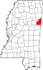 | |
| Towns | ||
| CDPs | ||
|
Unincorporated communities | ||
| Ghost towns | ||
|
| This Lowndes County, Mississippi state location article is a stub. You can help Wikipedia by expanding it. |
Wells, Mississippi | |
|---|---|
Wells Location within the state of Mississippi Wells Wells (the United States) | |
| Coordinates: 33°35′52″N 88°23′40″W / 33.59778°N 88.39444°W | |
| Country | United States |
| State | Mississippi |
| County | Lowndes |
| Elevation | 200 ft (60 m) |
| Time zone | UTC-6 ( Central (CST)) |
| • Summer ( DST) | UTC-5 (CDT) |
| Area code | 662 |
| GNIS feature ID | 679437 [1] |
Wells is an unincorporated community in Lowndes County, Mississippi. Wells is located north of Columbus. According to the United States Geological Survey, a variant name is Marx. [1]
Municipalities and communities of
Lowndes County, Mississippi, United States | ||
|---|---|---|
| City | | |
| Towns | ||
| CDPs | ||
|
Unincorporated communities | ||
| Ghost towns | ||
|
| This Lowndes County, Mississippi state location article is a stub. You can help Wikipedia by expanding it. |