| Weller River (Stream) | |
|---|---|
 Rang St-Joseph, Saint-Ubalde | |
 | |
| Location | |
| Country | Canada |
| Province | Quebec |
| Region | Capitale-Nationale, Mauricie |
| Regional County Municipality | Portneuf Regional County Municipality |
| Municipalities | Saint-Ubalde |
| Physical characteristics | |
| Source | Lac Carillon |
| • location | Saint-Ubalde, MRC Portneuf Regional County Municipality |
| • coordinates | 46°50′10″N 72°11′46″W / 46.83599°N 72.19599°W |
| • elevation | 219 m (719 ft) |
| Mouth | Blanche River |
• location | Saint-Ubalde |
• coordinates | 46°45′22″N 72°13′05″W / 46.756017°N 72.218113°W |
• elevation | 146 m (479 ft) |
| Length | 16.7 km (10.4 mi) |
| Discharge | |
| • location | Saint-Ubalde |
| Basin features | |
| Tributaries | |
| • left | (Upward from the mouth) Décharge des lacs aux Guêpes, à l'Anguille et en Coeur, décharge d'un ensemble de petits lacs. |
| • right | (Upward from the mouth) Décharge du Grand lac à Désalliers, décharge de deux lacs non identifiés. |
The Weller River (Stream) is a tributary left bank of the Blanche River (St-Casimir) whose confluence is found east of the municipality of Saint-Ubalde, in the Portneuf Regional County Municipality, in the administrative region of Capitale-Nationale, in the province of Quebec in Canada.
Forestry is the main economic activity in the upper part of this hydrographic slope; agriculture, in the lower part. [1]
Geography
The Weller River rises at Lac Carillon (length: 3.3 kilometres (2.1 mi); altitude: 219 metres (719 ft)) which straddles the boundary of the municipalities of Saint-Ubalde (Quebec) and Notre-Dame-de-Montauban. The resort developed in certain segments of the northwest and southwest shores of the lake because of Enchanted Street (north shore) and Chemin des Ballades (southwest shore). The mouth of the lake is located at the bottom of a small bay southwest of the lake.
Toponymy
The term "Weller" is a surname of German origin.
The toponym "Rivière Weller" was registered with the Place names bank of the Commission de toponymie du Québec on May 5, 1981. [2]
See also
- Blanche River (Saint-Casimir)
- Noire River (Sainte-Anne River)
- Saint-Ubalde
- Lac Sept-Îles (Saint-Ubalde)
- Portneuf Regional County Municipality
- List of rivers of Quebec
Photos
- Weller River (Stream) in St-Ubalde
-
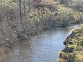
![From Steel and wood bridge P-19613,[3] rang Saint-Joseph](https://upload.wikimedia.org/wikipedia/commons/thumb/0/02/Saint_Ubalde_030.jpg/120px-Saint_Ubalde_030.jpg) From Steel and wood bridge P-19613, [3] rang Saint-Joseph
From Steel and wood bridge P-19613, [3] rang Saint-Joseph -
 From Steel and wood bridge P-19613, rang Saint-Joseph
![From Steel and wood bridge P-19613,[3] rang Saint-Joseph](/info/en/?search=File:Saint_Ubalde_030.jpg)

Notes and references
- ^ "Rivers and Lakes". Ministère de l'Environnement, de la lutte contre les changements climatiques, de la Faune et des Parcs Quebec. Government of Quebec. 2023. Retrieved 2023-11-09.
- ^ Bank of place names of Quebec (ed.). "Rivière Weller". Commission de toponymie. Retrieved January 24, 2020.
- ^ "Inventory and Inspection of Structures". Ministère des Transports et de la Mobilité durable (in French). Government of Quebec. 2023-11-01. Retrieved 2023-11-09.
Bibliography
- Sainte-Anne Development and Protection Corporation (2006). Sainte-Anne River Watershed Water Master Plan (PDF). p. 92.
External links
| Weller River (Stream) | |
|---|---|
|
Rang St-Joseph, Saint-Ubalde | |
| |
| Location | |
| Country | Canada |
| Province | Quebec |
| Region | Capitale-Nationale, Mauricie |
| Regional County Municipality | Portneuf Regional County Municipality |
| Municipalities | Saint-Ubalde |
| Physical characteristics | |
| Source | Lac Carillon |
| • location | Saint-Ubalde, MRC Portneuf Regional County Municipality |
| • coordinates | 46°50′10″N 72°11′46″W / 46.83599°N 72.19599°W |
| • elevation | 219 m (719 ft) |
| Mouth | Blanche River |
• location | Saint-Ubalde |
• coordinates | 46°45′22″N 72°13′05″W / 46.756017°N 72.218113°W |
• elevation | 146 m (479 ft) |
| Length | 16.7 km (10.4 mi) |
| Discharge | |
| • location | Saint-Ubalde |
| Basin features | |
| Tributaries | |
| • left | (Upward from the mouth) Décharge des lacs aux Guêpes, à l'Anguille et en Coeur, décharge d'un ensemble de petits lacs. |
| • right | (Upward from the mouth) Décharge du Grand lac à Désalliers, décharge de deux lacs non identifiés. |
The Weller River (Stream) is a tributary left bank of the Blanche River (St-Casimir) whose confluence is found east of the municipality of Saint-Ubalde, in the Portneuf Regional County Municipality, in the administrative region of Capitale-Nationale, in the province of Quebec in Canada.
Forestry is the main economic activity in the upper part of this hydrographic slope; agriculture, in the lower part. [1]
Geography
The Weller River rises at Lac Carillon (length: 3.3 kilometres (2.1 mi); altitude: 219 metres (719 ft)) which straddles the boundary of the municipalities of Saint-Ubalde (Quebec) and Notre-Dame-de-Montauban. The resort developed in certain segments of the northwest and southwest shores of the lake because of Enchanted Street (north shore) and Chemin des Ballades (southwest shore). The mouth of the lake is located at the bottom of a small bay southwest of the lake.
Toponymy
The term "Weller" is a surname of German origin.
The toponym "Rivière Weller" was registered with the Place names bank of the Commission de toponymie du Québec on May 5, 1981. [2]
See also
- Blanche River (Saint-Casimir)
- Noire River (Sainte-Anne River)
- Saint-Ubalde
- Lac Sept-Îles (Saint-Ubalde)
- Portneuf Regional County Municipality
- List of rivers of Quebec
Photos
- Weller River (Stream) in St-Ubalde
-
From Steel and wood bridge P-19613, [3] rang Saint-Joseph
-
From Steel and wood bridge P-19613, rang Saint-Joseph
Notes and references
- ^ "Rivers and Lakes". Ministère de l'Environnement, de la lutte contre les changements climatiques, de la Faune et des Parcs Quebec. Government of Quebec. 2023. Retrieved 2023-11-09.
- ^ Bank of place names of Quebec (ed.). "Rivière Weller". Commission de toponymie. Retrieved January 24, 2020.
- ^ "Inventory and Inspection of Structures". Ministère des Transports et de la Mobilité durable (in French). Government of Quebec. 2023-11-01. Retrieved 2023-11-09.
Bibliography
- Sainte-Anne Development and Protection Corporation (2006). Sainte-Anne River Watershed Water Master Plan (PDF). p. 92.