Photos • Location

Weed Crossroad, Alabama | |
|---|---|
 Weed Crossroad, Alabama  Weed Crossroad, Alabama | |
| Coordinates: 31°31′08″N 86°13′23″W / 31.51889°N 86.22306°W | |
| Country | United States |
| State | Alabama |
| County | Crenshaw |
| Elevation | 453 ft (138 m) |
| Time zone | UTC-6 ( Central (CST)) |
| • Summer ( DST) | UTC-5 (CDT) |
| Area code | 334 |
| GNIS feature ID | 157226 [1] |
Weed Crossroad, also known as Weed or Weedville, is an unincorporated community in Crenshaw County, Alabama, United States. It is located on Alabama State Route 141, 5.1 miles (8.2 km) south-southeast of Brantley. [2] [3] [4] [5] [6]
References
- ^ "Weed Crossroad". Geographic Names Information System. United States Geological Survey, United States Department of the Interior.
- ^ General Highway Map: Crenshaw County, Alabama (PDF) (Map). Alabama Department of Transportation. 2007. Archived from the original (PDF) on February 21, 2014. Retrieved July 30, 2015.
- ^ "Weedville Items". The Opp Weekly News. Opp, Alabama. February 19, 1931. p. 4.
- ^ "Ethel Merle Morgan". The Luverne Journal and The Crenshaw County News. Luverne, Alabama. December 1, 1937. p. 8.
- ^ "Rites Held Today For H. T. Weed, Prominent Farmer". The Luverne Journal and News. Luverne, Alabama. January 25, 1961. p. 1.
- ^ "Miss Johnson Complimented With Tea-Shower". Union Springs Herald. Union Springs, Alabama. May 12, 1977. p. 4.
Municipalities and communities of
Crenshaw County, Alabama, United States | ||
|---|---|---|
| Cities | 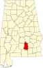 | |
| Towns | ||
|
Unincorporated communities | ||
| Footnotes | ‡This populated place also has portions in an adjacent county or counties | |
|
| This Crenshaw County, Alabama state location article is a stub. You can help Wikipedia by expanding it. |
Weed Crossroad, Alabama | |
|---|---|
Weed Crossroad, Alabama Weed Crossroad, Alabama | |
| Coordinates: 31°31′08″N 86°13′23″W / 31.51889°N 86.22306°W | |
| Country | United States |
| State | Alabama |
| County | Crenshaw |
| Elevation | 453 ft (138 m) |
| Time zone | UTC-6 ( Central (CST)) |
| • Summer ( DST) | UTC-5 (CDT) |
| Area code | 334 |
| GNIS feature ID | 157226 [1] |
Weed Crossroad, also known as Weed or Weedville, is an unincorporated community in Crenshaw County, Alabama, United States. It is located on Alabama State Route 141, 5.1 miles (8.2 km) south-southeast of Brantley. [2] [3] [4] [5] [6]
References
- ^ "Weed Crossroad". Geographic Names Information System. United States Geological Survey, United States Department of the Interior.
- ^ General Highway Map: Crenshaw County, Alabama (PDF) (Map). Alabama Department of Transportation. 2007. Archived from the original (PDF) on February 21, 2014. Retrieved July 30, 2015.
- ^ "Weedville Items". The Opp Weekly News. Opp, Alabama. February 19, 1931. p. 4.
- ^ "Ethel Merle Morgan". The Luverne Journal and The Crenshaw County News. Luverne, Alabama. December 1, 1937. p. 8.
- ^ "Rites Held Today For H. T. Weed, Prominent Farmer". The Luverne Journal and News. Luverne, Alabama. January 25, 1961. p. 1.
- ^ "Miss Johnson Complimented With Tea-Shower". Union Springs Herald. Union Springs, Alabama. May 12, 1977. p. 4.
Municipalities and communities of
Crenshaw County, Alabama, United States | ||
|---|---|---|
| Cities | | |
| Towns | ||
|
Unincorporated communities | ||
| Footnotes | ‡This populated place also has portions in an adjacent county or counties | |
|
| This Crenshaw County, Alabama state location article is a stub. You can help Wikipedia by expanding it. |