Warsaw | |
|---|---|
 | |
| Coordinates: 44°14′58″N 93°23′38″W / 44.24944°N 93.39389°W | |
| Country | United States |
| State | Minnesota |
| County | Rice County |
| Township | Warsaw Township |
| Area | |
| • Total | 1.91 sq mi (4.93 km2) |
| • Land | 0.86 sq mi (2.24 km2) |
| • Water | 1.04 sq mi (2.70 km2) |
| Elevation | 1,001 ft (305 m) |
| Population (
2020) | |
| • Total | 644 |
| • Density | 745.37/sq mi (287.89/km2) |
| Time zone | UTC-6 ( Central (CST)) |
| • Summer ( DST) | UTC-5 (CDT) |
| ZIP code | 55087 |
| Area code | 507 |
| GNIS feature ID | 653792 [2] |
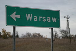
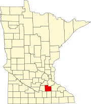
Warsaw is an unincorporated community and census-designated place (CDP) in Warsaw Township, Rice County, Minnesota, United States. As of the 2010 census, its population was 627. [3]
The community is located east of Morristown and west of Faribault.
Warsaw is located at the junction of State Highway 60 ( MN 60) and Rice County Road 13 (Farwell Avenue) on the west side of Cannon Lake.
Demographics
| Census | Pop. | Note | %± |
|---|---|---|---|
| 2020 | 644 | — | |
| U.S. Decennial Census [4] | |||
References
- ^ "2020 U.S. Gazetteer Files". United States Census Bureau. Retrieved July 24, 2022.
- ^ a b U.S. Geological Survey Geographic Names Information System: Warsaw, Minnesota
- ^ "U.S. Census website". United States Census Bureau. Retrieved May 14, 2011.
- ^ "Census of Population and Housing". Census.gov. Retrieved June 4, 2016.
- Official State of Minnesota Highway Map – 2013/2014 edition
Warsaw | |
|---|---|
 | |
| Coordinates: 44°14′58″N 93°23′38″W / 44.24944°N 93.39389°W | |
| Country | United States |
| State | Minnesota |
| County | Rice County |
| Township | Warsaw Township |
| Area | |
| • Total | 1.91 sq mi (4.93 km2) |
| • Land | 0.86 sq mi (2.24 km2) |
| • Water | 1.04 sq mi (2.70 km2) |
| Elevation | 1,001 ft (305 m) |
| Population (
2020) | |
| • Total | 644 |
| • Density | 745.37/sq mi (287.89/km2) |
| Time zone | UTC-6 ( Central (CST)) |
| • Summer ( DST) | UTC-5 (CDT) |
| ZIP code | 55087 |
| Area code | 507 |
| GNIS feature ID | 653792 [2] |
Warsaw is an unincorporated community and census-designated place (CDP) in Warsaw Township, Rice County, Minnesota, United States. As of the 2010 census, its population was 627. [3]
The community is located east of Morristown and west of Faribault.
Warsaw is located at the junction of State Highway 60 ( MN 60) and Rice County Road 13 (Farwell Avenue) on the west side of Cannon Lake.
Demographics
| Census | Pop. | Note | %± |
|---|---|---|---|
| 2020 | 644 | — | |
| U.S. Decennial Census [4] | |||
References
- ^ "2020 U.S. Gazetteer Files". United States Census Bureau. Retrieved July 24, 2022.
- ^ a b U.S. Geological Survey Geographic Names Information System: Warsaw, Minnesota
- ^ "U.S. Census website". United States Census Bureau. Retrieved May 14, 2011.
- ^ "Census of Population and Housing". Census.gov. Retrieved June 4, 2016.
- Official State of Minnesota Highway Map – 2013/2014 edition

