Photos • Location

Wahrenholz | |
|---|---|
 Coat of arms | |
Location of Wahrenholz within Gifhorn district 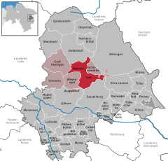 | |
 Wahrenholz  Wahrenholz | |
| Coordinates: 52°37′N 10°36′E / 52.617°N 10.600°E | |
| Country | Germany |
| State | Lower Saxony |
| District | Gifhorn |
| Municipal assoc. | Wesendorf |
| Subdivisions | 5 |
| Government | |
| • Mayor | Herbert Pieper ( CDU) |
| Area | |
| • Total | 57.99 km2 (22.39 sq mi) |
| Elevation | 55 m (180 ft) |
| Population (2022-12-31)
[1] | |
| • Total | 3,696 |
| • Density | 64/km2 (170/sq mi) |
| Time zone | UTC+01:00 ( CET) |
| • Summer ( DST) | UTC+02:00 ( CEST) |
| Postal codes | 29399 |
| Dialling codes | 05835 |
| Vehicle registration | GF |
Wahrenholz is a municipality in the district of Gifhorn, in Lower Saxony, Germany. The Municipality Wahrenholz includes the villages of Betzhorn, Teichgut, Wahrenholz, Weißenberge and Weißes Moor.
-
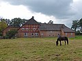 Idyll in Betzhorn
 -
 Restaurant in Teichgut
 -
 The Lutheran church in Wahrenholz
 -
 Water mill in Wahrenholz


| International | |
|---|---|
| National | |
| Geographic | |
|
| This Gifhorn district location article is a stub. You can help Wikipedia by expanding it. |
Wahrenholz | |
|---|---|
|
Coat of arms | |
Location of Wahrenholz within Gifhorn district | |
Wahrenholz Wahrenholz | |
| Coordinates: 52°37′N 10°36′E / 52.617°N 10.600°E | |
| Country | Germany |
| State | Lower Saxony |
| District | Gifhorn |
| Municipal assoc. | Wesendorf |
| Subdivisions | 5 |
| Government | |
| • Mayor | Herbert Pieper ( CDU) |
| Area | |
| • Total | 57.99 km2 (22.39 sq mi) |
| Elevation | 55 m (180 ft) |
| Population (2022-12-31)
[1] | |
| • Total | 3,696 |
| • Density | 64/km2 (170/sq mi) |
| Time zone | UTC+01:00 ( CET) |
| • Summer ( DST) | UTC+02:00 ( CEST) |
| Postal codes | 29399 |
| Dialling codes | 05835 |
| Vehicle registration | GF |
Wahrenholz is a municipality in the district of Gifhorn, in Lower Saxony, Germany. The Municipality Wahrenholz includes the villages of Betzhorn, Teichgut, Wahrenholz, Weißenberge and Weißes Moor.
-
Idyll in Betzhorn
-
Restaurant in Teichgut
-
The Lutheran church in Wahrenholz
-
Water mill in Wahrenholz
| International | |
|---|---|
| National | |
| Geographic | |
|
| This Gifhorn district location article is a stub. You can help Wikipedia by expanding it. |