Photos • Location

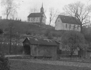
The Wadestown Covered Bridge.

The Wadestown Covered Bridge was a single-lane wooden covered bridge in Wadestown, Monongalia County, West Virginia, United States. It spanned the Virginia (later West Virginia) branch of Dunkard Creek. It was still standing in 1941 when the Work Projects Administration surveyed the state. [1] It was in use into the 1950s.
- ^ Writers' Program of the WPA (1941), West Virginia, a Guide to the Mountain State, Compiled by the Workers of the Writers' Program of the Work Projects Administration in the State of West Virginia; Conservation Commission of West Virginia.
Categories:
- Buildings and structures in Monongalia County, West Virginia
- Covered bridges in West Virginia
- Road bridges in West Virginia
- Transportation in Monongalia County, West Virginia
- Wooden bridges in West Virginia
- Southern United States bridge (structure) stubs
- West Virginia building and structure stubs
- West Virginia transportation stubs