Vincentown, New Jersey | |
|---|---|
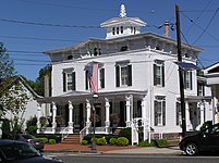
.JPG) Historic houses on Plum Street | |
 Vincentown Location in
Burlington County  Vincentown Location in
New Jersey  Vincentown Location in the United States | |
| Coordinates: 39°56′02″N 74°44′55″W / 39.93389°N 74.74861°W | |
| Country | |
| State | |
| County | Burlington |
| Township | Southampton |
| Named for | Vincent Leeds |
| Area | |
| • Total | 0.59 sq mi (1.52 km2) |
| • Land | 0.54 sq mi (1.41 km2) |
| • Water | 0.04 sq mi (0.11 km2) |
| Elevation | 39 ft (12 m) |
| Population | |
| • Total | 535 |
| • Density | 985.27/sq mi (380.50/km2) |
| Time zone | UTC−05:00 ( Eastern (EST)) |
| • Summer ( DST) | UTC−04:00 ( Eastern (EDT)) |
| ZIP Code | 08088
[4] |
| Area code(s) | 609, 640 |
| FIPS code | 34-76040 [5] |
| GNIS feature ID | 881465
[2] 2806213 [6] |
Vincentown is an unincorporated community and census-designated place (CDP) [7] located on the South Branch Rancocas Creek in Southampton Township of Burlington County, New Jersey. [6] [8] The area is served as United States Postal Service ZIP Code 08088. [4]
As of the 2010 United States Census, the population for ZIP Code Tabulation Area 08088 was 24,664. [9]
Demographics
| Census | Pop. | Note | %± |
|---|---|---|---|
| 2020 | 535 | — | |
| U.S. Decennial Census [10] [3] | |||
History
In 1743, Vincent Leeds purchased the land where the community is now built. It was later named after him, Vincent's Town. Previously, the village had been known as Brimstone Neck. [11]
Historic district
Vincentown Historic District | |
.JPG) John Woolston House | |
| Location | Roughly bounded by Mill, Church, Pleasant, Main, and Race Streets, and Red Lion Road |
|---|---|
| Area | 92 acres (37 ha) |
| Architectural style | Greek Revival, Late Victorian, Federal |
| NRHP reference No. | 87002107 [12] |
| NJRHP No. | 870 [13] |
| Significant dates | |
| Added to NRHP | September 21, 1988 |
| Designated NJRHP | April 16, 1987 |
The Vincentown Historic District is a 92-acre (37 ha) historic district roughly bounded by Mill, Church, Pleasant, Main, and Race Streets, and Red Lion Road encompassing the community. It was added to the National Register of Historic Places on September 21, 1988 for its significance in architecture, commerce, industry, religion, and social history. The district includes 160 contributing buildings and 3 contributing sites. [14] The John Woolston House, a 2+1⁄2-story brick house with Federal style, was previously documented by the Historic American Buildings Survey in 1938. [15] The house at 57 Main Street is a three-story Italianate style house featuring a cupola with a tree-type finial. It was built c. 1865 and is a key contributing property. [14]
-
 Italianate house at 57 Main Street
.JPG)
Transportation
Red Lion Airport is located in Vincentown. [16]
Points of interest
- The Pinelands Preservation Alliance has its headquarters and visitor center at the Bishop–Irick Farmstead, which is listed on the NRHP. [17]
- DeMastro Vineyards
Notable people
People who were born in, residents of, or otherwise closely associated with Vincentown include:
- Samuel A. Dobbins (1814–1886), represented New Jersey's 2nd congressional district in the United States House of Representatives from 1873–1877. [18]
- Brad Ecklund (1922–2010), center who played five seasons in the NFL. [19]
- Job H. Lippincott (1842–1900), United States Attorney for the District of New Jersey and Associate Justice of the New Jersey Supreme Court. [20]
- Chauncey Morehouse (1902–1980), jazz drummer. [21]
- Jim Saxton (born 1943), Congressman from 1984 to 2009. [22] [23]
- Beulah Woolston (1828–1886), pioneering missionary teacher in China.
See also
References
- ^ "ArcGIS REST Services Directory". United States Census Bureau. Retrieved October 11, 2022.
- ^ a b "Vincentown". Geographic Names Information System. United States Geological Survey, United States Department of the Interior. Variant names: Vincent's Town, Brimstone Neck
- ^ a b "Census Population API". United States Census Bureau. Retrieved October 11, 2022.
- ^ a b Zip Codes, State of New Jersey. Accessed December 1, 2013.
- ^ Geographic Codes Lookup for New Jersey, Missouri Census Data Center. Accessed June 9, 2023.
- ^ a b "Vincentown Census Designated Place". Geographic Names Information System. United States Geological Survey, United States Department of the Interior.
- ^ State of New Jersey Census Designated Places - BVP20 - Data as of January 1, 2020, United States Census Bureau. Accessed December 1, 2022.
- ^ Locality Search, State of New Jersey. Accessed June 9, 2016.
- ^ DP-1 - Profile of General Population and Housing Characteristics: 2010 from the 2010 Demographic Profile Data for ZCTA5 08088, United States Census Bureau. Accessed July 18, 2016.
- ^ "Census of Population and Housing". Census.gov. Retrieved June 4, 2016.
- ^ "Historic Vincentown". Southampton Township, New Jersey.
- ^ "National Register Information System – (#87002107)". National Register of Historic Places. National Park Service. November 2, 2013.
- ^ "New Jersey and National Registers of Historic Places – Burlington County" (PDF). New Jersey Department of Environmental Protection - Historic Preservation Office. September 28, 2021. p. 16.
- ^ a b Bolger, William C. (December 1983). "National Register of Historic Places Inventory/Nomination: Vincentown Historic District". National Park Service. With accompanying 60 photos
- ^ "John Woolston House, 51-53 Mill Street, Vincentown". Historic American Buildings Survey. 1938.
- ^ Red Lion Airport (N73), New Jersey Department of Transportation. Accessed June 9, 2016.
- ^ "PPA Headquarters and Visitors Center". Pinelands Preservation Alliance. March 27, 2018.
- ^ Samuel Atkinson Dobbins, Biographical Directory of the United States Congress. Accessed August 15, 2007.
- ^ Vargas, Claudia. "Brad Ecklund, former NFL player, coach", The Philadelphia Inquirer, February 10, 2010. Accessed February 28, 2011. "Brad Ecklund, 87, of Vincentown, a former NCAA and NFL football player who coached the Eagles' offensive line in the 1970s, died Saturday of congestive heart failure at Samaritan Hospice in Mount Holly."
- ^ Fitzgerald, Thomas F. Manual of the Legislature of New Jersey 1900, p. 291. T. F. Fitzgerald, 1900. Accessed July 18, 2016. "Job H. Lippincott, Jersey City. Justice Lippincott was born near Mount Holly, N.J., November 12th, 1842. He was reared on his father's farm at Vincentown, N.J., and received a common-school education."
- ^ "Chauncey Morehosue, 78, jazz drummer", The Philadelphia Inquirer, November 4, 1980. Accessed June 7, 2020. "Chauncey Morehouse, 78, a jazz drummer, died Friday at a nursing home in Medford, N.J. He formerly lived in Vincentown, N.J."
- ^ Stout, David. "New Jersey Daily Briefing; A Deal for Lockheed Martin", The New York Times, May 8, 1995. Accessed June 2, 2017. "Lockheed Martin's government electronic systems plant has been awarded a $35 million contract for engineering and technical work on Japanese naval destroyers, Representative Jim Saxton, Republican of Vincentown, announced last week."
- ^ Barone, Michael; and Ujifusa, Grant. The Almanac of American Politics 1988', p. 764. National Journal, 1987.
External links
-
 Media related to
Vincentown, New Jersey at Wikimedia Commons
Media related to
Vincentown, New Jersey at Wikimedia Commons - Historic American Buildings Survey (HABS) No. NJ-494, " John Woolston House, 51-53 Mill Street, Vincentown, Burlington County, NJ", 4 photos, 29 measured drawings, 3 data pages, supplemental material
- Vincent Fire Company
- Preservation Commission of Historic Southampton

| International | |
|---|---|
| National | |
Vincentown, New Jersey | |
|---|---|
|
Historic houses on Plum Street | |
Vincentown Location in
Burlington County Vincentown Location in
New Jersey Vincentown Location in the United States | |
| Coordinates: 39°56′02″N 74°44′55″W / 39.93389°N 74.74861°W | |
| Country | |
| State | |
| County | Burlington |
| Township | Southampton |
| Named for | Vincent Leeds |
| Area | |
| • Total | 0.59 sq mi (1.52 km2) |
| • Land | 0.54 sq mi (1.41 km2) |
| • Water | 0.04 sq mi (0.11 km2) |
| Elevation | 39 ft (12 m) |
| Population | |
| • Total | 535 |
| • Density | 985.27/sq mi (380.50/km2) |
| Time zone | UTC−05:00 ( Eastern (EST)) |
| • Summer ( DST) | UTC−04:00 ( Eastern (EDT)) |
| ZIP Code | 08088
[4] |
| Area code(s) | 609, 640 |
| FIPS code | 34-76040 [5] |
| GNIS feature ID | 881465
[2] 2806213 [6] |
Vincentown is an unincorporated community and census-designated place (CDP) [7] located on the South Branch Rancocas Creek in Southampton Township of Burlington County, New Jersey. [6] [8] The area is served as United States Postal Service ZIP Code 08088. [4]
As of the 2010 United States Census, the population for ZIP Code Tabulation Area 08088 was 24,664. [9]
Demographics
| Census | Pop. | Note | %± |
|---|---|---|---|
| 2020 | 535 | — | |
| U.S. Decennial Census [10] [3] | |||
History
In 1743, Vincent Leeds purchased the land where the community is now built. It was later named after him, Vincent's Town. Previously, the village had been known as Brimstone Neck. [11]
Historic district
Vincentown Historic District | |
|
John Woolston House | |
| Location | Roughly bounded by Mill, Church, Pleasant, Main, and Race Streets, and Red Lion Road |
|---|---|
| Area | 92 acres (37 ha) |
| Architectural style | Greek Revival, Late Victorian, Federal |
| NRHP reference No. | 87002107 [12] |
| NJRHP No. | 870 [13] |
| Significant dates | |
| Added to NRHP | September 21, 1988 |
| Designated NJRHP | April 16, 1987 |
The Vincentown Historic District is a 92-acre (37 ha) historic district roughly bounded by Mill, Church, Pleasant, Main, and Race Streets, and Red Lion Road encompassing the community. It was added to the National Register of Historic Places on September 21, 1988 for its significance in architecture, commerce, industry, religion, and social history. The district includes 160 contributing buildings and 3 contributing sites. [14] The John Woolston House, a 2+1⁄2-story brick house with Federal style, was previously documented by the Historic American Buildings Survey in 1938. [15] The house at 57 Main Street is a three-story Italianate style house featuring a cupola with a tree-type finial. It was built c. 1865 and is a key contributing property. [14]
-
Italianate house at 57 Main Street
Transportation
Red Lion Airport is located in Vincentown. [16]
Points of interest
- The Pinelands Preservation Alliance has its headquarters and visitor center at the Bishop–Irick Farmstead, which is listed on the NRHP. [17]
- DeMastro Vineyards
Notable people
People who were born in, residents of, or otherwise closely associated with Vincentown include:
- Samuel A. Dobbins (1814–1886), represented New Jersey's 2nd congressional district in the United States House of Representatives from 1873–1877. [18]
- Brad Ecklund (1922–2010), center who played five seasons in the NFL. [19]
- Job H. Lippincott (1842–1900), United States Attorney for the District of New Jersey and Associate Justice of the New Jersey Supreme Court. [20]
- Chauncey Morehouse (1902–1980), jazz drummer. [21]
- Jim Saxton (born 1943), Congressman from 1984 to 2009. [22] [23]
- Beulah Woolston (1828–1886), pioneering missionary teacher in China.
See also
References
- ^ "ArcGIS REST Services Directory". United States Census Bureau. Retrieved October 11, 2022.
- ^ a b "Vincentown". Geographic Names Information System. United States Geological Survey, United States Department of the Interior. Variant names: Vincent's Town, Brimstone Neck
- ^ a b "Census Population API". United States Census Bureau. Retrieved October 11, 2022.
- ^ a b Zip Codes, State of New Jersey. Accessed December 1, 2013.
- ^ Geographic Codes Lookup for New Jersey, Missouri Census Data Center. Accessed June 9, 2023.
- ^ a b "Vincentown Census Designated Place". Geographic Names Information System. United States Geological Survey, United States Department of the Interior.
- ^ State of New Jersey Census Designated Places - BVP20 - Data as of January 1, 2020, United States Census Bureau. Accessed December 1, 2022.
- ^ Locality Search, State of New Jersey. Accessed June 9, 2016.
- ^ DP-1 - Profile of General Population and Housing Characteristics: 2010 from the 2010 Demographic Profile Data for ZCTA5 08088, United States Census Bureau. Accessed July 18, 2016.
- ^ "Census of Population and Housing". Census.gov. Retrieved June 4, 2016.
- ^ "Historic Vincentown". Southampton Township, New Jersey.
- ^ "National Register Information System – (#87002107)". National Register of Historic Places. National Park Service. November 2, 2013.
- ^ "New Jersey and National Registers of Historic Places – Burlington County" (PDF). New Jersey Department of Environmental Protection - Historic Preservation Office. September 28, 2021. p. 16.
- ^ a b Bolger, William C. (December 1983). "National Register of Historic Places Inventory/Nomination: Vincentown Historic District". National Park Service. With accompanying 60 photos
- ^ "John Woolston House, 51-53 Mill Street, Vincentown". Historic American Buildings Survey. 1938.
- ^ Red Lion Airport (N73), New Jersey Department of Transportation. Accessed June 9, 2016.
- ^ "PPA Headquarters and Visitors Center". Pinelands Preservation Alliance. March 27, 2018.
- ^ Samuel Atkinson Dobbins, Biographical Directory of the United States Congress. Accessed August 15, 2007.
- ^ Vargas, Claudia. "Brad Ecklund, former NFL player, coach", The Philadelphia Inquirer, February 10, 2010. Accessed February 28, 2011. "Brad Ecklund, 87, of Vincentown, a former NCAA and NFL football player who coached the Eagles' offensive line in the 1970s, died Saturday of congestive heart failure at Samaritan Hospice in Mount Holly."
- ^ Fitzgerald, Thomas F. Manual of the Legislature of New Jersey 1900, p. 291. T. F. Fitzgerald, 1900. Accessed July 18, 2016. "Job H. Lippincott, Jersey City. Justice Lippincott was born near Mount Holly, N.J., November 12th, 1842. He was reared on his father's farm at Vincentown, N.J., and received a common-school education."
- ^ "Chauncey Morehosue, 78, jazz drummer", The Philadelphia Inquirer, November 4, 1980. Accessed June 7, 2020. "Chauncey Morehouse, 78, a jazz drummer, died Friday at a nursing home in Medford, N.J. He formerly lived in Vincentown, N.J."
- ^ Stout, David. "New Jersey Daily Briefing; A Deal for Lockheed Martin", The New York Times, May 8, 1995. Accessed June 2, 2017. "Lockheed Martin's government electronic systems plant has been awarded a $35 million contract for engineering and technical work on Japanese naval destroyers, Representative Jim Saxton, Republican of Vincentown, announced last week."
- ^ Barone, Michael; and Ujifusa, Grant. The Almanac of American Politics 1988', p. 764. National Journal, 1987.
External links
-
Media related to
Vincentown, New Jersey at Wikimedia Commons
- Historic American Buildings Survey (HABS) No. NJ-494, " John Woolston House, 51-53 Mill Street, Vincentown, Burlington County, NJ", 4 photos, 29 measured drawings, 3 data pages, supplemental material
- Vincent Fire Company
- Preservation Commission of Historic Southampton
| International | |
|---|---|
| National | |