| Vert | |
|---|---|
 | |
| Location | |
| Country | France |
| Physical characteristics | |
| Source | |
| • location | Barétous |
| Mouth | |
• location | Gave d'Oloron |
• coordinates | 43°13′15″N 0°39′16″W / 43.22083°N 0.65444°W |
| Length | 35 km (22 mi) |
| Basin features | |
| Progression | Gave d'Oloron→ Gaves réunis→ Adour→ Atlantic Ocean |
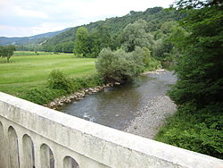
The Vert, is a left tributary of the Gave d'Oloron, that drains the Barétous in the High- Béarn ( Pyrénées-Atlantiques), in the Southwest of France. It flows into the Gave d'Oloron in Moumour, downstream from Oloron-Sainte-Marie. It is 35.0 km (21.7 mi) long. [1]
Vert means 'green' in French, but the river name, Bert in 1467, is related to the Gascon word barta that means ' floodplain'.
The Vert is formed in Aramits from the confluence of:
- (R) the Vert d' Arette, Larron in 1589, from the Chousse Plateau, below the Pic de Guillers, elevation 1,597 metres (5,240 ft),
- (L) the Vert de Barlanès, from Issarbe and Lanne-en-Barétous.
References
| Vert | |
|---|---|
 | |
| Location | |
| Country | France |
| Physical characteristics | |
| Source | |
| • location | Barétous |
| Mouth | |
• location | Gave d'Oloron |
• coordinates | 43°13′15″N 0°39′16″W / 43.22083°N 0.65444°W |
| Length | 35 km (22 mi) |
| Basin features | |
| Progression | Gave d'Oloron→ Gaves réunis→ Adour→ Atlantic Ocean |
The Vert, is a left tributary of the Gave d'Oloron, that drains the Barétous in the High- Béarn ( Pyrénées-Atlantiques), in the Southwest of France. It flows into the Gave d'Oloron in Moumour, downstream from Oloron-Sainte-Marie. It is 35.0 km (21.7 mi) long. [1]
Vert means 'green' in French, but the river name, Bert in 1467, is related to the Gascon word barta that means ' floodplain'.
The Vert is formed in Aramits from the confluence of:
- (R) the Vert d' Arette, Larron in 1589, from the Chousse Plateau, below the Pic de Guillers, elevation 1,597 metres (5,240 ft),
- (L) the Vert de Barlanès, from Issarbe and Lanne-en-Barétous.
References

