Venator, Oregon | |
|---|---|
 Venator  Venator | |
| Coordinates: 43°20′53″N 118°18′19″W / 43.34806°N 118.30528°W | |
| Country | United States |
| State | Oregon |
| County | Harney |
| Elevation | 3,766 ft (1,148 m) |
| Time zone | UTC-8 ( Pacific) |
| • Summer ( DST) | UTC-7 (Pacific) |
| Area code | 541 |
| Coordinates and elevation from United States Geological Survey [1] | |
Venator is an unincorporated community in Harney County, Oregon, United States. [1] It is on Crane–Venator Road about 17 miles (27 km) southeast of Crane, near the South Fork Malheur River. [2]
Alphena Venator, a native of Linn County, settled in Harney County as a youth in 1872. [3] [4] Alphena's father Jezreel is the namesake for Venator Canyon in Harney and Malheur counties. [3] [4] When Alphena established a livestock ranch in the area in 1884, the locale soon became known as "Venator". [3] Venator post office was established in 1895, with Louella Venator as the first postmaster. [3] The office was later moved two and a half miles north to a station on the now-abandoned Oregon Eastern Branch (or Burns Branch) of the Union Pacific railroad. [3] [5] As of 1976, there were only six buildings and a corral at the site, although at one time there was a Civilian Conservation Corps (CCC) camp in the area.
Venator is in Harney County School District 4 (Crane School, grades K-8) and Harney County Union High School District 1J ( Crane Union High School). [6] [7]
- ^ a b "Venator". Geographic Names Information System. United States Geological Survey, United States Department of the Interior. November 28, 1980. Retrieved January 3, 2016.
- ^ Oregon Atlas & Gazetteer (7th ed.). Yarmouth, Maine: DeLorme. 2008. p. 82. ISBN 0-89933-347-8.
- ^ a b c d e McArthur, Lewis A.; McArthur, Lewis L. (2003) [1928]. Oregon Geographic Names (7th ed.). Portland, Oregon: Oregon Historical Society Press. p. 991. ISBN 978-0875952772.
- ^ a b Simpson, Peter K. (1987). The Community of Cattlemen: A Social History of the Cattle Industry in Southeastern Oregon, 1869-1912. University of Idaho Press. p. 132. ISBN 978-0893011178.
- ^ Schwieterman, Joseph P. (2004). When the Railroad Leaves Town: American Communities in the Age of Rail Line Abandonment, Western United States. Kirksville, Missouri: Truman State University Press. p. 228. ISBN 978-1-931112-13-0.
-
^
"2020 CENSUS - SCHOOL DISTRICT REFERENCE MAP: Harney County, OR" (PDF).
U.S. Census Bureau. p. 1(PDF p. 2/3). Retrieved March 11, 2024.
Crane-Venator Rd
- Text list - Compare to the highway map. - ^ "Harney County Sheet 6 of 11" (PDF). Oregon Department of Transportation. Retrieved March 11, 2024. - Venator indicated on the map. Compare with school district map.
- History of the Oregon Eastern Branch from Abandonedrails.com
- History of the Burns Branch from High Desert Rails
Municipalities and communities of
Harney County, Oregon, United States | ||
|---|---|---|
| Cities | 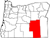 | |
| CDP | ||
|
Other communities | ||
| Indian reservation | ||
| Ghost towns | ||
| Desert | ||
|
| This Harney County, Oregon state location article is a stub. You can help Wikipedia by expanding it. |
Venator, Oregon | |
|---|---|
Venator Venator | |
| Coordinates: 43°20′53″N 118°18′19″W / 43.34806°N 118.30528°W | |
| Country | United States |
| State | Oregon |
| County | Harney |
| Elevation | 3,766 ft (1,148 m) |
| Time zone | UTC-8 ( Pacific) |
| • Summer ( DST) | UTC-7 (Pacific) |
| Area code | 541 |
| Coordinates and elevation from United States Geological Survey [1] | |
Venator is an unincorporated community in Harney County, Oregon, United States. [1] It is on Crane–Venator Road about 17 miles (27 km) southeast of Crane, near the South Fork Malheur River. [2]
Alphena Venator, a native of Linn County, settled in Harney County as a youth in 1872. [3] [4] Alphena's father Jezreel is the namesake for Venator Canyon in Harney and Malheur counties. [3] [4] When Alphena established a livestock ranch in the area in 1884, the locale soon became known as "Venator". [3] Venator post office was established in 1895, with Louella Venator as the first postmaster. [3] The office was later moved two and a half miles north to a station on the now-abandoned Oregon Eastern Branch (or Burns Branch) of the Union Pacific railroad. [3] [5] As of 1976, there were only six buildings and a corral at the site, although at one time there was a Civilian Conservation Corps (CCC) camp in the area.
Venator is in Harney County School District 4 (Crane School, grades K-8) and Harney County Union High School District 1J ( Crane Union High School). [6] [7]
- ^ a b "Venator". Geographic Names Information System. United States Geological Survey, United States Department of the Interior. November 28, 1980. Retrieved January 3, 2016.
- ^ Oregon Atlas & Gazetteer (7th ed.). Yarmouth, Maine: DeLorme. 2008. p. 82. ISBN 0-89933-347-8.
- ^ a b c d e McArthur, Lewis A.; McArthur, Lewis L. (2003) [1928]. Oregon Geographic Names (7th ed.). Portland, Oregon: Oregon Historical Society Press. p. 991. ISBN 978-0875952772.
- ^ a b Simpson, Peter K. (1987). The Community of Cattlemen: A Social History of the Cattle Industry in Southeastern Oregon, 1869-1912. University of Idaho Press. p. 132. ISBN 978-0893011178.
- ^ Schwieterman, Joseph P. (2004). When the Railroad Leaves Town: American Communities in the Age of Rail Line Abandonment, Western United States. Kirksville, Missouri: Truman State University Press. p. 228. ISBN 978-1-931112-13-0.
-
^
"2020 CENSUS - SCHOOL DISTRICT REFERENCE MAP: Harney County, OR" (PDF).
U.S. Census Bureau. p. 1(PDF p. 2/3). Retrieved March 11, 2024.
Crane-Venator Rd
- Text list - Compare to the highway map. - ^ "Harney County Sheet 6 of 11" (PDF). Oregon Department of Transportation. Retrieved March 11, 2024. - Venator indicated on the map. Compare with school district map.
- History of the Oregon Eastern Branch from Abandonedrails.com
- History of the Burns Branch from High Desert Rails
Municipalities and communities of
Harney County, Oregon, United States | ||
|---|---|---|
| Cities | | |
| CDP | ||
|
Other communities | ||
| Indian reservation | ||
| Ghost towns | ||
| Desert | ||
|
| This Harney County, Oregon state location article is a stub. You can help Wikipedia by expanding it. |