Photos • Location

Velp | |
|---|---|
Town | |
 360° Panorama, Main Street, Velp, The Netherlands. | |
 Velp Location in the province of Gelderland in the Netherlands  Velp Velp (Netherlands) | |
| Coordinates: 51°59′41″N 5°58′33″E / 51.99472°N 5.97583°E | |
| Country | Netherlands |
| Province | Gelderland |
| Municipality | Rheden |
| Area | |
| • Total | 11.02 km2 (4.25 sq mi) |
| Elevation | 18 m (59 ft) |
| Population (2021)
[1] | |
| • Total | 18,100 |
| • Density | 1,600/km2 (4,300/sq mi) |
| Time zone | UTC+1 ( CET) |
| • Summer ( DST) | UTC+2 ( CEST) |
| Postal code | 6881-6883
[1] |
| Dialing code | 026 |
| Major roads | A12 |
Velp is a Dutch village located east of Arnhem within the municipality of Rheden, between Arnhem, Rozendaal, and the town of Rheden.
Velp was a separate municipality from 1812 to 1818, when it was merged with Rheden. The municipality also included the village of Rozendaal. [3]
-
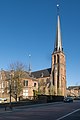 Church: Onze Lieve Vrouw Visitatiekerk
 -
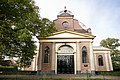 New Church, built 1841
 -
 Palace "het Biljoen"
 -
 Monumental office building on the Hoofdstraat
 -
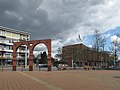 Street view (de Hoofdstraat)
 -
 River IJssel near Velp
 -
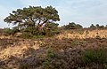 Veluwe near Velp, tree in the field at the Driesprong


- Jan Goossens, former American indoor soccer player.
- Ho-Pin Tung, auto-racing driver
- René Klaassen, former field hockey defender
- Mina Kruseman, 19th-century feminist and author
- Ella van Heemstra, aristocrat and mother of Audrey Hepburn [4]
- Audrey Hepburn, 20th-century actress and humanitarian [5]
- ^ a b c "Kerncijfers wijken en buurten 2021". Central Bureau of Statistics. Retrieved 14 April 2022.
- ^ "Postcodetool for 6881AA". Actueel Hoogtebestand Nederland (in Dutch). Het Waterschapshuis. 24 July 2019. Retrieved 14 April 2022.
- ^ Ad van der Meer and Onno Boonstra, Repertorium van Nederlandse gemeenten, KNAW, 2011.
- ^ "'Those Are Things You Don't Forget.' How a Young Audrey Hepburn Helped the Dutch Resistance During World War II". 3 May 2019.
- ^ "'Those Are Things You Don't Forget.' How a Young Audrey Hepburn Helped the Dutch Resistance During World War II". 3 May 2019.
-
 Media related to
Velp, Gelderland at Wikimedia Commons
Media related to
Velp, Gelderland at Wikimedia Commons
| International | |
|---|---|
| National | |
| Geographic | |
|
| This Gelderland location article is a stub. You can help Wikipedia by expanding it. |
Velp | |
|---|---|
Town | |
|
360° Panorama, Main Street, Velp, The Netherlands. | |
Velp Location in the province of Gelderland in the Netherlands Velp Velp (Netherlands) | |
| Coordinates: 51°59′41″N 5°58′33″E / 51.99472°N 5.97583°E | |
| Country | Netherlands |
| Province | Gelderland |
| Municipality | Rheden |
| Area | |
| • Total | 11.02 km2 (4.25 sq mi) |
| Elevation | 18 m (59 ft) |
| Population (2021)
[1] | |
| • Total | 18,100 |
| • Density | 1,600/km2 (4,300/sq mi) |
| Time zone | UTC+1 ( CET) |
| • Summer ( DST) | UTC+2 ( CEST) |
| Postal code | 6881-6883
[1] |
| Dialing code | 026 |
| Major roads | A12 |
Velp is a Dutch village located east of Arnhem within the municipality of Rheden, between Arnhem, Rozendaal, and the town of Rheden.
Velp was a separate municipality from 1812 to 1818, when it was merged with Rheden. The municipality also included the village of Rozendaal. [3]
-
Church: Onze Lieve Vrouw Visitatiekerk
-
New Church, built 1841
-
Palace "het Biljoen"
-
Monumental office building on the Hoofdstraat
-
Street view (de Hoofdstraat)
-
River IJssel near Velp
-
Veluwe near Velp, tree in the field at the Driesprong
- Jan Goossens, former American indoor soccer player.
- Ho-Pin Tung, auto-racing driver
- René Klaassen, former field hockey defender
- Mina Kruseman, 19th-century feminist and author
- Ella van Heemstra, aristocrat and mother of Audrey Hepburn [4]
- Audrey Hepburn, 20th-century actress and humanitarian [5]
- ^ a b c "Kerncijfers wijken en buurten 2021". Central Bureau of Statistics. Retrieved 14 April 2022.
- ^ "Postcodetool for 6881AA". Actueel Hoogtebestand Nederland (in Dutch). Het Waterschapshuis. 24 July 2019. Retrieved 14 April 2022.
- ^ Ad van der Meer and Onno Boonstra, Repertorium van Nederlandse gemeenten, KNAW, 2011.
- ^ "'Those Are Things You Don't Forget.' How a Young Audrey Hepburn Helped the Dutch Resistance During World War II". 3 May 2019.
- ^ "'Those Are Things You Don't Forget.' How a Young Audrey Hepburn Helped the Dutch Resistance During World War II". 3 May 2019.
-
Media related to
Velp, Gelderland at Wikimedia Commons
| International | |
|---|---|
| National | |
| Geographic | |
|
| This Gelderland location article is a stub. You can help Wikipedia by expanding it. |