Ushi
Ուշի | |
|---|---|
 The village of Ushi. Smoke rises as villagers burn dead plant material during the fall season. | |
 Ushi  Ushi | |
| Coordinates: 40°20′54″N 44°22′23″E / 40.34833°N 44.37306°E | |
| Country | Armenia |
| Province | Aragatsotn |
| Municipality | Ashtarak |
| Elevation | 1,400 m (4,600 ft) |
| Population (2008) | |
| • Total | 1,386 |
| Time zone | UTC+4 |
| • Summer ( DST) | UTC+5 |
Ushi ( Armenian: Ուշի) is a village in the Ashtarak Municipality of the Aragatsotn Province of Armenia. It contains a 10th-century chapel, and approximately 1 km outside the village are the ruins of Saint Sargis Monastery of the 7th to 13th centuries. Under the Chapel of Saint Sargis (the only structure still standing), is the grave and re-interred remains of the aforementioned saint. On top of the hill adjacent to the monastery complex are the collapsed remains of an Iron Age fortress.
Gallery
-
 Ruins of the Saint Sargis monastic complex of the 7th to 13th centuries at Ushi
 -
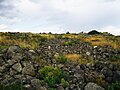 Iron Age fortress of Ushi


References
- Ushi, Armenia at GEOnet Names Server
- World Gazetteer: Armenia[ dead link] – World-Gazetteer.com
- Report of the results of the 2001 Armenian Census, Statistical Committee of Armenia
- Lilit Hovhannisyan (2009-02-06). "Thirsting for a Mate: Tradition and faith meet on St. Sarkis Day". Features. ArmeniaNow.com. Retrieved 2013-06-14.

|
| This article about a location in Aragatsotn Province, Armenia is a stub. You can help Wikipedia by expanding it. |
Ushi
Ուշի | |
|---|---|
|
The village of Ushi. Smoke rises as villagers burn dead plant material during the fall season. | |
Ushi Ushi | |
| Coordinates: 40°20′54″N 44°22′23″E / 40.34833°N 44.37306°E | |
| Country | Armenia |
| Province | Aragatsotn |
| Municipality | Ashtarak |
| Elevation | 1,400 m (4,600 ft) |
| Population (2008) | |
| • Total | 1,386 |
| Time zone | UTC+4 |
| • Summer ( DST) | UTC+5 |
Ushi ( Armenian: Ուշի) is a village in the Ashtarak Municipality of the Aragatsotn Province of Armenia. It contains a 10th-century chapel, and approximately 1 km outside the village are the ruins of Saint Sargis Monastery of the 7th to 13th centuries. Under the Chapel of Saint Sargis (the only structure still standing), is the grave and re-interred remains of the aforementioned saint. On top of the hill adjacent to the monastery complex are the collapsed remains of an Iron Age fortress.
Gallery
-
Ruins of the Saint Sargis monastic complex of the 7th to 13th centuries at Ushi
-
Iron Age fortress of Ushi
References
- Ushi, Armenia at GEOnet Names Server
- World Gazetteer: Armenia[ dead link] – World-Gazetteer.com
- Report of the results of the 2001 Armenian Census, Statistical Committee of Armenia
- Lilit Hovhannisyan (2009-02-06). "Thirsting for a Mate: Tradition and faith meet on St. Sarkis Day". Features. ArmeniaNow.com. Retrieved 2013-06-14.
|
| This article about a location in Aragatsotn Province, Armenia is a stub. You can help Wikipedia by expanding it. |