|
User talk:MapMaster/Archive01
User talk:MapMaster/Archive02 |
Great job on the maps. They are very accurate and illustrating. Thanks again! Omegastar ( talk) 13:36, 24 February 2008 (UTC)
If you want a translation for one of your maps, in French, German, or Arabic, contact me, I would love to help you! --Escondites talk 12:06, 28 December 2006 (UTC)
Could you please do a translation of this map in Arabic? I can translate the names but wouldn't know how to edit it. Thanks a lot. -- Aa2-2004 ( talk) 16:00, 15 December 2010 (UTC)
Thanks!! Good work as usual. I was in my sea house in the Christmas days, so sorry for late reply. Well, my grandaunt has an Italian old encyclopedia with a VERY detailed map of Italian states during the Middle Ages (the best one is truly a puzzle with even the minorest seignories, it's stunning - it is about around 13th-14th centuries however). I'll provide you, if you want, as soon as I'll be able to scan it. Bye and thanks again. -- Attilios 11:34, 3 January 2007 (UTC)
Thank you for the skill and care you are putting into these goodlooking maps. They enrich every article in which they appear. -- Wetman 12:47, 9 January 2007 (UTC)
Hello MapMaster,
On your userpage you stated that you are open to map requests. If it's possible, I'd like to request a map of the Habsburg Monarchy from 1713-1740. There are a few maps around showing Austria-Hungary but none of the monachy before that time. It would greatly enhance an artikel dealing with that subject. I hope you'd like to help me with it.
Regards, nl:Gebruiker:Sir Iain 213.10.202.180 21:56, 9 July 2007 (UTC)
Your maps are beutiful, informative, indicate hours of hard work, and show expertise in conveying information visually. I just had to give you this:

|
The Barnstar of Diligence | |
| For creating beautiful and informative maps with attention to detail, quality, and practical value. Fishal 20:56, 7 September 2007 (UTC) |
- Wow, I am speechless. Thank you very much. I love doing this work here and in particular adding some non-text information and snazz to Wikipedia. The work is not all that hard, but yes I do try hard to be precise. For that, I have to thank all the many folks (indeed, experts) who've written back with corrections, suggestions, and information for me.
- Quite a boost!! Thanks again!
MapMaster 03:45, 8 September 2007 (UTC)
- You're welcome! I had just encountered some of them at Byzantine Empire, took a look at the others on your user page, and realized you needed another one. They are definitely a notch or two better than any other maps I've seen on Wikipedia. Fishal 16:05, 8 September 2007 (UTC)
Thanks for the tips, I'll fix it in a bit. :)
- Now, what's your next map?? MapMaster 03:44, 25 September 2007 (UTC)
I've been looking for info to replace raster Map of Ontario with an SVG one. I've found some places with clear data but they're always copyrighted. I thought about tracing the current map, but it isn't detailed enough. Do you have any suggestions on how I can find that info? Vidioman 10:58, 25 September 2007 (UTC)
- Since I'm lurking here I'll go ahead and answer. You're going to run into that problem a lot as almost everything for Canada is copyrighted, but if you're talking about this map (which really does need to be replaced as it's a rather obvious copyright violation) then I think everything you need is available provided you have GIS software to import it into. Province borders, cities, rivers, and lakes can all be gotten from DCW, Great Lakes boundaries can be gotten from there too, but you might get a better layer from the National Atlas. The background relief can be gotten from USGS, I can probably hook you up with that if you want it as I already have relief for North America downloaded and pre-processed for my own use. Kmusser 13:21, 25 September 2007 (UTC)
I don't have GIS software. I was referring to the black white and red locater maps, but if the relief map should be re-done, I'll try it in the future. I'll take a look at those places. As for the Thunder Bay map, I don't think a locater thumb map is necessary. The Thunder Bay article already has a locater (which I want to replace), and the other page it's on is related to the Thunder Bay article. I have another version I am tweaking for the articles about highways in the area, however, and that map would have a thumb map, once I have made it. (for Ontario) Vidioman 14:56, 25 September 2007 (UTC) Ok, I took a look at DCW, and I think the map is 'squished'? (I had this problem with another source I found the other day). The projection it uses isn't appropriate for an Ontario map. Vidioman 14:58, 25 September 2007 (UTC)
- Ah, for that you should be able to take one of the existing maps from the commons and make locater maps out of it. Kmusser 15:05, 25 September 2007 (UTC)
It doesn't have outlines of the census divisions, however. Aside from city locaters, I was going to make CD and region locaters (Park locaters, etc.). Where would I get that data? Vidioman 15:08, 25 September 2007 (UTC)
- You can't, at least not legally, census division boundaries are copyrighted by Statistics Canada, though I suppose you could trace them off a paper map that was older than 50 years. Kmusser 15:32, 25 September 2007 (UTC)
There is no map of CDs older than 50 years, they were redrawn less than a decade ago. But if that's so, then aren't all of the Ontario maps violating a copyright? Vidioman 15:53, 25 September 2007 (UTC)
- Yes, unless someone got permission from StatsCan, which I doubt but might be possible. Kmusser 16:49, 25 September 2007 (UTC)
By CD I mean the districts, regional and single tier municipalities and counties of Ontario. I don't see how StatsCan could hold a copyright on that? [1] Vidioman 17:13, 25 September 2007 (UTC)
![[1]](/info/en/?search=Image:Ontariocensusdivisions.PNG)
- They don't for the others, just for the Census Divisions, which usually follow municipal and county boundaries, but not always (and technically it's for their maps of the boundaries, not the boundaries themselves, but since they're the only source . . .). I don't know of another source for administrative boundaries - and anything produced by any Canadian government agency is still going to be copyrighted (they each have their own terms though and some might be loose enough to allow use on wikipedia), also if you found a U.S. government produced map showing Canadian administrative boundaries that would be legal, but I've never seen one. Kmusser 17:55, 25 September 2007 (UTC)
Would it be possible to use the written descriptions (these are usually posted on elections Canada websites) which describe, in detail, the path the boundary takes, and then use that? It would be extremely time consuming but possible. You could also ask Earl Andrew where he got the data in the first place. Vidioman 18:07, 25 September 2007 (UTC) Also, census divisions ARE county boundaries. Census division is the blanket term for all districts, counties, regions, single-tiered municipalities, etc., in Canada. The level of division immediately below Provincial and Territorial is a Census Division. Vidioman 18:09, 25 September 2007 (UTC)
- Using written descriptions would definitely be ok (though tedious), Earl Andrew and Qyd's maps are both from StatsCan maps and thus probably not legal, I'm not about to spend a bunch of time playing policeman though. Kmusser 18:29, 25 September 2007 (UTC)
Ok.. I created a map on Ontario by modifying Canada geolocalisation, BUT, going through the licensing, I noticed that Canada geolocalisation came from Carte administrative du Canada.svg, which came from Carte administrative du Canada.png, which came from this government website. So, wouldn't that mean that, by default, this is a violation of copyright? this map is from the same source. Vidioman 17:18, 26 September 2007 (UTC)
- Atlas of Canada stuff is copyrighted, but
this map, while using the Atlas of Canada as a reference, does not look like a direct copy of their map, so it might be ok. How much tracing stuff off another map constitutes a violation is a legal grey area - the derivatives especially are different enough from the original that they're probably ok. The
relief map, on the other hand, is a direct copy (and still has the original copyright notice on it even).
Kmusser 18:09, 26 September 2007 (UTC)
- does not look like a direct copy of their map, so it might be ok.
If you look at both of them superimposed, ( image) not only does it become almost impossible to tell them apart, but you can clearly see that the grey used for international territory is identical. The map of Ontario's divisions ( image) superimposed on it's source (Environment Canada's GeoSearch2006) shows it not only had to be scaled up considerable but is also fairly inaccurate, and looking at their copyright information, ( source) it appears that it would be OK to use it here, so long as the link to StatsCan's website is included with mention that that is the source of the image's data. Vidioman 12:52, 27 September 2007 (UTC)
- Vidioman, I really don't see a problem with using the graphic data (e.g. boundaries) on a copyrighted map to create your own map. The copyright applies to the way the data is presented and not the data itself. As long as your new map is not a direct copy of the copyrighted map, as long as you're not trying to make money off the new map, I just don't see a problem developing. To keep from making an exact copy, do not show exactly the same area, do not use the same colours, and do not copy the copyrighted map by mechanical means. By adding your own design decisions, I firmly believe you will be making a new work (of art!!). Hope this helps, MapMaster 13:05, 27 September 2007 (UTC)
- Well Wikipedia is a commercial use, otherwise we could use the StatCan stuff directly, but anyway, yeah, as long as yours isn't a direct copy and you cite your sources you should be fine. Also if you want you could ask StatCan permission, for all I know they might be happy to grant it, I've never asked. Kmusser 14:11, 27 September 2007 (UTC)
I created
this. I traced the boundaries from
Image:Ontario subdivisions.PNG but because of the low resolution (of both maps) the borders are really jagged and approximate. I wanted to avoid that, but it would be too hard to do so.
Vidioman 01:49, 28 September 2007 (UTC)
I re-did the map, tracing things and building it like I did the Thunder Bay map, instead of the weird fractured way the original was made. (
new map)
Vidioman 18:13, 28 September 2007 (UTC)
Hello there - you don't know me, I think, but I stumbled across your name at a MilHist peer review as a possible good source for maps. I've recently uploaded this map: Image:Gebora_and_1_Badajoz.jpg, but I'm concerned that it's very borderline for copyright purposes. Therefore, if you're still active, aren't too busy, and feel inclined, would it be OK for me to humbly, on bended knee, request an equivalent from your good self? I've tried to use InkScape myself to make maps, but my artistic skills are frankly non-existent! Thanks very much if you can help out... hell, thanks very much even if you can't! Carre 18:10, 31 October 2007 (UTC)
- I'd love to. This may take me a couple of weeks since I promised to work on a Muslim history map first. I myself like miliary history and would welcome the opportunity. I was very disappointed to find that the most recent military history Featured Article (forget the name -- it was concerning a 19th century battle on the Afghan frontier) did not have a single good map. What's up with that, anyway?!?!? Thanks,
MapMaster 21:23, 6 November 2007 (UTC)
- That's wonderful! I've written a few 19th century MilHist articles, including an FA (
Battle of Barrosa), and finding maps that aren't in copyright is very difficult for that time period. Unfortunately, contributors with your map making skills are few and far between, and most of us aren't even aware of your existence (writing Barrosa, I had a comment that it needed a map and it took me weeks to find a PD one I could use). The couple of weeks time scale isn't a problem for me, since I need to get the relevant article (
Battle of the Gebora) through LoCE, GA review and MilHist A-class review before I take it to FAC... but it will be there eventually, and hopefully with your map adorning it!
Carre 21:34, 6 November 2007 (UTC)
- Hello again. Yes, your suggestion sounds good to me. 350px shouldn't be a problem (I may have to shift the image of Mortier to make room for the larger size), and colours would certainly be nice . I'm afraid I don't know the scale on that version of the map. Look forward to seeing your work in the article!
Carre 10:26, 9 November 2007 (UTC)
- That's a great map, and I can't really criticise it at all! The colours are fine for the Spanish troops, so no problems there. The boundary you've chosen means that a couple of the outlying forts around Badajoz are dropped off, but that doesn't matter too much for this article. When I get to the 1st (and 2nd, for that matter) sieges of Badajoz, I will probably be able to find a more detailed map of the fortress that you could possibly use then to complete it. (Most military maps of Badajoz are concerned with 3rd Badajoz siege, so no use for 1st or 2nd). Elvas and Campo Maior are really too far away from the area of the map to include, so not fitting those in is fine too.
- By campaign map, do you mean a kind of higher level one, showing the important places (such as Elvas etc)? Something showing the lines of march for both the Spanish and the French? That sort of thing would fit in well in Prelude to battle, I agree (I used one for Battle of Barrosa), but I don't have anything to use as an original source. Of course, if you can come up with one with nothing to work from, it'd fit in very nicely.
- Anyway, I love the new map, so thanks very much for putting in the effort! Carre 08:59, 13 November 2007 (UTC)
- Hello again. Yes, your suggestion sounds good to me. 350px shouldn't be a problem (I may have to shift the image of Mortier to make room for the larger size), and colours would certainly be nice . I'm afraid I don't know the scale on that version of the map. Look forward to seeing your work in the article!
Carre 10:26, 9 November 2007 (UTC)
- That's wonderful! I've written a few 19th century MilHist articles, including an FA (
Battle of Barrosa), and finding maps that aren't in copyright is very difficult for that time period. Unfortunately, contributors with your map making skills are few and far between, and most of us aren't even aware of your existence (writing Barrosa, I had a comment that it needed a map and it took me weeks to find a PD one I could use). The couple of weeks time scale isn't a problem for me, since I need to get the relevant article (
Battle of the Gebora) through LoCE, GA review and MilHist A-class review before I take it to FAC... but it will be there eventually, and hopefully with your map adorning it!
Carre 21:34, 6 November 2007 (UTC)
I have considered using standards. I tried the one at en:Wikiproject:Maps, I found it too garish. I tried the fr:Wikipedia colours, and they were a bit too dull for my tastes, though I do prefer them. My main problem with the fr:Wikipedia standard is that when viewed greyscale, the shades for land and water are too similar. Taking into account the colour blind and LCD monitors which tend to have a "washed out" display, and my design is much more appropriate in terms of accessibility.
Additionally, those maps don't account for certain things maps might be used for. There is no option for roads, which some of my maps require. When pointing out different cities and requiring different colours to do so, the "standard" colours were, in my opinion, to garish for the job, and lacked a darker colour for border areas. so I created my own standards for that as well.
The colours I chose came after about a week of browsing maps on both the French and English Wikipedias (I'm a member at both though not very active at the French one) and finding averages, or seeing what other people has used, as well as consulting traditional paper maps to see how various professionals have dealt with the issues of dealing with displaying their information. The colours for borders and territories are based on various maps displayed on en:Wikiproject:Maps and the French standard, as are colours for water bodies, roads, and primary selections. Parks (which I also use as secondary selections as I like that particular shade of green) is based on the old colour for infoboxes of National parks. The yellow and purple are my own choice, I decided on those colours after browsing other maps and seeing which colours were used when displaying many colours and ensuring that they wouldn't be similar in grey scale or close enough to cause confusion. The topographic map scale is from the various topographic maps posted on the French Wikipedia, unaltered though I left the scale with single digit numbers so that I could alter it to suit my own needs. (That is an old version of the map, I don't have a raster of the current one.) The subway map colours were created for a project outside of Wikipedia entirely, I simply needed a more organized way to access the colours. I went through a couple dozen different mass transit maps 'harvesting' colours and trying to find the best ones. Those colours can also be used on future maps, if needed.
Most of my interests in map making are in small scale urban maps, ( a work in progress) so I have created colours to help me with that, and will expand the colour list in the future.
Simply put: I don't think the colours chosen for the "standard" are good enough, and I have chosen my own colours, but I have also taken the standard into consideration and tried to stay as close to it as possible while also satisfying my own perfectionist desires. To be honest, I find those Ontario maps hideous (That resolution is shit for an SVG map, the shores lines are much too jagged) and should I ever come across free data that I can actually use I will replace all of those maps. The hockey team maps will also be replaced when I find that source, and I am currently working on a cleaner version of the Thunder Bay map, which will be versatile and can be used in multiple articles. I have continuously postponed articles relating to local expressways.
I think I've covered everything? :P vıdıoman ( talk • contribs) 02:39, 22 November 2007 (UTC)
Tricky map request: Covering of the Senne
OK, I think this might be fairly tricky, but I'll ask anyways. Can you superimpose a map of the former route of the Senne river on a map of the modern downtown or that of 1887, such that the Central Halls would be visible? Please also include the Brussels Stock Exchange and Greater and Lesser sluice gates, and the Central Halls... if possible, the Brussels Stock Exchange being the most important. I think all the base maps you would need either are already in the article covering of the Senne, or are linked to at the bottom. I don't really mind whether the new things are superimposed on the old, or the old superimposed on the new.
Sorry that request wasn't really that coherent, but I was trying to get out a lot of stuff at once. Let me know what you think or if you need any help at all, and if you'll be able to do it. Thanks! - Oreo Priest 16:15, 22 November 2007 (UTC)
- Also, because the maps in the article are in the public domain, you wouldn't really have to start from scratch if you don't want to.- Oreo Priest 16:17, 22 November 2007 (UTC)
I would be interested in trying to make a map for this article. I am always up for a challenge. Let me do some research this weekend and then get back to you with some ideas.
Thanks for thinking of me, MapMaster ( talk) 03:54, 30 November 2007 (UTC)
- I just realized now that it would also be nice if you were able to do a French version to place on the corresponding article on their WP, from which the English one comes. Would that be OK? - Oreo Priest 09:37, 30 November 2007 (UTC)
Please include:
- The series of boulevards consisting of Hainaut Boulevard (now Maurice Lemonnier Boulevard), Central Boulevard (now Anspach Boulevard), North Boulevard (now Adolphe Max Boulevard) and Senne Boulevard (now Émile Jacqmain Boulevard)
- The Greater and Lesser sluice gates' locations can be inferred from where the Senne entered the pentagon, it may not be necessary to include them
- The Stock Exchange
- The Halles Centrales (Central Halls), visible on the 1883 map at the bottom of the page
- Place De Brouckere for sure and perhaps Place Rogier
- Maybe the former fountain at place De Brouckere
- The Augustinian convent, which was in between the two branches of the "Y"
- The modern (post 1955) course of the Senne, under the left half of the Small Ring, I think that should be clear enough.
- Maybe the fr:Palais du Midi
- Maybe the north and south railway stations to provide context
Please remember to use a neutral language in labelling; either English or BOTH French and Dutch, this sort of thing is very sensitive in Belgium. For the French map, if you choose to do one, just French will do. Thanks a bunch, and keep the questions coming! - Oreo Priest 10:54, 2 December 2007 (UTC)
- That map in its basic form is good, though you're right it lacks wow factor. (Which doesn't really bother me.) One issue I have is that I think the Senne is a bit too far to the northwest. While map here is obviously low quality, the course of the Senne corresponds roughly to the official maps I've seen. Also, the small ring was strictly within the bend of the canal at the top left. Also, please include The modern (post 1955) course of the Senne, under the left half of the Small Ring, and Adolphe Max Boulevard as part of the "Y". Thanks, Oreo Priest 10:19, 6 December 2007 (UTC)
- That map is great! All three of your suggestions would definitely be good to implement. I think widening the Senne would be a good start, as I think on that scale that the line is actually thinner than the river itself. If you're looking for wow factor, maybe also change the colour of the background... perhaps to a light yellow... that may zest it up (although the suggestion is purely stylistic). Look forward to hearing from you again! - Oreo Priest 05:36, 6 January 2008 (UTC)
- The streets in the upper town (bottom right) you added are not really as useful as the ones in the lower town (top left). At any rate, the most useful streets to add would be those mentioned in the article, especially Adolphe Max Boulevard, the right hand part of the "Y".
- The 1883 map linked to at the bottom of the article has most of what I requested, mostly along the central boulevards. The Stadhuis is not really relevant to the context of the article. More or less everything else in the checklist above is there, but only the Stock Exchange and the Halles Centrales [and the modern course of the Senne] are really important; you can choose to include or reject everything else based on what you think would look best. Thanks! - Oreo Priest 12:28, 8 January 2008 (UTC)
Getting close
Beautiful!! I think it's almost ready. I do, however have a handful of nitpicky changes that should be made:
- Bourse and Halles Centrales MUST be either a calque (Stock Exchange and Central Halls) or bilingual French/Dutch, as this sort of thing is very sensitive. I like the way you put only the names of the central boulevards and not rue ... straat, it's much tidier that way.
- I'm pretty sure the 1837 (not 1833) course of the Senne is what's superimposed
- I think there should be an arrow pointing towards Bourse like there is to the Halles Centrales for clarity
- I think the Halles Centrales should be labelled as demolished 1958 to avoid confusion
- I think you should delete all of the street names that aren't the central boulevards (Lemonnier, Anspach, Adolphe Max, Jacqmain); they aren't mentioned in the article and I think they detract from the focus a bit in addition to their two-languaged names (unlike the central boulevards) creating another thorny linguistic issue
- Similarly, I think you should delete the Stadhuis; it isn't really relevant, distracts, and would need to be calqued or bilingual
- Could you please label the Lesser Senne (the wobbly bit outside of the pentagon) and/or the Charleroi Canal (the straight section in the top left just outside the pentagon) and/or the modern course of the Senne which is under the left arm of the pentagon? I doubt you'll be able to do all of them so I'll leave it to your judgement what to do
- It would be nice if you could say Senne (Zenne) or Senne/Zenne instead of just Senne, again for neutrality, but if this doesn't work stylistically, don't worry about it too much
Sorry for being so picky and thanks a million! I can almost taste it it's so close... In fact, I've already put it in the article. - Oreo Priest 21:34, 15 January 2008 (UTC)
- All of that is ok. You're the experienced cartographer after all. Re-add the Stadhuis (as Town Hall) then. As for the peripheral streets, try to remove Schlachthuis, replacing it with Poincaré, solely for ease of rendering. Niewpoort is ok now that I think about it, but change Lakense to Laeken (only per name of the article in WP).
- Neither of the two stations would be visible on the map, but they would be good to include. The only way I can see this being done (which shows where they are anyways) is putting an arrow pointing south along Lemmonier (to South Station) and one north along Adolphe Max (to North Station). I hope I explained that clearly enough... I'm sure you'll think of something.
- To be honest, now that I think about it, I'm not sure enough about exactly where the Senne goes now to indicate it on the map. It's in the prose and the readers should be able to infer it.
- Once you're done the English map, I'll just write up a list of what needs to be substituted for French and Dutch versions. Thanks. - Oreo Priest 11:21, 16 January 2008 (UTC)
- And as for the edit summary "Wordsmithing", take a look at
this for a laugh. -
Oreo Priest 11:37, 16 January 2008 (UTC)
- How's this: "He wanted to attract the middle class, most of whom had left the dingy downtown for the cleaner suburbs, including the Leopold quarter (now often called the European quarter) and Louise Avenue, causing a large loss in tax revenue for the city."
- As for Antwerp gate: The reason it's there is before I had your map, I needed some frame of reference to explain where the river left the city. It is located where Laeken meets the pentagon. It is mostly a historic name because it used to be a gate to the city through its old walls; a standalone gate only existed for less than 20 years (one of them being 1837), being destroyed in 1838. There still is an Antwerp gate, but it's just a name given to an intersection. I don't know how good your French is, but the fr:wp has a good article on it: fr:Porte d'Anvers. In short, you can include the building or the intersection if you want, but the main reason it was mentioned at all was to help with localization before there was a good map. - Oreo Priest 15:13, 16 January 2008 (UTC)
Yes we are
She's a beauty! I think that does it! I'll let you know when I have the French and Dutch translation requests ready, which shouldn't be too long. Well done! - Oreo Priest 18:46, 16 January 2008 (UTC)
Other Langages
To save space, I'm going to write EN:FR:NL for each caption which needs to be changed. What I haven't listed does not need to be changed.
- Yellow box:Parcours urbain de la Senne en 1837 [br] en surimpression sur la actuelle ville de Bruxelles:De Zenne [br] Loop in 1837 [br] Getekend doorheen hedendaags Brussel-stad
- Lesser Senne:Petite Senne:Kleine Zenne
- Charleroi Canal:Canal Charleroi:Kanaal Brussel-Willebroek
- Nieuwpoort:Nieuport:Nieuwpoort
- Laeken:Laeken:Laken
- Antwerp Gate:Porte d'Anvers:Antwerpsepoort
- Augustinian Church, demolished 1893:Église des Augustins (démolie en 1893):Augustijnenkerk (afgebroken in 1893)
- Central Halls (demolished 1958):Halles Centrales (démolies en 1958):Centrale Hallen (afgebroken in 1958)
- Stock Exchange:Bourse:Beurs
- South Station:Gare du Midi:Zuidstation
- North Station:Gare du Nord:Noordstation
- I would remove the scale in yards, as the unit is only used by English speakers
- I would name the files voutement de la Senne and overwelving van de Zenne or some variant, but this is merely a suggestion
I think that should be enough. Any questions, let me know, and let me know where I can find them when they're done. Thanks! - Oreo Priest 12:46, 17 January 2008 (UTC)
- Good job adding the French map. Apparently I made a few translation errors, as pointed out by the original writer of the article. Here they are verbatim (If you don't understand the French, just let me know).
- Merci beaucoup pour la version française du plan. [I've since told him it was your work] Il y aurait cependant quelques corrections à demander au graphiste:
- dans le cadre: remplacer en surimpression sur la actuelle Ville de Brussels par: en surimpression sur le plan actuel de la Ville de Bruxelles (meilleure formulation et nom de la ville en français)
- dans le plan: remplacer Antoine Daesaert par :Antoine Dansaert, Canal Charleroi par Canal de Charleroi et Artevelde par Van Artevelde (puisque il s'agit du nom d'une personne, Jacob Van Artevelde)
- Thanks,
Oreo Priest 13:50, 31 January 2008 (UTC)
- I have made the changes suggested on the French map and I also changed the street names on the English map.
- Could you go to the French map and write a description in French? That would help, I think. MapMaster ( talk) 23:55, 31 January 2008 (UTC)
Good article
So the article just passed its GA nomination, and your map was a big help. I think I might shoot the moon and try to get the article to FA, but I also might not. Thanks again for the wonderful map! - Oreo Priest 17:50, 20 January 2008 (UTC)
Hi MapMaster,
Just a quick note to let you know the Battle of the Gebora article got to FA with no problems, so if you're into userboxes, I guess you deserve this:
|
| This user helped promote Battle of the Gebora to featured article status. |
The wonderful map you made for the article helped immensely :) Carre ( talk) 14:02, 9 December 2007 (UTC)
Why is it claimed that this shield boss is Gallo-Roman and from 400 AD?? This artifact is located at the Metropolitan Museum in New York City, and its I-Net site states that its a Longobardic Shield Boss from the 7th Cen. AD northern italy. http://www.metmuseum.org/toah/ho/06/eust/ho_1984.184.1,2.htm Daufer
- It is exactly the same image as that photo which you have uploaded. Wandalstouring ( talk) 16:55, 29 January 2008 (UTC)
- I went back and checked my notes and I have an actual photo of the display card with the "Gallo-Roman" stuff that I wrote. However, I do see that the Met webpage says that this shield is Lombard/Langobard. I ended up researching the 400 AD Vermand treasure and I found the following description of the shield boss found in that trove:
- "The umbo, or shield boss, has a tall, sharply pointed cone set on a circular rim decorated with four round paste cabochons imitating chalcedony". in their Bulletin
- That certainly does not describe this shield boss. So I can only suppose that the display card I photographed referred to another shield boss also in the case. I have uploaded a new version: Image:Langobard Shield Boss 7th Century.jpg. I will substitute this for the misnamed one when the Usage link works.

This seems overdue. - Oreo Priest 11:03, 1 February 2008 (UTC)
- Well, this is a wonderful surprise. Thank you very much for this. I love making maps and wish I could spend more time doing it. This certainly was a challenging one, trying to overlay data from two century-old maps with modern data.
- Keep up the good work there, Oreo, and I would love to work with you on another project. MapMaster ( talk) 17:07, 4 February 2008 (UTC)
MapMaster, thank you very much for taking the time to make a map for Dahlak Archipelago! I found the article after watching a PBS documentary related to it, and was disappointed to find no map - and I'm surprised (and delighted) that my request didn't take long to be fulfilled.
If you don't mind me asking, how did you make the map? (If you explained this before to someone else, feel free to link me to that discussion.)
Again, thanks a lot! -- Iamunknown 06:46, 13 February 2008 (UTC)
- Hehe, I just noticed on your user page that you mention you generally use Inkscape (I hope you'll forgive me for jumping the gun and asking you anyways :). Do you load a rasterised map and use it as a reference? Again, thanks. Feel free to answer (or not answer) my questions - and sorry for all of them! I'm just excited right now. :) -- Iamunknown 06:50, 13 February 2008 (UTC)
Thank you very much for the map at Seljuk Sultanate of Rûm. That article has needed a legible map for quite some time. I do not wish to appear ungrateful but would you be able to make some minor adjustments? The Black Sea port of Sinop was not yet part of Seljuk territory in 1190; the conquest of Sinop in 1214 followed the acquisition of Antalya on the Mediterranean in 1207. In short, there was no time when the Seljuks possessed a port on the Black Sea without a port on the Mediterranean. Furthermore the eastern extension did not happen until the 1220s and 1230s. The most useful map would represent Seljuk territory at the death of its greatest ruler Kayqubad the Great in 1236. I have found some reasonably accurate maps online: Encyclopaedia Britannica and Eron Coins (click on “Seljuqs of Rum” below the coin). Once again, thank you for making a map for the Seljuks of Rum. I love your work and can recognize it instantly. Regards, Aramgar ( talk) 14:26, 15 February 2008 (UTC)
- Thank you for your kind words. Based on its listing at Category:Former country articles requiring a map, I saw that the Seljuk Sultanate of Rûm article, and similar articles in other languages, needed a locator map, so I put one together.
- I was very happy to make the adjustment for Sinop, which I have now uploaded. If this is still not correct, let me know.
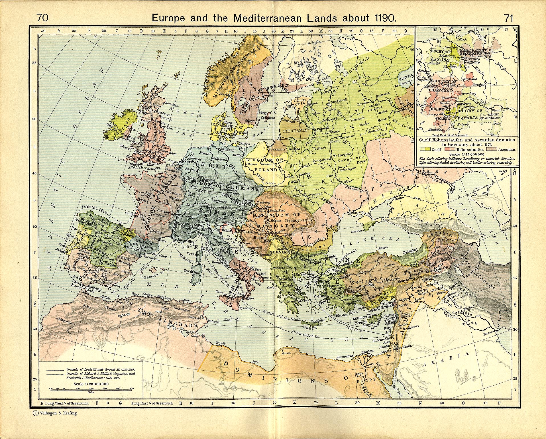
- Regarding the eastern territories, I used William Shepherd's 1911 "Map of Europe and the Meditteraean Lands about 1190". If you have additional or conflicting information, I could review and incorporate that into my map.
- I could also look into making a 1236 map, if you felt that was desirable.
- Thanks for your own work here at Wikipedia! Sincerely, MapMaster ( talk) 23:24, 15 February 2008 (UTC)
- Thank you for the modifications to [Image:Seljuk Sultanate of Rum 1190 Locator Map.svg]. If you have time for such in the coming weeks, I believe a locator-style map reflecting the Seljuk Sultanate of Rûm at the time of the death of Kayqubad I would be an excellent addition to Wikipedia. The two links above are accurate. Thank you again. Regards, Aramgar ( talk) 18:34, 19 February 2008 (UTC)
| English: | Polski (Polish): |
|---|---|
| Baltic Tribes | Ludy Bałtyjskie |
| c. 1200 N.E. | ok. 1200 n.e. |
| Baltic Sea | Morze Bałtyckie |
| Gulf of Riga | Zatoka Ryska |
| Lake Peipus | Jezioro Pejpus |
| Livonians | Liwowie |
| Latgalians | Łatgalowie |
| selonians | Zelowie |
| Semigallians | Zemgalowie |
| curonians | Kurowie |
| Lithuanians | Litwini |
| aukstatians | Auksztoci |
| Highland Lithuanians | dont write |
| samogitians | Żmudzini |
| Lowland Lithuanians | dont write |
| Daugava | Dźwina |
| berezina | Berezyna |
| Neris | Wilia |
| nemunas (neman) | Niemen |
| Yotvingas | Jaćwingowie |
| (sudovians) | (Sudowie) |
| narew | Narew |
| Bug | Bug |
| vistula | Wisła |
| poles | Polacy |
| Galindians | Galindowie |
| skalvians | Skalowowie |
| sambians | Sambowie |
| nadruvians | Nadrowowie |
| Bartians | Bartowie |
| Prussians | Prusowie |
| Warmians | Warmowie |
| Nantongius | Natangowie |
| Pogesanians | Pogezanowie |
| Pomesanians | Pomezanowie |
| kilometres | kilometry |
| miles | mile |
| English: | Polski (Polish): |
|---|---|
| Sultanate of Rum | Sułtanat Ikonium |
| Principality of Armenian Cilicia | Księstwo Małej Armenii |
| County of Edessa | Hrabstwo Edessy |
| Principality of Antioch | Księstwo Antiochii |
| Byzantine Empire | Cesarstwo Bizantyjskie |
| County of Tripoli | Hrabstwo Trypolisu |
| Kingdom of Jeruzalem | Królestwo Jerozolimskie |
| Ascalon | Askalon |
| Acre | Akka |
| Emirate of Damascus | Państwa Seldżuków |
| Euphrathes | Eufrat |
| Mediterrean Sea | Morze Śródziemne |
| Assasins | Asasyni |
| Near East | Bliski Wschód |
| Fatimid Kalifate of Cairo | kalifat Fatymidów |
| kilometres | kilometry |
| miles | mile |
| betwen the firs and second crusade | pomiędzy pierwszą a drugą krucjatą |
| Tarsus | Tars |
| Sis | sis |
| Konya | Konya |
| Harran | Harran |
| Aleppo | Aleppo |
- Greetings. MapMaster, please excuse my orthographic mistakes in English. I translate to Polish words from this map, two words you dont need write, like lowland and higlands lithuanians. In polish we always only use names Żmudzini (samogitians) and Auksztoci (aukstatians). In few days i send you rest of translations on Polish, from your maps.
- About your polish wiki user page- i want write translate, but Roo72 been faster ;p.
- About crusades map:Just translate your map to polish without look for this pl:Grafika:Panstwakrzyz.png, i dont know why i write city names ;p. thanks.
You're do a great job with this maps.
Killroyus|
Talk 11:33, 16 February 2008 (UTC) and 12:00, 16 February 2008 (UTC)
- Hello, sorry for silence from my side. I readed your messages today. Thanks for translated into polish Image:Panstwakrzyz 1135 PL.svg. I insert it into other articles.
Image-Panstwakrzyz.png (my unperfect translate) will be deleted. —Preceding Killroyus| Talk 15:48, 29 February 2008 (UTC)
- Hey, i made a mistake in name -one of those countries- Fatimid Kalifate of Cairo. In Polish must be Kalifat Fatymidów not like now- kalifat Fatymindów Killroyus| Talk 17:19, 20 March 2008 (UTC)
I come to notice and thank you, the article Battle of the Gebora is the today feature article of the english wikipedia, your Gebora's battle maps is really great in this article and have probably help the article to be nominated. 210.203.61.15 ( talk) 14:08, 19 February 2008 (UTC)
- Thank you for your kind words. The battle map was fun to make. MapMaster ( talk) 21:10, 19 February 2008 (UTC)
Hello, I just wanted to let you know that apparently there was a mistake in Image:Baltic Tribes c 1200.svg (Curonians should have been colored in green). So I fixed it, and while at it I tweaked some other colors. I also updated Lithuanian and Latvian versions of the map. Hope you are ok with that. Renata ( talk) 16:59, 23 February 2008 (UTC)
- Renata3, the fix to the Baltic tribes map is fine with me. From what little information I saw this morning, yes, the Curonians were a West Baltic tribe and should be colored green. Thanks for the help, MapMaster ( talk) 14:28, 24 February 2008 (UTC)
Thank you for the beautiful maps!
I would like to make a suggestion - a number of the cities that have "Babylon in the time of Hammurabi" maps were actually players in the previous millenium, i.e. the time of Sumer and Akkad. Could you make a map for this time period?
Is there any way to use a terrain background for the maps?
Sumerophile ( talk) 18:58, 4 March 2008 (UTC)
- Thanks for your kind words.
- I would be happy to make a map of the Sumer and Akkad time period. Let me see what references and sources I can find. Is there anything you had in mind??
- Regarding the terrain background, I have never done this except with terrain elevation lines such as in the map of the Battle of the Gebora. I know that commons:user:Sting is quite successful at this, but I've never inquired as to his technique. Is there any particular feature you would like me to emphasize?? Regards, MapMaster ( talk) 16:18, 5 March 2008 (UTC)
- Well the cities are listed on the Sumer page, and the articles have their coords. ( Mari, Syria and Nagar, Syria are outside the core area and could probably just have arrows pointing off the map.)
- Terrain maps are just my personal choice, like on the map on Sumer, or Google Maps [2], or Sting's maps as you mentioned. I do find it informative to see the geography of an area, because it shapes borders, trade routes, etc. But I don't know if there are terrain backgrounds available that are not copyrighted in some way.
- Sumerophile ( talk) 20:28, 5 March 2008 (UTC)
- Some more thoughts: Elam, Sumer's neighbor to the east, should be shown as well, as there was a lot of contact (often war) between the two groups. Susa is near Sumer's core area, but Anshan (Persia) might be shown with an arrow.
- The Elamite city Awan has not been located, but is thought to be near Sumer's core area as well. A few Sumerian cities have not been located either, but there are guesses for their general vicinity - I'm not sure how (if) that would be designated on a map. Sumerophile ( talk) 00:40, 7 March 2008 (UTC)
I finished a crude map on the initial troop movement and battles here. Wandalstouring ( talk) 10:17, 18 March 2008 (UTC)
- Thanks, Wandal! I enjoy maps like this. Let me queue this up behind a map of Bengal languages (see my Commons talk page). MapMaster ( talk) 20:21, 18 March 2008 (UTC)

Hey here- http://commons.wikimedia.org/wiki/Image:Baltic_Tribes_c_1200PL..svg you've a translated by me into polish, your map-Balts. I know u had a very much work, so i read wikibooks about Inkscape and do it self. Thanks. Ps. this is my first time with Inkscape so please, look for technical mistakes. Killroyus| Zagadaj 14:05, 24 March 2008 (UTC)
- Good job, Killroyus. Sorry I was so tardy that you had to step in. MapMaster ( talk) 16:49, 6 April 2008 (UTC)
Hi Mapmaster. I've seen your excellent work at Seljuk Sultanate of Rûm, among other places, and was hoping you might be able to help us at Mongol raids into Palestine. The concerns editors have with the current maps can be found on the talk page. Would you be willing to apply your expertise to the problem? Thanks, Kafka Liz ( talk) 10:00, 10 April 2008 (UTC)
- Well, yes, I would love to add/replace maps for the Mongol raids into Palestine. I am a bit backed up right now, Liz, and my non-Wikipedia life has become a bit busy but I hope to be able to address this in a week or so. Is that soon enough?? Thanks, MapMaster ( talk) 00:53, 15 April 2008 (UTC)
I intent to make a series (preferably 3) of maps for the Second Punic War. The request is here. Greetings Wandalstouring ( talk) 08:00, 27 April 2008 (UTC)

Could you please use a map that goes as far east as Pergamon so with one basic map I can show all troop movements of the war. Thanks Wandalstouring ( talk) 04:52, 30 April 2008 (UTC)
- I want maps of the whole war (I suggest 3 maps that fit nicely with the structure of the article), not a map showing only some of Hannibal's movements. Just take a look at the long list of generals and the many locations where fighting occurred.
Wandalstouring (
talk) 11:19, 1 May 2008 (UTC)
- That's fine so far. Do you need any help for the map? Wandalstouring ( talk) 16:07, 4 May 2008 (UTC)
- Sorry, I didn't phrase it clearly. You do the maps, I do crude maps.
Wandalstouring (
talk) 07:50, 12 May 2008 (UTC)
- Do you make progress or can I help you in any way? Wandalstouring ( talk) 07:57, 21 May 2008 (UTC)
First, thanks a lot for preparing the map.
I'm curious about this map. It shows various tribal languages covering many parts of Bangladesh. However, about 95-99% of Bangladeshis speak Bangla, so the map needs to represent the linguistic demographics proportionately. For example, what percentage of the people of Cox's Bazar (lower right corner of map) speak Arakanese such that the region is marked under the Arakanese color? Same goes for the Northwestern part of the country. Also, what percentage of the population of the inhabitants of centre-north are Garo language speakers? A very large portion of the area is marked under Garo language ... but is the percentage of Garo language speakers so high there? If the intention is to show the existence of Garo language speakers in the area, perhaps a proportionate blend would have worked better. I'm not an expert on map making, but as a casual reader, the map confuses me to think that all inhabitants of a particular region speak that language when the region is marked in solid colors (as in the region for Garo language). -- Ragib ( talk) 20:10, 14 May 2008 (UTC)
- Ragib, thanks for the feedback. You raise excellent points.
- -- First, this map is based on information here at Ethnologue. I was asked to create this map by w:bn:User:Zaheen, and I have faithfully tried to use that information to create my map, although I simplified it somewhat. Based on the Ethnologue map, I would have to believe that Garo is the predominant language within that area (which, by my guesstimate, is about 2% of the area of Bangladesh). I don't believe that it is the only language spoken there, however.
- -- Second, the figure of 95%-99% includes, I believe, anyone who speaks Bengali even as a second language. For example, according to Ethnologue, [3] Sylheti is spoken by 7 million, which is 5% or more of the population. I would like to see some comprehensive present-day statistics. Ethnologue, for example, gives a figure of 100 million Bengali speakers, as of 1994 (!).
- -- Finally, I agree that the appearance of the map would lead any viewer to underestimate the pervasiveness of the Bengali language. I myself was surprised to hear the 98% figure. Judging from the areas on the map, I would have estimated a number closer to 75%.
- I am certainly open to suggestions concerning this map. Perhaps a good caption would be something on the order of "Predominant languages areas in Bangladesh" or some such.
MapMaster (
talk) 04:12, 15 May 2008 (UTC)
- The following was posted by
w:bn:User:Zaheen on his talk page:
- Ragib, the map doesn't intend to encode the number of the speakers of a particular language, but rather tries to show the approximate geographical extent of a particular language. The demographic data that you are talking about is not at our disposal, and even if we had such data, that would complicate the current map. The current map is basically a combination of the two Ethnologue maps that are out there. It is as reliable as Ethnologue's data are reliable. -- অর্ণব ( আলাপ | অবদান) ০৩:৩১, ১৫ মে ২০০৮ (UTC)
- The following was posted by
w:bn:User:Zaheen on his talk page:
Thanks for your clarification. Actually, inside Bangladesh, as well as many other sources, Sylheti and Chittagonian are just considered dialects of Bengali [4]. That's why the figure is 98% (also see Languages_of_Bangladesh).
Also, to answer your other question, Bengali is the mother tongue of 98% of the population, per Britannica [5]. Now, that brings the question why Ethnologue gives a different figure ... apparently, Ethnologue calls Chittagonian and Sylheti dialects as different languages (while surprisingly considering all other dialects as Bengali).
Anyway, I understand the logic behind the map, just that it is somewhat confusing to a casual reader, and may be unexpected given that the 98% of the population has Bengali as their mother tongue. Thanks for taking the time to create the map. -- Ragib ( talk) 05:13, 15 May 2008 (UTC)
Your maps are excellent. When the dust settles (i.e. it's figured out whether the article will be split/moved) for Chronology of the ancient Near East I want to look into starting to add maps for the various dynasties.
The problem is, these maps add up to a lot of bytes. I had occasion the other day to use wikipedia on a dial-up line the other day and some articles were basically unusable because of all the image content that has been added. Sure, many people have high speed lines now, but there are still a LOT of people in the world on slow links and that will be true for some time to come. Big maps chew up a lot of frame real estate too.
So, I think we have to pay more attention to Real Article Size. The article size reported should be text + image size, for one. What does this all have to do with you? Well, I think we need to do map thumbnails that expand to full size if you click on them. For example, in Eshnunna.
Anyway, I didn't intend to rag on the Map guy to blame him for all the bandwidth hogging. All I said applied to pix too. :-) -- Ploversegg ( talk) 23:50, 31 May 2008 (UTC)
- I certainly don't take offense. I have long thought of you as a solid and conscientious (rather than contentious) editor.
- Regarding thumb sizes, my User Page lays out the need to have the map of a size that can be readily read from the article itself. Readers need to be able to read a sentence, consult the map, read the next sentence, etc. It's in more detail there.
- By the way, I contribute using a dial-up line, so I understand your concern, but placing the map on another page at a larger resolution doesn't resolve the problem.
- Thanks for thinking of me, MapMaster ( talk) 00:37, 4 June 2008 (UTC)

You really have a talent for making these maps! Thank you for your work. :)
If I could ask for a few tweaks:
- The arrow leading from Damascus should be much much smaller, because there was not a major troop movement from Damascus, just some raiding parties from there.
- I decreased the width of the arrow and made it less red (washed it out), both of which dilute the "strength" of the arrow. I can't make it too thin, tho, or it can't be seen.
- There is considerable disagreement as to whether or not Jerusalem was even subjected to raids, let alone a major confrontation. A better way to handle that would be to have a dotted line proceed from Damascus through to Gaza, with Jerusalem and Hebron marked as being near the line, but not specific destinations (if that makes sense?)
- I have removed the little orange starburst symbols from Jerusalem, Hebron, and Gaza. Now the arrows show that Mongols were in the vicinity of these 3 cities during these raids, something the evidence cited in the article supports, but not that they necessarily attacked these the way they did Aleppo or Damascus.
- It might also be good to show a "U-turn" arrow, or somehow provide dates:
- Damascus taken in January
- Majority of Mongol forces retreated in February
- A "power vacuum" in Palestine until May, when the Mamluks advanced from Egypt again.
- The purpose of the map is to show Mongol raids into Syria and Palestine, but not to supply their entire history. The "they left" information is understood, and is contained within the article. Adding it to the map would overcomplicate matters. Like articles, maps can be improved by leaving material out.
If you're tired of messing with it though, just let me know and maybe I'll try to adjust it based on your work! Thanks again, El on ka 05:16, 2 July 2008 (UTC)
- Glad you liked the map. Hope you like this update.
MapMaster (
talk) 03:34, 4 July 2008 (UTC)
- Better, yes, but I still feel like it could potentially be misleading to a reader. The arrows imply that the Mongols set off directly to Jerusalem and Hebron, and that's just not backed up by sources. I would rather see an arrow that went past Jerusalem and Hebron, to Gaza. We know the Mongols got as far as Gaza (though there was no conflict there). --
El
on
ka 05:15, 4 July 2008 (UTC)
- I think you're reading too much into the map, Elonka. The evidence says, as I read it, that the Mongols did more than just raid Gaza. So by the same token it might be misleading just to have one arrow pointing to Gaza. However, I will remove the arrows pointing toward Hebron and Jerusalem while I consider ways to show a more extensive Mongol presence in Palestine during this brief period. Thanks,
MapMaster (
talk) 02:39, 7 July 2008 (UTC)
- Sorry if it seems I'm being picky on this, but this point has been the cause of over a year of wrangling, an ArbCom case, and even one user being completely banned from editing medieval articles, so I want to make sure we get it right. :) How about this though? Instead of using long arrows down into Palestine, how about a fan of 2-3 "short" dashed or dotted arrows leading from Damascus, without specific end points? Then we can cover in the caption, "The Mongols launched raids southwards through Palestine, which reached as far as Gaza", and we don't need to go into any more detail than that. --
El
on
ka 11:33, 7 July 2008 (UTC)
- I didn't realize that this was a contentious issue. How about the latest version, which shows a (much smaller) arrow heading south toward a question mark? . . . toward a "?"? Hmm, how does one write this? In any case, let me know. We'll get this right yet.
MapMaster (
talk) 19:05, 7 July 2008 (UTC)
- If you want to know the gory details, check at Wikipedia:Requests for arbitration/Franco-Mongol alliance and its many subpages. There's also a current clarification active at WP:RFAR. But in any case, I like the new version much better, thank you! I recommend posting notes about it at the talkpages where it's used, and see if anyone else has concerns. Particular editors whose opinions I respect are Aramgar, Kafka Liz, and Adam Bishop, as they are highly educated on this subject. -- El on ka 19:37, 7 July 2008 (UTC)
- I didn't realize that this was a contentious issue. How about the latest version, which shows a (much smaller) arrow heading south toward a question mark? . . . toward a "?"? Hmm, how does one write this? In any case, let me know. We'll get this right yet.
MapMaster (
talk) 19:05, 7 July 2008 (UTC)
- Sorry if it seems I'm being picky on this, but this point has been the cause of over a year of wrangling, an ArbCom case, and even one user being completely banned from editing medieval articles, so I want to make sure we get it right. :) How about this though? Instead of using long arrows down into Palestine, how about a fan of 2-3 "short" dashed or dotted arrows leading from Damascus, without specific end points? Then we can cover in the caption, "The Mongols launched raids southwards through Palestine, which reached as far as Gaza", and we don't need to go into any more detail than that. --
El
on
ka 11:33, 7 July 2008 (UTC)
- I think you're reading too much into the map, Elonka. The evidence says, as I read it, that the Mongols did more than just raid Gaza. So by the same token it might be misleading just to have one arrow pointing to Gaza. However, I will remove the arrows pointing toward Hebron and Jerusalem while I consider ways to show a more extensive Mongol presence in Palestine during this brief period. Thanks,
MapMaster (
talk) 02:39, 7 July 2008 (UTC)
- Better, yes, but I still feel like it could potentially be misleading to a reader. The arrows imply that the Mongols set off directly to Jerusalem and Hebron, and that's just not backed up by sources. I would rather see an arrow that went past Jerusalem and Hebron, to Gaza. We know the Mongols got as far as Gaza (though there was no conflict there). --
El
on
ka 05:15, 4 July 2008 (UTC)
- Glad you liked the map. Hope you like this update.
MapMaster (
talk) 03:34, 4 July 2008 (UTC)

Hi Mapmaster. Thank you for your great contributions. I fail to see however how your map replacement in Siege of Ruad is an improvement to the article [6]. Your map actually is not related to the siege, whereas the previous one was (with illustration of the movements of the Templars and those of the Mongols, here illustrated). If anything, the Siege of Ruad was a Knight Templars event, so a map only showing Mongol movements does not seem to be quite adequate. Keep up the good work. Cheers PHG ( talk) 05:40, 9 July 2008 (UTC)
- I understand your concern and I have reverted my own edit. I have these questions regarding the existing map, however:
- The present map shows a green arrow heading toward Ruad at the "end of 1300". My understanding is that the Franks had held Ruad for quite a bit of time previous to that.
- The red Mongol arrow seems to imply that they reached Ruad some time in early 1301 after taking Aleppo and then proceeded from there to Damascus. Is this correct?
- Armenian Cilicia had occupied more of the Mediterranean coast by this time, west of what is shown on the map.
- Cheers to a fellow map-maker, MapMaster ( talk) 21:43, 9 July 2008 (UTC)
- Hi Mapmaker. Thank you for your answer. My understanding is that the Franks and Cypriots started to make a major reinforcement of troops at Ruad from the end of 1300. Knight Templar troops were sent from Europe and then from Cyprus to the staging area on the island of Ruad, from which raids were launched on Tortosa, while awaiting the arrival of the Mongols. (Demurger-147)(Schein-811) The Cypriots prepared a land-based force of approximately 600 men: 300 under Amalric of Lusigan, son of Hugh III of Cyprus, and similar contingents from the Templars and Hospitallers (Schein-811) According to historian Malcom Barber, this suggests a considerable effort on the part of the Templars, as the manpower being engaged corresponds to "close to half the size of the normal complement for the twelfth-century Kingdom of Jerusalem".(Malcom Barber, The New Knighthood, p. 294) In January 1301, the Mongols finally made a two-pronged advance into Syria. General Kutlushka went to Cilicia to fetch Armenian troops and moved south through Antioch. Ghazan crossed the Euphrates and reached the walls of Aleppo on January 6th, 1301. Soon however, on February 3rd, Ghazan retreated. According to Arab sources this was apparently due to a very cold winter and terrible road conditions. For the same reason, the Mamluk Sultan al-Nasir himself could not move his troops north due to heavy rains. Kutlusha, with the Armenians and Georgians continued to ravage the region of Aleppo for three months.(Luisetto, p.220) He had a force of 60,000, but could do little else than engage in some raids around Syria. Kutlushah met with Guy of Ibelin, Count of Jaffa, and John, lord of Giblet to tell them that Ghazan could not come with the planned number of troops. Kutlushah (Qutlugh-Shah for the Mongols, Cotelesse in Frank sources) stationed 20,000 horsemen in the Jordan valley to protect Damas, where a Mongol governor was stationed.(Jean Richard, p.481) Soon however, they had to withdraw. The Crusader forces ended up returning to Cyprus, leaving a small garrison on Ruad.
- Plans for combined operations were again made for the following winter offensive. A letter has been kept from Jacques de Molay to Edward I, and dated April 8, 1301, informing him of the troubles encountered by Ghazan, but announcing that Ghazan was supposed to come in the Autumn: "And our convent, with all our galleys and 'tarides' [light galleys][lacuna] has been transported to the isle of Tortosa [Ruad] to await Ghazan's army and his Tartars." (Jacques de Molay, letter to Edward I, April 8, 1301, quoted in Demurger, p.154). In November 1301 De Molay joined the occupation force at Ruad. In September 1302 the Templars were driven out of Ruad by the attacking Mamluk forces from Egypt. The map attempts to explain the logic and strategic background of the siege. You may be right on the extent of Armenia, I don't know. Cheers. PHG ( talk) 05:24, 10 July 2008 (UTC)
Hey Map? How are you? Are you still interested in Italian maps? For the moment, of course if you've time and steam, I wanted just to ask you if you can add English captions to THIS MAP. The English (improved) caption should be:
- Napoli --> Naples
- Avanzata di Murat -->Limit of Joachim Murat's advance
- Regno di Napoli --> Kingdom of Naples
- House of Aragon-Habsburg 1441-1735
- House of Bourbon 1735-1802
- Conquests of Ladislas I
- State of Presides
Ciao and thanks! -- Attilios ( talk) 14:36, 23 October 2008 (UTC)
- Hello, Attilios! I am glad to hear from you again.
- Yes, I would love to work on this map, but I may make some changes if it is only to be used as a "locator" map. Let me see what I can do. I'll try to do something tomorrow. Thanks,
MapMaster (
talk) 05:17, 26 October 2008 (UTC)
- I uploaded a "locator map" version and put it into the Kingdom of Naples article, the only article that was using the map in the English Wikipedia. I didn't add all the translations because they were rather confusing and weren't needed for a locator map.
First off, thanks for your kind and encouraging words :). I have fixed most issues & errors I could find on the map (as it stands now, I would not hesitate in nominating it for featured), but for some reason, although it appears fine in full view, it does not display correctly as a thumbnail. I am really getting tired of all this, plus the file is getting larger and larger with so much text converted to paths. Perhaps it would be best to follow the suggestion made of uploading it as a png and keeping the svg for editing? Or did I make some mistake in the svg that has caused this? Best regards, Constantine ✍ 19:20, 27 October 2008 (UTC)
- Sorry for the slow response -- I had computer problems.
- I think that you may want to try to upload a PNG to see if that helps. But I think that any map with the complexity and delicacy of your map will not look good at even 400px wide.
- I like to think that there are two appropriate map types for Wikipedia. The first is the "integrated map". These are the maps that I make and they are intended (see my user page) to help explain the text in the article. In general, only the locations mentioned in the article (towns, seas, etc) appear in the map and their labels are large enough to be read if the map is, say, 300px or so.
- Your map and Sting's maps are examples of the second type of map. These maps are almost articles themselves, but they just don't work well in the article because they are too fine to be seen except at the largest magnification.
- So, I'm thinking that you're never going to be happy with your wonderful Constantinople map in a smaller size.
Wow-- some AMAZING maps to your credit.
I was wondering if you could take a look at Image:Broad overview of geography relevant to paul of tarsus.svg. Tried creating with Inkscape on a Windows system, but had limited success. Ulimately I broke down and rasterized it: Image:Broad overview of geography relevant to paul of tarsus.png worked out.
If you find yourself with the time, any help you could offer in getting the svg to display, telling me what I am doing wrong that is preventing it from displaying, or generally "sprucing" up the map would be much appreciated. -- Alecmconroy ( talk) 06:35, 4 November 2008 (UTC)
- I have been offline for several months now, and just now saw this request. Do you still want help? If so, I'll dive in. Let me know, and sorry for the delay. MapMaster ( talk) 05:51, 10 January 2009 (UTC)
Hi MapMaster, Nice map you had made, Image:Confederation of Livonia 1260.svg the only thing, the Livonian Confederation was only established in the 15th century. Please see talk:Terra_Mariana#Rename. So I hope you don't mind, I had to rename the map and the tags on it. The newone is over here Image:Medieval Livonia 1260.svg. I'm replacing it elsewhere , thought you wanted to know , since the old one is going to be listed for deletion pr bad name. Just in case you'd like to link the new one to your pages. thanks!-- Termer ( talk) 04:12, 13 November 2008 (UTC)
Hi master, I'm an italian user working on it.wiki. I really appreciated your map of Italy in 1000 ad. I ask you if you please can make a sub-map set on the Principato di Salerno. You could cut the map including only the southern part of Italy (writing "Principato di Salerno intorno al Mille" in the white box) or you could leave it as it is and just change the white box in "Il Principato di Salerno nell'Italia dell'anno Mille", maybe doing something to put the principality in evidence on the others. Thank you and sorry for my bad english! Please answer me on my discussion page. Fabio De Vivo 10:23, 14 November 2008 (UTC) —Preceding unsigned comment added by 151.60.58.142 ( talk)
- Fabio, do you still need a map of the Principato di Salerno? I am sorry for the slow response, but I have been away for 2 months now. If you still need this map, let me know and I will work on it. Which article is this for?? Should I use Italian names? Pardon my lack of Italian. Grazi, MapMaster ( talk) 05:57, 10 January 2009 (UTC)
- Hi master, I still need a map of the Principato di Salerno with italian names. Work on it quietly and please contact me when it's ready. Feel free to ask me whatever you want, I'll make the possible to give you help in change. The map I need is for
Principato di Salerno. Thanks a lot, I wait for your news. --
151.60.59.38 (
talk) 10:32, 29 January 2009 (UTC)
Fabio De Vivo
- Just a question: When was Zadar a part of Croatia? Hans-Jürgen Hübner ( talk) 07:38, 24 November 2018 (UTC)
- Hi master, I still need a map of the Principato di Salerno with italian names. Work on it quietly and please contact me when it's ready. Feel free to ask me whatever you want, I'll make the possible to give you help in change. The map I need is for
Principato di Salerno. Thanks a lot, I wait for your news. --
151.60.59.38 (
talk) 10:32, 29 January 2009 (UTC)
Fabio De Vivo
- Main: /Historical maps
Hello MapMaster~
If you are still active, I request your involvement on this subpage : Historical Maps. Please, share there in this toolbox your set of icons and tools !
Afterwhat, I noticed that you are in wikislow, or maybe leaving wiki. I have to state that you, like me and other previously active users, made a long and hard work there, which was far more than the average citizen duty :] So if you are leaving, lets go, enjoy your new out-wiki life.
Regards, -- Yug (talk) 13:42, 12 February 2009 (UTC)
- Yug, I have returned. It's been a while, but I have some (a small bit) of free time and I thought I would stop by. Still working to standardize maps, eh? Thank you!!! Let me know how I can help,
MapMaster (
talk) 04:14, 16 September 2009 (UTC)
- Say "Half back", I'm no more 'angry' -face to wiki SLOW system-, but not as active as before. Wiki work in this way : "wait, and one day, some one will have the skills to do the needed thing." My will was to be pro-ative : "See far, so act NOW. Create initiative teams. Raise awareness. Act." But our maps needs now are technological needs: an encyclopedic OpenStreet map, SVG, scripts, etc. And there, we need more that some happy and skilled wikipedians. We need long term teams, and so: employed programmers XD, official support, official collaborations, and money. Wikimedia's Bosses don't understand this need, they just wait. I don't want to waste my energy to fight again the wind. So... well, I gave up.
- Be away for a while helped me to rebooted my mind, and restart. My new approach is to just do a calm little work ;)~ And that's the good choice to have a satisfying time here, with cool exchanges with other wikipedians :]
- For "what now", as I said, you can help a lot with Historical maps conventions, where you are our local expert ;), as well as for less common "technical maps" conventions (architecture). These will likely be reuse later, when Open Street Maps will provide us some kind of "encyclopedic OSM", slowly expanded ;]
- Nice to see you back too ^0^y Yug (talk) 06:51, 14 November 2009 (UTC)
I'm in desperate need of a map of the electorate of cologne, a princely territory of the Holy Roman Empire that was dissolved in 1803. I need to make some maps for the Cologne War (1583-1588) and the map I have found that shows the territory is soooooo complicated and hard to read, it is virtually useless. Someone on the map project indicated an interest but appears to have disappeared into the woodwork. Can you help me? Auntieruth55 ( talk) 18:28, 14 September 2009 (UTC)
- Sadly I think MapMaster has given up on wiki - I don't know anyone still active that's making good historical maps. I wish I had more time, I'd take it on myself, but it would be a time consuming map to make. If you're willing to brave the language barrier you might try the German map lab
[7], which tends to be more active than ours is.
Kmusser (
talk) 13:15, 15 September 2009 (UTC)
- Hello. It is I, back from non-Wiki-land. Yes, 7 months without a single edit. Thanks for the kind words, Karl.
- Ruth, do you just want a map of the Electorate of Cologne (Köln)? Should I use File:Blaeu 1645 - Coloniensis Archiepiscopatus-2.jpg? You would "just" like a readable map of the territory as it existed in 1645? Tell me more - it sounds easy enough. MapMaster ( talk) 04:04, 16 September 2009 (UTC)
- Welcome back, you've been missed :-)
Kmusser (
talk) 12:51, 16 September 2009 (UTC)
- Ooooooh, wonderful!!!!! I saw Karl's post, and was so disappointed, because your maps are wonderful. I had just started on it myself, but I'm making a sad hash of the project. I'd like a map of it as it existed in 1583, if you can. Can you make it so it shows where the major sieges were? <is tickled pink!> Let me know if the Dutch or the German is a problem. This has to be in English, because it's going on this article, and I'm prepping it for FAC. Ummm, additional thought: could you also make a larger area map showing relationship between Electorate of Cologne, the Dutch provinces (rebellious) and Spanish Netherlands? I'll give you a list of the besieged towns later today. Auntieruth55 ( talk) 13:31, 16 September 2009 (UTC)
- As promised, below are the locations on a map that would be needed for the Cologne War project. It may be possible to make one map to cover all the needs, or it may make more sense to make a base map and add different things as needed. I'll leave that to your expertise.
- States: Ahr, Koblenz, Trier, Gelderland, County of Wied (marked on the map as "comit") Hammerstein, Argenuels, County of Moers, Mark, Berg, Julich and Cleves.
- Cologne territories, including Orfft and Zulpich (those two pieces that are separate, to the west), and the county of Vest Recklinghausen (the separate piece to the east). The Niederstift (lower electorate) is to the north, and the Oberstift (Upper electorate) is to the south).
- Rhine, Waal, Ruhr.
- Towns under siege: Alast, Arwiler, Bonn (capital), Brühl, Dutz, Hulchradt, Kaiserswirth, Kamp, Goedesburg, Nuess, Rhineberg (it's called Berck on the map). In Vest: Hamm, Werl, Vest, and Recklinghausen
- Other cities/towns: Cologne (the city), Nijmegen, Dusseldorf, Dortmund and Gerresheim. Venlo.
- This would serve all my needs; you might prefer to break this into a couple maps and I'm okay with that. Auntieruth55 ( talk) 18:27, 16 September 2009 (UTC)
- oh great mapmaster, will you be able to do this?
Auntieruth55 (
talk) 19:27, 20 September 2009 (UTC)
- <smile> Give me a week for a basic map of the Electorate of Cologne with the various surrounding territories and major cities. For the Rhein and major cities, I will use a modern map, and then add the borders using the map you have in the article along with another similar map. I have actually begun. Give me a week or 10 days. Thanks, MapMaster ( talk) 04:44, 21 September 2009 (UTC)
- oh great mapmaster, will you be able to do this?
Auntieruth55 (
talk) 19:27, 20 September 2009 (UTC)
this might also be useful. Auntieruth55 ( talk) 15:44, 22 September 2009 (UTC)
- This is turning into a challenge. Not that I mind, but old map which shows the boundaries doesn't line up too well (being 350 years old and all) with state-of-the-art maps today, and the Emsch River -- one of the boundaries of the Electorate) has changed its course. but the map is in Dutch and modern day maps are in German. Yikes!
- I learn a lot putting these maps together. Interesting work. MapMaster ( talk) 01:10, 25 September 2009 (UTC)
- I can translate. Let me know what you need.
Auntieruth55 (
talk) 19:30, 25 September 2009 (UTC)
- I have completed a " locator map" of the Electorate which I will use to create one or more maps for your article. The map can be found at File:Electorate of Cologne Locator Map 1.svg.
- By the way, I hope that the more detailed maps which will appear in your article will be large enough to be read within the article itself -- that is, they will not be set at the default size but rather be around 300px or so. Ok with you?
MapMaster (
talk) 18:03, 28 September 2009 (UTC)
- that's fine with me. I'd rather have them readable within the article, rather than having to leave the article. The one you've done is terrific. Question, why is the city of Cologne with a star? It was actually not part of the electorate.
Auntieruth55 (
talk) 18:46, 28 September 2009 (UTC)
- Koln was "starred" because I thought (naturally enough, I guess) that it was the capital of the Electorate. However, I found out that Bonn was the capital in 1645, so now Bonn has the star. Regarding your statement that "Cologne" was not part of the Electorate, the Blaes map seems to show it (along with a small bit of the opposite Rhein bank) as belonging to the Electorate in 1645. Do you have any further information? I'd like the map to be as accurate as possible. Let me know, and thanks, MapMaster ( talk) 17:31, 29 September 2009 (UTC)
- that's fine with me. I'd rather have them readable within the article, rather than having to leave the article. The one you've done is terrific. Question, why is the city of Cologne with a star? It was actually not part of the electorate.
Auntieruth55 (
talk) 18:46, 28 September 2009 (UTC)
- I can translate. Let me know what you need.
Auntieruth55 (
talk) 19:30, 25 September 2009 (UTC)
- oh, yes, it would seem appropriate that the city would be the capital, and it was until 1278 or so. But it was not, and the bit across the way belonged to it, I think. The map looks great, although it is missing the County of Vest (you'll see it on the Dutch map, with the Cologne Elector's shield. Part of the confusion about what belongs where is that the electorate did not necessarily overlap with the archbishopric. Cologne (city) was part of the archdiocese, but not part of the electorate. As the archbishop, Gebhard would go to Cologne to do important things like make speeches from the pulpit, etc., but his relationship with the City council was always fraught with problems, not just his, but all the Electors before and after. He also had to be invited in, because he was essentially a foreign potentate (as Elector). Between 1588 and 1650, when the map was made (or then abouts), there were some territorial changes, although I'm not sure what they were. If you can get the County of Vest (as in Westphalia) in there, that would be terrific.
Auntieruth55 (
talk) 22:55, 29 September 2009 (UTC)
- >>If you can get the County of Vest (as in Westphalia) in there, that would be terrific.<<
- Don't I already have the Vest in the map??
- In other news, I decided to re-upload the map as the
Archbishopric of Cologne since that is how Blaeu's map is labelled. I hope that reduces the confusion.
MapMaster (
talk) 11:58, 30 September 2009 (UTC)
- yes, that's fine, about renaming it, except for purposes of the article on the Electorate's wars, we'll need something that excludes Cologne and Duetz (across the river) as part of the territory. And yes you do have Vest on the map. Sorry, I was confused because of the different angle. Oi. The portions that have the black cross on white background are Electorate. The city emblem at Cologne (city) is the city (separate). Auntieruth55 ( talk) 15:09, 30 September 2009 (UTC)
Questions on the map: We're at FAreview, and the reviewers have raised questions. You were going to make a political map showing the electorate's relationship with Julich, Cleves, Gelderland, and a few other places. did you do that? Second, although you used the modern map for the rivers, did you use the modern map for the borders of the Electorate, or other geo-political borders? Auntieruth55 ( talk) 18:52, 6 November 2009 (UTC)
- this map might help with that process (above).
Map-1579 Union of Utrecht.png
Cologne War just passed FA. !!! Yowsa! thanks for your efforts on the map! Auntieruth55 ( talk) 19:18, 18 November 2009 (UTC)
Hi MapMaster, I'm trying to get William of Tyre up to a Featured Article, and I've used your map of the crusader states as an illustration. Personally I think it's a great map (aside perhaps from Jerusalem being closer to its 1160s shape), but the FA people had some issues with the fonts. Their comments are here if you'd like to take a look. I don't know if anything could be done about that. Adam Bishop ( talk)
- I read the comments, and they seem rather nit-picky to me. I myself like the fonts and believe they lend a certain air to the map. Nonetheless, I'd like to help out, so I can offer to create a map especially for your article using only the standard sans-serif font. At the same time, I could add certain place-names important to your article (and even remove place-names you feel would be distracting).
- So, let me know if there's anything (else) you would like changed in the map.
- Well if there is one thing FAC is known for, it is excessive nitpicking! But if you want to create a map specifically for William, that would be fantastic. In that case, it could be labelled 1165, between the Second and Third Crusades; then the borders of Jerusalem would be just right, and the Fatimid Caliphate would still exist. Damascus and Aleppo would be united in one sultanate. The County of Edessa would no longer exist. Ascalon could be labelled 1153 instead of 1099, and Harran could be removed. It would also be good to add Tyre, since that was William's see. How does that sound?
Adam Bishop (
talk) 17:50, 29 October 2009 (UTC)
- I've tried to put together a map that will pass the FAC. I didn't have room (I don't think I do) for a title box like I'd put on the 1135 map, but if you think it's best to have one I can find room somehow. Anything else you'd like to see (or like NOT to see)??
MapMaster (
talk) 04:19, 6 November 2009 (UTC)
- Looks good to me! The only problem is that Hattin is labelled 1157 - it was actually 1187.
Adam Bishop (
talk) 04:35, 6 November 2009 (UTC)
- Ooops. Sorry for the typo. I've fixed it now. Anything else??
MapMaster (
talk) 23:27, 7 November 2009 (UTC)
- Awesome! Thanks, this is incredibly helpful. Adam Bishop ( talk) 18:46, 8 November 2009 (UTC)
- Ooops. Sorry for the typo. I've fixed it now. Anything else??
MapMaster (
talk) 23:27, 7 November 2009 (UTC)
- Looks good to me! The only problem is that Hattin is labelled 1157 - it was actually 1187.
Adam Bishop (
talk) 04:35, 6 November 2009 (UTC)
- I've tried to put together a map that will pass the FAC. I didn't have room (I don't think I do) for a title box like I'd put on the 1135 map, but if you think it's best to have one I can find room somehow. Anything else you'd like to see (or like NOT to see)??
MapMaster (
talk) 04:19, 6 November 2009 (UTC)
- Well if there is one thing FAC is known for, it is excessive nitpicking! But if you want to create a map specifically for William, that would be fantastic. In that case, it could be labelled 1165, between the Second and Third Crusades; then the borders of Jerusalem would be just right, and the Fatimid Caliphate would still exist. Damascus and Aleppo would be united in one sultanate. The County of Edessa would no longer exist. Ascalon could be labelled 1153 instead of 1099, and Harran could be removed. It would also be good to add Tyre, since that was William's see. How does that sound?
Adam Bishop (
talk) 17:50, 29 October 2009 (UTC)
Hi MapMaster,
Your Huns empire map looks very neat. However, the northern reaches of the "empire" on your map are grossly incorrect. Specifically: there is not a single historical reference or archeological artifact in the Baltic states of Estonia, Latvia, and Lithuania that can even remotely be associated with the Huns. Where on earth did you get your data from?? The same is true of Byelorussia and most of the forested region of Russia extending west of the Baltic Sates and Byelorussia. The Huns were a nomadic people and the aforementioned areas were covered with impenetrable forest and bogs back then. I have never heard of the Huns in northern Poland and Germany either. Would you please bring your map in line with the historical data? As it stands now it should be deleted from Wikipedia for unfounded and unverifiable claims. Thanks! -- Vihelik ( talk) 22:38, 26 November 2009 (UTC)
- Thanks for your comments. The map itself is referenced (and I just added another) and I commented there that the boundaries are often difficult to determine with any precision.
- Based on your comments, I reviewed the map and compared it to others, such as Wm Shepherd's map here and decided to bring the northern boundary a bit further south and make that boundary fade a bit more.
- I hope this helps, MapMaster ( talk) 03:44, 30 November 2009 (UTC)
Hi MapMaster, I've nominated the article, Cleomenean War for FAC and one of the issue that has come up are the maps. I was wondering if you had some time, if you would be able to edit this map to make some clearer as well as remove some cities from the map and add some cities as well as make the writing bigger. Any help would be greatly appreciated. Thanks. Kyriakos ( talk) 02:52, 14 December 2009 (UTC)
- Kyriakos, I would be glad to help out. I would not be able to edit this map, unfortunately, since I am not able to edit PNG files. However, I would be happy to create an entire new map, or maps. That may take longer than you would like though. Is 2 weeks too long?
- You've probably seen my work. My maps are tightly focused on the article and I generally don't include items on the map that aren't mentioned in the article. So any map that I would create would be simpler than the map above, with features that you think are important.
- Why don't I review the article to get a better understanding of this war, and maybe you could list your goals for this map (or maps).
- Thanks for the offer. I'm looking forward to it.
MapMaster (
talk) 17:19, 14 December 2009 (UTC)
- Thank you that would be great. Much better than editting the map. The features that I would like on the map are states of the combatants, basically showing the locations of the Kingdom of Sparta, the Kingdom of Macedon, the Achaean League, Elis, the Aetolian League and a few smaller states in between. Also the locations of the battles and the locations of cities of importance to the article like Sparta, Argos, Megalopolis, Corinth, Orchomenus, Mantinea, Tegea and few others. Two weeks would be more than fine. Tell me whatever infomation you'll need for generating this map. Thanks.
Kyriakos (
talk) 22:32, 14 December 2009 (UTC)
- OK, I'm on it. I need to study up on the matter. I'll keep you posted. MapMaster ( talk) 22:38, 14 December 2009 (UTC)
- Cool. I'm looking forward to seeing the finished product.
Kyriakos (
talk) 05:53, 5 January 2010 (UTC)
- I have uploaded a map for the opening paragraphs. To save me some time, I uploaded it in PNG format, but will eventually save it as an SVG file.
- I am decently satisfied with this map, although I believe I will move the Sellasia box offshore to prevent clutter. I will also make the scale marker in the lower left more discrete.
- I await your suggestions. MapMaster ( talk) 03:20, 6 January 2010 (UTC)
- Thanks, you have done a great job with the map. I agree with your suggestions. The only other thing I can suggest is making the territory of Sparta more evident. Other than that, its great.
Kyriakos (
talk) 03:41, 6 January 2010 (UTC)
- I can add the Sparta territory if you have a map or a description of that territory. I will be uploading the SVG map soon, perhaps later today but can always make further changes.
MapMaster (
talk) 18:32, 6 January 2010 (UTC)
- The territory of Sparta didn't change much after 370 BC. SO this map should be a good indicator of Sparta's territory at the time of the war. http://herculean.files.wordpress.com/2007/04/hellenistic-world-picture-from-house-of-ptolemy-website.gif Thanks. Kyriakos ( talk) 03:21, 7 January 2010 (UTC)
- Cool. Sparta controlled all of Laconia. Kyriakos ( talk) 06:48, 7 January 2010 (UTC)
- I can add the Sparta territory if you have a map or a description of that territory. I will be uploading the SVG map soon, perhaps later today but can always make further changes.
MapMaster (
talk) 18:32, 6 January 2010 (UTC)
- Thank you that would be great. Much better than editting the map. The features that I would like on the map are states of the combatants, basically showing the locations of the Kingdom of Sparta, the Kingdom of Macedon, the Achaean League, Elis, the Aetolian League and a few smaller states in between. Also the locations of the battles and the locations of cities of importance to the article like Sparta, Argos, Megalopolis, Corinth, Orchomenus, Mantinea, Tegea and few others. Two weeks would be more than fine. Tell me whatever infomation you'll need for generating this map. Thanks.
Kyriakos (
talk) 22:32, 14 December 2009 (UTC)
I did find " Greece under Theban Headship", which is dated from 367 BC. And I've finished the second map. I think I'll work to replace the 3rd map, and then perhaps I'm done? MapMaster ( talk) 17:27, 11 January 2010 (UTC)
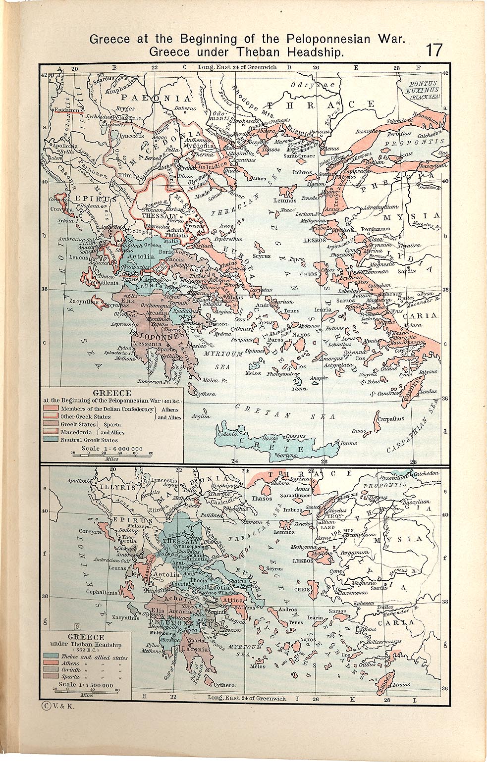
- I'd say you're done after that unless any issue occurs during the FAC. Thanks for your help and I'm looking forward to the other two maps. :) Kyriakos ( talk) 22:18, 11 January 2010 (UTC)
- Main: /Historical maps
Hello MapMaster, Long time no see~
I'm now in vacation thanks to the Chinese new years, for 10 days. After a week long camping/travel in the east side of Taiwan, I now plan to stay in front of my computer for 6 days at least. Accordingly, I consider to involve myself again in the map convention. After the 1st round : collect conventions ; I pland to lead/make the 2nd round : increase harmonization between conventions. Not sure (I also have other projects).
I contact you because I need your involvement on the subpage Historical Maps conventions (draft). Please, collect all useful icons you used, and share them in this SVG toolbox of the page.
Thanks a lot Yug (talk) 09:38, 12 February 2010 (UTC)
It may be great also if you provide similar advices for "technical maps" convention, such the one you create for central park. Yug (talk) 06:17, 16 February 2010 (UTC)
I want to include your excellent map about Bangladeshi languages in Punjabi Wikipedia and in Punjabi language. Can it be translated into arabic script? -- Khalid Mahmood ( talk) 10:39, 11 March 2010 (UTC)
- I would be happy to do this. I need to rework the map anyway, since my source map has some new data.
- If you could give me the Arabic wording, I would be happy to put something like this together. Thanks for your kind words, MapMaster ( talk) 19:18, 31 March 2010 (UTC)

Please help me make a nicer looking version of this map which would have improved fonts (it might be a good idea to keep the color of titles within the Lower Galilee region in black and keep the rest of the titles in a less noticeable color) and which would have nicer colors in general (I would appreciate it if you would be able to still use standard topographical colors so that the other users would be able to understand where the mountainous regions are and where the valleys are). thanks in advance! TheCuriousGnome ( talk) 19:28, 31 March 2010 (UTC)
- Oh and I would also appriciate it if you could make an individual map for the
Upper Galilee as well.
TheCuriousGnome (
talk) 19:44, 31 March 2010 (UTC)
- Hey, Curious, are you still interested? My apologies, but I was tied up with my paying job. Let me know,
MapMaster (
talk) 14:18, 30 May 2010 (UTC)
- Still interested. :) TheCuriousGnome ( talk) 03:46, 14 June 2010 (UTC)
- Hey, Curious, are you still interested? My apologies, but I was tied up with my paying job. Let me know,
MapMaster (
talk) 14:18, 30 May 2010 (UTC)

Could I possibly interest you in another map project? I am working on the Battle of Grunwald article, which is going to celebrate its 600th anniversary this July 15. It would be awesome if you could do battle plans. The current plans not only look ugly and childish, but also are very inaccurate, missing some key developments. There is another plan File:Grunwald (begining) Lithuanian.svg, but it shows only the very beginning & end and is way too complicated (even I have trouble reading it). I have the plans that you could use on my computer. They are not complicated and should not take that long. I would need to email them to you as they are copyrighted. So what do you think? Renata ( talk) 13:52, 30 May 2010 (UTC)
_Lithuanian.svg)
- Renata, good to hear from you again. I have just returned from a sabbatical and I would love to undertake your project. Let me review your information. I could certainly get something done before July. Thanks, MapMaster ( talk) 14:15, 30 May 2010 (UTC)

I hope you don't mind, I've taken your map of Babylonia and modified it to show the same region in c.1790BC, for a proposed un-stubbing of the Rim-Sin page. It's my first time using Inkscape and I obviously need some work (the font handling on my additions look terrible for reasons which elude me) but hopefully this early draft gives you an idea of what I'm trying to do. If you have no objections and if I sort out the font issues (and maybe get better at drawing freehand shapes) I'll probably try to make a similar edit on a map for the Samsu-iluna page I'm also working on.
Zoweee ( talk) 07:13, 12 July 2010 (UTC)
I am a contributor to Wikipedia, but have no experience editing maps and am looking for some help that I hope you or someone you know could provide.


I would like to change two existing maps of Lebanon so that they fit better with an article I am writing. On the map to the right showing Lebanese rivers it would be great if all rivers could be shown in the same colour and the background color would fit so that rivers can be easily recognized. Ideally the names of the major rivers would also be added, which I can provide. On the map of governorates of Lebanon to the right I would like the boundaries of Beirut and the boundaries between the two governorates in the South to be removed so that the boundaries of the four Regional Water Establishments in Lebanon (South, Bekaa, Beirut-Mount Lebanon and North) will be shown instead of the boundaries of the six governorates. Since you seem to be quite familiar with maps on Wikipedia and have apparently helped many other users, could you help with these requests or tell me who else could help?-- Mschiffler ( talk) 23:43, 30 January 2011 (UTC)
Hello, I can see that you're particularly adept at mapmaking, so I thought you might be interested in this challenge. Best, -- Alexandru Demian ( talk) 10:45, 13 February 2011 (UTC)
Hey Mapmaster, people keep reverting the Image of the Levant to an arbitrary picture that includes parts of Iraq and Saudi Arabia, which are clearly not parts of the Levant, do you know how we can get page protection on the Levant article? Thanks. Lazyfoxx ( talk) 00:21, 10 March 2011 (UTC)
Hi,
You appear to be eligible to vote in the current
Arbitration Committee election. The
Arbitration Committee is the panel of editors responsible for conducting the Wikipedia
arbitration process. It has the authority to enact binding solutions for disputes between editors, primarily related to serious behavioural issues that the community has been unable to resolve. This includes the ability to impose
site bans,
topic bans, editing restrictions, and other measures needed to maintain our editing environment. The
arbitration policy describes the Committee's roles and responsibilities in greater detail. If you wish to participate, you are welcome to
review the candidates' statements and submit your choices on
the voting page. For the Election committee,
MediaWiki message delivery (
talk) 16:11, 23 November 2015 (UTC)
|
User talk:MapMaster/Archive01
User talk:MapMaster/Archive02 |
Great job on the maps. They are very accurate and illustrating. Thanks again! Omegastar ( talk) 13:36, 24 February 2008 (UTC)
If you want a translation for one of your maps, in French, German, or Arabic, contact me, I would love to help you! --Escondites talk 12:06, 28 December 2006 (UTC)
Could you please do a translation of this map in Arabic? I can translate the names but wouldn't know how to edit it. Thanks a lot. -- Aa2-2004 ( talk) 16:00, 15 December 2010 (UTC)
Thanks!! Good work as usual. I was in my sea house in the Christmas days, so sorry for late reply. Well, my grandaunt has an Italian old encyclopedia with a VERY detailed map of Italian states during the Middle Ages (the best one is truly a puzzle with even the minorest seignories, it's stunning - it is about around 13th-14th centuries however). I'll provide you, if you want, as soon as I'll be able to scan it. Bye and thanks again. -- Attilios 11:34, 3 January 2007 (UTC)
Thank you for the skill and care you are putting into these goodlooking maps. They enrich every article in which they appear. -- Wetman 12:47, 9 January 2007 (UTC)
Hello MapMaster,
On your userpage you stated that you are open to map requests. If it's possible, I'd like to request a map of the Habsburg Monarchy from 1713-1740. There are a few maps around showing Austria-Hungary but none of the monachy before that time. It would greatly enhance an artikel dealing with that subject. I hope you'd like to help me with it.
Regards, nl:Gebruiker:Sir Iain 213.10.202.180 21:56, 9 July 2007 (UTC)
Your maps are beutiful, informative, indicate hours of hard work, and show expertise in conveying information visually. I just had to give you this:
|
|
The Barnstar of Diligence | |
| For creating beautiful and informative maps with attention to detail, quality, and practical value. Fishal 20:56, 7 September 2007 (UTC) |
- Wow, I am speechless. Thank you very much. I love doing this work here and in particular adding some non-text information and snazz to Wikipedia. The work is not all that hard, but yes I do try hard to be precise. For that, I have to thank all the many folks (indeed, experts) who've written back with corrections, suggestions, and information for me.
- Quite a boost!! Thanks again!
MapMaster 03:45, 8 September 2007 (UTC)
- You're welcome! I had just encountered some of them at Byzantine Empire, took a look at the others on your user page, and realized you needed another one. They are definitely a notch or two better than any other maps I've seen on Wikipedia. Fishal 16:05, 8 September 2007 (UTC)
Thanks for the tips, I'll fix it in a bit. :)
- Now, what's your next map?? MapMaster 03:44, 25 September 2007 (UTC)
I've been looking for info to replace raster Map of Ontario with an SVG one. I've found some places with clear data but they're always copyrighted. I thought about tracing the current map, but it isn't detailed enough. Do you have any suggestions on how I can find that info? Vidioman 10:58, 25 September 2007 (UTC)
- Since I'm lurking here I'll go ahead and answer. You're going to run into that problem a lot as almost everything for Canada is copyrighted, but if you're talking about this map (which really does need to be replaced as it's a rather obvious copyright violation) then I think everything you need is available provided you have GIS software to import it into. Province borders, cities, rivers, and lakes can all be gotten from DCW, Great Lakes boundaries can be gotten from there too, but you might get a better layer from the National Atlas. The background relief can be gotten from USGS, I can probably hook you up with that if you want it as I already have relief for North America downloaded and pre-processed for my own use. Kmusser 13:21, 25 September 2007 (UTC)
I don't have GIS software. I was referring to the black white and red locater maps, but if the relief map should be re-done, I'll try it in the future. I'll take a look at those places. As for the Thunder Bay map, I don't think a locater thumb map is necessary. The Thunder Bay article already has a locater (which I want to replace), and the other page it's on is related to the Thunder Bay article. I have another version I am tweaking for the articles about highways in the area, however, and that map would have a thumb map, once I have made it. (for Ontario) Vidioman 14:56, 25 September 2007 (UTC) Ok, I took a look at DCW, and I think the map is 'squished'? (I had this problem with another source I found the other day). The projection it uses isn't appropriate for an Ontario map. Vidioman 14:58, 25 September 2007 (UTC)
- Ah, for that you should be able to take one of the existing maps from the commons and make locater maps out of it. Kmusser 15:05, 25 September 2007 (UTC)
It doesn't have outlines of the census divisions, however. Aside from city locaters, I was going to make CD and region locaters (Park locaters, etc.). Where would I get that data? Vidioman 15:08, 25 September 2007 (UTC)
- You can't, at least not legally, census division boundaries are copyrighted by Statistics Canada, though I suppose you could trace them off a paper map that was older than 50 years. Kmusser 15:32, 25 September 2007 (UTC)
There is no map of CDs older than 50 years, they were redrawn less than a decade ago. But if that's so, then aren't all of the Ontario maps violating a copyright? Vidioman 15:53, 25 September 2007 (UTC)
- Yes, unless someone got permission from StatsCan, which I doubt but might be possible. Kmusser 16:49, 25 September 2007 (UTC)
By CD I mean the districts, regional and single tier municipalities and counties of Ontario. I don't see how StatsCan could hold a copyright on that? [1] Vidioman 17:13, 25 September 2007 (UTC)
- They don't for the others, just for the Census Divisions, which usually follow municipal and county boundaries, but not always (and technically it's for their maps of the boundaries, not the boundaries themselves, but since they're the only source . . .). I don't know of another source for administrative boundaries - and anything produced by any Canadian government agency is still going to be copyrighted (they each have their own terms though and some might be loose enough to allow use on wikipedia), also if you found a U.S. government produced map showing Canadian administrative boundaries that would be legal, but I've never seen one. Kmusser 17:55, 25 September 2007 (UTC)
Would it be possible to use the written descriptions (these are usually posted on elections Canada websites) which describe, in detail, the path the boundary takes, and then use that? It would be extremely time consuming but possible. You could also ask Earl Andrew where he got the data in the first place. Vidioman 18:07, 25 September 2007 (UTC) Also, census divisions ARE county boundaries. Census division is the blanket term for all districts, counties, regions, single-tiered municipalities, etc., in Canada. The level of division immediately below Provincial and Territorial is a Census Division. Vidioman 18:09, 25 September 2007 (UTC)
- Using written descriptions would definitely be ok (though tedious), Earl Andrew and Qyd's maps are both from StatsCan maps and thus probably not legal, I'm not about to spend a bunch of time playing policeman though. Kmusser 18:29, 25 September 2007 (UTC)
Ok.. I created a map on Ontario by modifying Canada geolocalisation, BUT, going through the licensing, I noticed that Canada geolocalisation came from Carte administrative du Canada.svg, which came from Carte administrative du Canada.png, which came from this government website. So, wouldn't that mean that, by default, this is a violation of copyright? this map is from the same source. Vidioman 17:18, 26 September 2007 (UTC)
- Atlas of Canada stuff is copyrighted, but
this map, while using the Atlas of Canada as a reference, does not look like a direct copy of their map, so it might be ok. How much tracing stuff off another map constitutes a violation is a legal grey area - the derivatives especially are different enough from the original that they're probably ok. The
relief map, on the other hand, is a direct copy (and still has the original copyright notice on it even).
Kmusser 18:09, 26 September 2007 (UTC)
- does not look like a direct copy of their map, so it might be ok.
If you look at both of them superimposed, ( image) not only does it become almost impossible to tell them apart, but you can clearly see that the grey used for international territory is identical. The map of Ontario's divisions ( image) superimposed on it's source (Environment Canada's GeoSearch2006) shows it not only had to be scaled up considerable but is also fairly inaccurate, and looking at their copyright information, ( source) it appears that it would be OK to use it here, so long as the link to StatsCan's website is included with mention that that is the source of the image's data. Vidioman 12:52, 27 September 2007 (UTC)
- Vidioman, I really don't see a problem with using the graphic data (e.g. boundaries) on a copyrighted map to create your own map. The copyright applies to the way the data is presented and not the data itself. As long as your new map is not a direct copy of the copyrighted map, as long as you're not trying to make money off the new map, I just don't see a problem developing. To keep from making an exact copy, do not show exactly the same area, do not use the same colours, and do not copy the copyrighted map by mechanical means. By adding your own design decisions, I firmly believe you will be making a new work (of art!!). Hope this helps, MapMaster 13:05, 27 September 2007 (UTC)
- Well Wikipedia is a commercial use, otherwise we could use the StatCan stuff directly, but anyway, yeah, as long as yours isn't a direct copy and you cite your sources you should be fine. Also if you want you could ask StatCan permission, for all I know they might be happy to grant it, I've never asked. Kmusser 14:11, 27 September 2007 (UTC)
I created
this. I traced the boundaries from
Image:Ontario subdivisions.PNG but because of the low resolution (of both maps) the borders are really jagged and approximate. I wanted to avoid that, but it would be too hard to do so.
Vidioman 01:49, 28 September 2007 (UTC)
I re-did the map, tracing things and building it like I did the Thunder Bay map, instead of the weird fractured way the original was made. (
new map)
Vidioman 18:13, 28 September 2007 (UTC)
Hello there - you don't know me, I think, but I stumbled across your name at a MilHist peer review as a possible good source for maps. I've recently uploaded this map: Image:Gebora_and_1_Badajoz.jpg, but I'm concerned that it's very borderline for copyright purposes. Therefore, if you're still active, aren't too busy, and feel inclined, would it be OK for me to humbly, on bended knee, request an equivalent from your good self? I've tried to use InkScape myself to make maps, but my artistic skills are frankly non-existent! Thanks very much if you can help out... hell, thanks very much even if you can't! Carre 18:10, 31 October 2007 (UTC)
- I'd love to. This may take me a couple of weeks since I promised to work on a Muslim history map first. I myself like miliary history and would welcome the opportunity. I was very disappointed to find that the most recent military history Featured Article (forget the name -- it was concerning a 19th century battle on the Afghan frontier) did not have a single good map. What's up with that, anyway?!?!? Thanks,
MapMaster 21:23, 6 November 2007 (UTC)
- That's wonderful! I've written a few 19th century MilHist articles, including an FA (
Battle of Barrosa), and finding maps that aren't in copyright is very difficult for that time period. Unfortunately, contributors with your map making skills are few and far between, and most of us aren't even aware of your existence (writing Barrosa, I had a comment that it needed a map and it took me weeks to find a PD one I could use). The couple of weeks time scale isn't a problem for me, since I need to get the relevant article (
Battle of the Gebora) through LoCE, GA review and MilHist A-class review before I take it to FAC... but it will be there eventually, and hopefully with your map adorning it!
Carre 21:34, 6 November 2007 (UTC)
- Hello again. Yes, your suggestion sounds good to me. 350px shouldn't be a problem (I may have to shift the image of Mortier to make room for the larger size), and colours would certainly be nice . I'm afraid I don't know the scale on that version of the map. Look forward to seeing your work in the article!
Carre 10:26, 9 November 2007 (UTC)
- That's a great map, and I can't really criticise it at all! The colours are fine for the Spanish troops, so no problems there. The boundary you've chosen means that a couple of the outlying forts around Badajoz are dropped off, but that doesn't matter too much for this article. When I get to the 1st (and 2nd, for that matter) sieges of Badajoz, I will probably be able to find a more detailed map of the fortress that you could possibly use then to complete it. (Most military maps of Badajoz are concerned with 3rd Badajoz siege, so no use for 1st or 2nd). Elvas and Campo Maior are really too far away from the area of the map to include, so not fitting those in is fine too.
- By campaign map, do you mean a kind of higher level one, showing the important places (such as Elvas etc)? Something showing the lines of march for both the Spanish and the French? That sort of thing would fit in well in Prelude to battle, I agree (I used one for Battle of Barrosa), but I don't have anything to use as an original source. Of course, if you can come up with one with nothing to work from, it'd fit in very nicely.
- Anyway, I love the new map, so thanks very much for putting in the effort! Carre 08:59, 13 November 2007 (UTC)
- Hello again. Yes, your suggestion sounds good to me. 350px shouldn't be a problem (I may have to shift the image of Mortier to make room for the larger size), and colours would certainly be nice . I'm afraid I don't know the scale on that version of the map. Look forward to seeing your work in the article!
Carre 10:26, 9 November 2007 (UTC)
- That's wonderful! I've written a few 19th century MilHist articles, including an FA (
Battle of Barrosa), and finding maps that aren't in copyright is very difficult for that time period. Unfortunately, contributors with your map making skills are few and far between, and most of us aren't even aware of your existence (writing Barrosa, I had a comment that it needed a map and it took me weeks to find a PD one I could use). The couple of weeks time scale isn't a problem for me, since I need to get the relevant article (
Battle of the Gebora) through LoCE, GA review and MilHist A-class review before I take it to FAC... but it will be there eventually, and hopefully with your map adorning it!
Carre 21:34, 6 November 2007 (UTC)
I have considered using standards. I tried the one at en:Wikiproject:Maps, I found it too garish. I tried the fr:Wikipedia colours, and they were a bit too dull for my tastes, though I do prefer them. My main problem with the fr:Wikipedia standard is that when viewed greyscale, the shades for land and water are too similar. Taking into account the colour blind and LCD monitors which tend to have a "washed out" display, and my design is much more appropriate in terms of accessibility.
Additionally, those maps don't account for certain things maps might be used for. There is no option for roads, which some of my maps require. When pointing out different cities and requiring different colours to do so, the "standard" colours were, in my opinion, to garish for the job, and lacked a darker colour for border areas. so I created my own standards for that as well.
The colours I chose came after about a week of browsing maps on both the French and English Wikipedias (I'm a member at both though not very active at the French one) and finding averages, or seeing what other people has used, as well as consulting traditional paper maps to see how various professionals have dealt with the issues of dealing with displaying their information. The colours for borders and territories are based on various maps displayed on en:Wikiproject:Maps and the French standard, as are colours for water bodies, roads, and primary selections. Parks (which I also use as secondary selections as I like that particular shade of green) is based on the old colour for infoboxes of National parks. The yellow and purple are my own choice, I decided on those colours after browsing other maps and seeing which colours were used when displaying many colours and ensuring that they wouldn't be similar in grey scale or close enough to cause confusion. The topographic map scale is from the various topographic maps posted on the French Wikipedia, unaltered though I left the scale with single digit numbers so that I could alter it to suit my own needs. (That is an old version of the map, I don't have a raster of the current one.) The subway map colours were created for a project outside of Wikipedia entirely, I simply needed a more organized way to access the colours. I went through a couple dozen different mass transit maps 'harvesting' colours and trying to find the best ones. Those colours can also be used on future maps, if needed.
Most of my interests in map making are in small scale urban maps, ( a work in progress) so I have created colours to help me with that, and will expand the colour list in the future.
Simply put: I don't think the colours chosen for the "standard" are good enough, and I have chosen my own colours, but I have also taken the standard into consideration and tried to stay as close to it as possible while also satisfying my own perfectionist desires. To be honest, I find those Ontario maps hideous (That resolution is shit for an SVG map, the shores lines are much too jagged) and should I ever come across free data that I can actually use I will replace all of those maps. The hockey team maps will also be replaced when I find that source, and I am currently working on a cleaner version of the Thunder Bay map, which will be versatile and can be used in multiple articles. I have continuously postponed articles relating to local expressways.
I think I've covered everything? :P vıdıoman ( talk • contribs) 02:39, 22 November 2007 (UTC)
Tricky map request: Covering of the Senne
OK, I think this might be fairly tricky, but I'll ask anyways. Can you superimpose a map of the former route of the Senne river on a map of the modern downtown or that of 1887, such that the Central Halls would be visible? Please also include the Brussels Stock Exchange and Greater and Lesser sluice gates, and the Central Halls... if possible, the Brussels Stock Exchange being the most important. I think all the base maps you would need either are already in the article covering of the Senne, or are linked to at the bottom. I don't really mind whether the new things are superimposed on the old, or the old superimposed on the new.
Sorry that request wasn't really that coherent, but I was trying to get out a lot of stuff at once. Let me know what you think or if you need any help at all, and if you'll be able to do it. Thanks! - Oreo Priest 16:15, 22 November 2007 (UTC)
- Also, because the maps in the article are in the public domain, you wouldn't really have to start from scratch if you don't want to.- Oreo Priest 16:17, 22 November 2007 (UTC)
I would be interested in trying to make a map for this article. I am always up for a challenge. Let me do some research this weekend and then get back to you with some ideas.
Thanks for thinking of me, MapMaster ( talk) 03:54, 30 November 2007 (UTC)
- I just realized now that it would also be nice if you were able to do a French version to place on the corresponding article on their WP, from which the English one comes. Would that be OK? - Oreo Priest 09:37, 30 November 2007 (UTC)
Please include:
- The series of boulevards consisting of Hainaut Boulevard (now Maurice Lemonnier Boulevard), Central Boulevard (now Anspach Boulevard), North Boulevard (now Adolphe Max Boulevard) and Senne Boulevard (now Émile Jacqmain Boulevard)
- The Greater and Lesser sluice gates' locations can be inferred from where the Senne entered the pentagon, it may not be necessary to include them
- The Stock Exchange
- The Halles Centrales (Central Halls), visible on the 1883 map at the bottom of the page
- Place De Brouckere for sure and perhaps Place Rogier
- Maybe the former fountain at place De Brouckere
- The Augustinian convent, which was in between the two branches of the "Y"
- The modern (post 1955) course of the Senne, under the left half of the Small Ring, I think that should be clear enough.
- Maybe the fr:Palais du Midi
- Maybe the north and south railway stations to provide context
Please remember to use a neutral language in labelling; either English or BOTH French and Dutch, this sort of thing is very sensitive in Belgium. For the French map, if you choose to do one, just French will do. Thanks a bunch, and keep the questions coming! - Oreo Priest 10:54, 2 December 2007 (UTC)
- That map in its basic form is good, though you're right it lacks wow factor. (Which doesn't really bother me.) One issue I have is that I think the Senne is a bit too far to the northwest. While map here is obviously low quality, the course of the Senne corresponds roughly to the official maps I've seen. Also, the small ring was strictly within the bend of the canal at the top left. Also, please include The modern (post 1955) course of the Senne, under the left half of the Small Ring, and Adolphe Max Boulevard as part of the "Y". Thanks, Oreo Priest 10:19, 6 December 2007 (UTC)
- That map is great! All three of your suggestions would definitely be good to implement. I think widening the Senne would be a good start, as I think on that scale that the line is actually thinner than the river itself. If you're looking for wow factor, maybe also change the colour of the background... perhaps to a light yellow... that may zest it up (although the suggestion is purely stylistic). Look forward to hearing from you again! - Oreo Priest 05:36, 6 January 2008 (UTC)
- The streets in the upper town (bottom right) you added are not really as useful as the ones in the lower town (top left). At any rate, the most useful streets to add would be those mentioned in the article, especially Adolphe Max Boulevard, the right hand part of the "Y".
- The 1883 map linked to at the bottom of the article has most of what I requested, mostly along the central boulevards. The Stadhuis is not really relevant to the context of the article. More or less everything else in the checklist above is there, but only the Stock Exchange and the Halles Centrales [and the modern course of the Senne] are really important; you can choose to include or reject everything else based on what you think would look best. Thanks! - Oreo Priest 12:28, 8 January 2008 (UTC)
Getting close
Beautiful!! I think it's almost ready. I do, however have a handful of nitpicky changes that should be made:
- Bourse and Halles Centrales MUST be either a calque (Stock Exchange and Central Halls) or bilingual French/Dutch, as this sort of thing is very sensitive. I like the way you put only the names of the central boulevards and not rue ... straat, it's much tidier that way.
- I'm pretty sure the 1837 (not 1833) course of the Senne is what's superimposed
- I think there should be an arrow pointing towards Bourse like there is to the Halles Centrales for clarity
- I think the Halles Centrales should be labelled as demolished 1958 to avoid confusion
- I think you should delete all of the street names that aren't the central boulevards (Lemonnier, Anspach, Adolphe Max, Jacqmain); they aren't mentioned in the article and I think they detract from the focus a bit in addition to their two-languaged names (unlike the central boulevards) creating another thorny linguistic issue
- Similarly, I think you should delete the Stadhuis; it isn't really relevant, distracts, and would need to be calqued or bilingual
- Could you please label the Lesser Senne (the wobbly bit outside of the pentagon) and/or the Charleroi Canal (the straight section in the top left just outside the pentagon) and/or the modern course of the Senne which is under the left arm of the pentagon? I doubt you'll be able to do all of them so I'll leave it to your judgement what to do
- It would be nice if you could say Senne (Zenne) or Senne/Zenne instead of just Senne, again for neutrality, but if this doesn't work stylistically, don't worry about it too much
Sorry for being so picky and thanks a million! I can almost taste it it's so close... In fact, I've already put it in the article. - Oreo Priest 21:34, 15 January 2008 (UTC)
- All of that is ok. You're the experienced cartographer after all. Re-add the Stadhuis (as Town Hall) then. As for the peripheral streets, try to remove Schlachthuis, replacing it with Poincaré, solely for ease of rendering. Niewpoort is ok now that I think about it, but change Lakense to Laeken (only per name of the article in WP).
- Neither of the two stations would be visible on the map, but they would be good to include. The only way I can see this being done (which shows where they are anyways) is putting an arrow pointing south along Lemmonier (to South Station) and one north along Adolphe Max (to North Station). I hope I explained that clearly enough... I'm sure you'll think of something.
- To be honest, now that I think about it, I'm not sure enough about exactly where the Senne goes now to indicate it on the map. It's in the prose and the readers should be able to infer it.
- Once you're done the English map, I'll just write up a list of what needs to be substituted for French and Dutch versions. Thanks. - Oreo Priest 11:21, 16 January 2008 (UTC)
- And as for the edit summary "Wordsmithing", take a look at
this for a laugh. -
Oreo Priest 11:37, 16 January 2008 (UTC)
- How's this: "He wanted to attract the middle class, most of whom had left the dingy downtown for the cleaner suburbs, including the Leopold quarter (now often called the European quarter) and Louise Avenue, causing a large loss in tax revenue for the city."
- As for Antwerp gate: The reason it's there is before I had your map, I needed some frame of reference to explain where the river left the city. It is located where Laeken meets the pentagon. It is mostly a historic name because it used to be a gate to the city through its old walls; a standalone gate only existed for less than 20 years (one of them being 1837), being destroyed in 1838. There still is an Antwerp gate, but it's just a name given to an intersection. I don't know how good your French is, but the fr:wp has a good article on it: fr:Porte d'Anvers. In short, you can include the building or the intersection if you want, but the main reason it was mentioned at all was to help with localization before there was a good map. - Oreo Priest 15:13, 16 January 2008 (UTC)
Yes we are
She's a beauty! I think that does it! I'll let you know when I have the French and Dutch translation requests ready, which shouldn't be too long. Well done! - Oreo Priest 18:46, 16 January 2008 (UTC)
Other Langages
To save space, I'm going to write EN:FR:NL for each caption which needs to be changed. What I haven't listed does not need to be changed.
- Yellow box:Parcours urbain de la Senne en 1837 [br] en surimpression sur la actuelle ville de Bruxelles:De Zenne [br] Loop in 1837 [br] Getekend doorheen hedendaags Brussel-stad
- Lesser Senne:Petite Senne:Kleine Zenne
- Charleroi Canal:Canal Charleroi:Kanaal Brussel-Willebroek
- Nieuwpoort:Nieuport:Nieuwpoort
- Laeken:Laeken:Laken
- Antwerp Gate:Porte d'Anvers:Antwerpsepoort
- Augustinian Church, demolished 1893:Église des Augustins (démolie en 1893):Augustijnenkerk (afgebroken in 1893)
- Central Halls (demolished 1958):Halles Centrales (démolies en 1958):Centrale Hallen (afgebroken in 1958)
- Stock Exchange:Bourse:Beurs
- South Station:Gare du Midi:Zuidstation
- North Station:Gare du Nord:Noordstation
- I would remove the scale in yards, as the unit is only used by English speakers
- I would name the files voutement de la Senne and overwelving van de Zenne or some variant, but this is merely a suggestion
I think that should be enough. Any questions, let me know, and let me know where I can find them when they're done. Thanks! - Oreo Priest 12:46, 17 January 2008 (UTC)
- Good job adding the French map. Apparently I made a few translation errors, as pointed out by the original writer of the article. Here they are verbatim (If you don't understand the French, just let me know).
- Merci beaucoup pour la version française du plan. [I've since told him it was your work] Il y aurait cependant quelques corrections à demander au graphiste:
- dans le cadre: remplacer en surimpression sur la actuelle Ville de Brussels par: en surimpression sur le plan actuel de la Ville de Bruxelles (meilleure formulation et nom de la ville en français)
- dans le plan: remplacer Antoine Daesaert par :Antoine Dansaert, Canal Charleroi par Canal de Charleroi et Artevelde par Van Artevelde (puisque il s'agit du nom d'une personne, Jacob Van Artevelde)
- Thanks,
Oreo Priest 13:50, 31 January 2008 (UTC)
- I have made the changes suggested on the French map and I also changed the street names on the English map.
- Could you go to the French map and write a description in French? That would help, I think. MapMaster ( talk) 23:55, 31 January 2008 (UTC)
Good article
So the article just passed its GA nomination, and your map was a big help. I think I might shoot the moon and try to get the article to FA, but I also might not. Thanks again for the wonderful map! - Oreo Priest 17:50, 20 January 2008 (UTC)
Hi MapMaster,
Just a quick note to let you know the Battle of the Gebora article got to FA with no problems, so if you're into userboxes, I guess you deserve this:
|
| This user helped promote Battle of the Gebora to featured article status. |
The wonderful map you made for the article helped immensely :) Carre ( talk) 14:02, 9 December 2007 (UTC)
Why is it claimed that this shield boss is Gallo-Roman and from 400 AD?? This artifact is located at the Metropolitan Museum in New York City, and its I-Net site states that its a Longobardic Shield Boss from the 7th Cen. AD northern italy. http://www.metmuseum.org/toah/ho/06/eust/ho_1984.184.1,2.htm Daufer
- It is exactly the same image as that photo which you have uploaded. Wandalstouring ( talk) 16:55, 29 January 2008 (UTC)
- I went back and checked my notes and I have an actual photo of the display card with the "Gallo-Roman" stuff that I wrote. However, I do see that the Met webpage says that this shield is Lombard/Langobard. I ended up researching the 400 AD Vermand treasure and I found the following description of the shield boss found in that trove:
- "The umbo, or shield boss, has a tall, sharply pointed cone set on a circular rim decorated with four round paste cabochons imitating chalcedony". in their Bulletin
- That certainly does not describe this shield boss. So I can only suppose that the display card I photographed referred to another shield boss also in the case. I have uploaded a new version: Image:Langobard Shield Boss 7th Century.jpg. I will substitute this for the misnamed one when the Usage link works.
This seems overdue. - Oreo Priest 11:03, 1 February 2008 (UTC)
- Well, this is a wonderful surprise. Thank you very much for this. I love making maps and wish I could spend more time doing it. This certainly was a challenging one, trying to overlay data from two century-old maps with modern data.
- Keep up the good work there, Oreo, and I would love to work with you on another project. MapMaster ( talk) 17:07, 4 February 2008 (UTC)
MapMaster, thank you very much for taking the time to make a map for Dahlak Archipelago! I found the article after watching a PBS documentary related to it, and was disappointed to find no map - and I'm surprised (and delighted) that my request didn't take long to be fulfilled.
If you don't mind me asking, how did you make the map? (If you explained this before to someone else, feel free to link me to that discussion.)
Again, thanks a lot! -- Iamunknown 06:46, 13 February 2008 (UTC)
- Hehe, I just noticed on your user page that you mention you generally use Inkscape (I hope you'll forgive me for jumping the gun and asking you anyways :). Do you load a rasterised map and use it as a reference? Again, thanks. Feel free to answer (or not answer) my questions - and sorry for all of them! I'm just excited right now. :) -- Iamunknown 06:50, 13 February 2008 (UTC)
Thank you very much for the map at Seljuk Sultanate of Rûm. That article has needed a legible map for quite some time. I do not wish to appear ungrateful but would you be able to make some minor adjustments? The Black Sea port of Sinop was not yet part of Seljuk territory in 1190; the conquest of Sinop in 1214 followed the acquisition of Antalya on the Mediterranean in 1207. In short, there was no time when the Seljuks possessed a port on the Black Sea without a port on the Mediterranean. Furthermore the eastern extension did not happen until the 1220s and 1230s. The most useful map would represent Seljuk territory at the death of its greatest ruler Kayqubad the Great in 1236. I have found some reasonably accurate maps online: Encyclopaedia Britannica and Eron Coins (click on “Seljuqs of Rum” below the coin). Once again, thank you for making a map for the Seljuks of Rum. I love your work and can recognize it instantly. Regards, Aramgar ( talk) 14:26, 15 February 2008 (UTC)
- Thank you for your kind words. Based on its listing at Category:Former country articles requiring a map, I saw that the Seljuk Sultanate of Rûm article, and similar articles in other languages, needed a locator map, so I put one together.
- I was very happy to make the adjustment for Sinop, which I have now uploaded. If this is still not correct, let me know.
- Regarding the eastern territories, I used William Shepherd's 1911 "Map of Europe and the Meditteraean Lands about 1190". If you have additional or conflicting information, I could review and incorporate that into my map.
- I could also look into making a 1236 map, if you felt that was desirable.
- Thanks for your own work here at Wikipedia! Sincerely, MapMaster ( talk) 23:24, 15 February 2008 (UTC)
- Thank you for the modifications to [Image:Seljuk Sultanate of Rum 1190 Locator Map.svg]. If you have time for such in the coming weeks, I believe a locator-style map reflecting the Seljuk Sultanate of Rûm at the time of the death of Kayqubad I would be an excellent addition to Wikipedia. The two links above are accurate. Thank you again. Regards, Aramgar ( talk) 18:34, 19 February 2008 (UTC)
| English: | Polski (Polish): |
|---|---|
| Baltic Tribes | Ludy Bałtyjskie |
| c. 1200 N.E. | ok. 1200 n.e. |
| Baltic Sea | Morze Bałtyckie |
| Gulf of Riga | Zatoka Ryska |
| Lake Peipus | Jezioro Pejpus |
| Livonians | Liwowie |
| Latgalians | Łatgalowie |
| selonians | Zelowie |
| Semigallians | Zemgalowie |
| curonians | Kurowie |
| Lithuanians | Litwini |
| aukstatians | Auksztoci |
| Highland Lithuanians | dont write |
| samogitians | Żmudzini |
| Lowland Lithuanians | dont write |
| Daugava | Dźwina |
| berezina | Berezyna |
| Neris | Wilia |
| nemunas (neman) | Niemen |
| Yotvingas | Jaćwingowie |
| (sudovians) | (Sudowie) |
| narew | Narew |
| Bug | Bug |
| vistula | Wisła |
| poles | Polacy |
| Galindians | Galindowie |
| skalvians | Skalowowie |
| sambians | Sambowie |
| nadruvians | Nadrowowie |
| Bartians | Bartowie |
| Prussians | Prusowie |
| Warmians | Warmowie |
| Nantongius | Natangowie |
| Pogesanians | Pogezanowie |
| Pomesanians | Pomezanowie |
| kilometres | kilometry |
| miles | mile |
| English: | Polski (Polish): |
|---|---|
| Sultanate of Rum | Sułtanat Ikonium |
| Principality of Armenian Cilicia | Księstwo Małej Armenii |
| County of Edessa | Hrabstwo Edessy |
| Principality of Antioch | Księstwo Antiochii |
| Byzantine Empire | Cesarstwo Bizantyjskie |
| County of Tripoli | Hrabstwo Trypolisu |
| Kingdom of Jeruzalem | Królestwo Jerozolimskie |
| Ascalon | Askalon |
| Acre | Akka |
| Emirate of Damascus | Państwa Seldżuków |
| Euphrathes | Eufrat |
| Mediterrean Sea | Morze Śródziemne |
| Assasins | Asasyni |
| Near East | Bliski Wschód |
| Fatimid Kalifate of Cairo | kalifat Fatymidów |
| kilometres | kilometry |
| miles | mile |
| betwen the firs and second crusade | pomiędzy pierwszą a drugą krucjatą |
| Tarsus | Tars |
| Sis | sis |
| Konya | Konya |
| Harran | Harran |
| Aleppo | Aleppo |
- Greetings. MapMaster, please excuse my orthographic mistakes in English. I translate to Polish words from this map, two words you dont need write, like lowland and higlands lithuanians. In polish we always only use names Żmudzini (samogitians) and Auksztoci (aukstatians). In few days i send you rest of translations on Polish, from your maps.
- About your polish wiki user page- i want write translate, but Roo72 been faster ;p.
- About crusades map:Just translate your map to polish without look for this pl:Grafika:Panstwakrzyz.png, i dont know why i write city names ;p. thanks.
You're do a great job with this maps.
Killroyus|
Talk 11:33, 16 February 2008 (UTC) and 12:00, 16 February 2008 (UTC)
- Hello, sorry for silence from my side. I readed your messages today. Thanks for translated into polish Image:Panstwakrzyz 1135 PL.svg. I insert it into other articles.
Image-Panstwakrzyz.png (my unperfect translate) will be deleted. —Preceding Killroyus| Talk 15:48, 29 February 2008 (UTC)
- Hey, i made a mistake in name -one of those countries- Fatimid Kalifate of Cairo. In Polish must be Kalifat Fatymidów not like now- kalifat Fatymindów Killroyus| Talk 17:19, 20 March 2008 (UTC)
I come to notice and thank you, the article Battle of the Gebora is the today feature article of the english wikipedia, your Gebora's battle maps is really great in this article and have probably help the article to be nominated. 210.203.61.15 ( talk) 14:08, 19 February 2008 (UTC)
- Thank you for your kind words. The battle map was fun to make. MapMaster ( talk) 21:10, 19 February 2008 (UTC)
Hello, I just wanted to let you know that apparently there was a mistake in Image:Baltic Tribes c 1200.svg (Curonians should have been colored in green). So I fixed it, and while at it I tweaked some other colors. I also updated Lithuanian and Latvian versions of the map. Hope you are ok with that. Renata ( talk) 16:59, 23 February 2008 (UTC)
- Renata3, the fix to the Baltic tribes map is fine with me. From what little information I saw this morning, yes, the Curonians were a West Baltic tribe and should be colored green. Thanks for the help, MapMaster ( talk) 14:28, 24 February 2008 (UTC)
Thank you for the beautiful maps!
I would like to make a suggestion - a number of the cities that have "Babylon in the time of Hammurabi" maps were actually players in the previous millenium, i.e. the time of Sumer and Akkad. Could you make a map for this time period?
Is there any way to use a terrain background for the maps?
Sumerophile ( talk) 18:58, 4 March 2008 (UTC)
- Thanks for your kind words.
- I would be happy to make a map of the Sumer and Akkad time period. Let me see what references and sources I can find. Is there anything you had in mind??
- Regarding the terrain background, I have never done this except with terrain elevation lines such as in the map of the Battle of the Gebora. I know that commons:user:Sting is quite successful at this, but I've never inquired as to his technique. Is there any particular feature you would like me to emphasize?? Regards, MapMaster ( talk) 16:18, 5 March 2008 (UTC)
- Well the cities are listed on the Sumer page, and the articles have their coords. ( Mari, Syria and Nagar, Syria are outside the core area and could probably just have arrows pointing off the map.)
- Terrain maps are just my personal choice, like on the map on Sumer, or Google Maps [2], or Sting's maps as you mentioned. I do find it informative to see the geography of an area, because it shapes borders, trade routes, etc. But I don't know if there are terrain backgrounds available that are not copyrighted in some way.
- Sumerophile ( talk) 20:28, 5 March 2008 (UTC)
- Some more thoughts: Elam, Sumer's neighbor to the east, should be shown as well, as there was a lot of contact (often war) between the two groups. Susa is near Sumer's core area, but Anshan (Persia) might be shown with an arrow.
- The Elamite city Awan has not been located, but is thought to be near Sumer's core area as well. A few Sumerian cities have not been located either, but there are guesses for their general vicinity - I'm not sure how (if) that would be designated on a map. Sumerophile ( talk) 00:40, 7 March 2008 (UTC)
I finished a crude map on the initial troop movement and battles here. Wandalstouring ( talk) 10:17, 18 March 2008 (UTC)
- Thanks, Wandal! I enjoy maps like this. Let me queue this up behind a map of Bengal languages (see my Commons talk page). MapMaster ( talk) 20:21, 18 March 2008 (UTC)
Hey here- http://commons.wikimedia.org/wiki/Image:Baltic_Tribes_c_1200PL..svg you've a translated by me into polish, your map-Balts. I know u had a very much work, so i read wikibooks about Inkscape and do it self. Thanks. Ps. this is my first time with Inkscape so please, look for technical mistakes. Killroyus| Zagadaj 14:05, 24 March 2008 (UTC)
- Good job, Killroyus. Sorry I was so tardy that you had to step in. MapMaster ( talk) 16:49, 6 April 2008 (UTC)
Hi Mapmaster. I've seen your excellent work at Seljuk Sultanate of Rûm, among other places, and was hoping you might be able to help us at Mongol raids into Palestine. The concerns editors have with the current maps can be found on the talk page. Would you be willing to apply your expertise to the problem? Thanks, Kafka Liz ( talk) 10:00, 10 April 2008 (UTC)
- Well, yes, I would love to add/replace maps for the Mongol raids into Palestine. I am a bit backed up right now, Liz, and my non-Wikipedia life has become a bit busy but I hope to be able to address this in a week or so. Is that soon enough?? Thanks, MapMaster ( talk) 00:53, 15 April 2008 (UTC)
I intent to make a series (preferably 3) of maps for the Second Punic War. The request is here. Greetings Wandalstouring ( talk) 08:00, 27 April 2008 (UTC)
Could you please use a map that goes as far east as Pergamon so with one basic map I can show all troop movements of the war. Thanks Wandalstouring ( talk) 04:52, 30 April 2008 (UTC)
- I want maps of the whole war (I suggest 3 maps that fit nicely with the structure of the article), not a map showing only some of Hannibal's movements. Just take a look at the long list of generals and the many locations where fighting occurred.
Wandalstouring (
talk) 11:19, 1 May 2008 (UTC)
- That's fine so far. Do you need any help for the map? Wandalstouring ( talk) 16:07, 4 May 2008 (UTC)
- Sorry, I didn't phrase it clearly. You do the maps, I do crude maps.
Wandalstouring (
talk) 07:50, 12 May 2008 (UTC)
- Do you make progress or can I help you in any way? Wandalstouring ( talk) 07:57, 21 May 2008 (UTC)
First, thanks a lot for preparing the map.
I'm curious about this map. It shows various tribal languages covering many parts of Bangladesh. However, about 95-99% of Bangladeshis speak Bangla, so the map needs to represent the linguistic demographics proportionately. For example, what percentage of the people of Cox's Bazar (lower right corner of map) speak Arakanese such that the region is marked under the Arakanese color? Same goes for the Northwestern part of the country. Also, what percentage of the population of the inhabitants of centre-north are Garo language speakers? A very large portion of the area is marked under Garo language ... but is the percentage of Garo language speakers so high there? If the intention is to show the existence of Garo language speakers in the area, perhaps a proportionate blend would have worked better. I'm not an expert on map making, but as a casual reader, the map confuses me to think that all inhabitants of a particular region speak that language when the region is marked in solid colors (as in the region for Garo language). -- Ragib ( talk) 20:10, 14 May 2008 (UTC)
- Ragib, thanks for the feedback. You raise excellent points.
- -- First, this map is based on information here at Ethnologue. I was asked to create this map by w:bn:User:Zaheen, and I have faithfully tried to use that information to create my map, although I simplified it somewhat. Based on the Ethnologue map, I would have to believe that Garo is the predominant language within that area (which, by my guesstimate, is about 2% of the area of Bangladesh). I don't believe that it is the only language spoken there, however.
- -- Second, the figure of 95%-99% includes, I believe, anyone who speaks Bengali even as a second language. For example, according to Ethnologue, [3] Sylheti is spoken by 7 million, which is 5% or more of the population. I would like to see some comprehensive present-day statistics. Ethnologue, for example, gives a figure of 100 million Bengali speakers, as of 1994 (!).
- -- Finally, I agree that the appearance of the map would lead any viewer to underestimate the pervasiveness of the Bengali language. I myself was surprised to hear the 98% figure. Judging from the areas on the map, I would have estimated a number closer to 75%.
- I am certainly open to suggestions concerning this map. Perhaps a good caption would be something on the order of "Predominant languages areas in Bangladesh" or some such.
MapMaster (
talk) 04:12, 15 May 2008 (UTC)
- The following was posted by
w:bn:User:Zaheen on his talk page:
- Ragib, the map doesn't intend to encode the number of the speakers of a particular language, but rather tries to show the approximate geographical extent of a particular language. The demographic data that you are talking about is not at our disposal, and even if we had such data, that would complicate the current map. The current map is basically a combination of the two Ethnologue maps that are out there. It is as reliable as Ethnologue's data are reliable. -- অর্ণব ( আলাপ | অবদান) ০৩:৩১, ১৫ মে ২০০৮ (UTC)
- The following was posted by
w:bn:User:Zaheen on his talk page:
Thanks for your clarification. Actually, inside Bangladesh, as well as many other sources, Sylheti and Chittagonian are just considered dialects of Bengali [4]. That's why the figure is 98% (also see Languages_of_Bangladesh).
Also, to answer your other question, Bengali is the mother tongue of 98% of the population, per Britannica [5]. Now, that brings the question why Ethnologue gives a different figure ... apparently, Ethnologue calls Chittagonian and Sylheti dialects as different languages (while surprisingly considering all other dialects as Bengali).
Anyway, I understand the logic behind the map, just that it is somewhat confusing to a casual reader, and may be unexpected given that the 98% of the population has Bengali as their mother tongue. Thanks for taking the time to create the map. -- Ragib ( talk) 05:13, 15 May 2008 (UTC)
Your maps are excellent. When the dust settles (i.e. it's figured out whether the article will be split/moved) for Chronology of the ancient Near East I want to look into starting to add maps for the various dynasties.
The problem is, these maps add up to a lot of bytes. I had occasion the other day to use wikipedia on a dial-up line the other day and some articles were basically unusable because of all the image content that has been added. Sure, many people have high speed lines now, but there are still a LOT of people in the world on slow links and that will be true for some time to come. Big maps chew up a lot of frame real estate too.
So, I think we have to pay more attention to Real Article Size. The article size reported should be text + image size, for one. What does this all have to do with you? Well, I think we need to do map thumbnails that expand to full size if you click on them. For example, in Eshnunna.
Anyway, I didn't intend to rag on the Map guy to blame him for all the bandwidth hogging. All I said applied to pix too. :-) -- Ploversegg ( talk) 23:50, 31 May 2008 (UTC)
- I certainly don't take offense. I have long thought of you as a solid and conscientious (rather than contentious) editor.
- Regarding thumb sizes, my User Page lays out the need to have the map of a size that can be readily read from the article itself. Readers need to be able to read a sentence, consult the map, read the next sentence, etc. It's in more detail there.
- By the way, I contribute using a dial-up line, so I understand your concern, but placing the map on another page at a larger resolution doesn't resolve the problem.
- Thanks for thinking of me, MapMaster ( talk) 00:37, 4 June 2008 (UTC)
You really have a talent for making these maps! Thank you for your work. :)
If I could ask for a few tweaks:
- The arrow leading from Damascus should be much much smaller, because there was not a major troop movement from Damascus, just some raiding parties from there.
- I decreased the width of the arrow and made it less red (washed it out), both of which dilute the "strength" of the arrow. I can't make it too thin, tho, or it can't be seen.
- There is considerable disagreement as to whether or not Jerusalem was even subjected to raids, let alone a major confrontation. A better way to handle that would be to have a dotted line proceed from Damascus through to Gaza, with Jerusalem and Hebron marked as being near the line, but not specific destinations (if that makes sense?)
- I have removed the little orange starburst symbols from Jerusalem, Hebron, and Gaza. Now the arrows show that Mongols were in the vicinity of these 3 cities during these raids, something the evidence cited in the article supports, but not that they necessarily attacked these the way they did Aleppo or Damascus.
- It might also be good to show a "U-turn" arrow, or somehow provide dates:
- Damascus taken in January
- Majority of Mongol forces retreated in February
- A "power vacuum" in Palestine until May, when the Mamluks advanced from Egypt again.
- The purpose of the map is to show Mongol raids into Syria and Palestine, but not to supply their entire history. The "they left" information is understood, and is contained within the article. Adding it to the map would overcomplicate matters. Like articles, maps can be improved by leaving material out.
If you're tired of messing with it though, just let me know and maybe I'll try to adjust it based on your work! Thanks again, El on ka 05:16, 2 July 2008 (UTC)
- Glad you liked the map. Hope you like this update.
MapMaster (
talk) 03:34, 4 July 2008 (UTC)
- Better, yes, but I still feel like it could potentially be misleading to a reader. The arrows imply that the Mongols set off directly to Jerusalem and Hebron, and that's just not backed up by sources. I would rather see an arrow that went past Jerusalem and Hebron, to Gaza. We know the Mongols got as far as Gaza (though there was no conflict there). --
El
on
ka 05:15, 4 July 2008 (UTC)
- I think you're reading too much into the map, Elonka. The evidence says, as I read it, that the Mongols did more than just raid Gaza. So by the same token it might be misleading just to have one arrow pointing to Gaza. However, I will remove the arrows pointing toward Hebron and Jerusalem while I consider ways to show a more extensive Mongol presence in Palestine during this brief period. Thanks,
MapMaster (
talk) 02:39, 7 July 2008 (UTC)
- Sorry if it seems I'm being picky on this, but this point has been the cause of over a year of wrangling, an ArbCom case, and even one user being completely banned from editing medieval articles, so I want to make sure we get it right. :) How about this though? Instead of using long arrows down into Palestine, how about a fan of 2-3 "short" dashed or dotted arrows leading from Damascus, without specific end points? Then we can cover in the caption, "The Mongols launched raids southwards through Palestine, which reached as far as Gaza", and we don't need to go into any more detail than that. --
El
on
ka 11:33, 7 July 2008 (UTC)
- I didn't realize that this was a contentious issue. How about the latest version, which shows a (much smaller) arrow heading south toward a question mark? . . . toward a "?"? Hmm, how does one write this? In any case, let me know. We'll get this right yet.
MapMaster (
talk) 19:05, 7 July 2008 (UTC)
- If you want to know the gory details, check at Wikipedia:Requests for arbitration/Franco-Mongol alliance and its many subpages. There's also a current clarification active at WP:RFAR. But in any case, I like the new version much better, thank you! I recommend posting notes about it at the talkpages where it's used, and see if anyone else has concerns. Particular editors whose opinions I respect are Aramgar, Kafka Liz, and Adam Bishop, as they are highly educated on this subject. -- El on ka 19:37, 7 July 2008 (UTC)
- I didn't realize that this was a contentious issue. How about the latest version, which shows a (much smaller) arrow heading south toward a question mark? . . . toward a "?"? Hmm, how does one write this? In any case, let me know. We'll get this right yet.
MapMaster (
talk) 19:05, 7 July 2008 (UTC)
- Sorry if it seems I'm being picky on this, but this point has been the cause of over a year of wrangling, an ArbCom case, and even one user being completely banned from editing medieval articles, so I want to make sure we get it right. :) How about this though? Instead of using long arrows down into Palestine, how about a fan of 2-3 "short" dashed or dotted arrows leading from Damascus, without specific end points? Then we can cover in the caption, "The Mongols launched raids southwards through Palestine, which reached as far as Gaza", and we don't need to go into any more detail than that. --
El
on
ka 11:33, 7 July 2008 (UTC)
- I think you're reading too much into the map, Elonka. The evidence says, as I read it, that the Mongols did more than just raid Gaza. So by the same token it might be misleading just to have one arrow pointing to Gaza. However, I will remove the arrows pointing toward Hebron and Jerusalem while I consider ways to show a more extensive Mongol presence in Palestine during this brief period. Thanks,
MapMaster (
talk) 02:39, 7 July 2008 (UTC)
- Better, yes, but I still feel like it could potentially be misleading to a reader. The arrows imply that the Mongols set off directly to Jerusalem and Hebron, and that's just not backed up by sources. I would rather see an arrow that went past Jerusalem and Hebron, to Gaza. We know the Mongols got as far as Gaza (though there was no conflict there). --
El
on
ka 05:15, 4 July 2008 (UTC)
- Glad you liked the map. Hope you like this update.
MapMaster (
talk) 03:34, 4 July 2008 (UTC)
Hi Mapmaster. Thank you for your great contributions. I fail to see however how your map replacement in Siege of Ruad is an improvement to the article [6]. Your map actually is not related to the siege, whereas the previous one was (with illustration of the movements of the Templars and those of the Mongols, here illustrated). If anything, the Siege of Ruad was a Knight Templars event, so a map only showing Mongol movements does not seem to be quite adequate. Keep up the good work. Cheers PHG ( talk) 05:40, 9 July 2008 (UTC)
- I understand your concern and I have reverted my own edit. I have these questions regarding the existing map, however:
- The present map shows a green arrow heading toward Ruad at the "end of 1300". My understanding is that the Franks had held Ruad for quite a bit of time previous to that.
- The red Mongol arrow seems to imply that they reached Ruad some time in early 1301 after taking Aleppo and then proceeded from there to Damascus. Is this correct?
- Armenian Cilicia had occupied more of the Mediterranean coast by this time, west of what is shown on the map.
- Cheers to a fellow map-maker, MapMaster ( talk) 21:43, 9 July 2008 (UTC)
- Hi Mapmaker. Thank you for your answer. My understanding is that the Franks and Cypriots started to make a major reinforcement of troops at Ruad from the end of 1300. Knight Templar troops were sent from Europe and then from Cyprus to the staging area on the island of Ruad, from which raids were launched on Tortosa, while awaiting the arrival of the Mongols. (Demurger-147)(Schein-811) The Cypriots prepared a land-based force of approximately 600 men: 300 under Amalric of Lusigan, son of Hugh III of Cyprus, and similar contingents from the Templars and Hospitallers (Schein-811) According to historian Malcom Barber, this suggests a considerable effort on the part of the Templars, as the manpower being engaged corresponds to "close to half the size of the normal complement for the twelfth-century Kingdom of Jerusalem".(Malcom Barber, The New Knighthood, p. 294) In January 1301, the Mongols finally made a two-pronged advance into Syria. General Kutlushka went to Cilicia to fetch Armenian troops and moved south through Antioch. Ghazan crossed the Euphrates and reached the walls of Aleppo on January 6th, 1301. Soon however, on February 3rd, Ghazan retreated. According to Arab sources this was apparently due to a very cold winter and terrible road conditions. For the same reason, the Mamluk Sultan al-Nasir himself could not move his troops north due to heavy rains. Kutlusha, with the Armenians and Georgians continued to ravage the region of Aleppo for three months.(Luisetto, p.220) He had a force of 60,000, but could do little else than engage in some raids around Syria. Kutlushah met with Guy of Ibelin, Count of Jaffa, and John, lord of Giblet to tell them that Ghazan could not come with the planned number of troops. Kutlushah (Qutlugh-Shah for the Mongols, Cotelesse in Frank sources) stationed 20,000 horsemen in the Jordan valley to protect Damas, where a Mongol governor was stationed.(Jean Richard, p.481) Soon however, they had to withdraw. The Crusader forces ended up returning to Cyprus, leaving a small garrison on Ruad.
- Plans for combined operations were again made for the following winter offensive. A letter has been kept from Jacques de Molay to Edward I, and dated April 8, 1301, informing him of the troubles encountered by Ghazan, but announcing that Ghazan was supposed to come in the Autumn: "And our convent, with all our galleys and 'tarides' [light galleys][lacuna] has been transported to the isle of Tortosa [Ruad] to await Ghazan's army and his Tartars." (Jacques de Molay, letter to Edward I, April 8, 1301, quoted in Demurger, p.154). In November 1301 De Molay joined the occupation force at Ruad. In September 1302 the Templars were driven out of Ruad by the attacking Mamluk forces from Egypt. The map attempts to explain the logic and strategic background of the siege. You may be right on the extent of Armenia, I don't know. Cheers. PHG ( talk) 05:24, 10 July 2008 (UTC)
Hey Map? How are you? Are you still interested in Italian maps? For the moment, of course if you've time and steam, I wanted just to ask you if you can add English captions to THIS MAP. The English (improved) caption should be:
- Napoli --> Naples
- Avanzata di Murat -->Limit of Joachim Murat's advance
- Regno di Napoli --> Kingdom of Naples
- House of Aragon-Habsburg 1441-1735
- House of Bourbon 1735-1802
- Conquests of Ladislas I
- State of Presides
Ciao and thanks! -- Attilios ( talk) 14:36, 23 October 2008 (UTC)
- Hello, Attilios! I am glad to hear from you again.
- Yes, I would love to work on this map, but I may make some changes if it is only to be used as a "locator" map. Let me see what I can do. I'll try to do something tomorrow. Thanks,
MapMaster (
talk) 05:17, 26 October 2008 (UTC)
- I uploaded a "locator map" version and put it into the Kingdom of Naples article, the only article that was using the map in the English Wikipedia. I didn't add all the translations because they were rather confusing and weren't needed for a locator map.
First off, thanks for your kind and encouraging words :). I have fixed most issues & errors I could find on the map (as it stands now, I would not hesitate in nominating it for featured), but for some reason, although it appears fine in full view, it does not display correctly as a thumbnail. I am really getting tired of all this, plus the file is getting larger and larger with so much text converted to paths. Perhaps it would be best to follow the suggestion made of uploading it as a png and keeping the svg for editing? Or did I make some mistake in the svg that has caused this? Best regards, Constantine ✍ 19:20, 27 October 2008 (UTC)
- Sorry for the slow response -- I had computer problems.
- I think that you may want to try to upload a PNG to see if that helps. But I think that any map with the complexity and delicacy of your map will not look good at even 400px wide.
- I like to think that there are two appropriate map types for Wikipedia. The first is the "integrated map". These are the maps that I make and they are intended (see my user page) to help explain the text in the article. In general, only the locations mentioned in the article (towns, seas, etc) appear in the map and their labels are large enough to be read if the map is, say, 300px or so.
- Your map and Sting's maps are examples of the second type of map. These maps are almost articles themselves, but they just don't work well in the article because they are too fine to be seen except at the largest magnification.
- So, I'm thinking that you're never going to be happy with your wonderful Constantinople map in a smaller size.
Wow-- some AMAZING maps to your credit.
I was wondering if you could take a look at Image:Broad overview of geography relevant to paul of tarsus.svg. Tried creating with Inkscape on a Windows system, but had limited success. Ulimately I broke down and rasterized it: Image:Broad overview of geography relevant to paul of tarsus.png worked out.
If you find yourself with the time, any help you could offer in getting the svg to display, telling me what I am doing wrong that is preventing it from displaying, or generally "sprucing" up the map would be much appreciated. -- Alecmconroy ( talk) 06:35, 4 November 2008 (UTC)
- I have been offline for several months now, and just now saw this request. Do you still want help? If so, I'll dive in. Let me know, and sorry for the delay. MapMaster ( talk) 05:51, 10 January 2009 (UTC)
Hi MapMaster, Nice map you had made, Image:Confederation of Livonia 1260.svg the only thing, the Livonian Confederation was only established in the 15th century. Please see talk:Terra_Mariana#Rename. So I hope you don't mind, I had to rename the map and the tags on it. The newone is over here Image:Medieval Livonia 1260.svg. I'm replacing it elsewhere , thought you wanted to know , since the old one is going to be listed for deletion pr bad name. Just in case you'd like to link the new one to your pages. thanks!-- Termer ( talk) 04:12, 13 November 2008 (UTC)
Hi master, I'm an italian user working on it.wiki. I really appreciated your map of Italy in 1000 ad. I ask you if you please can make a sub-map set on the Principato di Salerno. You could cut the map including only the southern part of Italy (writing "Principato di Salerno intorno al Mille" in the white box) or you could leave it as it is and just change the white box in "Il Principato di Salerno nell'Italia dell'anno Mille", maybe doing something to put the principality in evidence on the others. Thank you and sorry for my bad english! Please answer me on my discussion page. Fabio De Vivo 10:23, 14 November 2008 (UTC) —Preceding unsigned comment added by 151.60.58.142 ( talk)
- Fabio, do you still need a map of the Principato di Salerno? I am sorry for the slow response, but I have been away for 2 months now. If you still need this map, let me know and I will work on it. Which article is this for?? Should I use Italian names? Pardon my lack of Italian. Grazi, MapMaster ( talk) 05:57, 10 January 2009 (UTC)
- Hi master, I still need a map of the Principato di Salerno with italian names. Work on it quietly and please contact me when it's ready. Feel free to ask me whatever you want, I'll make the possible to give you help in change. The map I need is for
Principato di Salerno. Thanks a lot, I wait for your news. --
151.60.59.38 (
talk) 10:32, 29 January 2009 (UTC)
Fabio De Vivo
- Just a question: When was Zadar a part of Croatia? Hans-Jürgen Hübner ( talk) 07:38, 24 November 2018 (UTC)
- Hi master, I still need a map of the Principato di Salerno with italian names. Work on it quietly and please contact me when it's ready. Feel free to ask me whatever you want, I'll make the possible to give you help in change. The map I need is for
Principato di Salerno. Thanks a lot, I wait for your news. --
151.60.59.38 (
talk) 10:32, 29 January 2009 (UTC)
Fabio De Vivo
- Main: /Historical maps
Hello MapMaster~
If you are still active, I request your involvement on this subpage : Historical Maps. Please, share there in this toolbox your set of icons and tools !
Afterwhat, I noticed that you are in wikislow, or maybe leaving wiki. I have to state that you, like me and other previously active users, made a long and hard work there, which was far more than the average citizen duty :] So if you are leaving, lets go, enjoy your new out-wiki life.
Regards, -- Yug (talk) 13:42, 12 February 2009 (UTC)
- Yug, I have returned. It's been a while, but I have some (a small bit) of free time and I thought I would stop by. Still working to standardize maps, eh? Thank you!!! Let me know how I can help,
MapMaster (
talk) 04:14, 16 September 2009 (UTC)
- Say "Half back", I'm no more 'angry' -face to wiki SLOW system-, but not as active as before. Wiki work in this way : "wait, and one day, some one will have the skills to do the needed thing." My will was to be pro-ative : "See far, so act NOW. Create initiative teams. Raise awareness. Act." But our maps needs now are technological needs: an encyclopedic OpenStreet map, SVG, scripts, etc. And there, we need more that some happy and skilled wikipedians. We need long term teams, and so: employed programmers XD, official support, official collaborations, and money. Wikimedia's Bosses don't understand this need, they just wait. I don't want to waste my energy to fight again the wind. So... well, I gave up.
- Be away for a while helped me to rebooted my mind, and restart. My new approach is to just do a calm little work ;)~ And that's the good choice to have a satisfying time here, with cool exchanges with other wikipedians :]
- For "what now", as I said, you can help a lot with Historical maps conventions, where you are our local expert ;), as well as for less common "technical maps" conventions (architecture). These will likely be reuse later, when Open Street Maps will provide us some kind of "encyclopedic OSM", slowly expanded ;]
- Nice to see you back too ^0^y Yug (talk) 06:51, 14 November 2009 (UTC)
I'm in desperate need of a map of the electorate of cologne, a princely territory of the Holy Roman Empire that was dissolved in 1803. I need to make some maps for the Cologne War (1583-1588) and the map I have found that shows the territory is soooooo complicated and hard to read, it is virtually useless. Someone on the map project indicated an interest but appears to have disappeared into the woodwork. Can you help me? Auntieruth55 ( talk) 18:28, 14 September 2009 (UTC)
- Sadly I think MapMaster has given up on wiki - I don't know anyone still active that's making good historical maps. I wish I had more time, I'd take it on myself, but it would be a time consuming map to make. If you're willing to brave the language barrier you might try the German map lab
[7], which tends to be more active than ours is.
Kmusser (
talk) 13:15, 15 September 2009 (UTC)
- Hello. It is I, back from non-Wiki-land. Yes, 7 months without a single edit. Thanks for the kind words, Karl.
- Ruth, do you just want a map of the Electorate of Cologne (Köln)? Should I use File:Blaeu 1645 - Coloniensis Archiepiscopatus-2.jpg? You would "just" like a readable map of the territory as it existed in 1645? Tell me more - it sounds easy enough. MapMaster ( talk) 04:04, 16 September 2009 (UTC)
- Welcome back, you've been missed :-)
Kmusser (
talk) 12:51, 16 September 2009 (UTC)
- Ooooooh, wonderful!!!!! I saw Karl's post, and was so disappointed, because your maps are wonderful. I had just started on it myself, but I'm making a sad hash of the project. I'd like a map of it as it existed in 1583, if you can. Can you make it so it shows where the major sieges were? <is tickled pink!> Let me know if the Dutch or the German is a problem. This has to be in English, because it's going on this article, and I'm prepping it for FAC. Ummm, additional thought: could you also make a larger area map showing relationship between Electorate of Cologne, the Dutch provinces (rebellious) and Spanish Netherlands? I'll give you a list of the besieged towns later today. Auntieruth55 ( talk) 13:31, 16 September 2009 (UTC)
- As promised, below are the locations on a map that would be needed for the Cologne War project. It may be possible to make one map to cover all the needs, or it may make more sense to make a base map and add different things as needed. I'll leave that to your expertise.
- States: Ahr, Koblenz, Trier, Gelderland, County of Wied (marked on the map as "comit") Hammerstein, Argenuels, County of Moers, Mark, Berg, Julich and Cleves.
- Cologne territories, including Orfft and Zulpich (those two pieces that are separate, to the west), and the county of Vest Recklinghausen (the separate piece to the east). The Niederstift (lower electorate) is to the north, and the Oberstift (Upper electorate) is to the south).
- Rhine, Waal, Ruhr.
- Towns under siege: Alast, Arwiler, Bonn (capital), Brühl, Dutz, Hulchradt, Kaiserswirth, Kamp, Goedesburg, Nuess, Rhineberg (it's called Berck on the map). In Vest: Hamm, Werl, Vest, and Recklinghausen
- Other cities/towns: Cologne (the city), Nijmegen, Dusseldorf, Dortmund and Gerresheim. Venlo.
- This would serve all my needs; you might prefer to break this into a couple maps and I'm okay with that. Auntieruth55 ( talk) 18:27, 16 September 2009 (UTC)
- oh great mapmaster, will you be able to do this?
Auntieruth55 (
talk) 19:27, 20 September 2009 (UTC)
- <smile> Give me a week for a basic map of the Electorate of Cologne with the various surrounding territories and major cities. For the Rhein and major cities, I will use a modern map, and then add the borders using the map you have in the article along with another similar map. I have actually begun. Give me a week or 10 days. Thanks, MapMaster ( talk) 04:44, 21 September 2009 (UTC)
- oh great mapmaster, will you be able to do this?
Auntieruth55 (
talk) 19:27, 20 September 2009 (UTC)
this might also be useful. Auntieruth55 ( talk) 15:44, 22 September 2009 (UTC)
- This is turning into a challenge. Not that I mind, but old map which shows the boundaries doesn't line up too well (being 350 years old and all) with state-of-the-art maps today, and the Emsch River -- one of the boundaries of the Electorate) has changed its course. but the map is in Dutch and modern day maps are in German. Yikes!
- I learn a lot putting these maps together. Interesting work. MapMaster ( talk) 01:10, 25 September 2009 (UTC)
- I can translate. Let me know what you need.
Auntieruth55 (
talk) 19:30, 25 September 2009 (UTC)
- I have completed a " locator map" of the Electorate which I will use to create one or more maps for your article. The map can be found at File:Electorate of Cologne Locator Map 1.svg.
- By the way, I hope that the more detailed maps which will appear in your article will be large enough to be read within the article itself -- that is, they will not be set at the default size but rather be around 300px or so. Ok with you?
MapMaster (
talk) 18:03, 28 September 2009 (UTC)
- that's fine with me. I'd rather have them readable within the article, rather than having to leave the article. The one you've done is terrific. Question, why is the city of Cologne with a star? It was actually not part of the electorate.
Auntieruth55 (
talk) 18:46, 28 September 2009 (UTC)
- Koln was "starred" because I thought (naturally enough, I guess) that it was the capital of the Electorate. However, I found out that Bonn was the capital in 1645, so now Bonn has the star. Regarding your statement that "Cologne" was not part of the Electorate, the Blaes map seems to show it (along with a small bit of the opposite Rhein bank) as belonging to the Electorate in 1645. Do you have any further information? I'd like the map to be as accurate as possible. Let me know, and thanks, MapMaster ( talk) 17:31, 29 September 2009 (UTC)
- that's fine with me. I'd rather have them readable within the article, rather than having to leave the article. The one you've done is terrific. Question, why is the city of Cologne with a star? It was actually not part of the electorate.
Auntieruth55 (
talk) 18:46, 28 September 2009 (UTC)
- I can translate. Let me know what you need.
Auntieruth55 (
talk) 19:30, 25 September 2009 (UTC)
- oh, yes, it would seem appropriate that the city would be the capital, and it was until 1278 or so. But it was not, and the bit across the way belonged to it, I think. The map looks great, although it is missing the County of Vest (you'll see it on the Dutch map, with the Cologne Elector's shield. Part of the confusion about what belongs where is that the electorate did not necessarily overlap with the archbishopric. Cologne (city) was part of the archdiocese, but not part of the electorate. As the archbishop, Gebhard would go to Cologne to do important things like make speeches from the pulpit, etc., but his relationship with the City council was always fraught with problems, not just his, but all the Electors before and after. He also had to be invited in, because he was essentially a foreign potentate (as Elector). Between 1588 and 1650, when the map was made (or then abouts), there were some territorial changes, although I'm not sure what they were. If you can get the County of Vest (as in Westphalia) in there, that would be terrific.
Auntieruth55 (
talk) 22:55, 29 September 2009 (UTC)
- >>If you can get the County of Vest (as in Westphalia) in there, that would be terrific.<<
- Don't I already have the Vest in the map??
- In other news, I decided to re-upload the map as the
Archbishopric of Cologne since that is how Blaeu's map is labelled. I hope that reduces the confusion.
MapMaster (
talk) 11:58, 30 September 2009 (UTC)
- yes, that's fine, about renaming it, except for purposes of the article on the Electorate's wars, we'll need something that excludes Cologne and Duetz (across the river) as part of the territory. And yes you do have Vest on the map. Sorry, I was confused because of the different angle. Oi. The portions that have the black cross on white background are Electorate. The city emblem at Cologne (city) is the city (separate). Auntieruth55 ( talk) 15:09, 30 September 2009 (UTC)
Questions on the map: We're at FAreview, and the reviewers have raised questions. You were going to make a political map showing the electorate's relationship with Julich, Cleves, Gelderland, and a few other places. did you do that? Second, although you used the modern map for the rivers, did you use the modern map for the borders of the Electorate, or other geo-political borders? Auntieruth55 ( talk) 18:52, 6 November 2009 (UTC)
- this map might help with that process (above).
Map-1579 Union of Utrecht.png
Cologne War just passed FA. !!! Yowsa! thanks for your efforts on the map! Auntieruth55 ( talk) 19:18, 18 November 2009 (UTC)
Hi MapMaster, I'm trying to get William of Tyre up to a Featured Article, and I've used your map of the crusader states as an illustration. Personally I think it's a great map (aside perhaps from Jerusalem being closer to its 1160s shape), but the FA people had some issues with the fonts. Their comments are here if you'd like to take a look. I don't know if anything could be done about that. Adam Bishop ( talk)
- I read the comments, and they seem rather nit-picky to me. I myself like the fonts and believe they lend a certain air to the map. Nonetheless, I'd like to help out, so I can offer to create a map especially for your article using only the standard sans-serif font. At the same time, I could add certain place-names important to your article (and even remove place-names you feel would be distracting).
- So, let me know if there's anything (else) you would like changed in the map.
- Well if there is one thing FAC is known for, it is excessive nitpicking! But if you want to create a map specifically for William, that would be fantastic. In that case, it could be labelled 1165, between the Second and Third Crusades; then the borders of Jerusalem would be just right, and the Fatimid Caliphate would still exist. Damascus and Aleppo would be united in one sultanate. The County of Edessa would no longer exist. Ascalon could be labelled 1153 instead of 1099, and Harran could be removed. It would also be good to add Tyre, since that was William's see. How does that sound?
Adam Bishop (
talk) 17:50, 29 October 2009 (UTC)
- I've tried to put together a map that will pass the FAC. I didn't have room (I don't think I do) for a title box like I'd put on the 1135 map, but if you think it's best to have one I can find room somehow. Anything else you'd like to see (or like NOT to see)??
MapMaster (
talk) 04:19, 6 November 2009 (UTC)
- Looks good to me! The only problem is that Hattin is labelled 1157 - it was actually 1187.
Adam Bishop (
talk) 04:35, 6 November 2009 (UTC)
- Ooops. Sorry for the typo. I've fixed it now. Anything else??
MapMaster (
talk) 23:27, 7 November 2009 (UTC)
- Awesome! Thanks, this is incredibly helpful. Adam Bishop ( talk) 18:46, 8 November 2009 (UTC)
- Ooops. Sorry for the typo. I've fixed it now. Anything else??
MapMaster (
talk) 23:27, 7 November 2009 (UTC)
- Looks good to me! The only problem is that Hattin is labelled 1157 - it was actually 1187.
Adam Bishop (
talk) 04:35, 6 November 2009 (UTC)
- I've tried to put together a map that will pass the FAC. I didn't have room (I don't think I do) for a title box like I'd put on the 1135 map, but if you think it's best to have one I can find room somehow. Anything else you'd like to see (or like NOT to see)??
MapMaster (
talk) 04:19, 6 November 2009 (UTC)
- Well if there is one thing FAC is known for, it is excessive nitpicking! But if you want to create a map specifically for William, that would be fantastic. In that case, it could be labelled 1165, between the Second and Third Crusades; then the borders of Jerusalem would be just right, and the Fatimid Caliphate would still exist. Damascus and Aleppo would be united in one sultanate. The County of Edessa would no longer exist. Ascalon could be labelled 1153 instead of 1099, and Harran could be removed. It would also be good to add Tyre, since that was William's see. How does that sound?
Adam Bishop (
talk) 17:50, 29 October 2009 (UTC)
Hi MapMaster,
Your Huns empire map looks very neat. However, the northern reaches of the "empire" on your map are grossly incorrect. Specifically: there is not a single historical reference or archeological artifact in the Baltic states of Estonia, Latvia, and Lithuania that can even remotely be associated with the Huns. Where on earth did you get your data from?? The same is true of Byelorussia and most of the forested region of Russia extending west of the Baltic Sates and Byelorussia. The Huns were a nomadic people and the aforementioned areas were covered with impenetrable forest and bogs back then. I have never heard of the Huns in northern Poland and Germany either. Would you please bring your map in line with the historical data? As it stands now it should be deleted from Wikipedia for unfounded and unverifiable claims. Thanks! -- Vihelik ( talk) 22:38, 26 November 2009 (UTC)
- Thanks for your comments. The map itself is referenced (and I just added another) and I commented there that the boundaries are often difficult to determine with any precision.
- Based on your comments, I reviewed the map and compared it to others, such as Wm Shepherd's map here and decided to bring the northern boundary a bit further south and make that boundary fade a bit more.
- I hope this helps, MapMaster ( talk) 03:44, 30 November 2009 (UTC)
Hi MapMaster, I've nominated the article, Cleomenean War for FAC and one of the issue that has come up are the maps. I was wondering if you had some time, if you would be able to edit this map to make some clearer as well as remove some cities from the map and add some cities as well as make the writing bigger. Any help would be greatly appreciated. Thanks. Kyriakos ( talk) 02:52, 14 December 2009 (UTC)
- Kyriakos, I would be glad to help out. I would not be able to edit this map, unfortunately, since I am not able to edit PNG files. However, I would be happy to create an entire new map, or maps. That may take longer than you would like though. Is 2 weeks too long?
- You've probably seen my work. My maps are tightly focused on the article and I generally don't include items on the map that aren't mentioned in the article. So any map that I would create would be simpler than the map above, with features that you think are important.
- Why don't I review the article to get a better understanding of this war, and maybe you could list your goals for this map (or maps).
- Thanks for the offer. I'm looking forward to it.
MapMaster (
talk) 17:19, 14 December 2009 (UTC)
- Thank you that would be great. Much better than editting the map. The features that I would like on the map are states of the combatants, basically showing the locations of the Kingdom of Sparta, the Kingdom of Macedon, the Achaean League, Elis, the Aetolian League and a few smaller states in between. Also the locations of the battles and the locations of cities of importance to the article like Sparta, Argos, Megalopolis, Corinth, Orchomenus, Mantinea, Tegea and few others. Two weeks would be more than fine. Tell me whatever infomation you'll need for generating this map. Thanks.
Kyriakos (
talk) 22:32, 14 December 2009 (UTC)
- OK, I'm on it. I need to study up on the matter. I'll keep you posted. MapMaster ( talk) 22:38, 14 December 2009 (UTC)
- Cool. I'm looking forward to seeing the finished product.
Kyriakos (
talk) 05:53, 5 January 2010 (UTC)
- I have uploaded a map for the opening paragraphs. To save me some time, I uploaded it in PNG format, but will eventually save it as an SVG file.
- I am decently satisfied with this map, although I believe I will move the Sellasia box offshore to prevent clutter. I will also make the scale marker in the lower left more discrete.
- I await your suggestions. MapMaster ( talk) 03:20, 6 January 2010 (UTC)
- Thanks, you have done a great job with the map. I agree with your suggestions. The only other thing I can suggest is making the territory of Sparta more evident. Other than that, its great.
Kyriakos (
talk) 03:41, 6 January 2010 (UTC)
- I can add the Sparta territory if you have a map or a description of that territory. I will be uploading the SVG map soon, perhaps later today but can always make further changes.
MapMaster (
talk) 18:32, 6 January 2010 (UTC)
- The territory of Sparta didn't change much after 370 BC. SO this map should be a good indicator of Sparta's territory at the time of the war. http://herculean.files.wordpress.com/2007/04/hellenistic-world-picture-from-house-of-ptolemy-website.gif Thanks. Kyriakos ( talk) 03:21, 7 January 2010 (UTC)
- Cool. Sparta controlled all of Laconia. Kyriakos ( talk) 06:48, 7 January 2010 (UTC)
- I can add the Sparta territory if you have a map or a description of that territory. I will be uploading the SVG map soon, perhaps later today but can always make further changes.
MapMaster (
talk) 18:32, 6 January 2010 (UTC)
- Thank you that would be great. Much better than editting the map. The features that I would like on the map are states of the combatants, basically showing the locations of the Kingdom of Sparta, the Kingdom of Macedon, the Achaean League, Elis, the Aetolian League and a few smaller states in between. Also the locations of the battles and the locations of cities of importance to the article like Sparta, Argos, Megalopolis, Corinth, Orchomenus, Mantinea, Tegea and few others. Two weeks would be more than fine. Tell me whatever infomation you'll need for generating this map. Thanks.
Kyriakos (
talk) 22:32, 14 December 2009 (UTC)
I did find " Greece under Theban Headship", which is dated from 367 BC. And I've finished the second map. I think I'll work to replace the 3rd map, and then perhaps I'm done? MapMaster ( talk) 17:27, 11 January 2010 (UTC)
- I'd say you're done after that unless any issue occurs during the FAC. Thanks for your help and I'm looking forward to the other two maps. :) Kyriakos ( talk) 22:18, 11 January 2010 (UTC)
- Main: /Historical maps
Hello MapMaster, Long time no see~
I'm now in vacation thanks to the Chinese new years, for 10 days. After a week long camping/travel in the east side of Taiwan, I now plan to stay in front of my computer for 6 days at least. Accordingly, I consider to involve myself again in the map convention. After the 1st round : collect conventions ; I pland to lead/make the 2nd round : increase harmonization between conventions. Not sure (I also have other projects).
I contact you because I need your involvement on the subpage Historical Maps conventions (draft). Please, collect all useful icons you used, and share them in this SVG toolbox of the page.
Thanks a lot Yug (talk) 09:38, 12 February 2010 (UTC)
It may be great also if you provide similar advices for "technical maps" convention, such the one you create for central park. Yug (talk) 06:17, 16 February 2010 (UTC)
I want to include your excellent map about Bangladeshi languages in Punjabi Wikipedia and in Punjabi language. Can it be translated into arabic script? -- Khalid Mahmood ( talk) 10:39, 11 March 2010 (UTC)
- I would be happy to do this. I need to rework the map anyway, since my source map has some new data.
- If you could give me the Arabic wording, I would be happy to put something like this together. Thanks for your kind words, MapMaster ( talk) 19:18, 31 March 2010 (UTC)
Please help me make a nicer looking version of this map which would have improved fonts (it might be a good idea to keep the color of titles within the Lower Galilee region in black and keep the rest of the titles in a less noticeable color) and which would have nicer colors in general (I would appreciate it if you would be able to still use standard topographical colors so that the other users would be able to understand where the mountainous regions are and where the valleys are). thanks in advance! TheCuriousGnome ( talk) 19:28, 31 March 2010 (UTC)
- Oh and I would also appriciate it if you could make an individual map for the
Upper Galilee as well.
TheCuriousGnome (
talk) 19:44, 31 March 2010 (UTC)
- Hey, Curious, are you still interested? My apologies, but I was tied up with my paying job. Let me know,
MapMaster (
talk) 14:18, 30 May 2010 (UTC)
- Still interested. :) TheCuriousGnome ( talk) 03:46, 14 June 2010 (UTC)
- Hey, Curious, are you still interested? My apologies, but I was tied up with my paying job. Let me know,
MapMaster (
talk) 14:18, 30 May 2010 (UTC)
Could I possibly interest you in another map project? I am working on the Battle of Grunwald article, which is going to celebrate its 600th anniversary this July 15. It would be awesome if you could do battle plans. The current plans not only look ugly and childish, but also are very inaccurate, missing some key developments. There is another plan File:Grunwald (begining) Lithuanian.svg, but it shows only the very beginning & end and is way too complicated (even I have trouble reading it). I have the plans that you could use on my computer. They are not complicated and should not take that long. I would need to email them to you as they are copyrighted. So what do you think? Renata ( talk) 13:52, 30 May 2010 (UTC)
- Renata, good to hear from you again. I have just returned from a sabbatical and I would love to undertake your project. Let me review your information. I could certainly get something done before July. Thanks, MapMaster ( talk) 14:15, 30 May 2010 (UTC)
I hope you don't mind, I've taken your map of Babylonia and modified it to show the same region in c.1790BC, for a proposed un-stubbing of the Rim-Sin page. It's my first time using Inkscape and I obviously need some work (the font handling on my additions look terrible for reasons which elude me) but hopefully this early draft gives you an idea of what I'm trying to do. If you have no objections and if I sort out the font issues (and maybe get better at drawing freehand shapes) I'll probably try to make a similar edit on a map for the Samsu-iluna page I'm also working on.
Zoweee ( talk) 07:13, 12 July 2010 (UTC)
I am a contributor to Wikipedia, but have no experience editing maps and am looking for some help that I hope you or someone you know could provide.
I would like to change two existing maps of Lebanon so that they fit better with an article I am writing. On the map to the right showing Lebanese rivers it would be great if all rivers could be shown in the same colour and the background color would fit so that rivers can be easily recognized. Ideally the names of the major rivers would also be added, which I can provide. On the map of governorates of Lebanon to the right I would like the boundaries of Beirut and the boundaries between the two governorates in the South to be removed so that the boundaries of the four Regional Water Establishments in Lebanon (South, Bekaa, Beirut-Mount Lebanon and North) will be shown instead of the boundaries of the six governorates. Since you seem to be quite familiar with maps on Wikipedia and have apparently helped many other users, could you help with these requests or tell me who else could help?-- Mschiffler ( talk) 23:43, 30 January 2011 (UTC)
Hello, I can see that you're particularly adept at mapmaking, so I thought you might be interested in this challenge. Best, -- Alexandru Demian ( talk) 10:45, 13 February 2011 (UTC)
Hey Mapmaster, people keep reverting the Image of the Levant to an arbitrary picture that includes parts of Iraq and Saudi Arabia, which are clearly not parts of the Levant, do you know how we can get page protection on the Levant article? Thanks. Lazyfoxx ( talk) 00:21, 10 March 2011 (UTC)
Hi,
You appear to be eligible to vote in the current
Arbitration Committee election. The
Arbitration Committee is the panel of editors responsible for conducting the Wikipedia
arbitration process. It has the authority to enact binding solutions for disputes between editors, primarily related to serious behavioural issues that the community has been unable to resolve. This includes the ability to impose
site bans,
topic bans, editing restrictions, and other measures needed to maintain our editing environment. The
arbitration policy describes the Committee's roles and responsibilities in greater detail. If you wish to participate, you are welcome to
review the candidates' statements and submit your choices on
the voting page. For the Election committee,
MediaWiki message delivery (
talk) 16:11, 23 November 2015 (UTC)