Tiswadi
Tissuari | |
|---|---|
Island | |
 Tiswadi  Tiswadi | |
| Coordinates: 15°28′45.2″N 73°52′54.6″E / 15.479222°N 73.881833°E | |
| Country | |
| State | Goa |
| District | North Goa |
| Taluka | Ilhas |
| Named for | The city of Goa |
| Government | |
| • Type | 7
Panchayats, 13 Communidades |
| Elevation | 8 m (26 ft) |
| Population | |
| • Total | approx. 12,250 |
| Time zone | UTC+5:30 ( IST) |
| Postcode | 403403 |
| Telephone code | 0832 |
Tiswadi (Tissuari in Portuguese) also known as Island of Goa (Ilha de Goa in Portuguese) is the largest estuarine island in the Indian state of Goa and the largest in the Tiswadi Sub-District (Ilhas de Goa in Portuguese). It is situated on the confluence of the Mandovi and Zuari rivers. Due to its name, it is often confused with Ilhas de Goa which means Islands of Goa (plural).
It is one of the of 6 major islands within the Tiswadi Sub-District, on the Mandovi River, the others being:
The island has an area of 166 square kilometers. [1]
Etymology
The island takes its name from "tis wadi" meaning "thirty settlements". [2]
History
The Island of Goa had been a hindu settlement part of the Vijayanagara Empire until the 14th century, when it was incorporated into the Sultanate of Bijapur. [3] In 1510 the island was captured by the second governor of Portuguese India Afonso de Albuquerque, who established it as the capital of Portuguese India for the next 450 years.
Water Bodies
The island is bound by:
- Mandovi River to the north.
- Cumbarjua Canal to the east.
- Zuari River to the south.
- Arabian Sea to the west.
Ferries
Prior to the construction of the bridges, the primary commute to and from the island was done via ferry. Some have become redundant, but most are still in use, they include:
- Panjim to Betim. [4]
- Ribandar to Chorao. [5]
- Ribandar to Divar. [6]
- Old Goa to Divar.
- Daugim to Tolto in St Estevam. [7]
- Gandaulim to Cumbarjua. [8]
- Agaçaim to Cortalim. [9]
Bridges
There are a number of bridges built over the last hundred years, linking the island to other parts of the mainland.
Northern Bridges
These bridges are built over the Mandovi River. They pass through the villages of Penha de França and the city of Panjim:
- 2 Mandovi Bridges: Connects Goa to Bardes. [10]
- Atal Bridge: Connects Goa to Bardes, but avoids the busy roads of Panjim entirely. [11]
Eastern Bridges
These bridges are built over the Cumbarjua Canal.
- Gandaulim Bridge: Connects Gandaulim in Goa to Cumbarjua. [12]
- Banastarim Bridge: Connects Corlim in Goa to Banastarim. [13] [14]
Southern Bridges
These bridges are built over the Zuari River. They pass through the villages of Agaçaim and Cortalim.
- Zuari Bridge: Connects Goa to Mormugão. [15]
- A new Bridge is being constructed (similar in scale to the Atal Bridge) over the Zuari River. [16]
Internal Bridges
These bridges are a link to places within the island, which are geographically close, but are separated by a body of water.
- Ponte Conde de Linhares: This links Panjim to Ribandar, and is the oldest and most famous of all the internal bridges. [17]
Settlements
Cities
| # | City | State | Population |
|---|---|---|---|
| 1 | Panjim Municipal Corporation | Goa | 40000 |
Towns
| # | Town | State | Population (2011) |
|---|---|---|---|
| 1 | Chimbel Census Town | Goa | 15,289 [18] |
| 2 | Calapor or Santa Cruz, Goa Census Town | Goa | 14,077 [18] |
| 4 | Bambolim Census Town | Goa | 6,885 [18] |
| 5 | Corlim Census Town | Goa | 6,568 [18] |
| 6 | Mercurim Census Town | Goa | 4,970 [18] |
| 7 | Cumbarjua Census Town | Goa | 4,917 [18] |
| 8 | Goa Velha Census Town | Goa | 4,322 [18] |
| 9 | Jua Census Town | Goa | 4,134 [18] |
| 10 | Old Goa (Velha Goa) Census Town | Goa | 2,550 [18] |
| 11 | Ribandar Census Town | Goa | 2,450 [18] |
| 12 | Tiswadi Census Town | Goa | 2,300 [18] |
Historical maps
The Island of Goa was depicted on several historic maps.
-
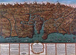
 A historic map of the island of Goa, with an emphasis on the capital city
 -
 Another historic map of the island of Goa, with an emphasis on the capital city
 -
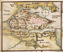
 Topographical Map of the Islands of Goa, with Tiswadi marked in the center as "Ilha de Goa".
 -
 View from a 1630 Portuguese atlas.


References
- ^ Sanjay Subrahmanyam: Three Ways to Be Alien, 2011, Brandeis University Press, pp. 23-24
- ^ Sanjay Subrahmanyam: Three Ways to Be Alien, 2011, Brandeis University Press, pp. 23-24
- ^ Indian Ocean Studies Cultural, Social, and Political Perspectives p. 214.
- ^ "Travel on Panaji-Betim ferry route not to be charged | Goa News - Times of India". The Times of India. 18 January 2020.
- ^ "Ribandar-Chorao ferry ramp nears completion | Goa News - Times of India". The Times of India. TNN. 17 Dec 2019. Retrieved 2021-05-16.
- ^ "How to Reach Divar Island in Goa". India News, Breaking News | India.com. 20 November 2017.
- ^ "56 years on, Goa's oldest ferry-tale comes to an end | Goa News - Times of India". The Times of India. 31 March 2017.
- ^ "Ferry services disrupted for two hours at Gandaulim | Goa News - Times of India". The Times of India. TNN. 21 Aug 2010. Retrieved 2021-05-16.
- ^ "Ferry service on Agassaim-Cortalim route". oHeraldo.
- ^ Times, Navhind (9 July 2016). "Thirty years after Mandovi Bridge collapse".
- ^ "Vehicles on Atal Setu only from February 5 | Goa News - Times of India". The Times of India. 4 February 2019.
- ^ "Gaundalim, Cumbarjua bridges opened for traffic". The Goan EveryDay.
- ^ "Banastari Bridge | IndiaUnveiled". www.indiaunveiled.in.
- ^ "Banastarim bridge work to hit Tiswadi water supply | Goa News - Times of India". The Times of India. TNN. 22 Mar 2021. Retrieved 2021-05-16.
- ^ "Work on new Zuari bridge may start by Sept 2013: Dhavalikar - Times Of India". 2013-01-27. Archived from the original on 27 January 2013. Retrieved 2021-05-16.
- ^ "First section of new Zuari bridge to open in December 2020 | Goa News - Times of India". The Times of India. 20 October 2019.
- ^ "CCP Goa :: City Information". www.ccpgoa.com.
- ^ a b c d e f g h i j k "Siridao Village Population - Tiswadi - North Goa, Goa". Census 2011 India. 29 May 1980. Retrieved 17 November 2016.
Tiswadi
Tissuari | |
|---|---|
Island | |
Tiswadi Tiswadi | |
| Coordinates: 15°28′45.2″N 73°52′54.6″E / 15.479222°N 73.881833°E | |
| Country | |
| State | Goa |
| District | North Goa |
| Taluka | Ilhas |
| Named for | The city of Goa |
| Government | |
| • Type | 7
Panchayats, 13 Communidades |
| Elevation | 8 m (26 ft) |
| Population | |
| • Total | approx. 12,250 |
| Time zone | UTC+5:30 ( IST) |
| Postcode | 403403 |
| Telephone code | 0832 |
Tiswadi (Tissuari in Portuguese) also known as Island of Goa (Ilha de Goa in Portuguese) is the largest estuarine island in the Indian state of Goa and the largest in the Tiswadi Sub-District (Ilhas de Goa in Portuguese). It is situated on the confluence of the Mandovi and Zuari rivers. Due to its name, it is often confused with Ilhas de Goa which means Islands of Goa (plural).
It is one of the of 6 major islands within the Tiswadi Sub-District, on the Mandovi River, the others being:
The island has an area of 166 square kilometers. [1]
Etymology
The island takes its name from "tis wadi" meaning "thirty settlements". [2]
History
The Island of Goa had been a hindu settlement part of the Vijayanagara Empire until the 14th century, when it was incorporated into the Sultanate of Bijapur. [3] In 1510 the island was captured by the second governor of Portuguese India Afonso de Albuquerque, who established it as the capital of Portuguese India for the next 450 years.
Water Bodies
The island is bound by:
- Mandovi River to the north.
- Cumbarjua Canal to the east.
- Zuari River to the south.
- Arabian Sea to the west.
Ferries
Prior to the construction of the bridges, the primary commute to and from the island was done via ferry. Some have become redundant, but most are still in use, they include:
- Panjim to Betim. [4]
- Ribandar to Chorao. [5]
- Ribandar to Divar. [6]
- Old Goa to Divar.
- Daugim to Tolto in St Estevam. [7]
- Gandaulim to Cumbarjua. [8]
- Agaçaim to Cortalim. [9]
Bridges
There are a number of bridges built over the last hundred years, linking the island to other parts of the mainland.
Northern Bridges
These bridges are built over the Mandovi River. They pass through the villages of Penha de França and the city of Panjim:
- 2 Mandovi Bridges: Connects Goa to Bardes. [10]
- Atal Bridge: Connects Goa to Bardes, but avoids the busy roads of Panjim entirely. [11]
Eastern Bridges
These bridges are built over the Cumbarjua Canal.
- Gandaulim Bridge: Connects Gandaulim in Goa to Cumbarjua. [12]
- Banastarim Bridge: Connects Corlim in Goa to Banastarim. [13] [14]
Southern Bridges
These bridges are built over the Zuari River. They pass through the villages of Agaçaim and Cortalim.
- Zuari Bridge: Connects Goa to Mormugão. [15]
- A new Bridge is being constructed (similar in scale to the Atal Bridge) over the Zuari River. [16]
Internal Bridges
These bridges are a link to places within the island, which are geographically close, but are separated by a body of water.
- Ponte Conde de Linhares: This links Panjim to Ribandar, and is the oldest and most famous of all the internal bridges. [17]
Settlements
Cities
| # | City | State | Population |
|---|---|---|---|
| 1 | Panjim Municipal Corporation | Goa | 40000 |
Towns
| # | Town | State | Population (2011) |
|---|---|---|---|
| 1 | Chimbel Census Town | Goa | 15,289 [18] |
| 2 | Calapor or Santa Cruz, Goa Census Town | Goa | 14,077 [18] |
| 4 | Bambolim Census Town | Goa | 6,885 [18] |
| 5 | Corlim Census Town | Goa | 6,568 [18] |
| 6 | Mercurim Census Town | Goa | 4,970 [18] |
| 7 | Cumbarjua Census Town | Goa | 4,917 [18] |
| 8 | Goa Velha Census Town | Goa | 4,322 [18] |
| 9 | Jua Census Town | Goa | 4,134 [18] |
| 10 | Old Goa (Velha Goa) Census Town | Goa | 2,550 [18] |
| 11 | Ribandar Census Town | Goa | 2,450 [18] |
| 12 | Tiswadi Census Town | Goa | 2,300 [18] |
Historical maps
The Island of Goa was depicted on several historic maps.
-
A historic map of the island of Goa, with an emphasis on the capital city
-
Another historic map of the island of Goa, with an emphasis on the capital city
-
Topographical Map of the Islands of Goa, with Tiswadi marked in the center as "Ilha de Goa".
-
View from a 1630 Portuguese atlas.
References
- ^ Sanjay Subrahmanyam: Three Ways to Be Alien, 2011, Brandeis University Press, pp. 23-24
- ^ Sanjay Subrahmanyam: Three Ways to Be Alien, 2011, Brandeis University Press, pp. 23-24
- ^ Indian Ocean Studies Cultural, Social, and Political Perspectives p. 214.
- ^ "Travel on Panaji-Betim ferry route not to be charged | Goa News - Times of India". The Times of India. 18 January 2020.
- ^ "Ribandar-Chorao ferry ramp nears completion | Goa News - Times of India". The Times of India. TNN. 17 Dec 2019. Retrieved 2021-05-16.
- ^ "How to Reach Divar Island in Goa". India News, Breaking News | India.com. 20 November 2017.
- ^ "56 years on, Goa's oldest ferry-tale comes to an end | Goa News - Times of India". The Times of India. 31 March 2017.
- ^ "Ferry services disrupted for two hours at Gandaulim | Goa News - Times of India". The Times of India. TNN. 21 Aug 2010. Retrieved 2021-05-16.
- ^ "Ferry service on Agassaim-Cortalim route". oHeraldo.
- ^ Times, Navhind (9 July 2016). "Thirty years after Mandovi Bridge collapse".
- ^ "Vehicles on Atal Setu only from February 5 | Goa News - Times of India". The Times of India. 4 February 2019.
- ^ "Gaundalim, Cumbarjua bridges opened for traffic". The Goan EveryDay.
- ^ "Banastari Bridge | IndiaUnveiled". www.indiaunveiled.in.
- ^ "Banastarim bridge work to hit Tiswadi water supply | Goa News - Times of India". The Times of India. TNN. 22 Mar 2021. Retrieved 2021-05-16.
- ^ "Work on new Zuari bridge may start by Sept 2013: Dhavalikar - Times Of India". 2013-01-27. Archived from the original on 27 January 2013. Retrieved 2021-05-16.
- ^ "First section of new Zuari bridge to open in December 2020 | Goa News - Times of India". The Times of India. 20 October 2019.
- ^ "CCP Goa :: City Information". www.ccpgoa.com.
- ^ a b c d e f g h i j k "Siridao Village Population - Tiswadi - North Goa, Goa". Census 2011 India. 29 May 1980. Retrieved 17 November 2016.