

Oklahoma is a state located in the Southern United States. According to the 2020 United States Census, Oklahoma is the 28th most populous state with 3,963,516 inhabitants [1] and the 20th largest by land area spanning 69,898 square miles (181,030 km2) of land. [ citation needed] Oklahoma is divided into 77 counties and contains *** incorporated municipalities consisting of *** cities and *** towns. [2] These cities and towns cover only 9.6% of the state's land mass but are home to 60.4% of its population. [3]
The Code of Alabama 1975 defines the legal use of the terms "town" and "city" based on population. A municipality with a population of 2,000 or more is a city, while less than 2,000 is a town. [4] For legislative purposes, municipalities are divided into eight classes based on the municipality's population, as certified by the 1970 federal decennial census. [5] [6] The class of a municipality does not change if its population increases or decreases since the population figures refer to the 1970 federal census. Any municipality incorporated after June 28, 1979 is placed in a class according to the population of the municipality at the time of its incorporation. Class 1 is defined as all cities with a population of at least 300,000, as of the 1970 census. Birmingham is the state's only Class 1 municipality. [7] Class 2 are cities between 175,000 and 299,999 inhabitants, as of the 1970 census. Mobile is the state's only Class 2 municipality. Montgomery and Huntsville are Class 3 municipalities. Class 3 cities are those with populations between 100,000 and 174,999 inhabitants, as of the 1970 census. Tuscaloosa and Gadsden are Class 4 cities with between 50,000 and 99,999 inhabitants, as of the 1970 census. Class 5 are cities with a population greater than 25,000 and less than 49,999. Class 6 are those with between 12,000 and 24,999 inhabitants, and Class 7 are cities with a population from 6,000 to 11,999 inhabitants. Class 8 includes all towns, plus all remaining cities with populations of less than 6,000.
The largest municipality by population is Huntsville with 215,006 residents while the smallest by population is Oak Hill with 14 people. [3] The largest municipality by land area is Huntsville, which spans 209.05 sq mi (541.4 km2), while the smallest is McMullen at 0.11 sq mi (0.28 km2). [3]
List of cities and towns
- Largest cities and towns in Alabama by population
-
 Skyline of Huntsville, Alabama's most populous municipality
 -
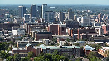 Birmingham is Alabama's second largest municipality by population.
 -
 Alabama State Capitol in Montgomery, Alabama's capital city and third largest city by population
 -
 Skyline of Mobile, Alabama's fourth largest municipality by population
 -
 Downtown area of Tuscaloosa, Alabama's fifth largest municipality by population


‡ State capital and county seat
- ^ Bureau, US Census (April 26, 2021). "2020 Census Apportionment Results". The United States Census Bureau. Retrieved April 27, 2021.
- ^ "Alabama: 2010 Population and Housing Unit Counts 2010 Census of Population and Housing" (PDF). 2010 United States Census. United States Census Bureau. September 2012. p. 19. Retrieved June 17, 2016.
- ^
a
b
c Cite error: The named reference
Census 2010was invoked but never defined (see the help page). - ^ "Code of Alabama - Title 11: Counties and Municipal Corporations - Section 11-40-6 - Municipal corporations classified as cities or towns; holding of election after change in government of municipality". Archived from the original on October 6, 2015. Retrieved December 8, 2015.
- ^ "2018 Alabama Code - Section 11-40-12 — Classification of municipalities". Justia Law. Retrieved 2019-05-29.
- ^ "FAQs from the Alabama Municipal Journal". www.alalm.org. Archived from the original on 2019-07-08. Retrieved 2019-05-29.
- ^ "U.S. Decennial Census". Census.gov. Retrieved May 27, 2013.
Oklahoma is a state located in the Southern United States. According to the 2020 United States Census, Oklahoma is the 28th most populous state with 3,963,516 inhabitants [1] and the 20th largest by land area spanning 69,898 square miles (181,030 km2) of land. [ citation needed] Oklahoma is divided into 77 counties and contains *** incorporated municipalities consisting of *** cities and *** towns. [2] These cities and towns cover only 9.6% of the state's land mass but are home to 60.4% of its population. [3]
The Code of Alabama 1975 defines the legal use of the terms "town" and "city" based on population. A municipality with a population of 2,000 or more is a city, while less than 2,000 is a town. [4] For legislative purposes, municipalities are divided into eight classes based on the municipality's population, as certified by the 1970 federal decennial census. [5] [6] The class of a municipality does not change if its population increases or decreases since the population figures refer to the 1970 federal census. Any municipality incorporated after June 28, 1979 is placed in a class according to the population of the municipality at the time of its incorporation. Class 1 is defined as all cities with a population of at least 300,000, as of the 1970 census. Birmingham is the state's only Class 1 municipality. [7] Class 2 are cities between 175,000 and 299,999 inhabitants, as of the 1970 census. Mobile is the state's only Class 2 municipality. Montgomery and Huntsville are Class 3 municipalities. Class 3 cities are those with populations between 100,000 and 174,999 inhabitants, as of the 1970 census. Tuscaloosa and Gadsden are Class 4 cities with between 50,000 and 99,999 inhabitants, as of the 1970 census. Class 5 are cities with a population greater than 25,000 and less than 49,999. Class 6 are those with between 12,000 and 24,999 inhabitants, and Class 7 are cities with a population from 6,000 to 11,999 inhabitants. Class 8 includes all towns, plus all remaining cities with populations of less than 6,000.
The largest municipality by population is Huntsville with 215,006 residents while the smallest by population is Oak Hill with 14 people. [3] The largest municipality by land area is Huntsville, which spans 209.05 sq mi (541.4 km2), while the smallest is McMullen at 0.11 sq mi (0.28 km2). [3]
List of cities and towns
- Largest cities and towns in Alabama by population
-
Skyline of Huntsville, Alabama's most populous municipality
-
Birmingham is Alabama's second largest municipality by population.
-
Alabama State Capitol in Montgomery, Alabama's capital city and third largest city by population
-
Skyline of Mobile, Alabama's fourth largest municipality by population
-
Downtown area of Tuscaloosa, Alabama's fifth largest municipality by population
‡ State capital and county seat
- ^ Bureau, US Census (April 26, 2021). "2020 Census Apportionment Results". The United States Census Bureau. Retrieved April 27, 2021.
- ^ "Alabama: 2010 Population and Housing Unit Counts 2010 Census of Population and Housing" (PDF). 2010 United States Census. United States Census Bureau. September 2012. p. 19. Retrieved June 17, 2016.
- ^
a
b
c Cite error: The named reference
Census 2010was invoked but never defined (see the help page). - ^ "Code of Alabama - Title 11: Counties and Municipal Corporations - Section 11-40-6 - Municipal corporations classified as cities or towns; holding of election after change in government of municipality". Archived from the original on October 6, 2015. Retrieved December 8, 2015.
- ^ "2018 Alabama Code - Section 11-40-12 — Classification of municipalities". Justia Law. Retrieved 2019-05-29.
- ^ "FAQs from the Alabama Municipal Journal". www.alalm.org. Archived from the original on 2019-07-08. Retrieved 2019-05-29.
- ^ "U.S. Decennial Census". Census.gov. Retrieved May 27, 2013.