Photos • Location
| Neretva Неретва | |
|---|---|
 | |
 Neretva +
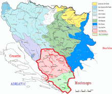
Trebišnjica watershed (in Bosnia-Herzegovina highlighted in red and green) | |
| Etymology | of Illyrian origin, from Indo-European base *ner-, *nor- "to dive, dip, immerse" |
| Location | |
| Countries | |
| Towns | |
| Physical characteristics | |
| Source | |
| • location | Lebršnik and Zelengora Mountains, Dinaric Alps, Bosnia and Herzegovina |
| • coordinates | 43°16′18″N 18°33′27″E / 43.271619°N 18.557508°E |
| • elevation | 1,227 m (4,026 ft) |
| Mouth | Adriatic Sea |
• location | Ploče, Croatia |
• coordinates | 43°01′17″N 17°26′54″E / 43.021385°N 17.448328°E |
• elevation | 0 m (0 ft) |
| Length | 225 km (140 mi) [1] |
| Basin size | 11,798 km2 (4,555 sq mi) [1] |
| Discharge | |
| • average | 341 m3/s (12,000 cu ft/s) |
| Basin features | |
| Progression | Neretva→ Adriatic Sea |
| River system | Adriatic |
| Tributaries | |
| • left | Mostarska Bijela, Buna, Bregava, Krupa |
| • right | Rakitnica, Rama, Trebižat |
| Waterbodies | Uloško Lake, Boračko jezero, Blatačko Lake, Jablaničko Lake, Ramsko Lake, Salakovačko Lake, Grabovičko Lake, Mostarsko Lake, Hutovo Blato, Vrutak, Neretva Delta |
| Bridges | Stara Ćuprija, Stari Most |
| Inland ports | Metković |
- ^ a b Statistical Yearbook of the Republic of Croatia 2017 (PDF) (in Croatian and English). Zagreb: Croatian Bureau of Statistics. December 2017. p. 47. ISSN 1333-3305. Archived from the original (PDF) on 13 November 2018. Retrieved 23 May 2018.
| Neretva Неретва | |
|---|---|
 | |
 Neretva +
Trebišnjica watershed (in Bosnia-Herzegovina highlighted in red and green) | |
| Etymology | of Illyrian origin, from Indo-European base *ner-, *nor- "to dive, dip, immerse" |
| Location | |
| Countries | |
| Towns | |
| Physical characteristics | |
| Source | |
| • location | Lebršnik and Zelengora Mountains, Dinaric Alps, Bosnia and Herzegovina |
| • coordinates | 43°16′18″N 18°33′27″E / 43.271619°N 18.557508°E |
| • elevation | 1,227 m (4,026 ft) |
| Mouth | Adriatic Sea |
• location | Ploče, Croatia |
• coordinates | 43°01′17″N 17°26′54″E / 43.021385°N 17.448328°E |
• elevation | 0 m (0 ft) |
| Length | 225 km (140 mi) [1] |
| Basin size | 11,798 km2 (4,555 sq mi) [1] |
| Discharge | |
| • average | 341 m3/s (12,000 cu ft/s) |
| Basin features | |
| Progression | Neretva→ Adriatic Sea |
| River system | Adriatic |
| Tributaries | |
| • left | Mostarska Bijela, Buna, Bregava, Krupa |
| • right | Rakitnica, Rama, Trebižat |
| Waterbodies | Uloško Lake, Boračko jezero, Blatačko Lake, Jablaničko Lake, Ramsko Lake, Salakovačko Lake, Grabovičko Lake, Mostarsko Lake, Hutovo Blato, Vrutak, Neretva Delta |
| Bridges | Stara Ćuprija, Stari Most |
| Inland ports | Metković |
- ^ a b Statistical Yearbook of the Republic of Croatia 2017 (PDF) (in Croatian and English). Zagreb: Croatian Bureau of Statistics. December 2017. p. 47. ISSN 1333-3305. Archived from the original (PDF) on 13 November 2018. Retrieved 23 May 2018.

