
-
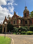
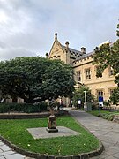
 Clocktower at the Old Arts Building, viewed from South Lawn
 -
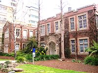
 1888 Building, home to the Graduate Student Association
 -
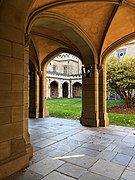
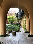 Arts West colonnade, 2018
 -
 Melbourne School of Design, which incorporates the relocated facade of a Collins Street bank
 -
 View down the colonnade on the Northern section of the Old Quad, the first building at the University of Melbourne
 -
 Melba Hall and Conservatorium of Music
 -
 Newman College Chapel
 -
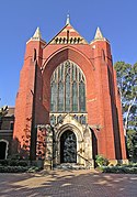 Trinity College Chapel
 -
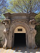 Entrance to South Lawn car park, originally from the Colonial Bank of Australasia headquarters in Melbourne city centre
 -
 Ian Potter Museum of Art, Swanston St
 -
 Cussonia Court
 -
 Southern colonnade, Old Quad
 -
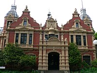
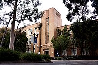
 Botany Building (1928). Parkville Campus of The University of Melbourne
 -
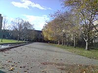
 University of Melbourne in Autumn
 -
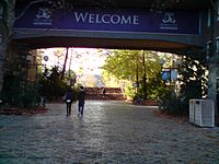
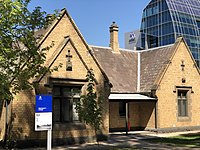 Gatekeeper's Cottage on Grattan Street
Photos • Location


| Line | First Service | Image | Length | Stations | Rolling stock | |
|---|---|---|---|---|---|---|
| Airport line | 2001 |

|
15.9 km (9.9 mi) | 2 (Branch) | ||
| Gold Coast line | 1996 |

|
20 |
| ||
| Beenleigh line | 1881 (Electrified 1982-4) |
.jpg)
|
41.5 km (25.8 mi) | 22 |
| |
| Ferny Grove line | 1899 (Electrified 1979) |

|
13.5 km (8.4 mi) | 11 |
| |
| Caboolture line | 1888 (Electrified 1982-6) |

|
49.6 km (30.8 mi) | 13 |
| |
| Ipswich and Rosewood line | 1876 (Electrified 1979-93) |

|
57 km (35 mi) | 32 | ||
| Sunshine Coast line | 1881 (Electrified 1988) |

|
180 km (110 mi) | 29 | ||
| Cleveland line | 1888 (Electrified 1982-8) |

|
37.3 km (23.2 mi) | 25 |
| |
| Shorncliffe line | 1882 (Electrified 1982) |

|
11 km (6.8 mi) | 18 | ||
| Redcliffe Peninsula line | 2016 |

|
12 km (7.5 mi) | 6 (Branch) | ||
| Springfield line | 2013 |

|
13.6 km (8.5 mi) | 4 (Branch) | ||
| Doomben line | 1882 (Electrified 1988) |

|
8 km (5.0 mi) | 11 |
| |
| Exhibition line | 1882 (Electrified 1982) |

|
3.4 km (2.1 mi) | 1 (Branch) |
| |
| Line | First Service | Image | Length | Stations | Rolling stock | |
|---|---|---|---|---|---|---|
| Fremantle line | 1881 (Electrified 1991) |

|
19 km (12 mi) | 17 | ||
| Midland line | 1881 (Electrified 1991) |

|
16.1 km (10.0 mi) | 15 |
| |
| Armadale line | 1893 (Electrified 1991) |

|
30.4 km (18.9 mi) | 21 |
| |
| Joondalup line | 1992 |

|
40.7 km (25.3 mi) | 13 |
| |
| Thornlie line | 2004 |

|
Branch: 2.9 km (1.8 mi)
Total: 25.2 km (15.7 mi) |
Branch: 1
Total: 11 |
| |
| Mandurah line | 2007 |

|
70.1 km (43.6 mi) | 12 |
| |
| Airport line | 2022 |

|
Branch: 8.6 km (5.3 mi)
Total: 25.2 km (15.7 mi) |
Branch: 3
Total: 11 |
| |
| Ellenbrook line | 2024 (Planned) |

|
Branch: 21 km (13 mi) | Branch: 5
Total: 13 |
||
Melbourne
Naarm | |
|---|---|
  .jpg) .jpg) .jpg) .jpg) From top; left to right:
Melbourne CBD;
Flinders Street Station,
Shrine of Remembrance,
Melbourne Cricket Ground,
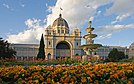
Royal Exhibition Building,
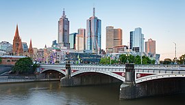
Princes Bridge with
St Paul's Cathedral. | |
 Melbourne | |
| Coordinates: 37°48′51″S 144°57′47″E / 37.81417°S 144.96306°E | |
| Country | Australia |
| State | Victoria |
| Local government area | 31 Municipalities across Greater Melbourne |
| First settled | 1835 |
| Government | |
| • Type | Executive mayoralty and deliberative assembly within unitary constitutional monarchy |
| • Body |
Greater London Authority • Mayor Sadiq Khan ( L) • London Assembly |
| • London Assembly | 14 constituencies |
| • UK Parliament | 73 constituencies |
| Area | |
| • Total [A] | 1,572.03 km2 (606.96 sq mi) |
| • Urban | 1,737.9 km2 (671.0 sq mi) |
| • Metro | 8,382 km2 (3,236 sq mi) |
| • City of London | 2.89 km2 (1.12 sq mi) |
| • 32 London boroughs (total) | 1,569.14 km2 (605.85 sq mi) |
| Elevation | 11 m (36 ft) |
| Population (2021 except where stated) | |
| • Total [A] | 8,799,800 [1] |
| • Density | 5,598/km2 (14,500/sq mi) |
| •
Urban (2011)
[3] | 9,787,426 |
| •
Metro (2019)
[4] | 14,257,962 ( London metropolitan area) |
| • City of London | 8,600 [1] |
| Demonyms | Melburnian |
| GVA (2020) | |
| • Total | £504 billion |
| • Per capita | £55,974 |
| Time zone | UTC ( Greenwich Mean Time) |
| • Summer ( DST) | UTC+1 ( British Summer Time) |
| Postcode areas | |
| Area codes |
|
| Budget | £19.376 billion ($25 billion) [6] |
| International airports | Inside London: Heathrow ( LHR) City ( LCY) Outside London: Gatwick ( LGW) Stansted ( STN) Luton ( LTN) Southend ( SEN) |
| Public transport systems | Yarra Trams, Melbourne Metro |
| Police |
Metropolitan (county of Greater London) City of London ( City of London square mile) |
| Ambulance | London |
| Fire | London |
| GeoTLD | .london |
| Melbourne Narrm
Victoria | |||||||||
|---|---|---|---|---|---|---|---|---|---|
From top; left to right:
Melbourne CBD;
Flinders Street Station,
Shrine of Remembrance,
Melbourne Cricket Ground,
Royal Exhibition Building,
Princes Bridge with
St Paul's Cathedral. | |||||||||
 Map of Melbourne, Australia, printable and editable | |||||||||
Melbourne | |||||||||
| Coordinates | 37°48′51″S 144°57′47″E / 37.81417°S 144.96306°E | ||||||||
| Population | 4,917,750 (2021) [8] ( 2nd) | ||||||||
| • Density | 492.119/km2 (1,274.58/sq mi) | ||||||||
| Established | 30 August 1835 | ||||||||
| Elevation | 31 m (102 ft) | ||||||||
| Area | 9,993 km2 (3,858.3 sq mi)(GCCSA) [9] | ||||||||
| Time zone | AEST ( UTC+10) | ||||||||
| • Summer ( DST) | AEDT ( UTC+11) | ||||||||
| Location | |||||||||
| LGA(s) | 31 Municipalities across Greater Melbourne | ||||||||
| County | Grant, Bourke, Mornington | ||||||||
| State electorate(s) | 55 electoral districts and regions | ||||||||
| Federal division(s) | 23 Divisions | ||||||||
 | |||||||||
-37.8979,145.1136 -37.8979,145.1136 -37.8917,145.1026
SRL green: #008746
Hurstbridge
-37.7337/145.0825
SRL map
Main map
Interactive map showing suburban lines of the Melbourne metropolitan rail network, including the under construction
Metro Tunnel in grey.
| Major expansions and upgrades | ||||||
|---|---|---|---|---|---|---|
| Project | Stage | Start date | Completion date | Length | Stations | Description |
| Metro Tunnel | 2016 | 2025 | 9 km | 5 | New CBD tunnel | |
| Melbourne Airport Rail | 2022 | 2029 | 20 km | 2 | Metro line to Melbourne Airport | |
| Suburban Rail Loop (SRL) | 1: SRL East | 2022 | 2035 | 28 km | 6 | Cheltenham to Box Hill |
| 2: SRL North | TBD | 2043-50 | 32 km | 8 | Box Hill to Melbourne Airport | |
| 3: SRL West | TBD | TBD | TBD | TBD | Sunshine to Werribee | |
| Level Crossing Removal Project | 2016 | 2030 | N/A | 51 station rebuilds | 110 level crossing removals | |
| Short extensions and infill stations | ||||||
| Pakenham East extension | 2021 | 2024 | 2 km | 1 | New station at Pakenham East [15] | |
| New Deer Park-West Werribee line infill stations | TBD | TBD | N/A | 2 | Infill stations at Tarneit West and Truganina [16] | |
.jpg)
.jpg)
From top, left to right: Melbourne skyline, Flinders Street Station, Shrine of Remembrance, Melbourne Cricket Ground, Royal Exhibition Building, Princes Bridge with Federation Square and St Paul's Cathedral.
North East Link
University of Melbourne gallery


.jpg)


.jpg)
.jpg)


-
Ian Potter Museum of Art
-
Melba Hall and Conservatorium of Music
-
The Old Commerce building combines the relocated facade of a Collins Street bank with a 1930s building
-
 The cloisters of the Old Quad
 -
 1888 building
 -
Newman College Chapel
-
The Chapel of Trinity College
-
Entrance to South Lawn car park, originally part of the entrance to the Colonial Bank of Australasia headquarters building in the Melbourne city centre
-
 South Lawn
 -
 The Grattan Street main entrance
 -
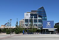 Alan Gilbert Building, University of Melbourne in Carlton
 -
 Older buildings in the foreground, with newer buildings in the background
 -
Botany Building (1928). Parkville Campus of The University of Melbourne
-
University of Melbourne in autumn
-
 Chemistry School Building


.jpg)
Colleges
| Colleges | |||
|---|---|---|---|
|
Trinity College 1872–present  |
Ormond College 1881–present .jpg) |
Janet Clarke Hall 1886–present .jpg) |
St Mary's College 1918–present .jpg)
|
|
Queen's College 1887–present .jpg) |
Newman College 1918–present  |
Medley Hall 1954–present 
| |
| Whitley College, 1965–present | |||
| Ridley College, 1910–2007 | |||
| University College, 1937–present | |||
| International House, 1957–present | |||
| Graduate House, 1962–present | |||
| St Hilda's College, 1964–present |
Gallery
Melbourne level crossing removals
-
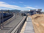
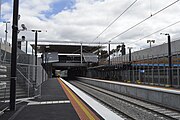
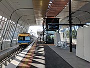 Rebuilt elevated Noble Park railway station, February 2018
 -
 Rebuilt Hughesdale railway station, April 2019
 -
 Street level view of the rebuilt Bentleigh railway station, 2018
 -
 Platform view of the lowered Bentleigh railway station, 2018
 -
 The rebuilt Bayswater railway station soon after the removal of the Mountain Highway level crossing.
 -
 Platform view of the lowered Bayswater railway station, July 2017
 -
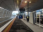
 The entrance of Heatherdale railway station in the final stages of construction, 2017
 -
 Looking East at the lowered Heatherdale railway station during construction, February 2017
 -
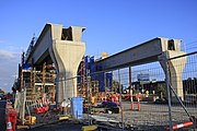 Construction of elevated rail at Clayton railway station for the level crossing removal, September 2017
 -
 Rebuilt elevated Clayton railway station, April 2018
 -
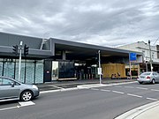
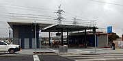
 The rebuilt St Albans railway station on the day it reopened, November 2016
 -
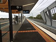
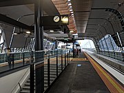
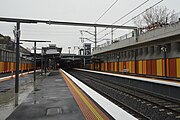
 Rebuilt Carnegie railway station, 2018
 -
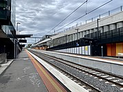
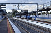
 Platform view of the lowered Ormond railway station, August 2016
 -
 Platform view of partially rebuilt Rosanna railway station, May 2018


.jpg)


.jpg)


Yarra River map
Q695081
map=10/-37.8244/145.5270
Melbourne Metropolitan Train Network and V/Line Interactive Map (v03)
Melbourne Metropolitan Suburban Rail Network Interactive Map (v01)
Melbourne Metropolitan Train Network Interactive Map (v02 metro tunnel lower, with Stony Point)
Interactive Map showing Metro Tunnel
Stony Point line
-38.2589/145.1737
Hurstbridge line
-37.7337/145.0825
-37.8474/145.0748
Alamein line
Belgrave line -37.8459/145.1648 -37.8675/145.1675
-37.7916/145.1490
Glen Waverley -37.8571/145.0602
Frankston line -37.9791/145.0590
-38.0089/145.0666
Pakenham line -37.9921/145.2327 -37.9423/145.2245
Cranbourne line -37.9721/145.1757 -37.9607/145.1730
Sandringham -37.8899/144.9891
Werribee -37.8355/144.8668 -37.8756 Longitude 144.7734
Williamstown -37.8363/144.9180
Sunbury -37.7004/144.8372
Upfield line -37.7527/144.9576
Craigieburn line -37.7540/144.9284
Mernda line -37.7428/145.0144
---
From top, left to right: Melbourne's eastern CBD behind
Princes Bridge,
Flinders Street Station, Tram on
Bourke St,
Melbourne Cricket Ground,
Royal Exhibition Building, Melbourne's skyline from the
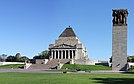
Shrine of Remembrance.
New 2018 montage of Melbourne
Images from top, left to right:
- Melbourne's eastern skyline from Southbank File:City of Melbourne skyline from Southbank with Princes Bridge and St Pauls, 2018.jpg Author, Gracchus250
- Flinders Street Station from File:1 flinders st station melb.jpg Author, Adam.J.W.C.
- Tram on Bourke St from File:C2.5113 bourke, 2014(3).jpg Author, Bahnfrend
- Melbourne Cricket Ground from File:2017 AFL Grand Final panorama during national anthem.jpg Author, Flickerd
- Royal Exhibition Building from File:Royal_exhibition_building_tulips_straight.jpg Author, Photograph taken by [[User:Diliff and straightened by Ikiwaner
- Royal Botanic Gardens of Victoria File:RBGV MG Ornamental Lake2017.jpg Author, Adrian Vittorio
.jpg)
- ^ a b "Population and household estimates, England and Wales: Census 2021". ons.gov.uk. Office for National Statistics. Retrieved 15 October 2022.
- ^ "London weather map". The Met Office. Archived from the original on 3 August 2018. Retrieved 26 August 2018.
- ^ "2011 Census – Built-up areas". ONS. Retrieved 15 October 2022.
- ^ "Metropolitan Area Populations". Eurostat. 18 June 2019. Retrieved 4 December 2019.
- ^ Fenton, Trevor. "Regional economic activity by gross domestic product, UK: 1998 to 2020". ons.gov.uk.
- ^ "The Greater London Authority Consolidated Budget and Component Budgets for 2021–22" (PDF).
- ^ Sub-national HDI. "Area Database – Global Data Lab". hdi.globaldatalab.org.
- ^ "Greater Melbourne". Australian Bureau of Statistics. Archived from the original on 29 June 2022. Retrieved 29 June 2022.
- ^ "2016 Census of Population and Housing: General Community Profile". Australian Bureau of Statistics. 2017. Archived from the original on 17 August 2021. Retrieved 28 September 2021.
- ^ "Great Circle Distance between MELBOURNE and CANBERRA". Geoscience Australia. March 2004. Archived from the original on 4 June 2022. Retrieved 19 December 2016.
- ^ "Great Circle Distance between MELBOURNE and ADELAIDE". Geoscience Australia. March 2004. Archived from the original on 4 June 2022. Retrieved 19 December 2016.
- ^ "Great Circle Distance between MELBOURNE and SYDNEY". Geoscience Australia. March 2004.
- ^ "Great Circle Distance between MELBOURNE and BRISBANE". Geoscience Australia. March 2004. Archived from the original on 20 December 2016. Retrieved 19 December 2016.
- ^ "Great Circle Distance between MELBOURNE and PERTH". Geoscience Australia. March 2004. Archived from the original on 20 December 2016. Retrieved 19 December 2016.
- ^ Build, Victoria’s Big (2021-02-18). "New Pakenham East station location announced and 3 more sets of boom gates to go". Victoria’s Big Build. Retrieved 2023-01-14.
- ^ "Delivering New Stations For The West | Premier of Victoria". www.premier.vic.gov.au. Retrieved 2023-01-14.
Cite error: There are <ref group=upper-alpha> tags or {{efn-ua}} templates on this page, but the references will not show without a {{reflist|group=upper-alpha}} template or {{notelist-ua}} template (see the
help page).
| Line | First Service | Image | Length | Stations | Rolling stock | |
|---|---|---|---|---|---|---|
| Airport line | 2001 |
|
15.9 km (9.9 mi) | 2 (Branch) | ||
| Gold Coast line | 1996 |
|
20 |
| ||
| Beenleigh line | 1881 (Electrified 1982-4) |
|
41.5 km (25.8 mi) | 22 |
| |
| Ferny Grove line | 1899 (Electrified 1979) |
|
13.5 km (8.4 mi) | 11 |
| |
| Caboolture line | 1888 (Electrified 1982-6) |
|
49.6 km (30.8 mi) | 13 |
| |
| Ipswich and Rosewood line | 1876 (Electrified 1979-93) |
|
57 km (35 mi) | 32 | ||
| Sunshine Coast line | 1881 (Electrified 1988) |
|
180 km (110 mi) | 29 | ||
| Cleveland line | 1888 (Electrified 1982-8) |
|
37.3 km (23.2 mi) | 25 |
| |
| Shorncliffe line | 1882 (Electrified 1982) |
|
11 km (6.8 mi) | 18 | ||
| Redcliffe Peninsula line | 2016 |
|
12 km (7.5 mi) | 6 (Branch) | ||
| Springfield line | 2013 |
|
13.6 km (8.5 mi) | 4 (Branch) | ||
| Doomben line | 1882 (Electrified 1988) |
|
8 km (5.0 mi) | 11 |
| |
| Exhibition line | 1882 (Electrified 1982) |
|
3.4 km (2.1 mi) | 1 (Branch) |
| |
| Line | First Service | Image | Length | Stations | Rolling stock | |
|---|---|---|---|---|---|---|
| Fremantle line | 1881 (Electrified 1991) |
|
19 km (12 mi) | 17 | ||
| Midland line | 1881 (Electrified 1991) |
|
16.1 km (10.0 mi) | 15 |
| |
| Armadale line | 1893 (Electrified 1991) |
|
30.4 km (18.9 mi) | 21 |
| |
| Joondalup line | 1992 |
|
40.7 km (25.3 mi) | 13 |
| |
| Thornlie line | 2004 |
|
Branch: 2.9 km (1.8 mi)
Total: 25.2 km (15.7 mi) |
Branch: 1
Total: 11 |
| |
| Mandurah line | 2007 |
|
70.1 km (43.6 mi) | 12 |
| |
| Airport line | 2022 |
|
Branch: 8.6 km (5.3 mi)
Total: 25.2 km (15.7 mi) |
Branch: 3
Total: 11 |
| |
| Ellenbrook line | 2024 (Planned) |
|
Branch: 21 km (13 mi) | Branch: 5
Total: 13 |
||
Melbourne
Naarm | |
|---|---|
From top; left to right:
Melbourne CBD;
Flinders Street Station,
Shrine of Remembrance,
Melbourne Cricket Ground,
Royal Exhibition Building,
Princes Bridge with
St Paul's Cathedral. | |
Melbourne | |
| Coordinates: 37°48′51″S 144°57′47″E / 37.81417°S 144.96306°E | |
| Country | Australia |
| State | Victoria |
| Local government area | 31 Municipalities across Greater Melbourne |
| First settled | 1835 |
| Government | |
| • Type | Executive mayoralty and deliberative assembly within unitary constitutional monarchy |
| • Body |
Greater London Authority • Mayor Sadiq Khan ( L) • London Assembly |
| • London Assembly | 14 constituencies |
| • UK Parliament | 73 constituencies |
| Area | |
| • Total [A] | 1,572.03 km2 (606.96 sq mi) |
| • Urban | 1,737.9 km2 (671.0 sq mi) |
| • Metro | 8,382 km2 (3,236 sq mi) |
| • City of London | 2.89 km2 (1.12 sq mi) |
| • 32 London boroughs (total) | 1,569.14 km2 (605.85 sq mi) |
| Elevation | 11 m (36 ft) |
| Population (2021 except where stated) | |
| • Total [A] | 8,799,800 [1] |
| • Density | 5,598/km2 (14,500/sq mi) |
| •
Urban (2011)
[3] | 9,787,426 |
| •
Metro (2019)
[4] | 14,257,962 ( London metropolitan area) |
| • City of London | 8,600 [1] |
| Demonyms | Melburnian |
| GVA (2020) | |
| • Total | £504 billion |
| • Per capita | £55,974 |
| Time zone | UTC ( Greenwich Mean Time) |
| • Summer ( DST) | UTC+1 ( British Summer Time) |
| Postcode areas | |
| Area codes |
|
| Budget | £19.376 billion ($25 billion) [6] |
| International airports | Inside London: Heathrow ( LHR) City ( LCY) Outside London: Gatwick ( LGW) Stansted ( STN) Luton ( LTN) Southend ( SEN) |
| Public transport systems | Yarra Trams, Melbourne Metro |
| Police |
Metropolitan (county of Greater London) City of London ( City of London square mile) |
| Ambulance | London |
| Fire | London |
| GeoTLD | .london |
| Melbourne Narrm
Victoria | |||||||||
|---|---|---|---|---|---|---|---|---|---|
From top; left to right:
Melbourne CBD;
Flinders Street Station,
Shrine of Remembrance,
Melbourne Cricket Ground,
Royal Exhibition Building,
Princes Bridge with
St Paul's Cathedral. | |||||||||
|
Map of Melbourne, Australia, printable and editable | |||||||||
Melbourne | |||||||||
| Coordinates | 37°48′51″S 144°57′47″E / 37.81417°S 144.96306°E | ||||||||
| Population | 4,917,750 (2021) [8] ( 2nd) | ||||||||
| • Density | 492.119/km2 (1,274.58/sq mi) | ||||||||
| Established | 30 August 1835 | ||||||||
| Elevation | 31 m (102 ft) | ||||||||
| Area | 9,993 km2 (3,858.3 sq mi)(GCCSA) [9] | ||||||||
| Time zone | AEST ( UTC+10) | ||||||||
| • Summer ( DST) | AEDT ( UTC+11) | ||||||||
| Location | |||||||||
| LGA(s) | 31 Municipalities across Greater Melbourne | ||||||||
| County | Grant, Bourke, Mornington | ||||||||
| State electorate(s) | 55 electoral districts and regions | ||||||||
| Federal division(s) | 23 Divisions | ||||||||
|
| |||||||||
| |||||||||
-37.8979,145.1136 -37.8979,145.1136 -37.8917,145.1026
SRL green: #008746
Hurstbridge
-37.7337/145.0825
SRL map
Main map
Interactive map showing suburban lines of the Melbourne metropolitan rail network, including the under construction
Metro Tunnel in grey.
| Major expansions and upgrades | ||||||
|---|---|---|---|---|---|---|
| Project | Stage | Start date | Completion date | Length | Stations | Description |
| Metro Tunnel | 2016 | 2025 | 9 km | 5 | New CBD tunnel | |
| Melbourne Airport Rail | 2022 | 2029 | 20 km | 2 | Metro line to Melbourne Airport | |
| Suburban Rail Loop (SRL) | 1: SRL East | 2022 | 2035 | 28 km | 6 | Cheltenham to Box Hill |
| 2: SRL North | TBD | 2043-50 | 32 km | 8 | Box Hill to Melbourne Airport | |
| 3: SRL West | TBD | TBD | TBD | TBD | Sunshine to Werribee | |
| Level Crossing Removal Project | 2016 | 2030 | N/A | 51 station rebuilds | 110 level crossing removals | |
| Short extensions and infill stations | ||||||
| Pakenham East extension | 2021 | 2024 | 2 km | 1 | New station at Pakenham East [15] | |
| New Deer Park-West Werribee line infill stations | TBD | TBD | N/A | 2 | Infill stations at Tarneit West and Truganina [16] | |
From top, left to right: Melbourne skyline, Flinders Street Station, Shrine of Remembrance, Melbourne Cricket Ground, Royal Exhibition Building, Princes Bridge with Federation Square and St Paul's Cathedral.
North East Link
University of Melbourne gallery
-
Clocktower at the Old Arts Building, viewed from South Lawn
-
1888 Building, home to the Graduate Student Association
-
Arts West colonnade, 2018
-
Melbourne School of Design, which incorporates the relocated facade of a Collins Street bank
-
View down the colonnade on the Northern section of the Old Quad, the first building at the University of Melbourne
-
Melba Hall and Conservatorium of Music
-
Newman College Chapel
-
Trinity College Chapel
-
Entrance to South Lawn car park, originally from the Colonial Bank of Australasia headquarters in Melbourne city centre
-
Ian Potter Museum of Art, Swanston St
-
Cussonia Court
-
Southern colonnade, Old Quad
-
Botany Building (1928). Parkville Campus of The University of Melbourne
-
University of Melbourne in Autumn
-
Gatekeeper's Cottage on Grattan Street
-
Ian Potter Museum of Art
-
Melba Hall and Conservatorium of Music
-
The Old Commerce building combines the relocated facade of a Collins Street bank with a 1930s building
-
The cloisters of the Old Quad
-
1888 building
-
Newman College Chapel
-
The Chapel of Trinity College
-
Entrance to South Lawn car park, originally part of the entrance to the Colonial Bank of Australasia headquarters building in the Melbourne city centre
-
South Lawn
-
The Grattan Street main entrance
-
Alan Gilbert Building, University of Melbourne in Carlton
-
Older buildings in the foreground, with newer buildings in the background
-
Botany Building (1928). Parkville Campus of The University of Melbourne
-
University of Melbourne in autumn
-
Chemistry School Building
Colleges
| Colleges | |||
|---|---|---|---|
|
Trinity College 1872–present |
Ormond College 1881–present |
Janet Clarke Hall 1886–present |
St Mary's College 1918–present
|
|
Queen's College 1887–present |
Newman College 1918–present |
Medley Hall 1954–present
| |
| Whitley College, 1965–present | |||
| Ridley College, 1910–2007 | |||
| University College, 1937–present | |||
| International House, 1957–present | |||
| Graduate House, 1962–present | |||
| St Hilda's College, 1964–present |
Gallery
Melbourne level crossing removals
-
Rebuilt elevated Noble Park railway station, February 2018
-
Rebuilt Hughesdale railway station, April 2019
-
Street level view of the rebuilt Bentleigh railway station, 2018
-
Platform view of the lowered Bentleigh railway station, 2018
-
The rebuilt Bayswater railway station soon after the removal of the Mountain Highway level crossing.
-
Platform view of the lowered Bayswater railway station, July 2017
-
The entrance of Heatherdale railway station in the final stages of construction, 2017
-
Looking East at the lowered Heatherdale railway station during construction, February 2017
-
Construction of elevated rail at Clayton railway station for the level crossing removal, September 2017
-
Rebuilt elevated Clayton railway station, April 2018
-
The rebuilt St Albans railway station on the day it reopened, November 2016
-
Rebuilt Carnegie railway station, 2018
-
Platform view of the lowered Ormond railway station, August 2016
-
Platform view of partially rebuilt Rosanna railway station, May 2018
Yarra River map
Q695081
map=10/-37.8244/145.5270
Melbourne Metropolitan Train Network and V/Line Interactive Map (v03)
Melbourne Metropolitan Suburban Rail Network Interactive Map (v01)
Melbourne Metropolitan Train Network Interactive Map (v02 metro tunnel lower, with Stony Point)
Interactive Map showing Metro Tunnel
Stony Point line
-38.2589/145.1737
Hurstbridge line
-37.7337/145.0825
-37.8474/145.0748
Alamein line
Belgrave line -37.8459/145.1648 -37.8675/145.1675
-37.7916/145.1490
Glen Waverley -37.8571/145.0602
Frankston line -37.9791/145.0590
-38.0089/145.0666
Pakenham line -37.9921/145.2327 -37.9423/145.2245
Cranbourne line -37.9721/145.1757 -37.9607/145.1730
Sandringham -37.8899/144.9891
Werribee -37.8355/144.8668 -37.8756 Longitude 144.7734
Williamstown -37.8363/144.9180
Sunbury -37.7004/144.8372
Upfield line -37.7527/144.9576
Craigieburn line -37.7540/144.9284
Mernda line -37.7428/145.0144
---
From top, left to right: Melbourne's eastern CBD behind
Princes Bridge,
Flinders Street Station, Tram on
Bourke St,
Melbourne Cricket Ground,
Royal Exhibition Building, Melbourne's skyline from the
Shrine of Remembrance.
New 2018 montage of Melbourne
Images from top, left to right:
- Melbourne's eastern skyline from Southbank File:City of Melbourne skyline from Southbank with Princes Bridge and St Pauls, 2018.jpg Author, Gracchus250
- Flinders Street Station from File:1 flinders st station melb.jpg Author, Adam.J.W.C.
- Tram on Bourke St from File:C2.5113 bourke, 2014(3).jpg Author, Bahnfrend
- Melbourne Cricket Ground from File:2017 AFL Grand Final panorama during national anthem.jpg Author, Flickerd
- Royal Exhibition Building from File:Royal_exhibition_building_tulips_straight.jpg Author, Photograph taken by [[User:Diliff and straightened by Ikiwaner
- Royal Botanic Gardens of Victoria File:RBGV MG Ornamental Lake2017.jpg Author, Adrian Vittorio
- ^ a b "Population and household estimates, England and Wales: Census 2021". ons.gov.uk. Office for National Statistics. Retrieved 15 October 2022.
- ^ "London weather map". The Met Office. Archived from the original on 3 August 2018. Retrieved 26 August 2018.
- ^ "2011 Census – Built-up areas". ONS. Retrieved 15 October 2022.
- ^ "Metropolitan Area Populations". Eurostat. 18 June 2019. Retrieved 4 December 2019.
- ^ Fenton, Trevor. "Regional economic activity by gross domestic product, UK: 1998 to 2020". ons.gov.uk.
- ^ "The Greater London Authority Consolidated Budget and Component Budgets for 2021–22" (PDF).
- ^ Sub-national HDI. "Area Database – Global Data Lab". hdi.globaldatalab.org.
- ^ "Greater Melbourne". Australian Bureau of Statistics. Archived from the original on 29 June 2022. Retrieved 29 June 2022.
- ^ "2016 Census of Population and Housing: General Community Profile". Australian Bureau of Statistics. 2017. Archived from the original on 17 August 2021. Retrieved 28 September 2021.
- ^ "Great Circle Distance between MELBOURNE and CANBERRA". Geoscience Australia. March 2004. Archived from the original on 4 June 2022. Retrieved 19 December 2016.
- ^ "Great Circle Distance between MELBOURNE and ADELAIDE". Geoscience Australia. March 2004. Archived from the original on 4 June 2022. Retrieved 19 December 2016.
- ^ "Great Circle Distance between MELBOURNE and SYDNEY". Geoscience Australia. March 2004.
- ^ "Great Circle Distance between MELBOURNE and BRISBANE". Geoscience Australia. March 2004. Archived from the original on 20 December 2016. Retrieved 19 December 2016.
- ^ "Great Circle Distance between MELBOURNE and PERTH". Geoscience Australia. March 2004. Archived from the original on 20 December 2016. Retrieved 19 December 2016.
- ^ Build, Victoria’s Big (2021-02-18). "New Pakenham East station location announced and 3 more sets of boom gates to go". Victoria’s Big Build. Retrieved 2023-01-14.
- ^ "Delivering New Stations For The West | Premier of Victoria". www.premier.vic.gov.au. Retrieved 2023-01-14.
Cite error: There are <ref group=upper-alpha> tags or {{efn-ua}} templates on this page, but the references will not show without a {{reflist|group=upper-alpha}} template or {{notelist-ua}} template (see the
help page).