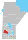
Division No. 17, Unorganized is a Statistics Canada census subdivision of its Division No. 17, Manitoba, that consists of a part of the division that is not organized into either incorporated municipalities or Indian reserves.
Geography
According to Statistics Canada, the census subdivision has a population of 101 (in 2011) and an area of 2,169.59 km2. [1]
See also
References
51°15′58″N 100°00′25″W / 51.266°N 100.007°W
