| Tuzkol | |
|---|---|
| Тұзкөл | |
 View of the lake | |
 Tuzkol | |
| Location | Kegen Depression |
| Coordinates | 43°00′N 79°58′E / 43.000°N 79.967°E |
| Type | salt lake |
| Basin countries | Kazakhstan |
| Max. length | 5.7 kilometers (3.5 mi) |
| Max. width | 2.1 kilometers (1.3 mi) |
| Surface area | 6.6 square kilometers (2.5 sq mi) |
| Max. depth | 3 meters (9.8 ft) |
| Residence time | UTC+6 |
| Shore length1 | 16.6 kilometers (10.3 mi) |
| Surface elevation | 1,959 meters (6,427 ft) |
| Islands | 1 |
| 1 Shore length is not a well-defined measure. | |
Tuzkol ( Kazakh: Тұзкөл) is a high-altitude salt lake in Raiymbek District, Almaty Region, Kazakhstan. [1]
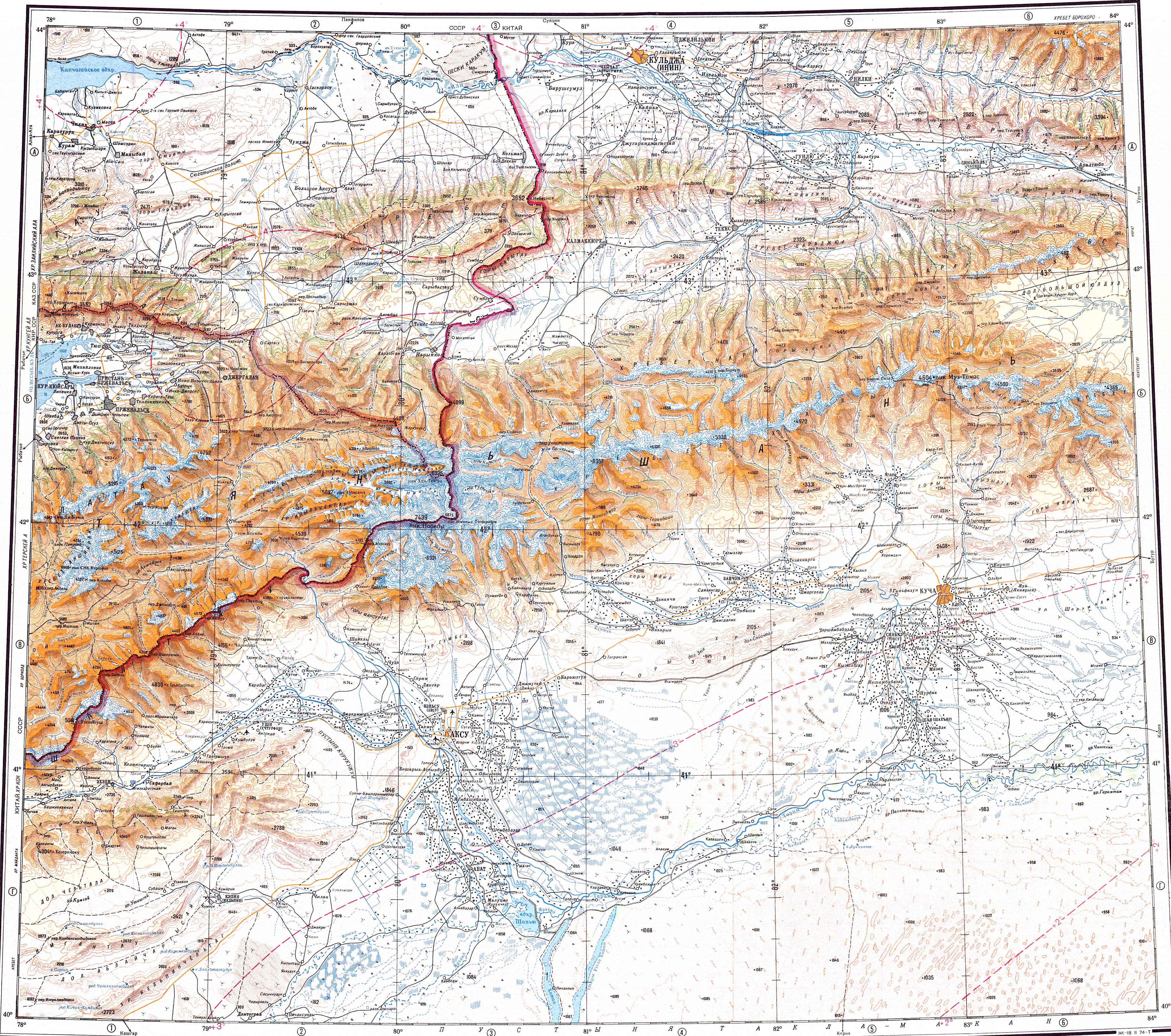
The lake lies 70 kilometers (43 mi) east of Kegen, near the road to Narynkol. The nearest village is Karasaz, 14 kilometers (8.7 mi) to the WNW. [2]
Geography
Tuzkol is a lake located at 1,959 meters (6,427 ft) in the upper course of the Charyn river in southeastern Kazakhstan. It lies in the intermontane basin of the Eltchin-Buyryuk and Karatau ranges, north of the Tien Shan. The lake is shallow and its water is bittern salty, with a concentration that can become very high in certain seasons owing to high evaporation. [3]
The lakeshore is flat and marshy and the bottom of the lake is muddy. The surrounding fields are a local livestock grazing area following the melting of the snows. [2] [4]
 |
Flora and fauna
In some stretches reeds grow along the lakeshore. Tuzkol is a 3,194 hectares (7,890 acres) Important Bird Area for the breeding, migrating and wintering of a number of water bird species, including the ruddy shelduck and the common crane. [5] [6]
See also
References
- ^ "K-44 Topographic Chart (in Russian)". Retrieved 8 January 2023.
- ^ a b Google Earth
- ^ Kazakhstan National encyclopedia, volume VIII / Chief editor A. Nysanbayev - Almaty "Kazakh encyclopedia" General editor, 1998 ISBN 5-89800-123-9
- ^ Тузколь горное озеро в Раймбекском районе, Алматинской области, Казахстан
- ^ Tuzkol Lake
- ^ Common Crane (Grus grus). Birds of Kyrgyzstan
External links
-
 Media related to
Tuzkol, Raiymbek District at Wikimedia Commons
Media related to
Tuzkol, Raiymbek District at Wikimedia Commons - Tuzkol – the Saltiest Mountain Lake in Kazakhstan
|
| This Kazakhstan location article is a stub. You can help Wikipedia by expanding it. |
| Tuzkol | |
|---|---|
| Тұзкөл | |
|
View of the lake | |
Tuzkol | |
| Location | Kegen Depression |
| Coordinates | 43°00′N 79°58′E / 43.000°N 79.967°E |
| Type | salt lake |
| Basin countries | Kazakhstan |
| Max. length | 5.7 kilometers (3.5 mi) |
| Max. width | 2.1 kilometers (1.3 mi) |
| Surface area | 6.6 square kilometers (2.5 sq mi) |
| Max. depth | 3 meters (9.8 ft) |
| Residence time | UTC+6 |
| Shore length1 | 16.6 kilometers (10.3 mi) |
| Surface elevation | 1,959 meters (6,427 ft) |
| Islands | 1 |
| 1 Shore length is not a well-defined measure. | |
Tuzkol ( Kazakh: Тұзкөл) is a high-altitude salt lake in Raiymbek District, Almaty Region, Kazakhstan. [1]
The lake lies 70 kilometers (43 mi) east of Kegen, near the road to Narynkol. The nearest village is Karasaz, 14 kilometers (8.7 mi) to the WNW. [2]
Geography
Tuzkol is a lake located at 1,959 meters (6,427 ft) in the upper course of the Charyn river in southeastern Kazakhstan. It lies in the intermontane basin of the Eltchin-Buyryuk and Karatau ranges, north of the Tien Shan. The lake is shallow and its water is bittern salty, with a concentration that can become very high in certain seasons owing to high evaporation. [3]
The lakeshore is flat and marshy and the bottom of the lake is muddy. The surrounding fields are a local livestock grazing area following the melting of the snows. [2] [4]
|
Flora and fauna
In some stretches reeds grow along the lakeshore. Tuzkol is a 3,194 hectares (7,890 acres) Important Bird Area for the breeding, migrating and wintering of a number of water bird species, including the ruddy shelduck and the common crane. [5] [6]
See also
References
- ^ "K-44 Topographic Chart (in Russian)". Retrieved 8 January 2023.
- ^ a b Google Earth
- ^ Kazakhstan National encyclopedia, volume VIII / Chief editor A. Nysanbayev - Almaty "Kazakh encyclopedia" General editor, 1998 ISBN 5-89800-123-9
- ^ Тузколь горное озеро в Раймбекском районе, Алматинской области, Казахстан
- ^ Tuzkol Lake
- ^ Common Crane (Grus grus). Birds of Kyrgyzstan
External links
-
Media related to
Tuzkol, Raiymbek District at Wikimedia Commons
- Tuzkol – the Saltiest Mountain Lake in Kazakhstan
|
| This Kazakhstan location article is a stub. You can help Wikipedia by expanding it. |